geo.wikisort.org - Mountains
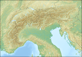
The Dolomites (Italian: Dolomiti [doloˈmiːti]; Ladin: Dolomites; German: Dolomiten [doloˈmiːtn̩] (![]() listen);[1] Venetian: Dołomiti [doɰoˈmiti]: Friulian: Dolomitis), also known as the Dolomite Mountains, Dolomite Alps or Dolomitic Alps, are a mountain range located in northeastern Italy. They form part of the Southern Limestone Alps and extend from the River Adige in the west to the Piave Valley (Pieve di Cadore) in the east. The northern and southern borders are defined by the Puster Valley and the Sugana Valley (Italian: Valsugana). The Dolomites are located in the regions of Veneto, Trentino-Alto Adige/Südtirol and Friuli Venezia Giulia,[2] covering an area shared between the provinces of Belluno, Vicenza, Verona, Trentino, South Tyrol, Udine and Pordenone.
listen);[1] Venetian: Dołomiti [doɰoˈmiti]: Friulian: Dolomitis), also known as the Dolomite Mountains, Dolomite Alps or Dolomitic Alps, are a mountain range located in northeastern Italy. They form part of the Southern Limestone Alps and extend from the River Adige in the west to the Piave Valley (Pieve di Cadore) in the east. The northern and southern borders are defined by the Puster Valley and the Sugana Valley (Italian: Valsugana). The Dolomites are located in the regions of Veneto, Trentino-Alto Adige/Südtirol and Friuli Venezia Giulia,[2] covering an area shared between the provinces of Belluno, Vicenza, Verona, Trentino, South Tyrol, Udine and Pordenone.
| Dolomites | |
|---|---|
| Italian: Dolomiti Ladin: Dolomites German: Dolomiten | |
 The Western Dolomites in Gherdëina | |
| Highest point | |
| Peak | Marmolada |
| Elevation | 3,343 m (10,968 ft) |
| Coordinates | 46°26′N 11°51′E |
| Dimensions | |
| Area | 15,942 km2 (6,155 sq mi) |
| Geography | |
 Dolomites Location of the Dolomites in the Alps | |
| Country | |
| Regions | Veneto, Trentino-Alto Adige/Südtirol and Friuli Venezia Giulia |
| Parent range | Alps |
| Geology | |
| Orogeny | Alpine orogeny |
| Age of rock | Mostly Triassic |
| Type of rock | Sedimentary rocks, dolomite and volcanic rocks |
| UNESCO World Heritage Site | |
|---|---|
 | |
| Criteria | Natural: vii, viii |
| Reference | 1237 |
| Inscription | 2002 (26th Session) |
| Area | 141,902.8 ha |
| Buffer zone | 89,266.7 ha |
Other mountain groups of similar geological structure are spread along the River Piave to the east – Dolomiti d'Oltrepiave; and far away over the Adige River to the west – Dolomiti di Brenta (Western Dolomites). A smaller group is called Piccole Dolomiti (Little Dolomites), located between the provinces of Trentino, Verona, and Vicenza.
The Dolomiti Bellunesi National Park and many other regional parks are located in the Dolomites. In August 2009, the Dolomites were declared a UNESCO World Heritage Site.
Etymology
The Dolomites, also known as the "Pale Mountains", take their name from the carbonate rock dolomite. This was named after the 18th-century French mineralogist Déodat Gratet de Dolomieu (1750–1801), who was the first to describe the mineral.[3]
History
For millennia, hunters and gatherers had advanced into the highest rocky regions and had probably also climbed some peaks. There is evidence that the Jesuit priest Franz von Wulfen from Klagenfurt climbed the Lungkofel and the Dürrenstein in the 1790s. In 1857 the Briton John Ball was the first to climb Monte Pelmo. Paul Grohmann later climbed numerous peaks such as the Antelao, Marmolata, Tofana, Monte Cristallo, and the Boè. Around 1860 the Agordin mountaineer Simone de Silvestro was the first person to consciously stand on the Civetta. Michael Innerkofler was one of the climbers of the Tre Cime di Lavaredo. Later very important local mountaineers, known for many first ascents, were Angelo Dibona and Giovanni Piaz.[4]
During the First World War, the front line between the Italian and Austro-Hungarian army ran through the Dolomites, where both sides used mines extensively. Open-air war museums are located at Cinque Torri (Five Towers), Monte Piana and Mount Lagazuoi. Many people visit the Dolomites to climb the vie ferrate, protected paths through the rock walls that were created during the war.
A number of long-distance footpaths traverse the Dolomites. They are called alte vie (German: Dolomiten Höhenwege – high paths), and are numbered 1 to 10. The trails take about a week to walk, and are served by numerous rifugi (huts). The first and the most renowned is the Alta Via 1. Radiocarbon dating has been used in the Alta Badia region to demonstrate a connection between landslide activity and climate change.[5]
Geography
The region is commonly divided into the Western and Eastern Dolomites, separated by a line following the Val Badia – Campolongo Pass – Cordevole Valley (Agordino) axis.
Current classification
The Dolomites may be divided into the following ranges:
- Sella
- Marmolada
- Tofane
- Langkofel Group
- Geisler Group
- Peitlerkofel Group
- Puez Group
- Fanes Group
- Schlern Group
- Rosengarten
- Latemar
- Pala
- Lüsen Mountains
- Civetta
- Pelmo
- Marmarole
- Cadini Group
- Cristallo Group
- Sorapiss
- Antelao
- Bosconero
- Vette Feltrine
- Schiara
- Prague Dolomites
- Sexten Dolomites
- Friulian Dolomites
Tourism and sports
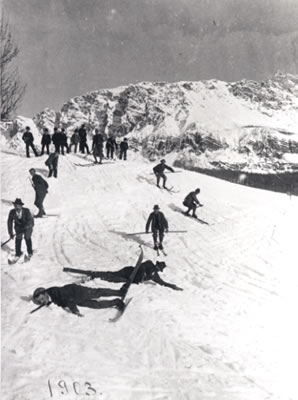
The Dolomites are renowned for skiing in the winter months and mountain climbing, hiking, cycling, and BASE jumping, as well as paragliding and hang gliding in summer and late spring/early autumn.[6][7] Free climbing has been a tradition in the Dolomites since 1887, when 17-year-old Georg Winkler soloed the first ascent of the pinnacle of the Vajolettürme.[8] The main centres include: Rocca Pietore alongside the Marmolada Glacier, which lies on the border of Trentino and Veneto, the small towns of Alleghe, Falcade, Auronzo, Cortina d'Ampezzo and the villages of Arabba, Urtijëi and San Martino di Castrozza, as well as the whole of the Fassa, Gardena and Badia valleys.[9]
The Maratona dles Dolomites, an annual single-day road bicycle race covering seven mountain passes of the Dolomites, occurs in the first week of July.
Other characteristic places are:
- Mount Pasubio and Strada delle 52 Gallerie (a military mule road built during World War I with 52 tunnels)
- Altopiano di Asiago and Calà del Sasso, with 4444 steps, the world's longest staircase open to the public.
Major peaks


| Name | metres | feet | Name | metres | feet |
|---|---|---|---|---|---|
| Marmolada | 3,343 | 10,968 | Pala di San Martino | 2,982 | 9,831 |
| Antelao | 3,264 | 10,706 | Rosengartenspitze / Catinaccio | 2,981 | 9,781 |
| Tofana di Mezzo | 3,241 | 10,633 | Cima di Fradusta | 2,941 | 9,715 |
| Sorapiss | 3,229 | 10,594 | Cimon del Froppa | 2,932 | 9,649 |
| Cristallo | 3,221 | 10,568 | Monte Agnèr | 2,872 | 9,416 |
| Monte Civetta | 3,220 | 10,564 | Fermedaturm | 2,867 | 9,407 |
| Cima di Vezzana | 3,192 | 10,470 | Cima d'Asta | 2,848 | 9,344 |
| Cimon della Pala | 3,184 | 10,453 | Cima di Canali | 2,846 | 9,338 |
| Langkofel / Sassolungo | 3,181 | 10,427 | Croda Grande | 2,839 | 9,315 |
| Monte Pelmo | 3,168 | 10,397 | Vajoletturm / Torri del Vajolet (highest) | 2,821 | 9,256 |
| Dreischusterspitze | 3,162 | 10,375 | Sass Maor | 2,816 | 9,239 |
| Boespitze / Piz Boè (Sella group) | 3,152 | 10,342 | Cima di Ball | 2,783 | 9,131 |
| Hohe Gaisl (Croda Rossa d'Ampezzo) | 3,148 | 10,329 | Cima della Madonna (Sass Maor) | 2,751 | 9,026 |
| Gran Vernel | 3,145 | 10,319 | Rosetta | 2,741 | 8,993 |
| Piz Popena | 3,143 | 10,312 | Croda da Lago | 2,716 | 8,911 |
| Grohmannspitze (Langkofel) | 3,126 | 10,256 | Central Grasleitenspitze | 2,705 | 8,875 |
| Zwölferkofel | 3,094 | 10,151 | Schlern | 2,562 | 8,406 |
| Elferkofel | 3,092 | 10,144 | Sasso di Mur | 2,554 | 8,380 |
| Piz dles Cunturines | 3,064 | 10,052 | Monte Siera[10] | 2,443 | 8,015 |
| Sass Rigais (Geislerspitzen) | 3,025 | 9,925 | Cima delle Dodici | 2,338 | 7,671 |
| Kesselkogel (Rosengarten) | 3,004 | 9,856 | Monte Pavione | 2,336 | 7,664 |
| Tre Cime di Lavaredo (Drei Zinnen) | 2,999 | 9,839 | Cima Palon | 2,239 | 7,346 |
| Fünffingerspitze | 2,997 | 9,833 | Cima di Posta | 2,235 | 7,333 |

Major passes


| Name | metres | feet |
|---|---|---|
| Ombretta Pass (Campitello to Caprile), footpath | 2,738 | 8,983 |
| Langkofeljoch (Gröden Valley to Campitello), footpath | 2,683 | 8,803 |
| Tschagerjoch (Karersee to the Vajolet Glen), footpath | 2,644 | 8,675 |
| Grasleiten Pass (Vajolet Glen to the Grasleiten Glen), footpath | 2,597 | 8,521 |
| Pravitale Pass (Rosetta Plateau to the Pravitale Glen), footpath | 2,580 | 8,465 |
| Comelle Pass (same to Cencenighe), footpath | 2,579 | 8,462 |
| Rosetta Pass (San Martino di Castrozza to the great limestone Rosetta plateau), footpath | 2,573 | 8,442 |
| Vajolet Pass (Tiers to the Vajolet Glen), footpath | 2,549 | 8,363 |
| Canali Pass (Primiero to Agordo), footpath | 2,497 | 8,193 |
| Tierseralpljoch (Campitello to Tiers), footpath | 2,455 | 8,055 |
| Ball Pass (San Martino di Castrozza to the Pravitale Glen), footpath | 2,450 | 8,038 |
| Forcella di Giralba (Sexten to Auronzo), footpath | 2,436 | 7,992 |
| Col dei Bos (Falzarego Glen to the Travernanzes Glen), footpath | 2,313 | 7,589 |
| Forcella Grande (San Vito to Auronzo), footpath | 2,262 | 7,422 |
| Pordoi Pass (Arabba to Val di Fassa), road | 2,250 | 7,382 |
| Sella Pass (Gröden Valley to Val di Fassa), road | 2,244 | 7,362 |
| Giau Pass (Cortina to Val Fiorentina), road | 2,236 | 7,336 |
| Tre Sassi Pass (Cortina to St Cassian), footpath | 2,199 | 7,215 |
| Valparola Pass (Cortina to St Cassian), road | 2,168 | 7,113 |
| Mahlknechtjoch (Upper Duron Glen to the Seiser Alp), footpath | 2,168 | 7,113 |
| Gardena Pass (Gröden Valley to Colfuschg), road | 2,121 | 6,959 |
| Falzarego Pass (Caprile to Cortina), road | 2,117 | 6,946 |
| Fedaja Pass (Val di Fassa to Caprile), bridle path | 2,046 | 6,713 |
| Valles Pass (Paneveggio to Falcade), road | 2,032 | 6,667 |
| Würzjoch (Eisacktal to Val Badia), road | 2,003 | 6,572 |
| Rolle Pass (Predazzo to San Martino di Castrozza and Primiero), road | 1,984 | 6,509 |
| Forcella Forada (Caprile to San Vito), bridle path | 1,975 | 6,480 |
| San Pellegrino Pass (Moena to Cencenighe), road | 1,910 | 6,267 |
| Campolongo Pass (Corvara to Arabba), road | 1,875 | 6,152 |
| Forcella d'Alleghe (Alleghe to the Zoldo Glen), footpath | 1,820 | 5,971 |
| Tre Croci Pass (Cortina to Auronzo), road | 1,808 | 5,932 |
| Furkel Pass (Mareo to Olang), road | 1,759 | 5,771 |
| Karerpass or Costalunga Pass (Welschnofen to Vigo di Fassa), road | 1,753 | 5,751 |
| Kreuzbergpass or Monte Croce Pass (Innichen and Sexten to the Piave Valley and Belluno), road | 1,638 | 5,374 |
| Ampezzo Pass (Toblach to Cortina and Belluno), path | 1,544 | 5,066 |
| Cereda Pass (Primiero to Agordo), road | 1,372 | 4,501 |
| Toblach Pass (Bruneck to Lienz), railway | 1,209 | 3,967 |
Major parks

|
|
|
See also
- Alta Via 1
- Belluno
- Brenta Group
- Dolomiti Bellunesi National Park
- Golden age of alpinism
- Italian front (World War I)
- Silver age of alpinism
- Strada delle 52 Gallerie
- Via Ferrata
- White Friday (1916)
- White War
References
- "Dolomiten" in Langenscheidt German-English Dictionary.
- "Dolomiti, le montagne rosa". italia.it (in Italian).
- Saussure le fils, M. de (1792): "Analyse de la dolomite". Journal de Physique, vol. 40, pp. 161–173.
- Die Besteigung der Berge - Die Dolomitgipfel werden erobert (German: The ascent of the mountains - the dolomite peaks are conquered)
- Borgatti, Lisa; Soldati, Mauro (2010-08-01). "Landslides as a geomorphological proxy for climate change: A record from the Dolomites (northern Italy)". Geomorphology. Landslide geomorphology in a changing environment. 120 (1–2): 56–64. Bibcode:2010Geomo.120...56B. doi:10.1016/j.geomorph.2009.09.015.
- Robert Draper (2015-08-16). "In Italy, Hiking and Haute Cuisine in the Dolomites - The New York Times". The New York Times. Retrieved 2020-04-18.
- Ingrid K. Williams (30 August 2018). "36 Hours in the Dolomites - The New York Times". The New York Times. Retrieved 2020-04-18.
- Huber, Alex. "The Perfect Perfume". Rock and Ice Magazine. Archived from the original on 2008-02-15.
- Amy Tara Koch (25 November 2019). "Hut Skiing in the Dolomites: Storybook Scenery and Grappa Included - The New York Times". The New York Times. Retrieved 2020-04-18.
- "Monte Siera".
Bibliography
- This article incorporates text from a publication now in the public domain: Coolidge, William Augustus Brevoort (1911). "Dolomites, The". In Chisholm, Hugh (ed.). Encyclopædia Britannica. Vol. 8 (11th ed.). Cambridge University Press. p. 394.
- Provincia di Belluno, Provincia Autonoma di Bolzano-Alto Adige Autonome Provinz Bozen-Südtirol, Provincia di Pordenone, Provincia Autonoma di Trento, Provincia di Udine, Regione Autonoma Friuli Venezia Giulia, 2008. Nomination of the Dolomites for inscription on the World Natural Heritage List UNESCO. Nomination Document. 363 pp. https://web.archive.org/web/20131225070444/http://fondazionedolomitiunesco.org/documentazione-2/01_DOLOMITES_nomination_document_jan2008_1236608233_1294933181.pdf
- "HD Pictures of the main areas of the Dolomites". Bruno Mandolesi.
- "360 degree panorama Dolomites". SiMedia Srl. Archived from the original on 26 January 2011. Retrieved 14 April 2010.
- Roger. "Walks and Via Ferrata in the Dolomites". CommunityWalk.com. Archived from the original on 8 January 2018. Retrieved 14 April 2010.
- "Strada delle 52 Gallerie". Eclectica.
- "Monte Piana in the Dolomites". Eclectica. August 21, 2006.
- "Via Ferrata Lagazuoi Tunnels". Eclectica. August 9, 2006.
- "Up to the Turquoise Lake". Eclectica. August 1, 2006.
External links
- Franco Grisa Timelapse
- North of Italy in 4K - Bashir Abu Shakra
- Dolomites on Hike.uno
- Italian official cartography (Istituto Geografico Militare - IGM); on-line version: www.pcn.minambiente.it
- Report on the via ferrata Bocchette di Brenta
National parks of Italy | ||
|---|---|---|
| National parks |
|  |
Mountain ranges of the Southern Limestone Alps according to the AVE | ||
|---|---|---|
Authority control | |
|---|---|
| General | |
| National libraries | |
| Other | |
На других языках
[de] Dolomiten
Die Dolomiten, italienisch Dolomiti, ladinisch Dolomites, sind eine Gebirgsgruppe der Südlichen Kalkalpen, werden aber auch den Südalpen zugerechnet. Sie verteilen sich auf die Regionen Venetien und Trentino-Südtirol in Italien bzw. – zu etwa gleichen Teilen – auf die Provinzen Belluno, Bozen – Südtirol und Trient. Seit 2009 gehören Teile der Dolomiten zum UNESCO-Weltnaturerbe Dolomiten. Sprachlich ist die Region durch deutsch- und italienischsprachige Gebiete charakterisiert, wozu noch eine kleinere Gruppe Ladiner kommt.- [en] Dolomites
[es] Dolomitas
Las/los Dolomitas[lower-alpha 1] (en italiano, Dolomiti; en alemán, Dolomiten; en ladino Dolomites; en friulano, Dolomitis), son un conjunto de macizos montañosos en los Alpes orientales italianos, al sur de la cadena principal alpina, casi en su totalidad incluidos en las regiones del Veneto, Trentino-Alto Adige y Friul-Venecia Julia (parte de las provincias de Belluno, Bolzano, Trento, Údine, Pordenone, Vicenza y Verona), con una pequeña parte también incluida en Austria (Dolomitas de Lienz). Es una de las zonas naturales y turísticas más reconocidas de los Alpes, que alberga un parque nacional y nueve parques naturales. Localidades como Cortina d'Ampezzo, Rocca Pietore, Ortisei, Arabba, Selva di Val Gardena y Corvara in Badia viven del turismo, sea naturalista o de deportes de invierno, —tiene una de los mayores zonas de esquí de Europa y la mayor italiana, Dolomiti Superski, con más de 1200 km de pistas—, o escalada.[fr] Dolomites
Les Dolomites (en italien : Dolomiti) constituent un massif montagneux des Préalpes orientales méridionales qui s'élève en Italie, à part environ égale entre le Trentin-Haut-Adige et la Vénétie. Il culmine à 3 343 mètres d'altitude à la Marmolada. Massif à géomorphologie bigarrée, il est caractérisé par une abondance de dolomie, roche sédimentaire carbonatée.[it] Dolomiti
Le Dolomiti (Dolomiten in tedesco, Dolomites in ladino, Dolomitis in friulano, Dołomiti in veneto), dette anche Monti pallidi, sono un insieme di gruppi montuosi delle Alpi Orientali italiane, a sud della catena principale alpina, quasi interamente comprese nelle regioni di Veneto, Trentino-Alto Adige e Friuli-Venezia Giulia (suddivise, in ordine di percentuale di distribuzione, tra le province di Belluno, Bolzano, Trento, Udine, Pordenone, e con una piccola parte compresa anche in Austria, le Dolomiti di Lienz).[ru] Доломитовые Альпы
Доломи́товые А́льпы (итал. Dolomiti, нем. Dolomiten) — горный массив в Восточных Альпах, входят в систему Южных Известняковых Альп. Массив располагается в северо-восточной части Италии на территории провинций Беллуно, Больцано, Порденоне, Тренто и Удине. Массив ограничен долинами рек: Изарко (северо-запад), Пустерия (север), Пьяве (восток и юго-восток), Брента (юго-запад) и Адидже (запад)[2]. Протяжённость системы составляет около 150 км, высшая точка — гора Мармолада (3342 м).Другой контент может иметь иную лицензию. Перед использованием материалов сайта WikiSort.org внимательно изучите правила лицензирования конкретных элементов наполнения сайта.
WikiSort.org - проект по пересортировке и дополнению контента Википедии