geo.wikisort.org - Mountains
The Langkofel Group (Ladin: Saslonch, Italian: Gruppo del Sassolungo) is a massif in the (western) Dolomites of the Italian Alps. It separates Gröden (to the north) and the Fassa valley (to the south), as well as the Sella massif (to the east) and the Rosengarten (to the west). Northwest of the Langkofel is the Seiser Alm. The highest point in the range is the eponymous Langkofel with a height of 3,181 metres. Taken together, the summits of the Langkofel form an arc which is only open towards the northwest. Within this arc there is only one small mountain, the Langkofelkarspitze, so that the group surrounds a kind of "inner courtyard".
| Langkofel Group | |
|---|---|
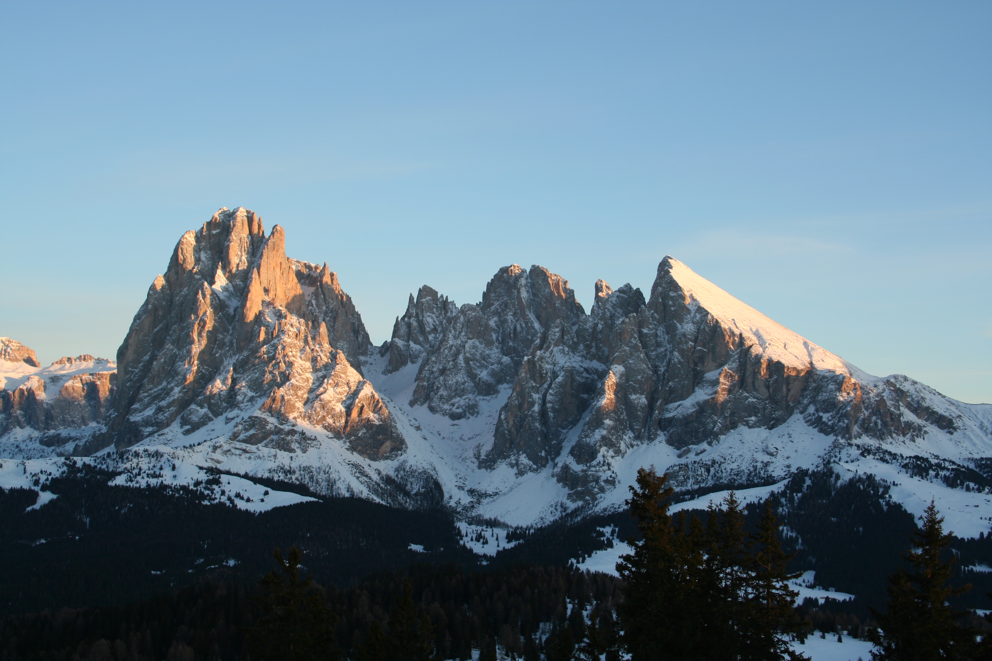 The Langkofel Group against the evening skies. | |
| Highest point | |
| Peak | Langkofel |
| Elevation | 3,181 m s.l.m. |
| Geography | |
 | |
| State | Trentino-Südtirol, Italy |
| Range coordinates | 46°31′29″N 11°44′07″E |
| Parent range | Dolomites |
Geology
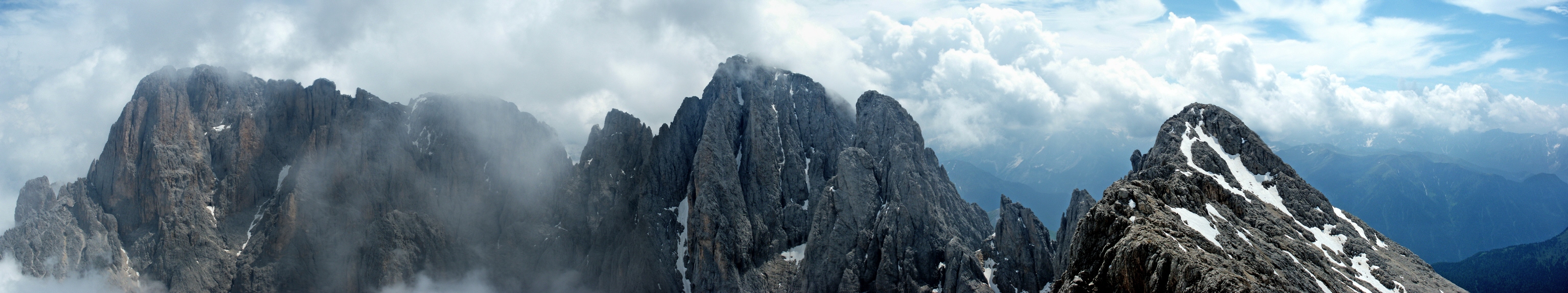
The region was formed in the early Triassic period (about 230 million years ago) as a coral reef in a shallow tropical sea. Hard limestone was able to form on the outside of the reef, whilst the rock in the interior remained brittle and was quickly eroded away following the uplifting of the range. This left a garland of mountains which, in a clockwise direction, are the Langkofel, Langkofeleck, Fünffingerspitze, Grohmannspitze, Innerkoflerturm, Zahnkofel and Plattkofel.
Summits
- Grohmannspitze (Italian: Punta Grohmann, Sasso Levante, Ladin: Sas da duman)
- Innerkoflerturm
- Zahnkofel (Il Dente/l Dënt)
- Langkofelkarspitze
- Plattkofel (Sasso Piatto/Sasplat)
- Fünffingerspitze (Punta Cinquedita)
- Langkofel (Sasso Lungo/Saslonch)
 Langkofel Group, labelled
 Aerial photograph of the Langkofel Group
 The group seen from the Plans de Cunfin
 The Langkofel Group from the Sella pass
 Gondola of the Telecabin Forcella del Sassolungo


Alpine huts
- Langkofel Hut (2256 m, also Rifugio Vicenza, in the Langkofel Cirque (Langkofelkar))
- Emilio Comici Hut (2153 m, private, at the foot of the Langkofel)
- Toni Demetz Hut (2685 m, private, in the Langkofel Col (Langkofelscharte))
- Friedrich August Hut (2298 m, private, on the Friedrich August Way from Sellajoch to the Plattkofel Hut)
- Des Alpes Hut (2395 m, private, on the Rodella Col, cable car from Campitello di Fassa)
- Sandro Pertini Hut (2300 m, private, on the Frederick Augustus Way (Friedrich-August-Weg))
- Plattkofel Hut (2300 m, private, west of the Plattkofel)
- Schutzhaus Sellajoch (2180 m, private, on the road to the Sellajoch below the top of the pass)
- Williams Hut (2100 m, private, at the foot of the Plattkofel)
Tourism
In Summer a gondola lift runs from Sellajoch up to the col of Langkofelscharte and the Toni Demetz refuge hut. From there both the Langkofel (via the Langkofel Hut, Confinböden and the Emilio Comici Hut), as well as the Plattkofel (via the Langkofel Hut, Plattkofel Hut and Frederick Augustus Way) may be circled on hiking trails. The Plattkofel may be reached from the Langkofelkar on the klettersteig route known as the Oskar Schuster Steig and from the Plattkofel Hut over the steep western flank (here without climbing). Between the Langkofel and the Sellajoch is the area of rockslides known as the "Rocky Town" (Steinernen Stadt), notable especially for its rich flora.
In winter there are ski areas at the foot of the Langkofel Group: the Col Rodella (on the Sellajoch), Plan de Gralba, Ciampinoi (with its well-known Saslong world cup run) and Monte Pana/Mont de Sëura. The famous Sella Ronda, a circuit of the Sella Group on ski pistes both clockwise and anticlockwise, also runs over these pistes.
External links
Authority control | |
|---|---|
| General |
|
| National libraries | |
На других языках
[de] Langkofelgruppe
Die Langkofelgruppe (italienisch gruppo del Sassolungo) ist ein Bergmassiv der westlichen Dolomiten. Sie befindet sich zwischen Gröden (im Norden) und dem Fassatal (im Süden), sowie dem Sellamassiv (im Osten), dem Rosengarten (im Südwesten) und der Schlerngruppe (im Westen). Nordwestlich der Langkofelgruppe liegt die Seiser Alm. Die höchste Erhebung ist der namensgebende Langkofel mit einer Höhe von 3181 m s.l.m.. Die Gruppengipfel bilden in ihrer Gesamtheit einen Kreisbogen, der sich nur nach Nordwesten öffnet und somit eine Art Innenhof aufweist.- [en] Langkofel Group
[it] Gruppo del Sassolungo
Il gruppo del Sassolungo (Langkofelgruppe in tedesco) è un gruppo montuoso delle Dolomiti, in Trentino-Alto Adige, collocato tra le provincie di Trento e Bolzano, tra la val Gardena e la val di Fassa.Другой контент может иметь иную лицензию. Перед использованием материалов сайта WikiSort.org внимательно изучите правила лицензирования конкретных элементов наполнения сайта.
WikiSort.org - проект по пересортировке и дополнению контента Википедии