geo.wikisort.org - Mountains
Sorapiss, also referred to as Sorapis or Punta Sorapiss, is a mountain in the Dolomites within the Veneto region of northern Italy. Situated in the comune of Cortina d'Ampezzo, it has an elevation of 3,205 metres (10,515 ft). In its vicinity is a mountain pass of the same name, as well as Sorapiss Lake (Lago di Sorapiss), at the foot of the mountain. The mountain range is part of the "Natural Park of the Ampezzo Dolomites".[2]
| Sorapiss | |
|---|---|
 Sorapiss | |
| Highest point | |
| Elevation | 3,205 m (10,515 ft) |
| Prominence | 1,085 m (3,560 ft)[1] |
| Listing | Alpine mountains above 3000 m |
| Coordinates | 46°30′N 12°13′E[1] |
| Geography | |
 Sorapiss Location in the Alps | |
| Location | Veneto, Italy |
| Parent range | Dolomites |
Description

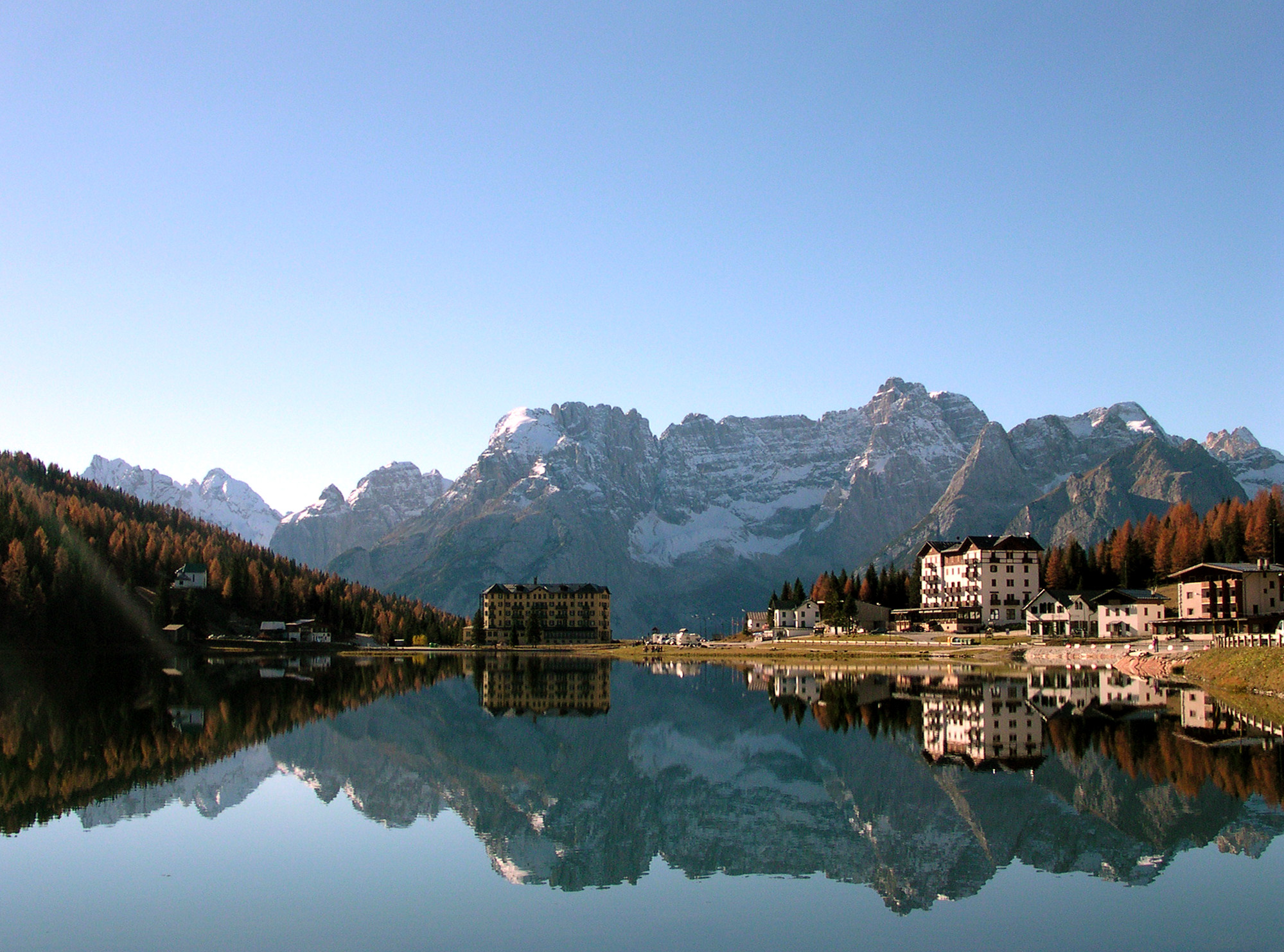
Sorapiss, with its huge perpendicular faces,[3] forms part of the mountainous backdrop to the resort town of Cortina, situated roughly 9 kilometres (5.6 mi) to the southeast of the town. The limestone dolomite formations, which are irregular, rugged and sharp-edged peaks, are part of the Eastern Alps.[4] The Cristallo group lies to the north past the Passo Tre Croci, and its southern neighbour is the Antelao. A path to Sorapiss starts at Passo Tre Croci and continues along an easy slope, reaching the refuge at the base of the Sorapiss range, close to Lago di Sorapiss, which is at an elevation of 1,923 metres (6,309 ft).[5]
The elevation of Sorapiss is 3,205 metres (10,515 ft).[6] The mountain has three ridges: a central ridge, a southern ridge, which is the part of the mountain that can be seen from Cortina, and, beyond a high pass and little to the west, a northern ridge that culminates in the skiing area of Mount Faloria. There are three glaciers on the mountain's slopes, although these have been melting considerably in recent years.[7] Lago Sorapiss, at the foot of the mountain,[8] is a glacial lake at an elevation 1,925 metres (6,316 ft).
History

There are three refuges in the vicinity: Rifugio Tondi di Faloria at 2,327 metres (7,635 ft),[9] Rifugio Alfonso Vandelli at 1,926 metres (6,319 ft) and Rifugio San Marco. Rifugio Alfonso Vandelli was built by Austrians in 1891 on the banks of Lago di Sorapiss. In 1895 it was destroyed by an avalanche, but was rebuilt the following year in a more sheltered spot.[10] At the end of World War I in 1918, Cortina d'Ampezzo became part of the Kingdom of Italy (1918) and the refuge became the property of the CAI (Club Alpino Italiano) of Venice. In 1924, thanks to a donation by Cesare Luigi Luzzati, a new refuge was built.[10] A fire destroyed it completely in 1959, and it was again reconstructed; the current shelter was opened on 18 September 1966 and was named after the president of the CAI of Venice, Alfonso Vandelli.[10]
Paul Grohmann made the first ascent of the mountain in September 1864, taking 8 hours and 30 minutes.[11] There are at least two routes to the summit: the Grohmann-Weg, which crosses the mountain's west flank, joining the S. Vito route near the summit, and the Muller-Weg, which traverses the east glacier and ascends direct over the precipices on the northeast side.[12]
Flora
The flora on Sorapiss includes Festucetum pulchellae (slopes),[13] Euphrasio-Globularietum (base),[14] and Drabetum hoppeanae (on the range).[15]
Legend


There is a legend associated with the name of Sorapiss, which in local dialect means "above the waterfall". A "peace-loving" king named Sorapiss turned himself into a rocky mountain during a course of unexpected events.[16] A witch had bewitched the king's impulsive daughter Misurina by promising her a magical mirror as a reward for providing shade to her house. This was honoured by her doting father, who turned himself into a mountain. At a later date, Misurina, demonstrating a sense of gratitude towards her father, cried and shed tears which formed the Lago di Sorapiss at the foot of the large cliff of Sorapiss, the immobilized form of her father.[16]
References
- "Punta Sorapiss, Italy". Peakbagger.com. Retrieved 16 January 2015.
- Natural Park of the Ampezzo Dolomites
- Baedeker 1883, p. 282.
- Raza 1990, p. 538.
- Fabris 2005, p. 62.
- Reynolds 2011, p. 451.
- "Sorapiss - summitpost.org". summitpost.org. Retrieved 16 January 2015.
- Reynolds 2011, p. 452.
- Carnovalini & Carnovalini 1987, p. 160.
- "Alfonso Vandelli" (PDF) (in Italian). Caiveneto.it. Retrieved 20 April 2015.
- Robertson 1903, p. 205.
- Baedeker 1899, p. 418.
- Pignatti, Pignatti & Isenberg 2013, p. 361.
- Pignatti, Pignatti & Isenberg 2013, p. 137.
- Pignatti, Pignatti & Isenberg 2013, p. 342.
- Price 2015, p. 110.
Sources
- Baedeker, Karl (1899). Eastern Alps (Public domain ed.). Dulau and Company.
- Baedeker, Karl (1883). The Eastern Alps, Including the Bavarian Highlands, the Tyrol, Salzkammergut, Styria, Carinthia, Carniola, and Istria: Handbook for Travellers (Public domain ed.). K. Baedeker. p. 282.
- Carnovalini, Riccardo; Carnovalini, Cristina (1987). Grandi trekking italiani: 200 giorni di cammino su Alpi e Appennini (in Italian). Edizioni Mediterranee.
- Fabris, Marissa (1 January 2005). Venice and the Veneto. Hunter Publishing, Inc. p. 62. ISBN 978-1-58843-519-4.
- Pignatti, Erika; Pignatti, Sandro; Isenberg, Philip (5 December 2013). Plant Life of the Dolomites: Vegetation Structure and Ecology. Springer Science & Business Media. ISBN 978-3-642-31043-0.
- Price, Gillian (20 March 2015). Shorter Walks in the Dolomites. Cicerone Press. ISBN 978-1-78362-179-8.
- Raza, Moonis (1 January 1990). Geographical Dictionary Of The World In The Early 20th Century With Pronouncing Gazetteer (in 2 Vos.). Concept Publishing Company. ISBN 978-81-7268-011-4.
- Reynolds, Kev (21 July 2011). Walking in the Alps: A comprehensive guide to walking and trekking throughout the Alps. Cicerone Press Limited. ISBN 978-1-84965-438-8.
- Robertson, Alexander (1903). Through the Dolomities. George Allen.
Further reading
- Italiano, Touring club (January 1999). Italy: A Complete Guide to 1,000 Towns and Cities and Their Landmarks, with 80 Regional Tours. Touring Editore. ISBN 978-88-365-1522-6.
- Lifestyle, Michelin Travel & (1 March 2012). Michelin Green Guide Italy. Michelin Travel & Lifestyle. ISBN 978-2-06-718235-6.
- Marcuzzi, Giorgio (1 January 1979). European Ecosystems. Springer Verlag Gmbh. ISBN 978-90-6193-216-1.
External links
 Media related to Sorapiss at Wikimedia Commons
Comune of Cortina d'Ampezzo | ||
|---|---|---|
| Geography |
|  |
| Architecture |
| |
| Sport |
| |
| People |
| |
На других языках
[de] Sorapiss
Sorapiss (ladinisch Sorapísc) ist eine Berggruppe in den italienischen Dolomiten südöstlich von Cortina d’Ampezzo. Die Gruppe überragt das Valle del Boite (Boitetal). Höchster Gipfel ist die Punta Sorapiss mit 3205 m s.l.m. Als Teil der von der UNESCO unter „Nördliche Dolomiten“ zusammengefassten Dolomitengruppen, gehört die Sorapiss-Gruppe mit allen Untergruppen seit dem 26. Juni 2009 zum UNESCO Welterbe Dolomiten.[1]- [en] Sorapiss
[fr] Sorapiss
Le Sorapiss (ou Sorapis, Punta Sorapiss) est un sommet et un chaînon montagneux culminant à 3 205 m d'altitude dans le groupe des Dolomites d'Ampezzo, dans le massif des Dolomites, dans les Alpes italiennes. Le chaînon s'élève dans la province de Belluno sur les municipalités de Cortina d'Ampezzo et de San Vito di Cadore.[it] Gruppo del Sorapiss
Il Gruppo del Sorapiss[1] (o, più semplicemente, Sorapíss o Sorapís, originariamente Sorapisc in ladino[2]) è uno dei principali gruppi delle Dolomiti Ampezzane in provincia di Belluno. Il massiccio del Sorapiss è compreso nei territori di Cortina d'Ampezzo, San Vito di Cadore e Auronzo di Cadore. Ha la forma di una U, aperta verso la valle dell'Ansiei (nordest).Другой контент может иметь иную лицензию. Перед использованием материалов сайта WikiSort.org внимательно изучите правила лицензирования конкретных элементов наполнения сайта.
WikiSort.org - проект по пересортировке и дополнению контента Википедии