geo.wikisort.org - Mountains
The Barre des Écrins (French pronunciation: [baʁ dez‿ekʁɛ̃]) is a mountain in the French Alps with a peak elevation of 4,102 metres (13,458 ft). It is the highest peak of the Massif des Écrins and the Dauphiné Alps and the most southerly alpine peak in Europe that is higher than 4,000 metres. It is the only 4,000-metre mountain in France that lies outside the Mont Blanc Massif. Before the annexation of Savoy in 1860 it was the highest mountain in France.
| Barre des Écrins | |
|---|---|
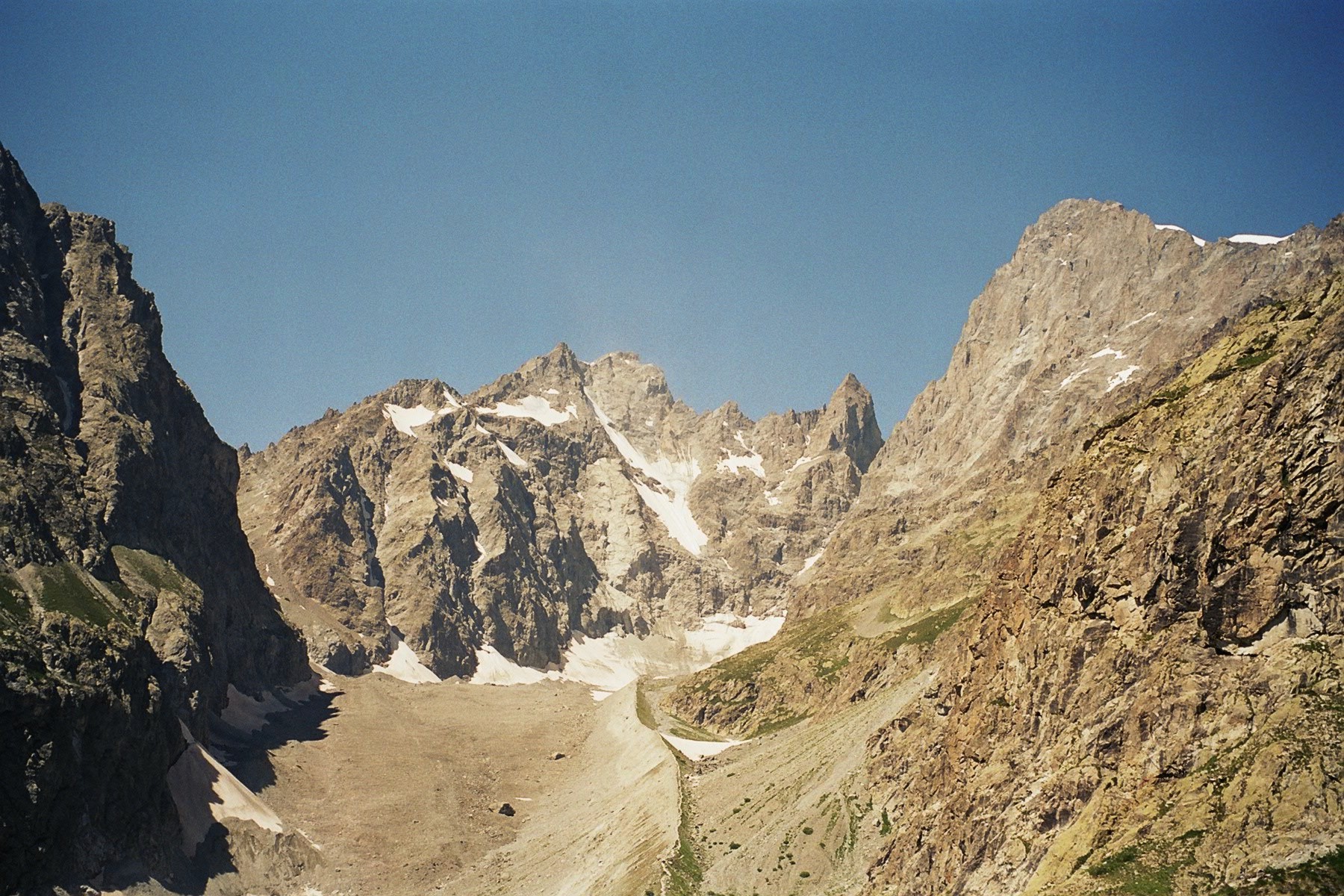
 The Barre des Écrins (4,102 m) in Hautes Alpes, France and the Glacier Blanc | |
| Highest point | |
| Elevation | 4,102 m (13,458 ft)[1] |
| Prominence | 2,045 m (6,709 ft)[1] |
| Isolation | 107.3 km (66.7 mi) |
| Listing | Ultra |
| Coordinates | 44°55′21″N 06°21′36″E[1] |
| Geography | |
 Barre des Écrins France | |
| Location | Hautes-Alpes, France |
| Parent range | Dauphiné Alps |
| Climbing | |
| First ascent | 25 June 1864 by A. W. Moore, Horace Walker and Edward Whymper with guides Michel Croz, Christian Almer Senior and Christian Almer Junior |
| Easiest route | snow/rock climb |
Geography

Location
The Barre des Écrins is the highest peak in the Provence-Alpes-Côte d'Azur region including all of Occitania and the Southern Alps. It is located in the commune of Pelvoux and is situated near the Drainage divide between the Durance and the Vénéon. This divide passes 250 metres west of the summit, along the ridge that leads to the summit of the sub-peak Dôme des Écrins (4088 metres). The south face of the mountain is rocky while the north face is ice as it is the starting point of the Glacier Blanc.
The mountain is surrounded by four glaciers: to the north-west is the Bonne Pierre glacier, to the north-east the Glacier Blanc, to the south-west the Glacier du Vallon de la Pilatte, and finally in the south-east the Glacier Noir. It is separated from the Snow Dome of Écrins (4015 m) by the Lory Gap (3974 m) to the west, the Barre Noir (3751 m) by the Écrins Gap (3661 m) to the north-east and by Fifre (3699 m) via the Col des Avalanches (3499 m) to the south.
Geology
The mountain consists of migmatized gneiss, an acidic rock composed of quartz-feldspar. On the upper slopes there is an amphibolic face over the top of the migmatized gneiss forming the top. These formations overlap a large granite Pluton that forms the summit of Pelvoux.[2][3][4]
History
The Écrins were discovered by geographers belatedly in the 19th century when they were the highest point in France (Savoy being part of the Kingdom of Sardinia at that time). The mountains are actually located on the borders of the Oisans and Briançonnais with the highest point completely in Briançonnais. They were sometimes called "point of Arsines" by locals.
The Englishmen A. W Moore, Horace Walker, and Edward Whymper, guided by Michel Croz from Chamonix and Christian Almer from Switzerland, made the first ascent of the Barre des Écrins on 25 June 1864. They cut steps on the north face of the Barre until they reached the top of the eastern edge via the Whymper corridor. They then reached the top of this high ridge which was composed of very unstable rocks. Edward Whymper described the ascension in his book Scrambles Amongst the Alps in the Years 1860-69.[5][6]
William Auguste Coolidge made the first direct climb up the north face of the Barre des Ecrins in July 1870 by cutting 500 steps.[7]
The first ascent without a guide is credited to Frederick Gardiner in 1878 accompanied by Charles and Lawrence Pilkington.
The southern face was climbed for the first time in 1880 by Pierre Gaspard together with Henri Duhamel. The south pillar, a part of the Black glacier ending at the top, was climbed for the first time in 1944 by the famous couple of climbers Jeanne and Jean Franco.[5]
Ascent
The Barre des Écrins attracts many climbers and has many routes to the top.[8]
The mountain is traditionally scaled from the Pré de Madame Carle in the valley of Ailefroide. The normal route climbs the entire length of the Glacier Blanc. This is a much-used route, because it is the usual way to the Dôme des Écrins, one of the most easily climbed 4,000 m alpine peaks. It starts from the Refuge des Écrins and climbs the north face almost up to the Lory saddle (3,974 m), where the routes to the Dôme and the Barre divide. The ascent of the Barre continues by a rocky arête all the way to the summit. The guides from La Bérarde have equipped the Col des Écrins with cables allowing them to bring their clients to the summit.
Other more challenging routes to the summit exist, such as the South Face rated AD (Fairly Difficult). The quality of the rock on the mountain ranges from poor to average and especially on the South Face of the mountain the risk of rockfall is significant.
It is possible to climb the Direct Coolidge in late spring directly to the summit with crampons and an ice axe. Depending on snow conditions, this route can also be done on skis.
The south-north traverse of the Barre des Écrins bar is also one of the classic routes of the massif.
In summer it is possible to climb a steep path on the south face with the Pilier Sud being the most traveled route.
The record for an ascent on foot is 1 hour 55 minutes by Mathéo Jacquemoud in June 2012, starting from Pré de Madame Carle (1874 m) by the normal route of the Dôme and the Whymper corridor. He beat the old record by Hubert Fievet (2 hours 3 minutes in 1998).[9]
The record for round-trip ski mountaineering is 2 hours 51 minutes by Nicolas Bonnet in 2009 from the Pré de Madame Carle.[10]

Longest line of sight
The Barre des Écrins is the subject of the longest photographed and recognised line of sight on Earth. In July 2016, Marc Bret took a photograph of the mountain from the Pic de Finestrelles in the Pyrenees, some 443 km distant.
See also
- List of 4000 metre peaks of the Alps
References
- "Europe Ultra-Prominences". Peaklist.org. Retrieved 2014-05-24.
- Geological Map of France at 1:50000 consulted on InfoTerre (Saint-Christophe-en-Oisans page). (in French)
- J.-C. Barfêtry and A. Pécher, Notice on the Saint-Christophe-en-Oisans page, 1984, BRGM, p. 21–23, online 10 December 2006, consulted on 6 February 2013 (in French)
- Maurice Gidon, The Barre des Écrins and the right flank of the high Vénéon, 1 June 2010, online 10 July 2011, consulted on 6 February 2013 (in French)
- Richard Goedeke, 4000 des Alpes, Libris, coll. Les Guides Libris, June 2007, 22 pages.
- Scrambles Amongst the Alps in the Years 1860-69, Edward Whymper, Chapter IX p. 201-221
- Barre des Écrins, summitpost.org.
- Topo Mountaineering, The Ways to the top. (in French)
- A record on the barre des Écrins. (in French)
- Record of Écrins alpine skiing 2009. (in French)
External links
- The Barre des Écrins on SummitPost
- Climbing the Barre des Écrins in pictures (in French)
- Barre des Écrins at 4000er.de (in German)
Authority control | |
|---|---|
| General |
|
| National libraries | |
На других языках
[de] Barre des Écrins
Die Barre des Écrins ist der höchste Gipfel der als Écrins-Massiv, Les Écrins oder Pelvoux-Massiv bezeichneten Gebirgsgruppe in den französischen Dauphiné-Alpen. Mit einer Höhe von 4102 m ist sie nicht nur der südlichste und westlichste Viertausender der Alpen, sondern einer der prominentesten und dominantesten Gipfel im gesamten Alpenraum.- [en] Barre des Écrins
[fr] Barre des Écrins
La barre des Écrins est un sommet des Alpes françaises culminant à 4 101 mètres d'altitude. Point culminant du massif des Écrins, du département des Hautes-Alpes et plus généralement du Dauphiné, il est le plus méridional des « 4 000 alpins ». Avant l'annexion de la Savoie en 1860, il était le point culminant de la France.[it] Barre des Écrins
La Barre des Écrins (4.102 metri) è la montagna più alta del Massiccio des Écrins e il quattromila alpino più occidentale e meridionale, posto all'interno delle Alpi del Delfinato, l'unico interamente in territorio francese, tra i dipartimenti dell'Isère e delle Alte Alpi, in località Pelvoux.[ru] Барр-дез-Экрен
Барр-дез-Экре́н (фр. Barre des Écrins) — вершина высотой 4102 метра над уровнем моря, расположенная на территории Франции в Альпах Дофине. Была высшей точкой Франции вплоть до присоединения Савойи с вершиной Монблан (4810 метров) в 1860 году. Барр-дез-Экрен является высшей точкой массива Дез-Экрен[en] в национальном парке Экрен и самой южной вершиной-четырёхтысячником Альп.Другой контент может иметь иную лицензию. Перед использованием материалов сайта WikiSort.org внимательно изучите правила лицензирования конкретных элементов наполнения сайта.
WikiSort.org - проект по пересортировке и дополнению контента Википедии