geo.wikisort.org - Mountains
The Taygetus, Taugetus, Taygetos or Taÿgetus (Greek: Ταΰγετος, romanized: Taygetos) is a mountain range on the Peloponnese peninsula in Southern Greece. The highest mountain of the range is Mount Taygetus, also known as "Profitis Ilias", or "Prophet Elias" (Elijah).
| Mount Taygetus | |
|---|---|
| Ταΰγετος Profitis Ilias (HP) | |
 | |
| Highest point | |
| Elevation | 2,405 m (7,890 ft)[1] |
| Prominence | 2,344 m (7,690 ft)[1] |
| Listing | Ultra |
| Coordinates | 36°57′14″N 22°21′08″E[1] |
| Geography | |
 Mount Taygetus Greece | |
| Location | Peloponnese, Greece |
| Climbing | |
| Easiest route | Hike, some rock scrambling |

The name is one of the oldest recorded in Europe, appearing in the Odyssey.[2] In classical mythology, it was associated to the nymph Taygete and it was named after her.[3] During Byzantine times and up until the 19th century, the mountain was also known as Pentadaktylos (Πενταδάκτυλος; Greek for five-fingered, a common name during that period).
Geography
Physical
The Taygetus Massif is about 100 km (62 mi) long, extending from the center of the Peloponnese to Cape Matapan, its southernmost extremity. It contains the tallest mountain in the Peloponnese, the Profitis Ilias summit, reaching 2,405 m (7,890 ft);[4] this is probably the classical Mount Taléton mentioned by Pausanias.[5] The summit is an ultra-prominent peak. It is prominent above the Isthmus of Corinth, which separating the Peloponnese from mainland Greece, rises only to approximately 60 m (200 ft). Numerous creeks wash down from the mountains and the Eurotas has some of its headwaters in the northern part of the range. The western side of the massif houses the headwaters of the Vyros Gorge, which carries winter snowmelt down the mountain, emptying into the Messenian Gulf in the town of Kardamyli.
Political

Taygetus overlooks the cities of Sparti and Kalamata, whose skyline it dominates. The mountain range lies within the prefectures of Arcadia, Laconia and Messenia. Taygetus is crossed by Greek National Road 82, which links Kalamata to Sparti and separates Northern Taygetus from the Central Range. The Rindomo Gorge separates the Central Range from Southern Taygetos. The section of Taygetus that forms the backbone of the Mani Peninsula is also known as Saggias, and is often not considered part of Taygetus. The central part of the mountain range is commonly called "Skoteini Plevra", which means "the dark side" because the villages located there do not receive as much sunshine in the early morning and the late afternoon hours.
Geology

The mountains of southern Europe that fringe the Mediterranean Sea and run generally in an east-west direction are of the folded type generated by collision of the northward-moving African Plate with the Eurasian Plate. Where the northern edge of the African Plate is being subducted in an irregular line a second orogeny occurs that is not entirely understood. The mountains of Italy and Greece are a combination of folded mountains and fault-block mountains running in a northwest–southeast direction.
The Hellenic Subduction carries the leading edge of the African Plate under the Aegean Sea Plate at the Hellenic Trench. It follows an arc around the outer edge of the Peloponnese and Crete. The subduction on the west is to the northeast, on the east to the northwest, and north in the center. The average direction is N 21° E. In the islands and southern Greece a fault-block mountain orogeny prevails due to a double set of crustal movements. On the one hand the Aegean Sea Plate is being raised by the subduction. On the other hand, north–south extensional movements, yet unexplained, are pulling the plate apart, creating normal extensional faults and generating a parallel sequence of horsts and grabens, or rift valleys, running in a north–south direction.[6]
Mount Taygetus is a limestone horst bordering the Eurotas Rift Valley. Below its eastern face is the Sparta fault, a normal fault striking perpendicular to the direction of extension. Footwall scarps are visible on the eastern side of Taygetus at the base of its spurs. They result from sudden slippages of the hanging wall in the direction of the dip, causing earthquakes. Single earthquakes result in 1–12 m of scarp. The Sparta fault is zig-zag in strike, varying between N 170° E and N 140° E. The maximum slippage has been 10–12 m in three increments. The earthquake of 464 BC, which levelled Sparta, resulted from a slippage of 3–4 m over a length of 20 km of the fault. The slip rate has been about 1 mm per year suggesting an average interval between earthquakes of 3000 years.[7]
Ecology
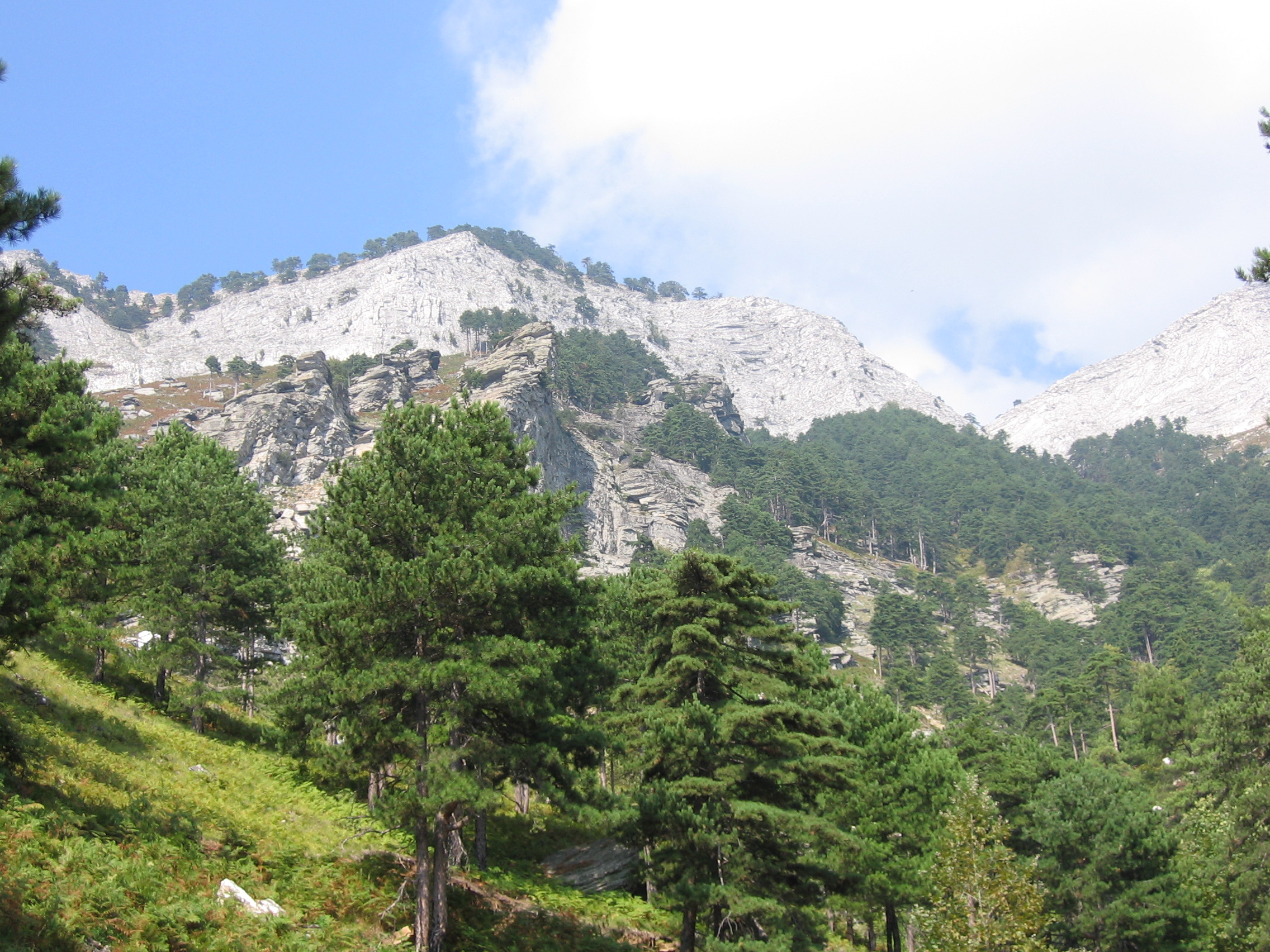

The slopes of Taygetus are heavily forested, primarily with Greek fir (Abies cephalonica) and black pine (Pinus nigra). Devastating fires in 2005 and 2007 consumed much of the forests on the central west slopes, and only about half remain.
History
The slopes of Taygetus have been inhabited since at least Mycenean times. The site of Arkina, near the village of Arna, contains three beehive tombs and is still unexplored. Taygetus was important as one of Sparta's natural defenses. The Spartans threw criminals into a chasm of Taygetus known as Ceadas or Caeadas (Greek: Καιάδας).[8] Recent evidence, found by the University of Athens, discovered remains of adult individuals which appeared to confirm that Ceadas was mainly a place of punishment for criminals, traitors and captives.[9]
It was a long-standing myth, started by Plutarch, that unwanted Spartan newborns were abandoned there in a practice called infant exposure. According to an Open University online course, "The first century CE writer Plutarch explains that Sparta had a ritual by which newborn babies were judged by the elders and those thought unfit to be allowed to live were left at the foot of Mount Taygetos. However, no other source tells us this about Spartan practices, and no infant remains have been found at this site."[10] While bones have been found at the site, a study determined they all belonged to adolescents and adults.[11]
At the ancient period, on spring women tied around their necks a plant which was growing on the mountain and was called Charisia. This way they wanted to make themselves more passionately beloved by men.[12]
During the era of barbarian invasions, Taygetus served as a shelter for the native population. Many of the villages in its slopes date from this period. In Medieval times, the citadel and monastery of Mystras was built on the steep slopes, and became a center of Byzantine civilization and served as the capital of the Despotate of the Morea. Mystras remains occupied by a tiny religious community. The buildings are remarkably well-preserved and a major tourist attraction in the region. It is a UNESCO World Heritage Site.
Religion
The peak known as Taleton, above Bryseae, was 'dedicated' to Helios, the Sun, to whom horses were sacrificed.[13] Taleton was also 'dedicated' to Zeus.[14] Today, the mountain is closely associated with the holy Prophet Elias, and every year on the 20th of July (the Greek Orthodox name day for the Prophet Elias), the small chapel at the peak holds a large festival, including a massive bonfire in commemoration of the Prophet Elias (a Greek-style transliteration of 'Eliyah' (אליה), the prophet Elijah), as he is believed to have ascended up into heaven in a chariot of fire. The bonfire can be seen from anywhere with clear view of the summit, and it is for this reason that the town of Kardamyli is a local gathering point for those who wish to view the fire without having to climb the mountain.
Recreation
The highest point, Profitis Ilias, is a popular hiking destination and European walking route E4 runs along the lower slopes of the range. The view from the Profitis Ilias includes most of the Evrotas valley and the Parnon range to the east, while the view towards the west includes Kalamata and the eastern half of Messenia. Most of the southwestern part of Arcadia can also be seen.
See also
References
- "Europe Ultra-Prominences". Peaklist.org. Retrieved 2014-05-25.
- Liddell, Henry George; Scott, Robert (1940). "Ταΰγετον". In Jones, Henry Stuart (ed.). A Greek-English Lexicon. Oxford: Clarendon Press.
- Pseudo-Plutarch, De fluviis, 17
- "Other map sources give the elevation as 2407m, but GPS readings seem to confirm the 2404m value on the Greek topographic maps." "Europe Ultra-Prominences" - Footnote#13. Peaklist.org. Retrieved 2014-05-25.
- Waterhouse, Helen; Simpson, R. Hope (1960). "Prehistoric Laconia: Part I". The Annual of the British School at Athens. 55: 67–107. doi:10.1017/s0068245400013290. JSTOR 30104479.
- Armijo, Lyon-Caen & Papanastassiou 1992, p. 493
- Armijo, Lyon-Caen & Papanastassiou 1992, pp. 492–492
- Of uncertain etymology; R. S. P. Beekes suggested a Pre-Greek proto-form *kawyat- (Etymological Dictionary of Greek, Brill, 2009, p. 615).
- New Hellenic Television newscast of 9 April 2008
- King, Helen. Disabled bodies. Module 2.2, Health and Well-being in the Ancient World. Open University. Accessed June 2020 at https://www.open.edu/openlearn/ocw/mod/oucontent/view.php?id=97279§ion=_unit6.2.2
- "There were still bones in the area, but none from newborns, according to the samples we took from the bottom of the pit of the foothills of Mount Taygete near present-day Sparta. It is probably a myth, the ancient sources of this so-called practice were rare, late and imprecise. According to Pitsios, the bones studied to date came from the fifth and sixth centuries BC and come from 46 men, confirming the assertion from ancient sources that the Spartans threw prisoners, traitors or criminals into the pit." Study finds no evidence of discarded Spartan babies. Australian Broadcasting Corporation. 10 December 2007. Accessed June 2020 at https://www.abc.net.au/news/2007-12-11/study-finds-no-evidence-of-discarded-spartan-babies/983848
- Pseudo-Plutarch, De fluviis, 17
- Pausanias, Guide to Greece 3:20:4
- Cook, Arthur Bernard (1914). Zeus: A Study in Ancient Religion. Vol. I: Zeus God of the Bright Sky. Cambridge: University Press. p. 178.
Bibliography
- Armijo, R.; Lyon-Caen, H.; Papanastassiou, D. (June 1992). "East-west extension and Holocene normal-fault scarps in the Hellenic arc" (PDF). Geology. 20 (6): 491–494. Bibcode:1992Geo....20..491A. doi:10.1130/0091-7613(1992)020<0491:eweahn>2.3.co;2.
External links
- Greek Mountain Flora
- "Taygetos (Taygetus)". Mani. mani.org.gr.
- Lacazette, Al (2000–2001). "Fault slip and fault names". naturalfractures.com.
Authority control | |
|---|---|
| General |
|
| National libraries | |
На других языках
[de] Taygetos
Das Taygetos-Gebirge (griechisch Ταΰγετος) ist ein Gebirgszug auf der Peloponnes-Halbinsel im südlichen Griechenland. Er liegt in der Landschaft Mani und trennt Lakonien von Messenien. Höchster Gipfel ist der pyramidenförmige Hagios Ilias (oder Profitis Ilias) mit 2407 m, der zugleich der höchste Berg der Peloponnes ist.- [en] Taygetus
[es] Monte Taigeto
El monte Taigeto (en griego Ταΰγετος, Taýgetos) es una cordillera del Peloponeso, al sur de Grecia. Se extiende aproximadamente 100 km al norte del extremo sur de cabo Matapan en la península de Mani y se eleva a unos 2.410 m hacia el Hagios Ilias (Monte San Elías o Prophitis Elias). Es llamada así por la pléyade Táigete de la mitología griega. El monte Taigeto fue utilizado por los espartanos para la ejecución de los recién nacidos con defectos físicos y de los delincuentes. Desde la época romana oriental (Bizantina) hasta el siglo XIX, la montaña fue conocida como Pentedaktylos (griego 'cinco dedos'). La cordillera comprende las prefecturas de Arcadia, Laconia y Mesenia.[fr] Taygète (montagnes)
Le Taygète (en grec ancien et en grec moderne Ταΰγετος / Taÿgetos) est une chaîne de montagnes grecque située dans le Péloponnèse.[it] Taigeto
Il Taigeto (in greco moderno Ταΰγετος, Taýghetos) è una catena montuosa che si erge nel Peloponneso, che domina la città di Sparta e separa la Laconia dalla Messenia.[1] Le sue propaggini meridionali costituiscono il costolone centrale della penisola di Mani. La cima più celebre è il monte Taigeto, anche noto come "Profitis Ilias", "profeta Elia".[2] Il toponimo è uno dei più antichi di cui si ha notizia in Europa, venendo citato per la prima volta nell'Odissea di Omero.[3] Nella mitologia greca, il nome viene associato alla ninfa Taigete.[4] In epoca bizantina e fino al XIX secolo, il monte era anche noto come Πενταδάκτυλος (Pentadàktylos, ovvero in greco "con cinque dita", un termine comune in quel periodo storico).[5][ru] Тайгет
Тайге́т[3][2] (греч. Ταΰγετος, МФА: [taˈiʝetos]) — горы в Греции, на полуострове Пелопоннес протяжённостью около 75 км[1]. Наивысшая точка — гора Профитис-Илиас (Айос-Илиас, Святого Илии) высотой 2407 м над уровнем моря[2].Другой контент может иметь иную лицензию. Перед использованием материалов сайта WikiSort.org внимательно изучите правила лицензирования конкретных элементов наполнения сайта.
WikiSort.org - проект по пересортировке и дополнению контента Википедии