geo.wikisort.org - Mountains
The Mölltaler Polinik, at 2,784 m (9,134 ft), is the highest mountain of the Kreuzeck group, a southern part of the High Tauern range in the Austrian state of Carinthia.
| Mölltaler Polinik | |
|---|---|
 View from north | |
| Highest point | |
| Elevation | 2,784 m (AA) (9,134 ft) |
| Prominence | 1,579 m ↓ Iselsberg Pass |
| Isolation | 10.4 km → Böseck |
| Listing | Ultra |
| Coordinates | 46°53′46″N 13°09′24″E |
| Geography | |
| Location | Carinthia, Austria |
| Parent range | High Tauern Kreuzeck group |
Geography

The peak rises south of the villages of Flattach and Obervellach in the Möll Valley. From Obervellach a footpath leads past the Polinikhaus lodge (1,873 m (6,145 ft), run by Mölltal Section of the Austrian Alpine Club) to the summit.
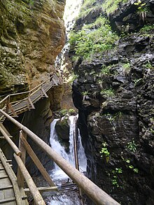
From Flattach the mountain may be climbed through the 200 m (660 ft) deep Ragga Ravine (Raggaschlucht), a protected natural monument, where a winding boardwalk leads across numerous waterfalls up to the Raggaalm pasture.
See also
Literature
- Manfred Posch: Reißeck, Kreuzeck. Die schönsten Touren, Klagenfurt, 2000, Kärntner Druck- und Verlagsgesellschaft m.b.H., ISBN 3-85391-176-5
На других языках
[de] Mölltaler Polinik
Der Mölltaler Polinik ist mit einer Höhe von 2784 m ü. A. der höchste Berg der Kreuzeckgruppe im österreichischen Bundesland Kärnten.- [en] Mölltaler Polinik
[it] Mölltaler Polinik
Il Mölltaler Polinik (2.784 m s.l.m.) è la montagna più alta del Gruppo del Kreuzeck nelle Alpi dei Tauri occidentali. Si trova in Carinzia.Текст в блоке "Читать" взят с сайта "Википедия" и доступен по лицензии Creative Commons Attribution-ShareAlike; в отдельных случаях могут действовать дополнительные условия.
Другой контент может иметь иную лицензию. Перед использованием материалов сайта WikiSort.org внимательно изучите правила лицензирования конкретных элементов наполнения сайта.
Другой контент может иметь иную лицензию. Перед использованием материалов сайта WikiSort.org внимательно изучите правила лицензирования конкретных элементов наполнения сайта.
2019-2025
WikiSort.org - проект по пересортировке и дополнению контента Википедии
WikiSort.org - проект по пересортировке и дополнению контента Википедии
