geo.wikisort.org - Mountains
The High Tauern (pl.; German: Hohe Tauern, Italian: Alti Tauri) are a mountain range on the main chain of the Central Eastern Alps, comprising the highest peaks east of the Brenner Pass. The crest forms the southern border of the Austrian states of Salzburg, Carinthia and East Tyrol, with a small part in the southwest belongs to the Italian province of South Tyrol. The range includes Austria's highest mountain, the Grossglockner at 3,798 metres (12,461 ft) above the Adriatic.
| High Tauern | |
|---|---|
 Panorama of the Venediger Group | |
| Highest point | |
| Peak | Grossglockner |
| Elevation | 3,798 m (12,461 ft) |
| Coordinates | 47°04′30″N 12°41′40″E |
| Dimensions | |
| Length | 130 km (81 mi) |
| Width | 50 km (31 mi) |
| Geography | |
 Location in the Alps | |
| Countries | Austria and Italy |
| States | Salzburg, Carinthia, Tyrol and South Tyrol |
| Range coordinates | 47°10′N 12°30′E |
| Parent range | Central Eastern Alps |
| Geology | |
| Orogeny | Alpine |
| Age of rock | Paleozoic |
| Type of rock | Gneiss and Schist |
In the east, the range is adjoined by the Lower Tauern. For the etymology of the name, see Tauern.
Geography
According to the Alpine Club classification of the Eastern Alps, the range is bounded by the Salzach valley to the north (separating it from the Kitzbühel Alps), the Mur valley and the Murtörl Pass to the east (separating it from the Lower Tauern), the Drava valley to the south (separating it from the Southern Limestone Alps), and the Birnlücke Pass to the west (separating it from the Zillertal Alps).
Its most important subgroups along the Alpine crest are (from West to East):

- Venediger Group (including Grossvenediger, 3,666 metres (12,028 ft), and Lasörling, 3,098 metres (10,164 ft))
- Granatspitze Group (Großer Muntanitz, 3,232 metres (10,604 ft), and Granatspitze, 3,086 metres (10,125 ft))
- Glockner Group (Grossglockner, 3,798 metres (12,461 ft))
- Goldberg Group (Hoher Sonnblick, 3,106 metres (10,190 ft))
- Ankogel Group (Hochalmspitze, 3,360 metres (11,020 ft), Ankogel, 3,246 metres (10,650 ft)) and Reisseck Group (Reisseck, 2,965 metres (9,728 ft))
The eastern end of the High Tauern is formed by the Hafner massif of the Ankogel Group, which includes the easternmost three-thousander peaks in the Alpine chain.
Further parts of the High Tauern south of the main crest of the Alps are (from West to East):
- Rieserferner Group (Hochgall, 3,436 metres (11,273 ft))
- Villgraten Mountains (Weiße Spitze, 2,962 metres (9,718 ft))
- Schober Group (including the Petzeck, 3,283 metres (10,771 ft) and Hochschober, 3,240 metres (10,630 ft))
- Kreuzeck Group (Mölltaler Polinik, 2,784 metres (9,134 ft))
High Tauern National Park

Along 100 kilometres (62 mi) of the main chain stretches the High Tauern National Park (Nationalpark Hohe Tauern), to which the Austrian Alpine Club as freeholder and the three states of Carinthia, Salzburg and Tyrol have contributed territory. With an area of about 1,834 square kilometres (708 sq mi), it is by far the largest of Austria's seven national parks as well as the largest nature reserve in the Alps.[1] It is divided into a core zone of 1,198 square kilometres (463 sq mi) including the Grossglockner and Grossvenediger massifs, with complete prohibition of agricultural use, and a fringe zone of 638 square kilometres (246 sq mi) used for forestry and alpine-meadow farming. Five special nature sanctuaries are protected from any human disturbance.
The park of the IUCN II category comprises the Pasterze and numerous further glaciers, the Krimml Waterfalls, several glacial valleys and alluvial fans, as well as extended tundra areas and forests. Among the flora of the Alps, especially Swiss Pines grow along the tree line; above subshrub, mainly alpenrose but also the endemic Saxifraga rudolphiana, up to nival level at about 2,800 m (9,200 ft). The fauna includes chamois, Alpine ibex and red deer, as well as griffon vulture and the golden eagle. The formerly extinct bearded vulture and the Alpine marmot have been successfully reintroduced.
The park was established according to a 1971 declaration signed by the participating states at Heiligenblut, it nevertheless took until 1981, when the first parts around Großglockner and Hochschober in Carinthia were put under protection. The adjacel finally joined in 1992. [[Touriut has become less harmful to the environment. A particular emphasis is pution and the maintenance of traditional ways of life in the Alps.
Peaks


The main peaks of the High Tauern are:
| Peak | Group | Elevation (m/ft) | Prominence (m/ft) | ||
|---|---|---|---|---|---|
| Großglockner | Glockner | 3798 | 12,461 | 2423 | 7,949 |
| Großvenediger | Venediger | 3666 | 12,028 | 1199 | 3,934 |
| Großes Wiesbachhorn | Glockner | 3564 | 11,693 | 477 | 1,565 |
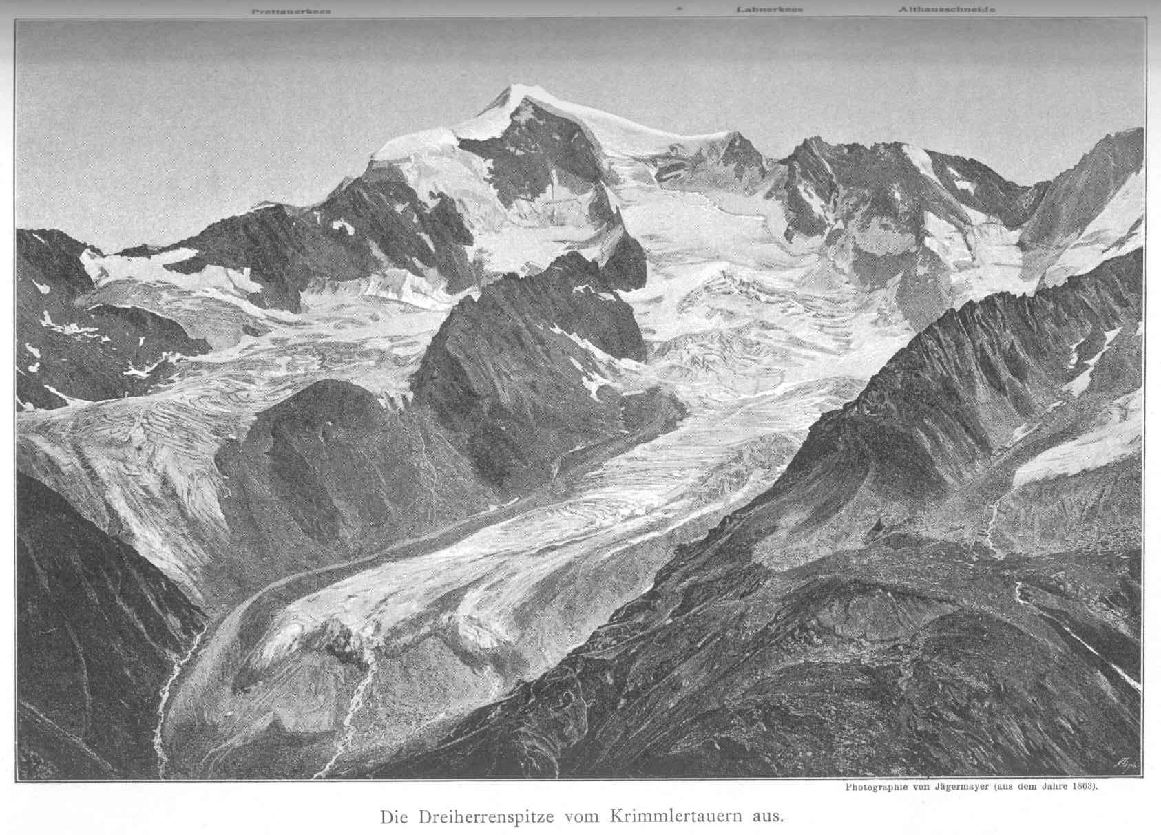
| Dreiherrnspitze | Venediger | 3499 | 11,480 | 591 | 1,939 |
| Rötspitze | Venediger | 3496 | 11,470 | 653 | 2,142 |
| Johannisberg | Glockner | 3453 | 11,329 | 277 | 909 |
| Hochgall | Rieserferner | 3436 | 11,273 | 1148 | 3,766 |
| Hoher Eichham | Venediger | 3371 | 11,060 | 325 | 1,066 |
| Hoher Tenn | Glockner | 3368 | 11,050 | 335 | 1,099 |
| Malhamspitze | Venediger | 3368 | 11,050 | 319 | 1,047 |
| Hochalmspitze | Ankogel | 3360 | 11,024 | 942 | 3,091 |
| Großer Geiger | Venediger | 3360 | 11,024 | 293 | 961 |
| Schneebiger Nock | Rieserferner | 3358 | 11,017 | 542 | 1,778 |
| Fuscherkarkopf | Glockner | 3331 | 10,928 | 489 | 1,604 |
| Keeskogel | Venediger | 3291 | 10,797 | 373 | 1,224 |
| Schlieferspitze | Venediger | 3290 | 10,794 | 513 | 1,683 |
| Petzeck | Schober | 3283 | 10,771 | 802 | 2,631 |
| Roter Knopf | Schober | 3281 | 10,764 | 556 | 1,824 |
| Ankogel | Ankogel | 3264 | 10,709 | 570 | 1,870 |
| Hocharn | Goldberg | 3254 | 10,676 | 678 | 2,224 |
| Großer Hornkopf | Schober | 3251 | 10,666 | 456 | 1,496 |
| Hohe Fürlegg | Venediger | 3243 | 10,640 | 385 | 1,263 |
| Hochschober | Schober | 3242 | 10,636 | 438 | 1,437 |
| Großer Muntanitz | Granatspitze | 3232 | 10,604 | 717 | 2,352 |
| Hocheiser | Glockner | 3206 | 10,518 | 577 | 1,893 |
| Glödis | Schober | 3206 | 10,518 | 370 | 1,214 |
| Kitzsteinhorn | Glockner | 3204 | 10,512 | 439 | 1,440 |
| Durreck | Venediger | 3135 | 10,285 | 626 | 2,054 |
| Hoher Sonnblick | Goldberg | 3106 | 10,196 | 271 | 889 |
| Lasörling | Venediger | 3098 | 10,164 | 490 | 1,608 |
| Großer Hafner | Hafner | 3068 | 10,066 | 868 | 2,848 |
| Hoher Prijakt | Schober | 3064 | 10,052 | 470 | 1,542 |
| Weisse Spitze | Villgraten | 2963 | 9,721 | 920 | 3,018 |
| Mölltaler Polinik | Kreuzeck | 2784 | 9,134 | 1580 | 5,184 |
Tunnels and passes
The High Tauern are crossed by three tunnels:
- Tauern Railway Tunnel between Bad Gastein and Mallnitz, finished in 1906
- Katschberg Tunnel on A10 Tauern Autobahn (European route E55) leading from Sankt Michael im Lungau and the Tauern Road Tunnel to Rennweg
- Felbertauerntunnel on B108 Felbertauern Straße highway, between Mittersill and Matrei in Osttirol
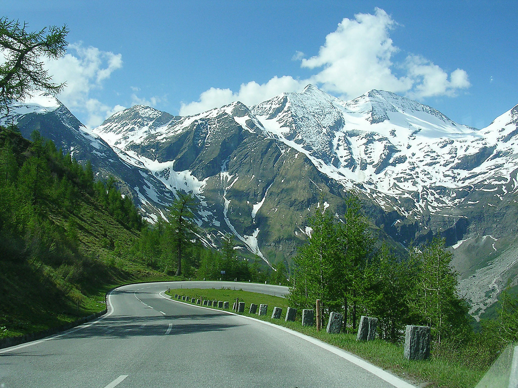
The best-known mountain pass road of the High Tauern is the scenic Grossglockner High Alpine Road inaugurated in 1935, including a tunnel at an elevation of 2,505 metres (8,219 ft) under the Hochtor Pass (2,573 metres (8,442 ft)). East of it, the Katschberg Pass (1,641 metres (5,384 ft)) on B 99 Katschberg Straße highway parallel to the Katschberg Tunnel links Sankt Michael and Rennweg. Another road crosses the Staller Sattel between Sankt Jakob in Defereggen and Rasen-Antholz at 2,052 metres (6,732 ft).
Beside there are numerous bridle and footpaths, in part used since ancient times:
| Mountain pass | Location | Type | Elevation (m/ft) | |
|---|---|---|---|---|
| Riffeltor | Kaprun to Heiligenblut | snow | 3051 | 10,010 |
| Bockkarscharte | Ferleiten to Heiligenblut | snow | 3046 | 9994 |
| Sonnblickscharte | Rauris to Heiligenblut | snow | 2979 | 9774 |
| Vörder Umbaltorl | Prägraten to Ahrntal | snow | 2928 | 9607 |
| Obersulzbachtorl | Prägraten to Wald im Pinzgau | snow | 2926 | 9600 |
| Untersulzbachtorl | Innergschlöß to Wald im Pinzgau | snow | 2865 | 9400 |
| Schwarzkopfscharte | Innergschlöß to Bramberg | snow | 2850 | 9351 |
| Prägratertorl | Prägraten to Defereggental | footpath | 2846 | 9338 |
| Glodistorl | Lienz to Kals | snow | 2832 | 9292 |
| Antholzerscharte | Rein in Taufers to Rasen-Antholz | snow | 2820 | 9252 |
| Krimmlertorl | Krimmler Achental to Obersulzbachtal | snow | 2814 | 9233 |
| Goldzechscharte | Rauris to Heiligenblut | snow | 2810 | 9220 |
| Kalsertorl | Lienz to Kals | snow | 2803 | 9197 |
| Ober Tramerscharte | Rauris to Döllach | snow | 2802 | 9193 |
| Kleine Elendscharte | Bad Gastein to Gmünd | snow | 2739 | 8987 |
| Kleine Zirknitzscharte | Rauris to Döllach | snow | 2719 | 8921 |
| Mallnitzerscharte | Mallnitz to Gmünd | snow | 2677 | 8783 |
| Große Elendscharte | Mallnitz to upper Maltatal | snow | 2673 | 8770 |
| Unter Pfandlscharte | Ferleiten to Heiligenblut | snow | 2665 | 8744 |
| Bergertorl | Ferleiten to Heiligenblut | footpath | 2650 | 8695 |
| Kaprunertorl | Kaprun to upper Stubachtal | snow | 2635 | 8645 |
| Virgner or Defereggertorl | Defereggental to Virgen | footpath | 2617 | 8586 |
| Backlenke or Trojerjoch | Defereggental to Prägraten | footpath | 2613 | 8573 |
| Felber Tauern | Matrei in Osttirol to Mittersill | bridle path | 2540 | 8334 |
| Kalser Tauern | Kals to Mittersill | footpath | 2512 | 8242 |
| Hohe Tauern | Bad Gastein to Mallnitz | bridle path | 2463 | 8081 |
| Niedere or Mallnitzer Tauern | Bad Gastein to Mallnitz | bridle path | 2414 | 7920 |
| Fuschertorl | Ferleiten to the Seidlwinkeltal | footpath | 2405 | 7891 |
| Klammljoch | Defereggental to Sand in Taufers | bridle path | 2291 | 7517 |
| Arlscharte | Gmünd to Sankt Johann im Pongau | footpath | 2251 | 7386 |
| Kals Matreiertorl | Kals to Matrei | bridle path | 2206 | 7238 |
| Stanz | Bad Gastein to Rauris | footpath | 2103 | 6900 |
See also
- Hohe Tauern window – Austrian Central Eastern Alps region with exposed Penninic nappes
- Lärchwandschrägaufzug
References
- The largest nature reserve of the Alps ... at www.hohetauern.at. Accessed on 10 Jul 2011.
External links
 Media related to Hohe Tauern at Wikimedia Commons
- Hohe Tauern National Park
- High Tauern on Hike.uno
Subgroups of the High Tauern according to the AVE (from west to east) | ||
|---|---|---|
| Main ridge |  | |
| Southern groups | ||
Mountain ranges of the Central Eastern Alps according to the AVE | ||
|---|---|---|
|  | |
Authority control | |
|---|---|
| General |
|
| National libraries | |
На других языках
[de] Hohe Tauern
Die Hohen Tauern sind eine Hochgebirgsregion der Zentralalpen in Österreich. Der rund 120 km lange und bis 3798 m ü. A. hohe Hauptkamm stellt die geografische Mitte der Ostalpen dar. Hier befinden sich – neben den Ötztaler Alpen – die höchsten Berge Österreichs. In der Hafnergruppe (ein Teil der Ankogelgruppe) liegen die östlichsten Dreitausender der Alpen.- [en] High Tauern
[es] Hohe Tauern
Hohe Tauern es la cordillera más grande de la zona central-este de los Alpes, ubicado en los montes de Brenner, que incluye algunas de las grandes montañas ubicadas en Austria. Esta cordillera está incluida dentro de las comunidades austriacas de Salzburgo, Carintia y el este de Tirol.[fr] Hohe Tauern
Les Hohe Tauern (en italien : Alti Tauri) sont un massif des Alpes orientales centrales. La crête principale, de 130 kilomètres de long, s’élève entre l’Autriche (le Land de Salzbourg, le Land de Carinthie et le Tyrol de l'Est) et l’Italie (la province autonome de Bolzano).[it] Alti Tauri
Gli Alti Tauri (Hohe Tauern in tedesco) sono una sottosezione[1] delle Alpi dei Tauri occidentali, poste in Austria (Tirolo, Salisburghese e Carinzia) ed in minima parte in Italia (Provincia autonoma di Bolzano). La vetta più alta è il Großglockner che raggiunge i 3.798 m s.l.m., con buona parte del territorio degli che è protetto dal Parco nazionale Alti Tauri.[ru] Высокий Тауэрн
Высо́кий Та́уэрн[2][3] (нем. Hohe Tauern) — горы в Австрии, в системе Центральных Восточных Альп.Другой контент может иметь иную лицензию. Перед использованием материалов сайта WikiSort.org внимательно изучите правила лицензирования конкретных элементов наполнения сайта.
WikiSort.org - проект по пересортировке и дополнению контента Википедии