geo.wikisort.org - Mountains
The Lower Tauern[1][2][3] or Niedere Tauern (Slovene: Nizke Ture) are a mountain range of the Central Eastern Alps, in the Austrian states of Salzburg and Styria.
| Lower Tauern | |
|---|---|
 Hochgolling | |
| Highest point | |
| Peak | Hochgolling |
| Elevation | 2,863 m (9,393 ft) |
| Coordinates | 47°16′0″N 13°45′42″E |
| Naming | |
| Native name | Niedere Tauern (German) |
| Geography | |
 Location within the Eastern Alps
| |
| Country | Austria |
| States | Salzburg and Styria |
| Range coordinates | 47°18′N 14°0′E |
| Parent range | Central Eastern Alps |
| Borders on | Western Tauern Alps, Northern Salzburg Alps, Salzkammergut and Upper Austria Alps, Northern Styrian Alps, Styrian Prealps and Carinthian-Styrian Alps |
| Geology | |
| Orogeny | Alpine orogeny |
For the etymology of the name, see Tauern.
Geography
The range forms a part of the main chain of the Alps. The highest peak of the Lower Tauern is the Hochgolling, part of the Schladming Tauern, at 2,863 m (9,393 ft).
Important mountain pass roads include Radstädter Tauern Pass (1,738 m (5,702 ft)), Sölk Pass (1,788 m (5,866 ft)), and Triebener Tauern Pass (1,274 m (4,180 ft)). The range is also crossed by the Tauern Autobahn (A10) through the Tauern Road Tunnel.
Borders
In the west and south the Murtörl mountain pass and the River Mur separate them from the Hohe Tauern mountain range, while in the east and north the River Enns and the Schober Pass marks the border to the Northern Limestone Alps.
Alpine Club classification
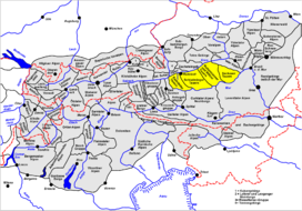
According to the Alpine Club classification of the Eastern Alps, the Lower Tauern may be divided into four subgroups (from west to east):
- Radstadt Tauern (45a)
- Schladming Tauern (45b)
- Rottenmann and Wölz Tauern (45c)
- Seckau Tauern (45d).
The four groups listed above (the Radstadt Tauern, Schladming Tauern, Rottenmann and Wölz Tauern and Seckau Alps) are considered Alpine subsections.
Notable summits

Some notable summits of the range are:
| Name | elevation (m) | subsection |
|---|---|---|
| Hochgolling | 2,862 | Schladming Tauern |
| Weißeck | 2,711 | Radstadt Tauern |
| Mosermandl | 2,680 | Radstadt Tauern |
| Hochfeind | 2,687 | Radstadt Tauern |
| Großes Gurpitscheck | 2,526 | Schladming Tauern |
| Hundstein | 2,614 | Schladming Tauern |
| Hochwildstelle | 2,747 | Schladming Tauern |
| Roteck | 2,742 | Schladming Tauern |
| Großer Knallstein | 2,599 | Schladming Tauern |
| Rettlkirchspitze | 2,475 | Rottenmann and Wölz Tauern |
| Großer Bösenstein | 2,425 | Rottenmann and Wölz Tauern |
| Geierhaupt | 2,417 | Seckau Tauern |
| Hochreichhart | 2,416 | Seckau Tauern |
| Seckauer Zinken | 2,389 | Seckau Tauern |
| Maierangerkogel | 2,356 | Seckau Tauern |
Geology and environment
The Lower Tauern mark the approximate eastern limit of the continuous ice sheet in the Alps during the Würm glaciation. Eastern parts of the group were therefore unglaciated, and served as an important refugium for silicicolous plants.
Winter sports
A number of skiing resorts are situated in the Lower Tauern, including Obertauern and Schladming.
References
- Bourne, Grant and Körner-Bourne, Sabine (2007). Walking in the Bavarian Alps, 2nd ed., Cicerone, Milnthorpe, p. 303. ISBN 978-1-85284-497-4.
- Jeep, John M. Medieval Germany: An Encyclopedia, New York and London: Garland, 2001, p. 716.
- The New Encyclopædia Britannica, Vol. 1, 2003, p. 86.
External links
Mountain ranges of the Central Eastern Alps according to the AVE | ||
|---|---|---|
|  | |
Authority control | |
|---|---|
| General |
|
| National libraries | |
На других языках
[de] Niedere Tauern
Die Niederen Tauern sind eine Großgruppe der Zentralalpen in den Ostalpen. Sie schließen östlich an die Hohen Tauern an. Die Gebirgsgruppe befindet sich in Österreich in den Bundesländern Salzburg und Steiermark.- [en] Lower Tauern
[fr] Niedere Tauern
Les Niedere Tauern sont un massif des Alpes orientales centrales qui s'élève en Autriche à cheval entre le land de Salzbourg et la Styrie. Appartenant aux Alpes noriques, il culmine à 2 862 m au Hochgolling.[it] Alpi dei Tauri orientali
Le Alpi dei Tauri orientali (detti anche Bassi Tauri - in tedesco Niedere Tauern) sono una sezione[1] delle Alpi. Si trovano nelle Alpi Centro-orientali. Si estendono esclusivamente in Austria, nei Länder del Salisburghese e della Stiria. La vetta più alta è l'Hochgolling che raggiunge i 2.863 m s.l.m.[ru] Низкий Тауэрн
Ни́зкий Та́уэрн[2][3] (нем. Niedere Tauern) — горный хребет в Центральных Восточных Альпах (Австрия). Его длина составляет более 100 км. Самая высокая точка — гора Хохголлинг (2862 м). Расположен на главном альпийском хребте, на территории земель Штирия и Зальцбург. На западе и юге граница с хребтом Высокий Тауэрн проходит по перевалу Муртёрль и реке Мур, а на севере и востоке река Энс и перевал Шобер определяют границу с Северными Известняковыми Альпами.Другой контент может иметь иную лицензию. Перед использованием материалов сайта WikiSort.org внимательно изучите правила лицензирования конкретных элементов наполнения сайта.
WikiSort.org - проект по пересортировке и дополнению контента Википедии