geo.wikisort.org - Mountains
The Sarntal Alps (German: Sarntaler Alpen, Italian: Alpi Sarentine) are a mountain range of the Eastern Rhaetian Alps, in South Tyrol (Italy), which surrounds the Sarntal (valley). It is limited by the Etschtal, Eisacktal, Passeiertal and the Jaufen Pass.[1]
| Sarntal Alps | |
|---|---|
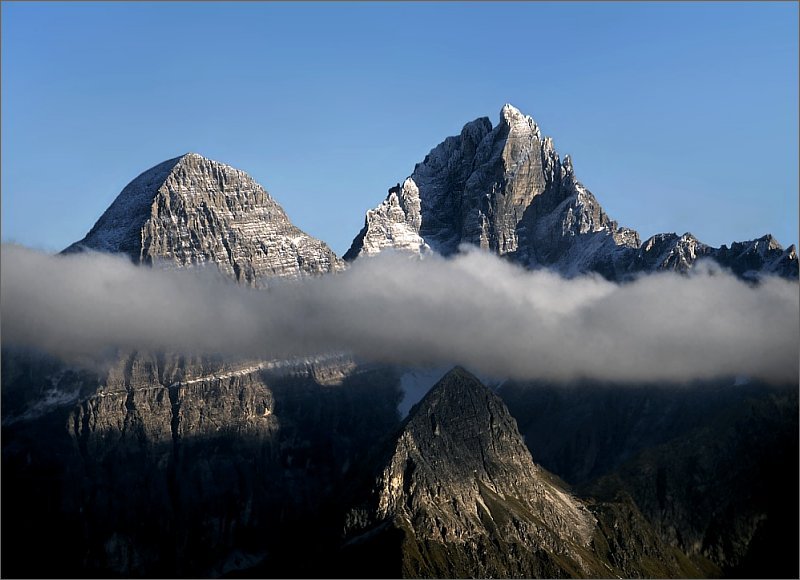
 The Sarntal east ridge rarely forms rugged peaks, in the picture: Ritzlar, 2528 m. | |
| Highest point | |
| Peak | Hirzer (Sarntal Alps) |
| Elevation | 2,781 m (9,124 ft) |
| Coordinates | 46°44′13″N 11°16′35″E |
| Geography | |
| Country | Italy |
| State | South Tyrol |
| Parent range | Eastern Rhaetian Alps, Central Eastern Alps |
Topography
The Sarntal Alps are divided into an Eastern and a Western Part, which meet at the Penser Joch. The Eastern Part has got various minor ridges.
Eastern Part
The Southern half (south to Kassianspitze) is compared to the surrounding ranges not that elevated, its highest peaks are Villanderer Berg (2509m) and Rittner Horn (2260m), further south it becomes the Ritten.[1]
The northern has got the Tatschspitze (2528m), Tagewaldhorn (2708m), Jakobsspitze (2742m), Schrotthorn (2590m), Plankenhorn (2543m) Kassianspitze (2581m).[2]
The biggest minor ridge of the Sarntal Alps is the Middle Ridge, beginning at the Hörtlanerspitze (2660m),[3] it limites the Durnholztal. Its most known peaks are Gentersbergspitze (2411m), Hoferspitze (2438m) and Leiterspitze (2375m), which is its last peak. The other minor ridge to the west is the Getrumkamm, with its peaks Plankenhorn (2589 m) and Getrumspitze.[2]
The minor ridges on the Eisack side are due to Flaggertal and Schalderer Tal. Limited to the north by Flaggertal and to the south by Schalderer Tal exists a ridge with Karspitze (2517m) as its highest peak and limited to the north by Schalderer Tal exists a ridge with Lorenzispitze (2483m) and Königsangerspitze (2439m).[2]
Western Part

The southern half is not that elevated, it is called Tschöggelberg.[1]
Its middle part consists of the highest mountains, that among the Hirzer (2781m), Alplerspitze (2750m), Hönigsspitze (2698m) and Plattinger Spitze (2670m). More to the west, there is the Ifinger.[2]
The most notable mountains of the northern part are the Penser Weißhorn (2705 m), Zinseler (2422m), Jaufenspitze (2481m), Hochwart (2748m) and Ötsch (2592m).[2]
Sights
The churchhouse Latzfonser Kreuz is one of the highest located (2,311m) places of pilgrimage in South Tyrol.
At the southern side the Ritten, the natural phenomenum of hoodoo can be seen.[1]
References
- "Sarntaler Alpen - Südtirol". suedtirolerland.it (in German). Retrieved 2019-03-18.
- Hofer, Tom. "Sarntaler Alpen: Große Karte mit den Grenzen und Hütten, Gipfeln sowie Touren der Gebirgsgruppe". Deine Berge - Hütten, Touren, Gipfel (in German). Retrieved 2019-03-18.
- Sarntaler Alpen = Monti Sarentini., Tabacco, 2013, ISBN 9788883150548, OCLC 908150134
External links
![]() Media related to Sarntal Alps at Wikimedia Commons
Media related to Sarntal Alps at Wikimedia Commons
Mountain ranges of the Central Eastern Alps according to the AVE | ||
|---|---|---|
|  | |
| Authority control: National libraries |
|---|
This Italian location article is a stub. You can help Wikipedia by expanding it. |
На других языках
[de] Sarntaler Alpen
Die Sarntaler Alpen (italienisch Alpi Sarentine) sind eine Gebirgsgruppe in Südtirol (Italien). Der Gebirgszug ist umgrenzt von Etschtal, Eisacktal, Wipptal, Jaufental, Waltental und Passeier. Das Sarntal, das im Norden am durch eine Straßenverbindung erschlossenen Penser Joch (2215 m s.l.m.) endet, teilt die Gebirgsgruppe in einen westlichen und östlichen Teil. Vor allem die nördlichen Gebiete der Gebirgsgruppe sind für Südtiroler Verhältnisse touristisch vergleichsweise wenig erschlossen und daher nicht so überlaufen.- [en] Sarntal Alps
[fr] Alpes sarentines
Les Alpes sarentines (italien : Alpi Sarentine) ou Alpes de Sarntal (allemand : Sarntaler Alpen) sont un massif des Alpes orientales centrales. Elles s'élèvent en Italie (province de Bolzano), entre les rives de l'Adige et de l'Isarco. Une autre vallée, la vallée de Sarentino ou Sarntal, qui s'écoule au cœur du massif vers le sud, lui donne son nom.[it] Alpi Sarentine
Le Alpi Sarentine (Sarntaler Alpen in tedesco) sono un gruppo montuoso delle Alpi Retiche orientali. Si trovano nella Provincia autonoma di Bolzano a nord della città di Bolzano e tra i fiumi Adige ed Isarco. Sarentino e la valle omonima percorsa dal torrente Talvera si trovano al centro del gruppo montuoso.Другой контент может иметь иную лицензию. Перед использованием материалов сайта WikiSort.org внимательно изучите правила лицензирования конкретных элементов наполнения сайта.
WikiSort.org - проект по пересортировке и дополнению контента Википедии