geo.wikisort.org - Mountains
The Großes Wiesbachhorn (German pronunciation: [ˈɡʀoːsəs ˈviːsbaχˌhɔʁn] (![]() listen)) is a mountain in the federal state of Salzburg, Austria and, at 3,564 m above sea level (AA) (according to other sources 3,570 m above sea level (AA)), is the third-highest peak of the Hohe Tauern range.
listen)) is a mountain in the federal state of Salzburg, Austria and, at 3,564 m above sea level (AA) (according to other sources 3,570 m above sea level (AA)), is the third-highest peak of the Hohe Tauern range.
| Großes Wiesbachhorn | |
|---|---|
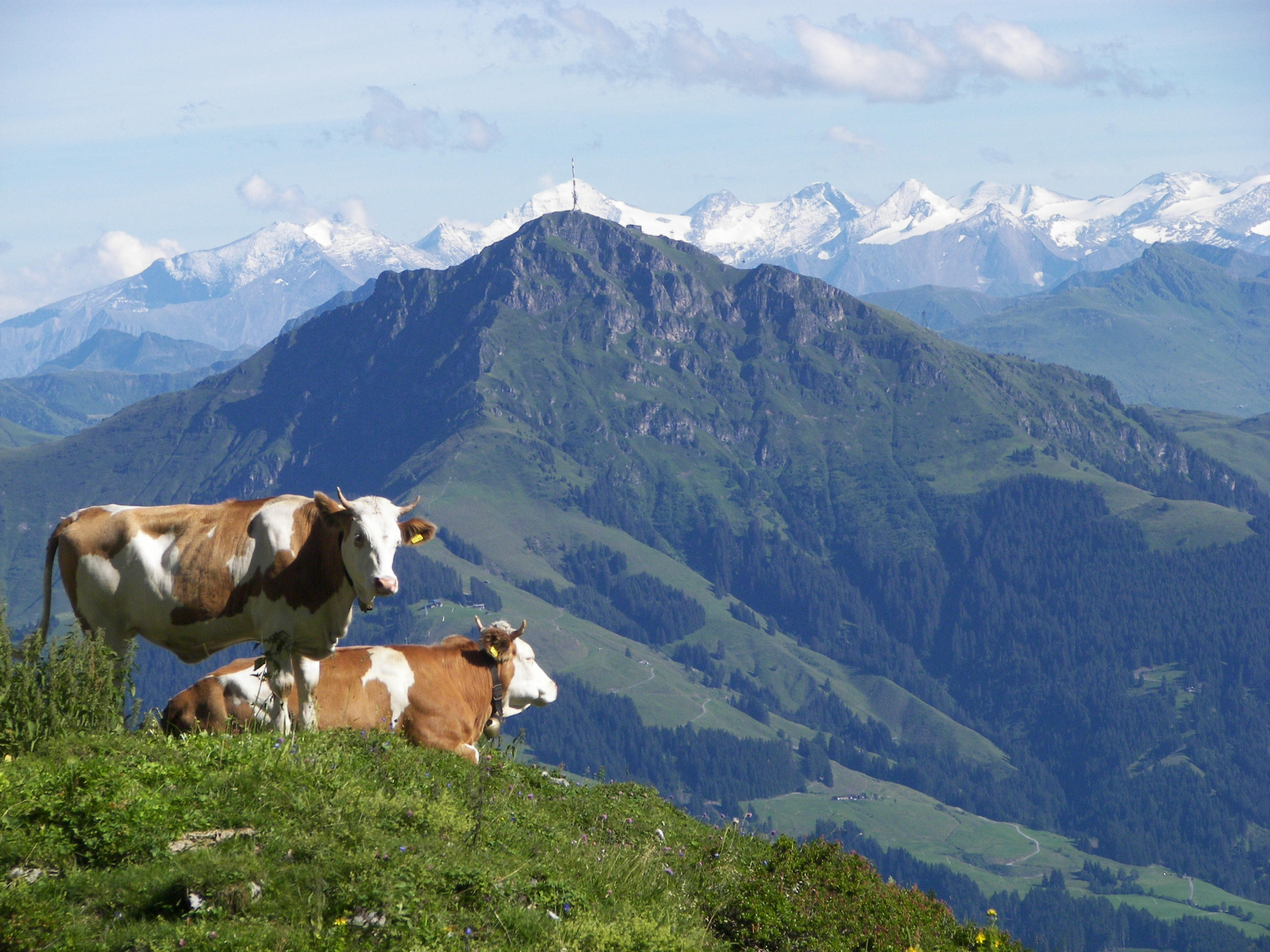
 The Großes Wiesbachhorn seen from the start of the Großglockner Alpine Road | |
| Highest point | |
| Elevation | 3,564 m (11,693 ft) |
| Prominence | 450 m (1,480 ft) |
| Isolation | 9.7 km (6.0 mi) |
| Listing | Alpine mountains above 3000 m |
| Coordinates | 47°9′25″N 12°45′18″E |
| Geography | |
| Location | Salzburg, Austria |
| Parent range | Hohe Tauern |
| Climbing | |
| First ascent | In the 18th century by two farmers from Fusch called Zanker and Zorner[1] |
| Easiest route | Over the northwest ridge (Kaindlgrat, I, Firnschneide 35°) |

Its entirely free-standing firn-capped summit forms the main peak of the Fusch/Kaprun chain and is often viewed in Alpine literature as a rival of the Großglockner. The great slope on its eastern and southeastern side plunges about 2,300 metres to the Fuscher Ache - one of the greatest height differences between mountaintop and valley floor in the Eastern Alps. Of alpinistic significance was the first ascent of the Northwest Face (Nordwestwand) on 15 July 1924 by Franz Riegele and Willo Welzenbach. They were the first ones to use ice nails (Eisnägel) to assist them; these were later developed into the ice screws used today. The Northwest Face was one of the classic ice walls of the Eastern Alps; the ice has since melted, however.
Location and area
The Großes Wiesbachhorn is almost entirely surrounded by glaciers. To the north is the Wielingerkees, to the northeast the Sandbodenkees flows eastwards and down into the Sandboden and further into the Fuscher Ache. To the south lies the Teufelsmühlkees und im Westen das Kaindlkees. An important neighbouring mountain to the north, separated by the 3,211-metre-high wind gap of the Sandbodenscharte, is the Kleines Wiesbachhorn with a height of 3,286 metres. To the southwest, on the other side of the 3,265-metre-high Wielingerscharte, between the Kaindlkees and Teufelsmühlkees glaciers, lies the two Bratschenköpfe peaks (3,413 and 3,401 metres high). To the west the terrain falls away to the Mooserboden Reservoir, to the east into the Fuscher Tal. The nearest important settlement is Fusch an der Großglocknerstraße, about 10 kilometres away to the north as the crow flies.
Ascents
The route originally used by the Fusch farmers at the end of the 18th century is rarely used today. It runs from Ferleiten and takes 3½ hours to reach the Schwarzenberg Hut and from there another 4 hours past the Bratschenköpfe peaks to the summit of the Horn.[2] The usual present-day start point for ascents is the Heinrich Schwaiger Haus. From there the standard route runs over the Oberen Fochezkopf and along the Kaindlgrat ridge to the summit in about 3 hours. In the middle section of the route there is a 35° inclined firn edge (Firnschneide), the rock sections are rated at climbing grade UIAA I. The classic routes through the 500-metre-high Nordwest Face required ice climbing skills capable of coping with up to 60° gradients.[3]
 Wiesbachhorn Group, from the north over the Kitzbüheler Horn
 The top of the Großes Wiesbachhorn is over 2,400 metres above the valley of the Fuscher Ache

See also
List of highest mountains of Austria
Sources and maps
- Willi End: Alpine Club Guide Glocknergruppe, Bergverlag Rother, Munich, 2003, ISBN 3-7633-1266-8
- Eduard Richter: Die Erschliessung der Ostalpen, Vol III, Verlag des Deutschen und Oestereichischen Alpenvereins, Berlin 1894
- Alpine Club map 1:25.000, Sheet 40, Glocknergruppe
References
- Carl Ehrenbert Freiherr von Moll: Molls Jahrbuch für Berg- und Hüttenkunde, Vol. V, Salzburg 1801, p. 241
- Eduard Richter: Die Erschliessung der Ostalpen, Vol III, Berlin 1894, p. 208 ff.
- Willi End: Alpenvereinsführer Glocknergruppe, Munich, 2003, p. 434 ff., Rz 1590 ff.
На других языках
[de] Großes Wiesbachhorn
Das Große Wiesbachhorn ist mit einer Höhe von 3564 m ü. A.[4] das zweithöchste Bergmassiv der Glocknergruppe und liegt im Bundesland Salzburg in Österreich. Der vollkommen freistehende Firndom bildet den Hauptgipfel des Fuscher/Kapruner Kammes und wird in alpinistischer Literatur oft als Rivale zum Großglockner gesehen. Der tiefe Absturz gegen Osten und Südosten weist mit über 2400 m einen der größten Höhenunterschiede zwischen Tal und Gipfel in den Ostalpen auf. Von alpinistischer Bedeutung war die Erstbegehung der Nordwestwand am 15. Juli 1924 durch Franz Riegele und Willo Welzenbach. Sie verwendeten zur Fortbewegung am sogenannten Eiswulst zum ersten Mal Eishaken, die später zu Eisschrauben weiterentwickelt wurden. Die Nordwestwand war eine der klassischen Eiswände der Ostalpen; mittlerweile ist das Eis jedoch völlig abgeschmolzen.- [en] Großes Wiesbachhorn
[fr] Grosses Wiesbachhorn
Le Grosses Wiesbachhorn (ou Großes Wiesbachhorn) est un sommet des Alpes, à 3 564 m d'altitude, dans les Hohe Tauern, et plus particulièrement dans le chaînon de Glockner, en Autriche (land de Salzbourg).Другой контент может иметь иную лицензию. Перед использованием материалов сайта WikiSort.org внимательно изучите правила лицензирования конкретных элементов наполнения сайта.
WikiSort.org - проект по пересортировке и дополнению контента Википедии