geo.wikisort.org - Mountains
Shkhara (Georgian: შხარა) is the highest point in the nation of Georgia[4] It is located near the Russian-Georgian border, in Russia's Kabardino-Balkaria region on the northern side, and the Svaneti region of Georgia in the south. Shkhara lies 88 kilometres (55 mi) north of the city of Kutaisi, Georgia's second-largest city, and closer to the townlet of Mestia in Svaneti. The summit lies in the central part of the Greater Caucasus Mountain Range, to the south-east of Mount Elbrus, Europe's highest mountain. Shkhara is the third-highest peak in the Caucasus, just behind Dykh-Tau.[5]
| Shkhara | |
|---|---|
 | |
| Highest point | |
| Elevation | 5,193 m (17,037 ft)[1] |
| Prominence | 1,357 m (4,452 ft) |
| Isolation | 6 km (3.7 mi) |
| Listing |
|
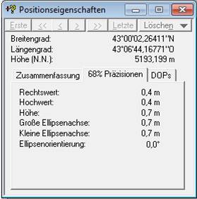
| Coordinates | 43°00′02″N 43°06′44″E |
| Geography | |
Shkhara Location of Shkhara within the Caucasus mountains 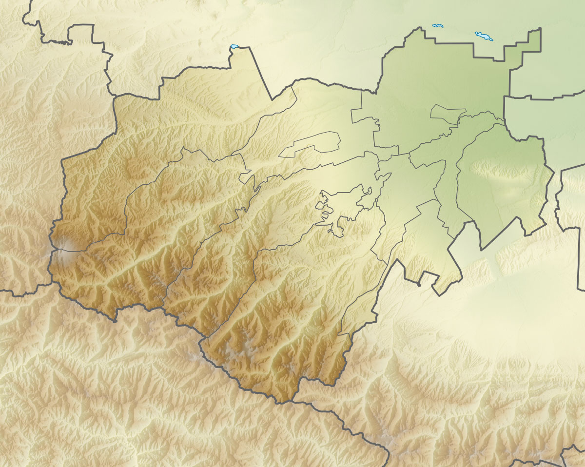 Shkhara Shkhara (Kabardino-Balkaria)  Shkhara Shkhara (Samegrelo-Zemo Svaneti) | |
| Location | Svaneti region, Georgia Shkhara |
| Country | Georgia |
| Parent range | Main Caucasian Range Greater Caucasus Mountains |
| Climbing | |
| First ascent | 1888 by U. Almer, J. Cockin and C. Roth[2] |
| Easiest route | Northeast Ridge: snow/ice climb (Russian grade 4b)[3][2] |
Morphology
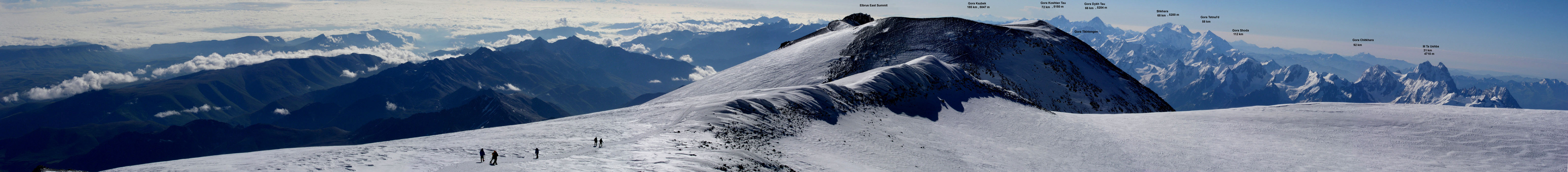
Shkhara is the high point and the eastern anchor of a massif known as the Bezingi (or Bezengi) Wall, a 12-kilometre-long (7.5 mi) ridge. It is a large, steep peak in a heavily glaciated region, and presents serious challenges to mountaineers. Its north face (on the Russian side) is 1,500 metres (4,900 ft) high and contains several classic difficult routes. The significant sub-summit Shkhara West, at 5,068 m (16,627 ft), is a climbing objective in its own right, and a traverse of the entire Bezingi Wall is considered "Europe's longest, most arduous, and most committing expedition".[2]
History
The peak was first climbed in 1888 via the North East Ridge route, by the British/Swiss team of English climber John Garford Cockin and Swiss guides Ulrich Almer and Christian Roth.[6] This route is still one of the easier and more popular routes on the mountain. The first complete traverse of the Bezingi Wall was in 1931, by the Austrians K. Poppinger, K. Moldan, and S. Schintlmeister.[citation needed]
See also
- List of mountains in Georgia
- List of elevation extremes by country
References
- The elevation and coordinates given here are taken from a DGPS survey by Peter Schoen and Boris Avdeev in association with GeoAT. It was carried out in July 2010 and made available in November 2010. Some sources, including the Great Soviet Encyclopedia, give the estimation of only 5,068 metres (16,627 feet), but this is the correct height of the lower western summit. Soviet era 1:50,000 mapping shows a 5,158-metre spot height to the east, and this can be verified using a panoramic photograph taken from Elbrus. The true elevation is on higher ground still further east along the Shkhara ridge.
- Audrey Salkeld, ed. (1998). World Mountaineering. Bulfinch Press. p. 70. ISBN 0-8212-2502-2.
- Shkhara on Summitpost
- "Shkhara - Peakbagger.com". www.peakbagger.com. Retrieved 2019-04-13.
- Shkhara. Weather Forecast, Georgia mountain-forecast.com
- J. G. Cockin, « Shkara, Janga, and Ushba », The Alpine Journal, vol. XVI, n° 122, novembre 1893, pp. 477-494 - reproduced in Douglas W. Freshfield, The exploration of Caucasus, E. Arnold, 1896, Volume II, pp. 38-58
На других языках
[de] Schchara
Der Schchara (georgisch შხარა; russisch Шхара) gilt mit 5201 m als höchster Berg Georgiens und dritthöchster Berg des Großen Kaukasus. Er liegt im Hauptkamm des Großen Kaukasus, der die Grenze zwischen Georgien und Russland bildet.- [en] Shkhara
[es] Shjara
El monte Shjara (Shkhara en transcripción al inglés), de 5193 m de altitud, es el tercer pico más alto de las montañas del Cáucaso y el punto más alto de Georgia. Se encuentra en la región de Svanetia a lo largo de la frontera con Rusia, a 88 km al norte de la ciudad de Kutaisi, la segunda ciudad de Georgia. La cumbre se encuentra en la parte central de la cadena del Gran Cáucaso, al sureste del monte Elbrús.[fr] Chkhara
Le Chkhara (შხარა en géorgien, Шхара en russe) est une montagne du Grand Caucase sur la frontière entre la Géorgie et la Russie. À une altitude de 5 203 m, il est le point culminant de la Géorgie, et le troisième sommet le plus élevé de Russie et du continent européen. Située à l'extrémité orientale de la muraille de Bezengui, la montagne fait partie de la chaîne du Grand Caucase central.[it] Shkhara
Shkhara è la montagna più alta della Georgia con 5200 metri e fa parte della catena del Caucaso.[ru] Шхара
Шха́ра (карач.-балк. ушхара, груз. შხარა — «Полосатая») — горная вершина в центральной части Главного Кавказского (Водораздельного) хребта, является его высочайшей точкой, также высочайшая точка Грузии. Высота главной вершины — 5193,2 м, уточнена в 2010 году альпинистами Питером Шоном и Борисом Авдеевым с помощью приемника DGPS[2], в некоторых источниках так же встречается высота 5203 м. В массиве Шхары, также выделяют западную вершину — 5068,8 м (42°59′57″ N, 43°05′23″E)[3] (на картах генштаба[4] она ошибочно обозначена как главная) и восточную вершину — 4866,5 м (43°00′12″ N, 43°07′39″E).Другой контент может иметь иную лицензию. Перед использованием материалов сайта WikiSort.org внимательно изучите правила лицензирования конкретных элементов наполнения сайта.
WikiSort.org - проект по пересортировке и дополнению контента Википедии