geo.wikisort.org - Mountains
Midžor (Serbian Cyrillic: Миџор, pronounced [mîdʒɔr]) or Midzhur (Bulgarian: Миджур, pronounced [miˈd͡ʒur]) is a peak in the Balkan Mountains, situated on the border between Bulgaria and Serbia. At 2,169 metres (7,116 ft), it is the highest peak of the Western Balkan Mountains, as well as the highest of Serbia outside Kosovo.[note 1]
| Midžor | |
|---|---|
| Midžor Миџор (in Serbian) • Midzhur Миджур (in Bulgarian) | |
 Picture taken from the Serbian side | |
| Highest point | |
| Elevation | 2,169 m (7,116 ft) |
| Prominence | 1,478 m (4,849 ft) |
| Coordinates | 43°23′38″N 22°40′54″E |
| Naming | |
| Language of name | Bulgarian, Serbian |
| Geography | |
 Midžor Location of Midžor on the border between Bulgaria and Serbia  Midžor Midžor (Bulgaria) | |
| Location | Bulgaria, Serbia |
| Parent range | Balkan Mountains |
Bulgaria
In Bulgaria, the peak is called Midzhur.
Since the early 1990s, it has been accessible to tourists from both sides; previously, access was forbidden due to the peak being in the border area. Due to those restrictions, the nature around the peak has been preserved untouched. On the Bulgarian side, the peak is reachable from the villages of Chuprene and Gorni Lom in Vidin Province.
Chuprene
From Chuprene there are two possibilities for climbing. There is a 17 km dirt road following the river Chprenska to the Gorski Ray refuge (1,450 m) or a 9 km foot track following the river Manastirska.
From the refuge there is a marked track which passes through the Chuprene biosphere reserve and leads to the main summit on a saddle between the peaks Replyanska Tsarkva (1,969 m) and Ostra Chuka (1967 m). To the south east through the peaks Ostra Chuka and Oba (2,033 m) the track reaches a saddle from where the Lom River and the Timok flow out at border stone 336. From there the peak can be climbed from the north-western slope.
Gorni Lom
At 7 km from the village of Gorni Lom is located the Gorni Lom refuge (840 m). There is also another refuge upstream called Mudzhur. There are steep tracks from there leading to the saddle between Oba and the peak at border stone 336 from where both tracks from the two villages merge.
Economy
The source of the Lom River is at the foot of the peak. A cascade of small hydroelectric power plants is in operation on the river near the peak and four more are under construction.[1] Chuprene biosphere reserve which is under the protection of UNESCO is situated to the west of the peak. It is one of the last sanctuaries in Bulgaria where the Capercaillie nests.
A special permission from a border police office (such as the ones in Sofia, Dragoman, Chiprovtsi, etc.) is required in order to ascend to the peak.
Serbia
In Serbia the peak is known as Midžor.
The extreme peak of the western mountain is north of the village of Topli Dol, located in the centre of Serbian Stara Planina, between Tri Čuke (1936 m) on the SE side and Babin Zub (1758 m) on the SW side. The massif of the Midžor peak is substantial. Its western, eastern, and southern slopes are grassy and not so steep, while its northern side is rocky and very steep. This side is also the most attractive and very popular among rock climbers.
It is the highest peak in Serbia outside of Kosovo, and the 24th highest in the whole of Serbia if Kosovo is included.[note 2]
There is a hotel called "Babin Zub" on the slopes. There are no fees or permits needed to enter the Serbian Stara Planina.[2]
Gallery
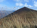 Peak
Peak Trail to the summit
 Border stone
 Sky and water
 Clouds


See also
- Midzhur Peak in Antarctica, named after Midzhur mountain
Footnotes
- Notes
- The highest peak of Serbia is officially Velika Rudoka in the Šar mountain range at 2,658 metres (8,720 ft), but it is located in Kosovo. If Kosovo is not included, then Midžor is the highest peak of Serbia.
The political status of Kosovo is disputed. Having unilaterally declared independence from Serbia in 2008, Kosovo is formally recognised as an independent state by 100 UN member states (with another 13 states recognising it at some point but then withdrawing their recognition) and 93 states not recognizing it, while Serbia continues to claim it as part of its own sovereign territory. - See: List of mountains in Serbia#Peaks over 2000 meters
- References
- Balabanov, G. (2005). This is Bulgaria (in Bulgarian and English). Sofia. p. 51. ISBN 954-91672-1-6.
- Midžor
External links
- Midžor on Summit post
- The Bulgarian side of Midžor
- Peakbagger link
- Video of a hike to the top of Midžor from The Armchair Mountaineer
На других языках
[de] Midschur
Der Midschur, Midžor oder Midzhur (bulgarisch Миджур, oder serbisch in kyrillischer Schrift Миџор) ist ein Berg, der im westlichen Teil des Balkangebirges (Stara Planina), an der serbisch-bulgarischen Staatsgrenze, liegt. Mit 2169 m Höhe ist er seit der Unabhängigkeit des Kosovo der höchste Berg in Serbien.- [en] Midžor
[es] Midžor
El Midžor (serbio: Миџор) o Midzhur (búlgaro: Миджур) es un pico en los Montes Balcanes, situado en la frontera entre Serbia y Bulgaria. Con una altitud de 2.169 msnm, es el pico más alto de los Balcanes occidentales, así como de Serbia excluyendo los situados en Kosovo. Es el nº 12 por elevación de la cordillera balcánica.[fr] Midžor
Le mont Midžor, en serbe cyrillique Миџор (Midjor) et en bulgare Миджур (Midjour), est le plus haut sommet de la partie serbe du Grand Balkan. Avec une altitude de 2 169 m, il est le sommet le plus élevé de Serbie en dehors du Kosovo dont l'indépendance n'est pas reconnue par la Serbie. Il forme une frontière naturelle entre la Serbie et la Bulgarie.[it] Midžor
Midžor (in serbo: Миџор?; in bulgaro: Миджур?) è una montagna alta 2.169 m s.l.m.. Si trova nei Monti Balcani sul confine tra Serbia e Bulgaria. Costituisce la cima serba più elevata, se non si considera il territorio del Kosovo.[ru] Миджур
Миджу́р[2][1][3], или Ми́джор[2] (серб. Миџор, болг. Миджур) — гора на границе Сербии и Болгарии[1], высочайшая вершина Восточно-Сербских гор[3] (запад гор Стара-Планина (Балканские горы), горный массив Чипровска-Планина). Высота — 2168 м[1], Миджур считают самой высокой горой в Центральной Сербии, хотя гора расположена на границе двух стран (община Чупрене в Видинской области Болгарии, неподалёку от села Горни-Лом и территории сербской общины Княжевац).Другой контент может иметь иную лицензию. Перед использованием материалов сайта WikiSort.org внимательно изучите правила лицензирования конкретных элементов наполнения сайта.
WikiSort.org - проект по пересортировке и дополнению контента Википедии