geo.wikisort.org - Mountains
Halti (Finnish: Halti, rarely Haltiatunturi, Northern Sami: Háldičohkka, Swedish: Haldefjäll) is a fell at the border between Norway and Finland. The peak (elevation 1,365 m (4,478 ft)) of the fell, called Ráisduattarháldi, is in Norway, on the border between the municipalities of Nordreisa and Gáivuotna–Kåfjord, about one kilometre (5⁄8 mile) north of the border with Finland.[2] The highest point of the fell on the Finnish side is at 1,324 m (4,344 ft) above sea level, and thus the highest point in the country. The Finnish side of Halti belongs to the municipality of Enontekiö in the province of Lapland.
| Halti | |
|---|---|
| (the mountain peak) | |
 Halti Location of the mountain  Halti Halti (Lapland)  Halti Halti (Norway)  Halti Halti (Finland) | |
| Highest point | |
| Elevation | 1,365 m (4,478 ft) |
| Prominence | 510 m (1,670 ft) |
| Coordinates | 69°19′22″N 21°16′44″E[1] |
| Geography | |
| Location | Norway |
| Parent range | Scandinavian Mountains |
| Climbing | |
| Easiest route | walk about 50 km (30 mi) from Kilpisjärvi in Finland or walk 5 km (3 mi) from Kåfjorddalen in Norway |
| Halti | |
|---|---|
| (the border point) | |
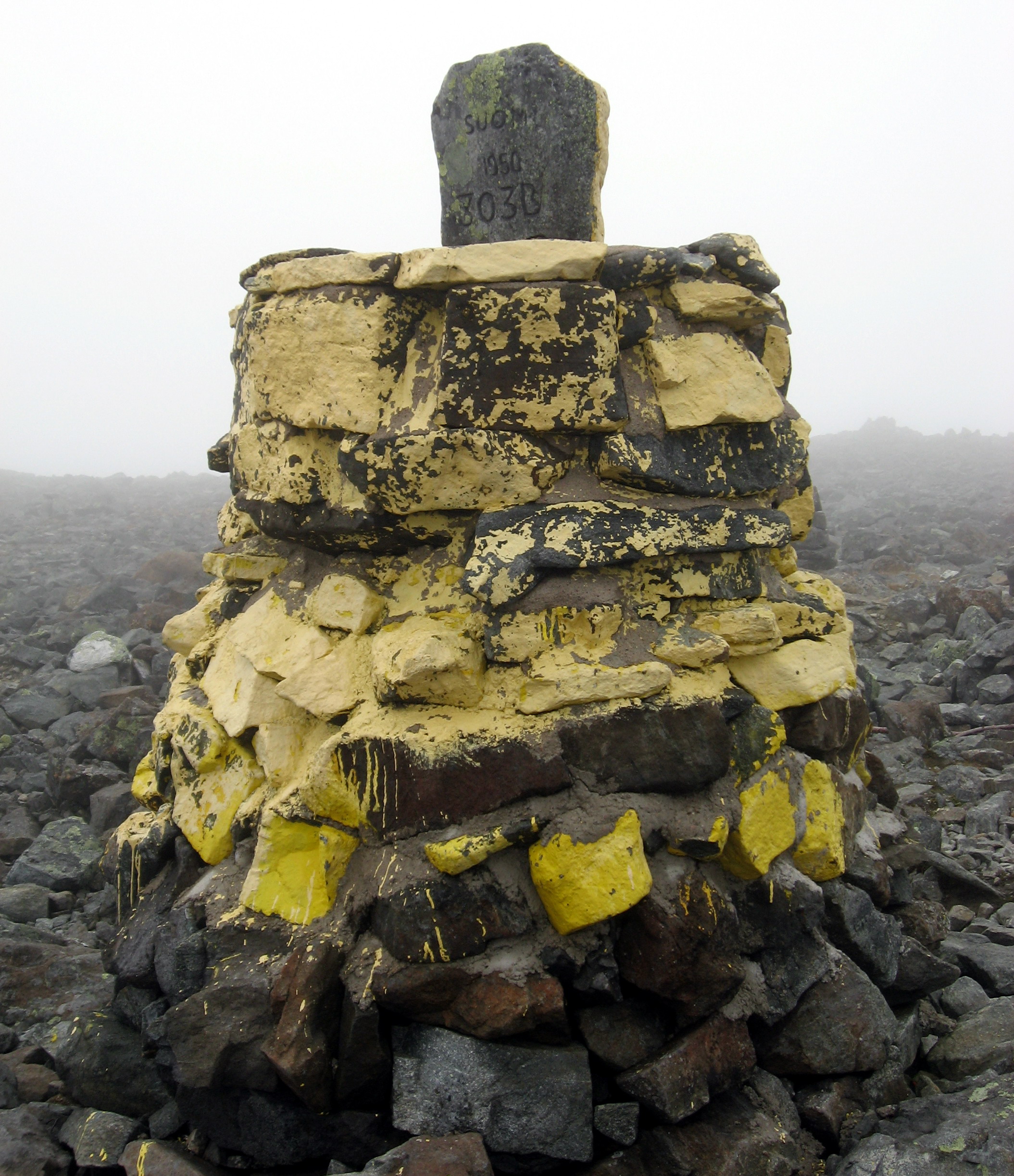 The highest point of Finland, also a border mark | |
| Highest point | |
| Elevation | 1,324 m (4,344 ft) |
| Prominence | 0 m (0 ft) |
| Listing | Highest in Finland |
| Coordinates | 69°18′29″N 21°15′47″E[1] |
| Geography | |
| Location | Norway and Finland |
| Climbing | |
| Easiest route | walk about 50 km (31 mi) from Kilpisjärvi in Finland or walk 6 km (3.7 mi) from Kåfjorddalen in Norway |
The highest point in Finland is on a spur of Ráisduattarháldi at 1,324 m (4,344 ft) known as Hálditšohkka at the border of Norway. The peak proper is not in Finland; the border marker is on a slope.[3] The highest mountain whose peak is in Finland is Ridnitšohkka, at 1,316 m (4,318 ft) and a few kilometers from Halti.
The reason for the border being the way it is can be traced to a Swedish-Danish border treaty in 1734, when Norway belonged to Denmark and Finland was part of Sweden. The treaty specifies the border only by some of its biggest natural features like mountains. Thus, international boundary commissions would walk the border and place border markers where it was convenient. The actual border was then agreed to lie on a straight line between these markers, as was the usual practice at the time.[4]
A 55 km (34 mi) trekking path leads from Saana, Kilpisjärvi to Halti. An easier route goes from a local road (open in summer only) going from Birtavarre in Norway, around 6 km (3+1⁄2 mi) hiking to the highest point in Finland. The route is rocky and not really adapted to hiking.
Proposed border change
In 2015, a group of Norwegians began a campaign to give the peak of Hálditšohkka to Finland for its centenary in 2017 by moving the border between the two countries by 200 m (660 ft).[5] The idea gained substantial public support in both countries, and in July 2016 it was reported that the Prime Minister of Norway, Erna Solberg was seriously considering ceding the peak.[6] Norway ultimately chose not to move the border, citing the Norwegian constitution's definition of the country as an "indivisible and inalienable" realm.[7]
See also
- Scandinavian Mountains
- Extreme points of Finland
- List of highest points of European countries
- Ernst Thälmann Island, gifted symbolically by Cuba to East Germany in 1972.
References
- "Halti, Norway". Peakbagger.com. Retrieved 2018-11-04.
- Store norske leksikon. "Halti" (in Norwegian). Retrieved 2010-04-04.
- "Norja ehdottaa, että Halti saisi uuden huipun Suomen puolella". 9 September 2016.
- "Asiantuntija vastaa: Tämän vuoksi Haltin huippu ei ole Suomen puolella rajaa". 16 December 2015.
- "Norway launches campaign to give Finland a mountain". The Telegraph. 18 December 2015.
- "Norway considers giving mountain to Finland as 100th birthday present". The Guardian. 28 July 2016.
- "Halti plan halted: Norway will not gift mountain top to neighbour Finland". The Guardian. 15 October 2016.
External links
![]() Media related to Halti at Wikimedia Commons
Media related to Halti at Wikimedia Commons
| Authority control |
|
|---|
На других языках
[de] Haltitunturi
Der Haltitunturi (kurz: Halti; auch: Haltiatunturi; nordsamisch Háldi; schwedisch Haldefjäll) ist ein Fjell (tunturi) in Norwegen und Finnland. Mit einer Höhe von 1324 Metern ist er die höchste Erhebung Finnlands.- [en] Halti
[es] Monte Halti
El monte Halti (en finés, Haltitunturi, que significa «tunturi Halti» —un tunturi es una colina poco pronunciada de Fenoscandia—) es el monte más alto de Finlandia, con una altitud de 1324 m s. n. m.. Se encuentra en Laponia, en el municipio de Enontekiö. La cumbre del Halti se encuentra en Noruega y está a 1365 m s. n. m.[fr] Halti
Le Halti (en finnois : Haltitunturi ; en sami : Háldi) est un sommet des Alpes scandinaves s'élevant à 1 361 mètres d'altitude en Norvège. Son versant sud est traversé par la frontière avec la Finlande et constitue le point culminant de ce pays à 1 324 mètres d'altitude[2].[it] Halti
Halti, noto anche con i nomi di Haltitunturi, Haltia o Haltiatunturi (in svedese Haldefjäll, in sami settentrionale Háldi) è la montagna delle Alpi scandinave dove è localizzato il punto più elevato (1.324 m s.l.m.) del territorio della Finlandia.[ru] Халтиа
Халтиа[2], или Халти, или Халтитунтури, или Халтиатунтури (фин. Haltia, Halti, Haltitunturi, Haltiatunturi, сев.‑саам. Háldi, швед. Haldefjäll, норв. Halti) — сопка в западной части финской Лапландии на границе с Норвегией; расположена на территории финской общины Энонтекиё и норвежских коммун Кофьорд и Нуррейса.Другой контент может иметь иную лицензию. Перед использованием материалов сайта WikiSort.org внимательно изучите правила лицензирования конкретных элементов наполнения сайта.
WikiSort.org - проект по пересортировке и дополнению контента Википедии