geo.wikisort.org - Mountains
Ridnitšohkka (Northern Sami: Ritničohkka) is the second-highest point in Finland, though it is the highest mountain with its peak within Finland. The eastern face is steep while the western side is mild. While somewhat popular destination among off-piste skiers, the remoteness (50 km or 31 mi from the nearest settlement) of this mountain makes it very isolated. The mast on the top is for telecommunications, so the emergency services are somewhat available there, which is not true for many other locations in the area.
| Ridnitšohkka | |
|---|---|
| Ritničohkka | |
 Ridnitsohkka as seen from Halti. | |
| Highest point | |
| Elevation | 1,317 m (4,321 ft) |
| Coordinates | 69°17′16″N 021°20′19″E |
| Geography | |
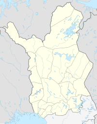 Ridnitšohkka Käsivarsi Wilderness Area, Enontekiö, Lapland, Finland  Ridnitšohkka Ridnitšohkka (Finland) | |
| Parent range | Scandinavian Mountains |
Ridnitšohkka has the most extensive area of permanent snow in Finland. However, during the past years the size of the snowfield has considerably diminished.[1]
References
- Hirvas, Heikki (January 2005). "Geological characteristics of the Halti-Ridnitsohkka region, Enontekio, Finland". Quaternary Studies in the Northern and Arctic Regions of Finland, Kilpisjarvi Biological Station, Finland, Jan. 13-14, 2005 [Quaternary Studies in the Northern and Arctic Regions of Finland. Special Paper.
External links
 Media related to Ridnitšohkka at Wikimedia Commons
This Lapland (Finland) location article is a stub. You can help Wikipedia by expanding it. |
На других языках
[de] Ridnitšohkka
Der Ridnitšohkka ist ein Berg im skandinavischen Gebirge und mit 1.317 Metern der zweithöchste Berg Finnlands und der höchste Berg, dessen Gipfel sich ausschließlich in Finnland befindet. Er liegt auf dem Gebiet der Gemeinde Enontekiö, die als einzige finnische Gemeinde Anteil an dem Gebirge besitzt.- [en] Ridnitšohkka
[fr] Ridnitsohkka
Ridnitsohkka ou Ritničohkka en same du Nord est le plus haut sommet entièrement situé en Finlande à 1 317,1 m d'altitude[1], le mont Halti étant le point culminant du pays mais ayant son sommet en Norvège.[it] Ridnitšohkka
Ridnitšohkka (Ritničohkka in sami settentrionale) è una montagna finlandese situata in Lapponia.Другой контент может иметь иную лицензию. Перед использованием материалов сайта WikiSort.org внимательно изучите правила лицензирования конкретных элементов наполнения сайта.
WikiSort.org - проект по пересортировке и дополнению контента Википедии