geo.wikisort.org - Mountains
Doi Inthanon (Thai: ดอยอินทนนท์, pronounced [dɔ̄ːj ʔīn.tʰā.nōn]) is the highest mountain in Thailand.[1] It is in Chom Thong District, Chiang Mai Province. This mountain is an ultra prominent peak, known in the past as Doi Luang ('big mountain') or Doi Ang Ga, meaning the 'crow's pond top'. Near the mountain's base was a pond where many crows gathered. The name Doi Inthanon was given in honour of Inthawichayanon, last King of Chiang Mai, who was concerned about the forests in the north and tried to preserve them. He ordered that, after his death, his remains be interred at Doi Luang, which was then renamed in his honour.
This article is written like a travel guide rather than an encyclopedic description of the subject. (September 2017) |
| Doi Inthanon | |
|---|---|
 Naphamethinidon and Naphaphonphumisiri, two chedis near the summit of Doi Inthanon. | |
| Highest point | |
| Elevation | 2,565 m (8,415 ft) |
| Prominence | 1,850 m (6,070 ft) |
| Listing | Country high point List of Ultras of Southeast Asia |
| Coordinates | 18°35′15″N 98°29′12″E |
| Geography | |
 Doi Inthanon Thailand | |
| Location | Chiang Mai, Thailand |
| Parent range | Shan Hills |
| Geology | |
| Mountain type | granite batholith |
| Climbing | |
| Easiest route | drive |
Today, the summit of Doi Inthanon is a popular tourist destination for both foreign and Thai tourists, with a peak of 12,000 visitors visiting the summit on New Year's Day. In addition to a range of tourist facilities on the summit, there is also a Royal Thai Air Force weather radar station at the summit and the Thai National Observatory (TNO) at km44.[2]
Geography
Doi Inthanon is the highest peak of the Inthanon Range (Thai: ทิวเขาอินทนนท์) of the Thanon Thong Chai Range, a subrange of the Shan Hills in the Thai highlands stretching southwards from the Daen Lao Range. This range, the southwesternmost of the Shan Highland system, separates the Salween watershed from the Mekong watershed. Other high peaks of the Daen Lao Range are Doi Luang Chiang Dao (2,175 metres (7,136 ft)), Doi Pui (1,685 metres (5,528 ft)), and Doi Suthep (1,601 metres (5,253 ft)).
In 1954, the forests around Doi Inthanon were conserved, creating Doi Inthanon National Park, as one of the original 14 national parks of Thailand.[3] This park now covers 482.4 km² and spreads from the lowlands at 800 metres (2,625 ft) elevation up to the peak at 2,565 metres (8,415 ft). Given the varied climatic and ecological areas regions, the park supports a range of animal species, including over 360 bird species.
On the lower slopes of Doi Inthanon, near the Karen hill tribe village, Ban Sop Had, are the Wachirathan waterfalls (Thai: น้ำตกวชิรธาร), where the Wachirathan (lit. "Diamond Creek") tumbles over a granite escarpment. (18.541790°N 98.599247°E)
Climate
The climate is typically tropical and fairly cool on the summit of Doi Inthanon. In the winter, the average temperature is 6 °C (43 °F) in January and temperatures can sometimes drop below 0 °C (32 °F). On 21 December 2017, an all-time low temperature of −5 °C (23 °F) was recorded at 06:30 at km 44.4.[4] From March to June, temperatures are pleasant, especially at higher altitudes. The rainy season runs from April to November, when it sometimes rains for more than two hours per day.
Geology
Geologically the mountain is a granite batholith in a north-south oriented mountain range. The second-highest peak of this range is Doi Hua Mot Luang at 2,340 metres (7,677 ft).
Environmental issues
In 2014, visitors to the mountain left behind 36 tonnes (35 long tons; 40 short tons) of rubbish.[5]
Places
- On the main road to the summit of Doi Inthanon stand two adjacent chedis, one called Naphamethinidon (นภเมทินีดล), meaning 'by the strength of the land and air', and the other, Naphaphonphumisiri (นภพลภูมิสิริ), meaning 'being the strength of the air and the grace of the land'. These temples were built to honor the 60th birthday anniversary of King Bhumibol Adulyadej in 1987, and the 60th birthday anniversary of Queen Sirikit in 1992, respectively.[6]
- Kio Mae Pan Nature Trail[7]
- The Inthanon Royal Project Research Station: The agricultural station was a King Bhumibol Adulyadej project to help eliminate opium cultivation. It contains a rhododendron garden, and greenhouses for growing ferns, flowering plants, and vegetables.[7]
Gallery
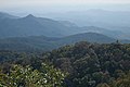 View west from Doi Inthanon
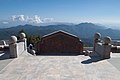 View from the Royal pagoda
 Vegetation on the slopes of Doi Inthanon
 Wachirathan Waterfall
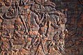 Mural carvings on King’s Pagoda
 Royal Chedi
 View from the top
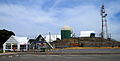 Doi Inthanon control and reporting center on the summit.


See also
- List of mountains in Thailand
- List of Southeast Asian mountains
- List of Ultras of Southeast Asia
- Doi Inthanon rock frog
- List of elevation extremes by country
References
- "Doi Inthanon National Park". Tourism Authority of Thailand (TAT). Archived from the original on 1 May 2015. Retrieved 21 July 2015.
- "Thai National Observatory (TNO)". National Astronomical Research Institute of Thailand (NARIT). Retrieved 4 January 2021.
- "Doi Inthanon National Park". Department of National Parks (DNP) Thailand. Archived from the original on 2007-09-29.
- "Doi Inthanon Observatory sees 'unprecedented' negative 5C temperature". The Nation. 22 December 2017. Retrieved 22 December 2017.
- Sereemongkonpol, Pornchai (15 September 2017). "How to Boost Thai Tourism" (Editorial). Bangkok Post. Retrieved 16 September 2017.
- "Doi Inthanon National Park". Tourism Authority of Thailand (TAT). Archived from the original on 16 September 2017. Retrieved 16 September 2017.
- "Doi Inthanon". Tourism Authority of Thailand (TAT). Archived from the original on 16 September 2017. Retrieved 16 September 2017.
External links
| Wikimedia Commons has media related to Doi Inthanon. |
 Doi Inthanon National Park travel guide from Wikivoyage
- thaibirding.com on Doi Inthanon
- www.DoiInthanon.net
- "Doi Inthanon, Thailand" on Peakbagger
| Authority control |
|
|---|
На других языках
[de] Doi Inthanon
Der Doi Inthanon (Thai .mw-parser-output .Thai{font-size:115%}ดอยอินทนนท์) ist ein Berg in der Provinz Chiang Mai und mit 2565 Metern die höchste Erhebung Thailands.- [en] Doi Inthanon
[fr] Doi Inthanon
Le Doi Inthanon (en thaï : ดอยอินทนนท์) est le plus haut sommet de Thaïlande, avec 2 565 mètres. Il est situé dans la province de Chiang Mai, au nord du pays. L'ancien nom, Doi Luang, signifiant en thaï la « montagne royale », a été changé en Doi Inthanon en l'honneur du prince Intha Witchayanon, le dernier roi de Chiang Mai, dont les cendres ont été transférées en 1897 près de son sommet.[it] Doi Inthanon
Il Doi Inthanon (in thailandese: ดอยอินทนนท์?) è una montagna della Thailandia, con i suoi 2 565 m s.l.m. è la cima più elevata del Paese. Fa parte della catena Doi Inthanon, parte orientale dei monti Thanon Thong Chai, che si sviluppano in catene parallele lungo l'asse nord-sud a partire dall'Altopiano Shan.[1][ru] Дойинтанон
Дойинтанон[источник не указан 983 дня], Дой-Интанон[источник не указан 983 дня], Интханон[1][2], устар. Дой-Ангка[3], Дой-Анка[4], Интанон[5] (тайск. ดอยอินทนนท์) — гора в провинции Чиангмай, высшая точка Таиланда, сложена из гранита и батолита.Другой контент может иметь иную лицензию. Перед использованием материалов сайта WikiSort.org внимательно изучите правила лицензирования конкретных элементов наполнения сайта.
WikiSort.org - проект по пересортировке и дополнению контента Википедии