geo.wikisort.org - Mountains
Ismoil Somoni Peak (Tajik: Қуллаи Исмоили Сомонӣ, Qulla-i Ismō‘il-i Sōmōnî/Qullaji Ismojili Somonī; Persian: قلّهٔ اسماعیل سامانی; Russian: Пик Исмои́ла Сомони́) is the highest mountain in Tajikistan.[1][3][7][8][9][4][5][6] Because it was within the territory of the former Russian Empire and the former Soviet Union, it was the highest mountain in the Russian Empire and Soviet Union before Tajikistan became independent. The mountain is named after Ismail Samani, a ruler of the Samanid dynasty. It is located in the Pamir Range.
| Ismoil Somoni Peak | |
|---|---|
| Stalin Peak, Communism Peak | |
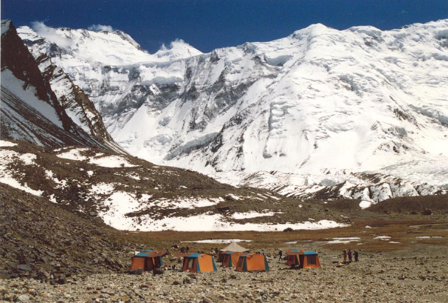 Ismoil Somoni Peak (then known as Communism Peak) taken in 1989. | |
| Highest point | |
| Elevation | 7,495[1][2][3][4][5][6] m (24,590 ft) Ranked 50th |
| Prominence | 3,402 m (11,161 ft) Ranked 54th |
| Isolation | 279 km (173 mi) |
| Listing | Country high point Ultra |
| Coordinates | 38°56′36″N 72°00′58″E |
| Geography | |
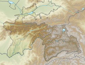 Ismoil Somoni Peak Location in Tajikistan | |
| Location | Northwestern Gorno-Badakhshan, Tajikistan |
| Parent range | Pamirs |
| Climbing | |
| First ascent | 3 September 1933 by Yevgeniy Abalakov and Nikolay Gorbunov. |
| Easiest route | rock/snow/ice climb |

Name
When the existence of a peak in the Soviet Pamir Mountains higher than Lenin Peak was first established in 1928, the mountain was tentatively identified with Garmo Peak.[2] However, as the result of the work of further Soviet expeditions, it became clear by 1932 that they were not the same, and in 1933 the new peak, in the Academy of Sciences Range, was named Stalin Peak[8][9] (Russian: Пик Ста́лина, tr. Pik Stálina), after Joseph Stalin. In 1962, as part of Khrushchev's nationwide de-Stalinization process, the name was changed to Communism Peak (Tajik: Пики Коммунизм, romanized: Piki Komunizm Russian: Пик Коммуни́зма, tr. Pik Kommunízma), a name by which it is still commonly known. The name Communism Peak was officially dropped in 1998 in favour of the current name, commemorating the 9th-10th century Samanid emir, Ismail Samani.[citation needed]
History
The first ascent (to the then Stalin Peak) was made 3 September 1933 by the Soviet mountaineer Yevgeniy Abalakov.[10]
See also
- List of highest mountains on Earth
- Lenin Peak
- Peak Korzhenevskaya
- Mount Garmo
- Patkhor Peak
- List of elevation extremes by country
- Extreme points of Tajikistan
References
- The Free Dictionary: Imeni Ismail Samani Peak
- "Territorial and border issues". Ministry of Foreign Affairs of the Republic of Tajikistan. 1 March 2010. Retrieved 31 January 2020.
The lowest spot of the country is on the height of 300 meters and the highest spot is on the height of 7495 meters above sea level.{...}on the South-East - Pamir (one of the highest spot of the Earth - peak Somoni, with the height of 7495 meters)
- Scheffel, Richard L.; Wernet, Susan J., eds. (1980). Natural Wonders of the World. United States of America: Reader's Digest Association, Inc. pp. 104. ISBN 0-89577-087-3.
- "General information about Tajikistan". Conference on Interaction and Confidence-Building Measures in Asia. Retrieved 31 January 2020.
Tajikistan is a typical mountainous country with absolute heights from 300 to 7495 m. 93% of its territory is occupied by mountains belonging to the highest mountain systems of Central Asia—Tien-Shan and Pamir. Many peaks in Tajikistan are among the highest in the world, rising to a maximum of 7,495m (24,590ft) at Ismoil Somoni Peak (formerly Peak Communism).
- "TAJIKISTAN". The World Factbook. Retrieved 30 January 2020.
highest point: Qullai Ismoili Somoni 7,495 m{...}Geography - landlocked; highest point, Qullai Ismoili Somoni (formerly Communism Peak), was the tallest mountain in the former USSR
- Sally N. Cummings, ed. (2010). Symbolism and Power in Central Asia: Politics of the Spectacular. Routledge. p. 67. ISBN 978-0-415-57567-6 – via Google Books.
IN 1933 THE USSR'S HIGHEST MOUNTAIN, PEAK STALIN ((7,495 m), subsequently renamed Peak Communism and ultimately Ismail Somoni) was climbed as part of a large expedition, the Tajikistan-Pamirs-expedition (TPE).{..}Mount Stalin was the highest point in the USSR
- Martin Hannan (27 October 2011). Harvey Wallbangers and Tam O'Shanters A Book of Eponyms. pp. 45–46. ISBN 9781843588696.
ISMOIL SOMONI PEAK Formerly Stalin Peak and Communism Peak, the highest mountain in the former Soviet Union territories is now called after Ismoil Somoni or Ismail Samani (d. 907), leader of the Samani dynasty which conquered the region now known as the country of Tajikistan in which the mountain rises to a heigh of 7,495m (24,590 ft).
- Stephen K. Batalden, Sandra L. Batalden (1997). The Newly Independent States of Eurasia Handbook of Former Soviet Republics (2 ed.). Oryx Press. ISBN 0-89774-940-5 – via Internet Archive.
Highest elevation
24,590 ft (Kommunizm Peak, in the Pamir Range){{cite book}}: CS1 maint: uses authors parameter (link) - USSR A Reference Book of Facts and Figures. London: Farleigh Press Ltd. 1956. p. 16 – via Internet Archive.
The tallest peaks (in feet above sea-level):
Stalin Peak (Pamirs) 24,583; - V. H. Hillyer and E. G. Huey (1966). The Orient. New York: Meredith Press. p. 102 – via Internet Archive.
The highest peak, Stalin Peak, 24,590 feet, is here.
{{cite book}}: CS1 maint: uses authors parameter (link) - The Great Soviet Encyclopaedia. Communizma Peak. Also Pik Kommunzma at summitpost.org accessed 3Nov2016.
External links
 Media related to Ismail Samani Peak at Wikimedia Commons
- "Pik Kommunizma". SummitPost.org.
- "Ismoil Somoni Peak". Peakware.com. Archived from the original on 2016-03-04.
Authority control | |
|---|---|
| General |
|
| National libraries | |
На других языках
[de] Pik Ismoil Somoni
Pik Ismoil Somoni (tadschikisch Қуллаи Исмоили Сомонӣ/Qullai Ismoili Somonij; russisch Пик имени Исмаила Самани/Pik Imeni Ismaila Samani) ist der höchste Berg in Tadschikistan und der vierthöchste des Pamirs.- [en] Ismoil Somoni Peak
[es] Pico Ismail Samani
El pico Ismail Samani es una montaña de la cordillera de Pamir, localizada en Tayikistán, con una altitud de 7495 metros. Es la mayor cumbre del país centroasiático, y era a su vez la montaña más alta de la antigua Unión Soviética. Es una montaña de dimensiones gigantescas que aparece rodeada por numerosos glaciares. Está localizada en la confluencia de los Montes de la Academia de Ciencias y la cordillera de Pedro Primero.[fr] Pic Ismail Samani
Le pic Ismail Samani (en russe : Pik Imeni Ismaila Samani, en tadjik : Qullai Ismoili Somoni), anciennement pic Staline et pic du Communisme, est le point culminant du Tadjikistan et de l'ancienne Union soviétique. Il s'élève à 7 495 mètres d'altitude dans le massif du Pamir. Gravi pour la première fois en 1933 par Evgeny Abalakov, il est devenu un sommet très fréquenté par les alpinistes.[it] Picco Ismail Samani
Il picco Ismail Samani (in tagico: Қуллаи Исмоили Сомонӣ, Qullai Ismoili Somoni, in russo: Пик Исмоила Сомони) è una montagna del Tagikistan, terza vetta del Pamir dopo il Kungur e il Muztagata. Fino al 1991 in Unione Sovietica, era il più alto rilievo orografico di tale Paese e, perciò, ebbe il nome ufficiale di Picco del Comunismo, denominazione tenuta fino al 1998, sette anni dopo lo scioglimento dell'URSS.[ru] Пик Исмоила Сомони
Пик Исмои́ла Сомони́[2] (тадж. Қуллаи Исмоили Сомонӣ, прежние названия — пик Сталина, пик Коммунизма[3]) (7495 м) — высочайшая вершина Таджикистана, самая высокая точка бывшего Советского Союза[1][4]. Находится на Памире на хребте Академии Наук[5], в месте соединения последнего с хребтом Петра I[1]. В списке высочайших вершин мира находится на 50-м месте.Другой контент может иметь иную лицензию. Перед использованием материалов сайта WikiSort.org внимательно изучите правила лицензирования конкретных элементов наполнения сайта.
WikiSort.org - проект по пересортировке и дополнению контента Википедии