geo.wikisort.org - Mountains
Tai Mo Shan is the highest peak in Hong Kong, with an elevation of 957 metres (3,140 ft).[1] It is located at approximately the geographical centre of the New Territories.
| Tai Mo Shan | |
|---|---|
 Tai Mo Shan, viewed from Tai To Yan in April 2008 | |
| Highest point | |
| Elevation | 957 m (3,140 ft) Hong Kong Principal Datum |
| Coordinates | 22°24′42.52″N 114°7′23.32″E |
| Geography | |
 Tai Mo Shan Location of Tai Mo Shan in Hong Kong | |
| Location | Centre of the New Territories, Hong Kong |
| Tai Mo Shan | |||||||||||||||||
|---|---|---|---|---|---|---|---|---|---|---|---|---|---|---|---|---|---|
| Chinese | 大帽山 | ||||||||||||||||
| Literal meaning | Big Hat Mountain | ||||||||||||||||
| |||||||||||||||||


The Tai Mo Shan Country Park covers an area of 14.40 square kilometres (5.56 sq mi) around Tai Mo Shan.[1] It is located to the north of Tai Lam Country Park. The 35-metre-high (115 ft) Long Falls is the highest waterfall in Hong Kong.[2]
Geography
The whole Tai Mo Shan mountain range, known as Guan Fu Mountain (官富山, named after the salt field Kwun Fu Cheung (官富場) in present-day Kowloon Bay) in Ming and Qing dynasties, covers over 350 square km, and stretches from Tai Lam Chung Reservoir in the West near Tuen Mun and Ma On Shan in the east and the mountains of Kowloon and Clear Water Bay in the south. Two other significant coastal peaks, the Lantau Peak (934m) on Lantau Island and Mount Wutong in Shenzhen (943.7m) are approximately 27 km to the southwest and 21.5 km to the northeast respectively.
Subpeaks
There are a few subpeaks that are given names in the Tai Mo Shan area, including:
- Sze Fong Shan (785 metres (2,575 ft))
- Wo Yang Shan (771 metres (2,530 ft))
- Miu Ko Toi (770 metres (2,526 ft))
- Wo Tong Kong (702 metres (2,303 ft))
- Lin Fa Shan, Tsuen Wan (579 metres (1,900 ft))
- Shek Lung Kung, Tsuen Wan (474 metres (1,555 ft))
- Tin Fu Tsai Shan (461 metres (1,512 ft))
- Ha Fa Shan, Tsuen Wan (315 metres (1,033 ft))
Geology
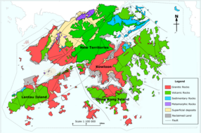
Tai Mo Shan is an inactive volcano dating from the Jurassic period. A small hill known as "Kwun Yam Shan" near the mountain still vents warm air through cracks in the rocks that lead all the way to the mantle. The holes that exhale warm air are known as "hot pots". When the surface temperature is cold, and the warmth of the expelled air is clearly discernible, this phenomenon is referred to by locals as "dragon's breath". If the air temperature at the summit is 6 degrees Celsius, then the air emerging from the interior of Kwun Yum Shan is somewhere between 13 and 21 degrees Celsius. These "hot pots" are remnants of the active volcano's superheated steam vents.[3] The area's volcanic rocks are mainly coarse ash crystal tuff.[4]
Climate
Under the Köppen climate classification, Tai Mo Shan features a humid subtropical climate (Cwa), bordering a subtropical highland climate (Cwb). Due to the height of the mountain, Tai Mo Shan is claimed to be Hong Kong's most misty area, as it is often covered in clouds. In summer it is frequently covered with cumulus clouds, especially on rainy days, and in winter stratus clouds and fog often cover the peak. It is not uncommon for temperatures to drop below freezing point during the winter. A record low of negative 6 Celsius was seen in the January 2016 East Asia cold wave.
| Climate data for Tai Mo Shan (1997–2016) | |||||||||||||
|---|---|---|---|---|---|---|---|---|---|---|---|---|---|
| Month | Jan | Feb | Mar | Apr | May | Jun | Jul | Aug | Sep | Oct | Nov | Dec | Year |
| Record high °C (°F) | 21.5 (70.7) |
23.2 (73.8) |
24.2 (75.6) |
27.4 (81.3) |
28.8 (83.8) |
28.9 (84.0) |
28.8 (83.8) |
29.4 (84.9) |
28.0 (82.4) |
26.6 (79.9) |
25.2 (77.4) |
23.7 (74.7) |
29.4 (84.9) |
| Average high °C (°F) | 13.7 (56.7) |
15.0 (59.0) |
16.9 (62.4) |
19.8 (67.6) |
22.1 (71.8) |
23.5 (74.3) |
24.3 (75.7) |
24.6 (76.3) |
23.6 (74.5) |
21.3 (70.3) |
18.2 (64.8) |
14.7 (58.5) |
19.8 (67.6) |
| Daily mean °C (°F) | 10.4 (50.7) |
11.8 (53.2) |
14.1 (57.4) |
17.4 (63.3) |
20.0 (68.0) |
21.6 (70.9) |
22.2 (72.0) |
22.2 (72.0) |
21.0 (69.8) |
18.5 (65.3) |
15.3 (59.5) |
11.4 (52.5) |
17.2 (63.0) |
| Average low °C (°F) | 7.7 (45.9) |
9.2 (48.6) |
11.7 (53.1) |
15.3 (59.5) |
18.2 (64.8) |
20.0 (68.0) |
20.4 (68.7) |
20.4 (68.7) |
19.3 (66.7) |
16.6 (61.9) |
13.0 (55.4) |
8.8 (47.8) |
15.1 (59.2) |
| Record low °C (°F) | −6.0 (21.2) |
−1.8 (28.8) |
−2.0 (28.4) |
5.6 (42.1) |
9.3 (48.7) |
14.0 (57.2) |
16.8 (62.2) |
18.1 (64.6) |
13.3 (55.9) |
5.7 (42.3) |
−0.3 (31.5) |
−3.3 (26.1) |
−6.0 (21.2) |
| Average precipitation mm (inches) | 43.1 (1.70) |
41.7 (1.64) |
86.4 (3.40) |
161.6 (6.36) |
358.7 (14.12) |
507.7 (19.99) |
406.7 (16.01) |
371.6 (14.63) |
289.0 (11.38) |
99.8 (3.93) |
36.8 (1.45) |
28.2 (1.11) |
2,431.3 (95.72) |
| Average rainy days (≥ 0.5 mm) | 12.0 | 14.5 | 18.3 | 20.9 | 23.0 | 23.4 | 22.9 | 18.9 | 17.2 | 12.5 | 10.4 | 8.5 | 202.5 |
| Average relative humidity (%) | 83 | 89 | 91 | 93 | 95 | 96 | 95 | 93 | 91 | 88 | 84 | 78 | 89 |
| Source: Hong Kong Observatory[5][6][7][8] | |||||||||||||
Vegetation
In the past, Tai Mo Shan was famous for a type of green tea, called mist or cloud tea, which grew wild on the mountain side. Occasionally, local people can still be seen picking the tea shoots for brewing green tea.
More than 1,500 species of plants have been recorded in Tai Mo Shan including 27 species of native wild orchids, the protected Chinese Lily (Lilium brownii) which mostly grows on the east side of the Mountain, 24 species of native ferns, including tree ferns, of which a total of only 4 tree ferns species have been recorded around the entire mountain, 19 species of native grasses, and 7 species of native bamboos. Camellia sinensis var. waldenae (formerly Camellia waldenae) are also found on the mountain.
A few types of wild orchids also grow in the streams of Tai Mo Shan including the Chinese pholidota orchid, Hong Kong's most common orchid, and the bamboo orchid, so called because of a distinct stem that looks like bamboo, which also grows in the streams of Tai Mo Shan.
During the Japanese occupation of Hong Kong in World War II, most of the trees in the park were cut down and extensive reforestation was carried out after the war. Trees that were planted are mostly non-native such as Pinus massoniana, Acacia confusa, Lophostemon confertus, and paper bark tree. The area has now become one of Hong Kong's major forest plantations.
Wildlife
Local wildlife consists of birds, snakes and butterflies.[1] There are also freshwater crabs, feral dogs, feral cats, oxen, Porcupines and wild boar.
History
In 1986, a 34-hour blaze destroyed 282,500 trees at Shing Mun and Tai Mo Shan and ravaged 7.40 km² of countryside.
Tai Mo Shan Country Park was formally designated on the 23rd of February 1979.
Access
The summit of Tai Mo Shan is not accessible to visitors, as it is occupied by a Hong Kong Observatory (ex-RAF) weather radar station. It was reported in July 2014 that the station additionally houses facilities of the People's Liberation Army.[9]
See also
- List of mountains, peaks and hills in Hong Kong
- Country parks and conservation in Hong Kong
- Kadoorie Farm and Botanic Garden
References
- "Tai Mo Shan Country Park". Agriculture, Fisheries and Conservation Department. Retrieved 8 February 2015.
- Kabange, Sanday Chongo (24 July 2012). "The better side of Hong Kong: Top 10 nature reserves". CNN Travel. Retrieved 20 November 2012.
- "8 Mesozoic Post-Volcanic and Tertiary Sedimentary Rocks". CEDD. Retrieved 20 December 2008.
- R.J. Sewell, S.D.G. Campbell, C.J.N. Fletcher, K.W. Lai & P.A. Kirk (2000). The Pre-Quaternary Geology of Hong Kong. Government of Hong Kong SAR. ISBN 962-02-0299-6.
{{cite book}}: CS1 maint: multiple names: authors list (link) - "Monthly Means of Meteorological Elements for Tai Mo Shan, 1997-2016". Hong Kong Observatory. Retrieved 8 February 2017.
- "Monthly Means of Meteorological Elements for Tai Mo Shan, 1997-2016: Cold/Hot Weather and Rainfall statistics". Hong Kong Observatory. Retrieved 8 February 2017.
- "Monthly Maximum Temperature (°C) at Tai Mo Shan, 1997-2016". Hong Kong Observatory. Retrieved 8 February 2017.
- "Monthly Minimum Temperature (°C) at Tai Mo Shan, 1997-2016". Hong Kong Observatory. Retrieved 8 February 2017.
- Cheung, Chi-fai; Wong, Olga (23 July 2014). "Hong Kong 'hands PLA radar station on territory's highest mountain in secret deal'". South China Morning Post. Hong Kong.
External links
| 900 meters or more | |
|---|---|
| 800 to 899 meters | |
| 700 to 799 meters | |
| 600 to 699 meters |
|
| 500 to 599 meters |
|
| 400 to 499 meters (excerpt) |
|
| 300 to 399 meters (excerpt) |
|
| 200 to 299 meters (excerpt) |
|
| 100 to 199 meters (excerpt) |
|
| 99 meters or less (excerpt) |
|
| Collectively |
|
На других языках
[de] Tai Mo Shan
Der Tai Mo Shan (chinesisch 大帽山, Pinyin Dàmào Shān, Jyutping Daai6mou6 Saan1 – „Großer Hut-Berg“) ist mit 957 m[1] die höchste Erhebung in Hongkong. Aufgrund der homophonen Aussprache im Kantonesischen wird der höchste Berg der Sonderverwaltungszone von den einheimischen Bürger Hongkongs umgangssprachlich gern als “Großer Nebelberg” (.mw-parser-output .Hant{font-size:110%}大霧山 / .mw-parser-output .Hans{font-size:110%}大雾山, Dàwù Shān, Jyutping Daai6mou6 Saan1 – „Großer Nebelberg“) bezeichnet.- [en] Tai Mo Shan
[fr] Tai Mo Shan
Tai Mo Shan (chinois : 大帽山 ; cantonais Jyutping : daai6 mou6 saan1, signifiant « montagne du Gros Chapeau » ; aussi chinois : 大霧山 ; cantonais Jyutping : daai6 mou6 saan1, signifiant « montagne Brumeuse ») est le point culminant de Hong Kong, avec une altitude de 957 m. Situé approximativement au centre géographique des Nouveaux Territoires, ce pic montagneux et le territoire l'entourant forment un parc public de 14,40 km2 de superficie dans la partie nord du comté de Tai Lam.[it] Tai Mo Shan
Tai Mo Shan ((ZH) 大帽山) è la montagna più alta di Hong Kong con i suoi 957 metri.[2] È anche il picco più alto della Cina meridionale e la seconda montagna costiera della Cina dopo il Monte Lao, e situata pressoché al centro geografico dei Nuovi Territori.Другой контент может иметь иную лицензию. Перед использованием материалов сайта WikiSort.org внимательно изучите правила лицензирования конкретных элементов наполнения сайта.
WikiSort.org - проект по пересортировке и дополнению контента Википедии