geo.wikisort.org - Mountains
Pok To Yan (Chinese: 薄刀屻, literally "Thin Razor's Edge"), is a mountain on Lantau Island, Hong Kong, with a height of 529 metres (1,736 ft) above sea level.
| Pok To Yan | |
|---|---|
| 薄刀屻 | |
 On the right is Pok To Yan | |
| Highest point | |
| Elevation | 529 m (1,736 ft) |
| Coordinates | 22°16′55″N 113°57′24″E |
| Geography | |
 Pok To Yan Location of Pok To Yan in Hong Kong | |
| Location | Lantau Island, |
Geology
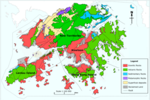
Pok To Yan is formed by Volcanic rocks, much like many of the tallest mountains on Lantau Island, such as Lantau Peak.
Flora
Pok To Yan and neighbouring Por Kai Shan were designated together a "Site of Special Scientific Interest" in 1994. According to the local government, Pok To Yan has "over 200 species of native plants." and "a number of rare and protected indigenous plants".[1]
Geography
To the northwest is Tung Chung, while to the south is Sunset Peak.[2]
See also
- List of mountains, peaks and hills in Hong Kong
References
- "環境保護署 - 策略性環境評估". www.epd.gov.hk. Retrieved 2020-04-10.
- "District Council Constituency Boundaries" (PDF). HK Government Electoral Affairs Commission.
| 900 meters or more | |
|---|---|
| 800 to 899 meters | |
| 700 to 799 meters | |
| 600 to 699 meters |
|
| 500 to 599 meters |
|
| 400 to 499 meters (excerpt) |
|
| 300 to 399 meters (excerpt) |
|
| 200 to 299 meters (excerpt) |
|
| 100 to 199 meters (excerpt) |
|
| 99 meters or less (excerpt) |
|
| Collectively |
|
This article related to a mountain or hill in Hong Kong is a stub. You can help Wikipedia by expanding it. |
Текст в блоке "Читать" взят с сайта "Википедия" и доступен по лицензии Creative Commons Attribution-ShareAlike; в отдельных случаях могут действовать дополнительные условия.
Другой контент может иметь иную лицензию. Перед использованием материалов сайта WikiSort.org внимательно изучите правила лицензирования конкретных элементов наполнения сайта.
Другой контент может иметь иную лицензию. Перед использованием материалов сайта WikiSort.org внимательно изучите правила лицензирования конкретных элементов наполнения сайта.
2019-2026
WikiSort.org - проект по пересортировке и дополнению контента Википедии
WikiSort.org - проект по пересортировке и дополнению контента Википедии