geo.wikisort.org - Mountains
Po Keng Teng (Chinese: 寶鏡頂) is a mountain inside Clear Water Bay Country Park, Sai Kung, New Territories, Hong Kong, with a height of 127 metres (417 ft).[1][2]
| Po Keng Teng | |
|---|---|
| 寶鏡頂 | |
View of Po Keng Teng in Clear Water Bay Peninsula | |
| Highest point | |
| Elevation | 127 m (417 ft) |
| Coordinates | 22°15′59″N 114°18′19″E |
| Geography | |
 Po Keng Teng Location in Hong Kong | |
| Location | |
Geography
Po Keng Teng is in the Clear Water Bay Peninsula region. To the west is a golf club.
The are no public roads that lead to the mountain because a private golf club separates it from the nearest public road. The trails to the summit are rather rocky, and not maintained by the government, so proper hiking footwear is advisable. The cliff on its east side is very steep.
Geology
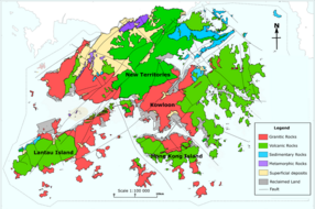
Po Keng Teng is formed by volcanic rocks, like many of the tallest mountains in Hong Kong, such as Tai Mo Shan. Some shorter mountains in Hong Kong are formed by older granitic rocks.
References
- "po keng teng". OpenStreetMap. Retrieved 2021-11-19.
- (PDF) http://www.geodetic.gov.hk/summarysheet/602.1.pdf.
{{cite web}}: Missing or empty|title=(help)
See also
- List of mountains, peaks and hills in Hong Kong
- Clear Water Bay Country Park
| 900 meters or more | |
|---|---|
| 800 to 899 meters | |
| 700 to 799 meters | |
| 600 to 699 meters |
|
| 500 to 599 meters |
|
| 400 to 499 meters (excerpt) |
|
| 300 to 399 meters (excerpt) |
|
| 200 to 299 meters (excerpt) |
|
| 100 to 199 meters (excerpt) |
|
| 99 meters or less (excerpt) |
|
| Collectively |
|
This Hong Kong location article is a stub. You can help Wikipedia by expanding it. |
This article related to a mountain or hill in Hong Kong is a stub. You can help Wikipedia by expanding it. |
Другой контент может иметь иную лицензию. Перед использованием материалов сайта WikiSort.org внимательно изучите правила лицензирования конкретных элементов наполнения сайта.
WikiSort.org - проект по пересортировке и дополнению контента Википедии