geo.wikisort.org - Mountains
Cheung Shan (Chinese: 象山; lit. 'Elephant Mountain'), also known as Middle Hill, is a mountain in Hong Kong at 585 metres (1,919 ft) in height.[1] Located to the north of Kowloon Peak (Fei Ngo Shan) and to the south of Tung Shan, it falls within the Ma On Shan Country Park and straddles the border between Wong Tai Sin and Sai Kung districts.
| Cheung Shan | |
|---|---|
| 象山 | |
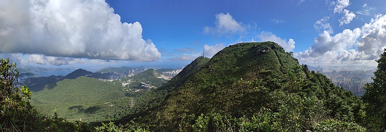
 Cheung Shan is on the far right. Tung Shan is in the middle and a subpeak of Tate's Cairn is on the left. | |
| Highest point | |
| Elevation | 585 m (1,919 ft) |
| Coordinates | 22°21′28.78″N 114°13′5.85″E / 22.3579944°N 114.2182917°E |
| Geography | |
 Cheung Shan Location of Cheung Shan in Hong Kong | |
| Location | |
| Cheung Shan | |||||||||||
|---|---|---|---|---|---|---|---|---|---|---|---|
| Chinese | 象山 | ||||||||||
| Literal meaning | Elephant Mountain | ||||||||||
| |||||||||||
Landscape
 Cheung Shan (Elephant Mountain) viewed from the north. Behind it is Fei Ngo Shan, the highest peak in Kowloon.

See also
- Fei Ngo Shan Road
- List of mountains, peaks and hills in Hong Kong
- Tate's Cairn
References
- 新假期 (2014-10-27). "象山 Middle Hill, Hong Kong@流浪攝 | 生活 | 博客 | Uncategorized". 新假期. Retrieved 2020-03-30.
| 900 meters or more | |
|---|---|
| 800 to 899 meters | |
| 700 to 799 meters | |
| 600 to 699 meters |
|
| 500 to 599 meters |
|
| 400 to 499 meters (excerpt) |
|
| 300 to 399 meters (excerpt) |
|
| 200 to 299 meters (excerpt) |
|
| 100 to 199 meters (excerpt) |
|
| 99 meters or less (excerpt) |
|
| Collectively |
|
This New Territories location article is a stub. You can help Wikipedia by expanding it. |
This New Kowloon location article is a stub. You can help Wikipedia by expanding it. |
На других языках
- [en] Cheung Shan (Kowloon)
[fr] Jeung Shan
Jeung Shan (chinois : 象山 ; cantonais Jyutping : zoeng6 saan1), ou Middle Hill[1], est un sommet de Hong Kong situé à l'est de New Kowloon et culminant à une altitude de 585 mètres, appartenant à la même chaîne de collines que celle du pic Kowloon.Текст в блоке "Читать" взят с сайта "Википедия" и доступен по лицензии Creative Commons Attribution-ShareAlike; в отдельных случаях могут действовать дополнительные условия.
Другой контент может иметь иную лицензию. Перед использованием материалов сайта WikiSort.org внимательно изучите правила лицензирования конкретных элементов наполнения сайта.
Другой контент может иметь иную лицензию. Перед использованием материалов сайта WikiSort.org внимательно изучите правила лицензирования конкретных элементов наполнения сайта.
2019-2026
WikiSort.org - проект по пересортировке и дополнению контента Википедии
WikiSort.org - проект по пересортировке и дополнению контента Википедии