geo.wikisort.org - Mountains
Lantau Peak or Fung Wong Shan (literally "Phoenix Mountain") is the second highest peak in Hong Kong and the highest point on Lantau Island, with a height of 934 metres (3,064 ft) above sea level.[1]
| Lantau Peak | |
|---|---|
| 鳳凰山 | |
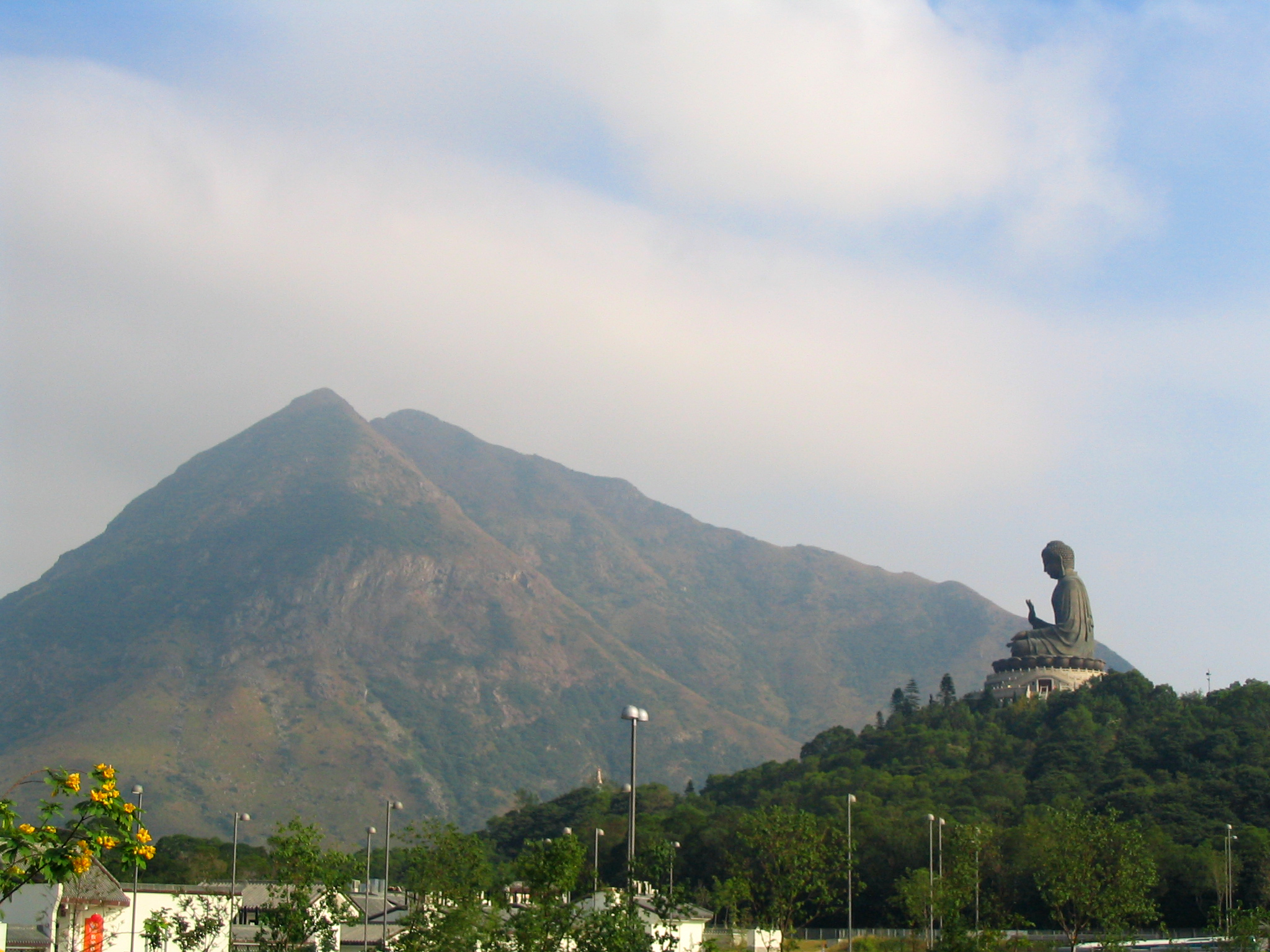 Lantau Peak rises high above the Tian Tan Buddha. | |
| Highest point | |
| Elevation | 934 m (3,064 ft) |
| Prominence | 934 m (3,064 ft) |
| Coordinates | 22°14′59.17″N 113°55′16.69″E |
| Geography | |
 Lantau Peak Location of Lantau Peak in Hong Kong | |
| Location | Lantau Island, |
| Lantau Peak | |||||||||||||
|---|---|---|---|---|---|---|---|---|---|---|---|---|---|
| Traditional Chinese | 鳳凰山 | ||||||||||||
| Simplified Chinese | 凤凰山 | ||||||||||||
| |||||||||||||
Name origin
The mountain is actually made up of a pair of peaks, one is known as "Fung Shan" (male phoenix mountain) and the other is "Wong Shan" (female phoenix mountain), together they form "Fung Wong Shan".
Location
Lantau Peak is located near the center of Lantau Island, west of Sunset Peak, and within Lantau South Country Park. It is reachable by the Lantau Trail. At the foot of Lantau Peak, a tourist spot called the Wisdom Path (心經簡林) can be found.[2]
Geology
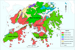
Lantau Peak is formed by Volcanic rocks, including porphyritic rhyolites,[3] like many of the tallest mountains in Hong Kong, such as Tai Mo Shan. Some shorter mountains in Hong Kong are formed by older Granitic rocks.
Lantau Peak is also the source of water for Tung Chung River, a major river on Lantau Island.[4]
Climate
Lantau Peak is located in central Lantau Island, with an elevation of 934 meters above sea level (23 metres shorter than Tai Mo Shan, Hong Kong's highest peak).[1] Under the Köppen climate classification, Lantau Peak features a subtropical highland climate. Due to its elevation, strong winds and fog occur throughout the year. Winter is cold with temperatures often dipping below 0 °C; summer is warm with temperatures reaching tops of 18-22 °C; spring is cool and humid; autumn is cool and dry. Because there is no weather station at the top of Lantau Peak (934m), the Ngong Ping Weather Station of the Hong Kong Observatory (593m)[5] can be used as reference for the temperature at the summit.
| Climate data for Lantau Peak | |||||||||||||
|---|---|---|---|---|---|---|---|---|---|---|---|---|---|
| Month | Jan | Feb | Mar | Apr | May | Jun | Jul | Aug | Sep | Oct | Nov | Dec | Year |
| Average high °C (°F) | 8.3 (46.9) |
10.2 (50.4) |
11.9 (53.4) |
14.2 (57.6) |
16.6 (61.9) |
17.8 (64.0) |
18.5 (65.3) |
19.2 (66.6) |
18.7 (65.7) |
16.6 (61.9) |
13.5 (56.3) |
10.0 (50.0) |
14.6 (58.3) |
| Daily mean °C (°F) | 4.9 (40.8) |
7.2 (45.0) |
9.0 (48.2) |
13.1 (55.6) |
14.8 (58.6) |
16.3 (61.3) |
16.9 (62.4) |
17.1 (62.8) |
16.3 (61.3) |
13.8 (56.8) |
10.6 (51.1) |
6.8 (44.2) |
12.2 (54.0) |
| Average low °C (°F) | 2.3 (36.1) |
4.9 (40.8) |
6.8 (44.2) |
10.0 (50.0) |
13.1 (55.6) |
14.7 (58.5) |
15.3 (59.5) |
15.3 (59.5) |
14.5 (58.1) |
11.9 (53.4) |
8.4 (47.1) |
4.2 (39.6) |
10.1 (50.2) |
| Source: Climate Data for Lantau Peak — Hong Kong Observatory | |||||||||||||

See also
- List of mountains, peaks and hills in Hong Kong
- Sunset Peak
- Yi Tung Shan
References
- "Lantau South". www.afcd.gov.hk. Retrieved 18 September 2019.
- "Tourism Commission - Completed". www.tourism.gov.hk. Retrieved 18 September 2019.
- "Lantau Volcanic Group (undifferentiated) - Jlu". www.cedd.gov.hk. Retrieved 26 April 2020.
- "JC WISE - Rivers@HK Database | Faculty of Social Sciences, HKU". www.jcwise.hk. Retrieved 15 April 2021.
- "Variation of Wind Direction and Speed". www.hko.gov.hk. Retrieved 18 September 2019.
| 900 meters or more | |
|---|---|
| 800 to 899 meters | |
| 700 to 799 meters | |
| 600 to 699 meters |
|
| 500 to 599 meters |
|
| 400 to 499 meters (excerpt) |
|
| 300 to 399 meters (excerpt) |
|
| 200 to 299 meters (excerpt) |
|
| 100 to 199 meters (excerpt) |
|
| 99 meters or less (excerpt) |
|
| Collectively |
|
| Authority control: National libraries |
|---|
This Hong Kong location article is a stub. You can help Wikipedia by expanding it. |
На других языках
[de] Lantau Peak
Der Lantau Peak, auf Chinesisch amtlich Fung Wong Shan genannt, ist mit 934 m Höhe die höchste natürliche Erhebung auf der Insel Lantau und die zweithöchste Erhebung Hongkongs – höchste Erhebung Taimoshan 957 m. Der Launtau Peak gehört laut „Verein der Country Park-Freunden“ zu den zehn beliebtesten Ausflugsziele in Hongkong.[2] Der 2005 eröffneter Wanderpfad Wisdom Path – 心經簡林[3] – (deutsch Weisheitspfad – früher Heart Sutra Inscription – „Herz-Sutra-Inschrift“, ⊙22.255113.91388888889) befindet sich im beliebten Lantau North Country Park der Insel.[4][5][6]- [en] Lantau Peak
[fr] Pic de Lantau
Le pic de Lantau (anglais : Lantau Peak), également appelé Fung Wong Shan (chinois simplifié : 凤凰山 ; chinois traditionnel : 鳳凰山 ; pinyin : Fènghuáng Shān, littéralement « montagne du Phœnix »), est le deuxième plus haut sommet de Hong Kong et le point culminant de l'île de Lantau, avec une altitude de 934 mètres. Le pic est un des lieux de randonnée les plus populaires de Hong Kong et peut être atteint par le Lantau Trail[1].Другой контент может иметь иную лицензию. Перед использованием материалов сайта WikiSort.org внимательно изучите правила лицензирования конкретных элементов наполнения сайта.
WikiSort.org - проект по пересортировке и дополнению контента Википедии