geo.wikisort.org - Island
Waglan Island is a member of the Po Toi group of islands in Hong Kong. It hosts a ground of meteorological observation and recording.
橫瀾島 | |
|---|---|
 Waglan Island and the Po Toi group of islands | |
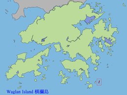 Location of Waglan Island within Hong Kong | |
| Geography | |
| Location | South China Sea |
| Area | 0.104 km2 (0.040 sq mi) |
| Administration | |
| District | Islands District |
| Demographics | |
| Population | 0 |
| Waglan Island | |||||||||||||
|---|---|---|---|---|---|---|---|---|---|---|---|---|---|
| Traditional Chinese | 橫瀾島 | ||||||||||||
| Simplified Chinese | 横澜岛 | ||||||||||||
| |||||||||||||

Waglan lighthouse
 Aerial view of Waglan Island | |
 | |
| Location | Waglan Island, Hong Kong |
|---|---|
| Coordinates | 22.181991°N 114.302880°E |
| Tower | |
| Constructed | 1893 |
| Construction | cast iron tower |
| Automated | 1989 |
| Height | 16 metres (52 ft) |
| Shape | cylindrical tower with balcony and lantern |
| Markings | white tower with a horizontal red band under the balcony, white lantern |
| Heritage | declared monuments of Hong Kong |
| Fog signal | two blasts every 60s. |
| Light | |
| Focal height | 69 metres (226 ft) |
| Range | 24 nautical miles (44 km; 28 mi) |
| Characteristic | Fl (2) W 20s. |
| Hong Kong no. | HK-102[1] |
The Waglan Lighthouse on Waglan Island has been listed as a declared monument of Hong Kong since 2000. It commenced operation in 1893; it is one of the five surviving pre-war lighthouses in Hong Kong.[2]
Climate
| Climate data for Waglan Island (1989-2016) | |||||||||||||
|---|---|---|---|---|---|---|---|---|---|---|---|---|---|
| Month | Jan | Feb | Mar | Apr | May | Jun | Jul | Aug | Sep | Oct | Nov | Dec | Year |
| Record high °C (°F) | 28.5 (83.3) |
28.8 (83.8) |
32.3 (90.1) |
33.4 (92.1) |
37.9 (100.2) |
38.4 (101.1) |
37.7 (99.9) |
38.1 (100.6) |
36.9 (98.4) |
35.1 (95.2) |
33.1 (91.6) |
29.9 (85.8) |
38.4 (101.1) |
| Average high °C (°F) | 18.3 (64.9) |
18.6 (65.5) |
20.7 (69.3) |
24.7 (76.5) |
28.3 (82.9) |
30.4 (86.7) |
31.3 (88.3) |
31.3 (88.3) |
30.6 (87.1) |
28.2 (82.8) |
24.5 (76.1) |
20.3 (68.5) |
25.6 (78.1) |
| Daily mean °C (°F) | 15.5 (59.9) |
15.9 (60.6) |
18.0 (64.4) |
21.8 (71.2) |
25.3 (77.5) |
27.5 (81.5) |
28.2 (82.8) |
28.0 (82.4) |
27.3 (81.1) |
25.1 (77.2) |
21.5 (70.7) |
17.6 (63.7) |
22.7 (72.9) |
| Average low °C (°F) | 13.2 (55.8) |
14.3 (57.7) |
16.3 (61.3) |
20.1 (68.2) |
23.5 (74.3) |
25.7 (78.3) |
26.0 (78.8) |
25.8 (78.4) |
24.6 (76.3) |
23.4 (74.1) |
19.7 (67.5) |
15.7 (60.3) |
20.0 (68.0) |
| Record low °C (°F) | 3.4 (38.1) |
6.0 (42.8) |
7.8 (46.0) |
10.2 (50.4) |
17.4 (63.3) |
20.2 (68.4) |
21.5 (70.7) |
21.7 (71.1) |
18.7 (65.7) |
16.1 (61.0) |
9.8 (49.6) |
4.4 (39.9) |
3.4 (38.1) |
| Source: Hong Kong Observatory[3] | |||||||||||||
See also
- Hong Kong Observatory
- Green Island Lighthouse Compound
- Cape D'Aguilar Lighthouse
- Tang Lung Chau Lighthouse
- List of lighthouses in China
- SS Hsin Wah
References
- Rowlett, Russ. "Lighthouses of China: Hong Kong". The Lighthouse Directory. University of North Carolina at Chapel Hill. Retrieved 13 January 2016.
- Antiquities and Monuments Office:Waglan Lighthouse
- "Extract of Annual Data - Waglan Islandy, 1989-2016". Hong Kong Observatory. Retrieved 27 February 2017.
Further reading
- Ha, Louis; Waters, Dan (2001). "Hong Kong's Lighthouses and the Men Who Manned Them" (PDF). Royal Asiatic Society Hong Kong Branch. 41: 281–320. ISSN 1991-7295.
External links
- Hong Kong Observatory website
- Aerial image from Google Maps
- Map of Waglan Island
- Mr. Deacon, "About Waglan Lighthouse
Wikimedia Commons has media related to Waglan Island.
Authority control | |||
|---|---|---|---|
| General |
| ||
| National libraries | |||
| Additional |
| ||
This Hong Kong location article is a stub. You can help Wikipedia by expanding it. |
На других языках
- [en] Waglan Island
[es] Isla Waglan
La isla Waglan (en chino, 横 澜 岛; cantonés: Wang Lan To) es una isla miembro del grupo de las islas Po Toi en la Región administrativa especial de Hong Kong parte de China. Alberga un campo de observación meteorológica.Текст в блоке "Читать" взят с сайта "Википедия" и доступен по лицензии Creative Commons Attribution-ShareAlike; в отдельных случаях могут действовать дополнительные условия.
Другой контент может иметь иную лицензию. Перед использованием материалов сайта WikiSort.org внимательно изучите правила лицензирования конкретных элементов наполнения сайта.
Другой контент может иметь иную лицензию. Перед использованием материалов сайта WikiSort.org внимательно изучите правила лицензирования конкретных элементов наполнения сайта.
2019-2026
WikiSort.org - проект по пересортировке и дополнению контента Википедии
WikiSort.org - проект по пересортировке и дополнению контента Википедии