geo.wikisort.org - Mountains
The Thanon Thong Chai Range (Thai: ทิวเขาถนนธงชัย, pronounced [tʰīw kʰǎw tʰānǒn tʰōŋ t͡ɕʰāj], formerly Thanon Range; Burmese Tanen Taunggyi)[1] is a mountain range in northern Thailand. Its tallest peak is Doi Inthanon, the highest point in Thailand. Most of the range is in Chiang Mai Province, with parts in Mae Hong Son and Lamphun Provinces.
| Thanon Thong Chai Range Thanon Range / Tanen Taunggyi | |
|---|---|
| เทือกเขาถนนธงชัย | |
 The east side of the eastern Thanon Thong Chai Range rising above Chiang Mai airport | |
| Highest point | |
| Peak | Doi Inthanon |
| Elevation | 2,565 m (8,415 ft) |
| Coordinates | 18°35′16″N 98°29′13″E |
| Dimensions | |
| Length | 170 km (110 mi) N/S |
| Width | 80 km (50 mi) E/W |
| Geography | |
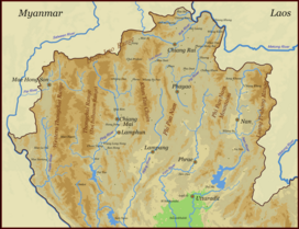 Map of the Thai highlands
| |
| Country | Thailand |
| Provinces | Chiang Mai, Mae Hong Son and Lamphun |
| Parent range | Shan Hills |
| Geology | |
| Age of rock | Precambrian |
| Type of rock | Granite and limestone |


Geologically in the Thanon Thong Chai Range, as in the other southern subranges of the Shan Hills, layers of alluvium are superimposed on hard rock. Precambrian rocks are present in this range, but absent in the ranges further east, such as the Khun Tan Range.[2]
Geography
The Thanon Thong Chai Range is the southernmost prolongation of the Shan Hills and it consists of two parallel ranges running southwards from the southwestern limits of the Daen Lao Range between rivers Yuam and Ping. The eastern range is also known as Inthanon Range (ทิวเขาอินทนนท์). Often the Dawna Range further west and south is included as the western part of the Thanon Thong Chai Range. There are also some geographers who include the Thanon Thong Chai as a subrange of the Daen Lao Range.[3]
Doi Inthanon, at 2,565 metres (8,415 ft) in the Inthanon Range, is one of the ultra prominent peaks of Southeast Asia.[4] Other high peaks of the Thanon Thong Chai Range are 2,340 metres (7,680 ft) high Doi Hua Mot Luang, the second highest peak in Thailand, Doi Pui (1,685 metres (5,528 ft)), and 1,676 metres (5,499 ft) high Doi Suthep.[5]
History
Certain hill tribe communities live in the range, like the Hmong and the Karen whose tribal villages dot the mountainsides.[6] Some of these communities are regularly visited by organized tourist groups.[7]
Doi Inthanon was formerly known as Doi Ang Ka and was renamed in honor of King Inthawichayanon at the end of the 19th century.
Ecology
The vegetation is mostly deciduous forest below 1,000 metres (3,300 ft) and evergreen hill forest above this height but there has been heavy deforestation. Since a great proportion of the original forest cover has disappeared, denuded patches of grassland and mixed bushy vegetation are common. Some projects for the restoration of forest cover have been undertaken in ecologically degraded areas.[8]
Animal species in the Thanon Thong Chai Range are threatened by deliberate wildfires that are set seasonally by farmers in different areas across the range. Wild fauna in the range includes Sambar deer, barking deer, serow, leopard, goral and the Tenasserim white-bellied rat, as well as many bird species.[9] A number of national parks and wildlife sanctuaries are found in the range.
Protected areas
- Doi Inthanon National Park
- Doi Suthep-Pui National Park
- Khun Khan National Park
- Mae Ngao National Park
- Mae Ping National Park
- Mae Tho National Park
- Mae Wang National Park
- Namtok Mae Surin National Park
- Op Luang National Park
- Op Khan National Park
- Chiang Dao Wildlife Sanctuary
- Lum Nam Pai Wildlife Sanctuary[10]
- Mae Lao-Mae Sae Wildlife Sanctuary[11]
- Mae Tuen Wildlife Sanctuary
- Om Koi Wildlife Sanctuary[12]
See also
- Deforestation in Thailand
- Doi Inthanon
- Western Forest Complex
- Thai highlands
References
- North of Thailand Archived 2012-01-28 at the Wayback Machine
- "Geology of Thailand". Department of Mineral Resources. Archived from the original on 1 December 2017. Retrieved 1 June 2019.
- The Physical Geography of Southeast Asia, Avijit Gupta, Oxford University Press, 2005. ISBN 978-0-19-924802-5
- "Doi Inthanon, Thailand". Peakbagger. Retrieved 1 June 2019.
- Wolf Donner, The Five Faces of Thailand. Institute of Asian Affairs, Hamburg 1978 - ISBN 0-7022-1665-8
- "The Politics of Ethnic Tourism in Northern Thailand" (PDF). Archived from the original (PDF) on 2012-05-16. Retrieved 2012-01-08.
- Doi Inthanon, Waterfall & Meo Hilltribe Archived 2012-01-02 at the Wayback Machine[dead link]
- FAO - Restoration of degraded forest land in Thailand: the case of Khao Kho
- Goral and Serow – Rare goat-antelopes
- Lum Nam Pai Wildlife Sanctuary[permanent dead link]
- "Mae Lao-Mae Sae Wildlife Sanctuary and Doi Sam Muen". Archived from the original on 2015-05-02. Retrieved 2012-02-19.
- Om Koi Wildlife Sanctuary[permanent dead link]
External links
- Google Books, The Physical Geography of Southeast Asia
- Doi Inthanon - Climbing Thailand's Highest Mountain
- Peakbagger - Shan-Western Thailand
- Doi Mae Ta Man
На других языках
- [en] Thanon Thong Chai Range
[es] Cordillera Thanon Thong Chai
La cordillera Thanon Thong Chai ( en tailandés, ทิวเขาถนนธงชัย, anteriormente cordillera Thanon; Birmano, Tanen Taunggyi ) es una cadena montañosa en el norte de Tailandia. Su pico más alto es el Doi Inthanon, el punto más alto de Tailandia. La mayor parte de la cadena se encuentra en la provincia de Chiang Mai, con partes en las provincias de Mae Hong Son y Lamphun.[it] Thanon Thong Chai
La catena montuosa Thanon Thong Chai (in thailandese: ทิวเขาถนนธงชัย?, traslitterato: Thiw Khao Thanon Thong Chai) è la più estesa della Thailandia, è suddivisa in tre rami che si sviluppano lungo l'asse nord-sud e si trova nel nord-est del Paese. È considerata l'estensione verso sud delle catene che formano l'Altopiano Shan, in particolare dei monti Daen Lao.[2] Come altre catene della parte sud dell'altopiano Shan, si è formata con strati di sedimenti alluvionali depositati su pietra dura.[1] La cima più elevata è il Doi Inthanon, che con i suoi 2 565 metri è anche la più alta montagna thailandese.[3][ru] Танентаунджи
Танента́унджи — горный хребет на западе Таиланда и частично в Мьянме.Другой контент может иметь иную лицензию. Перед использованием материалов сайта WikiSort.org внимательно изучите правила лицензирования конкретных элементов наполнения сайта.
WikiSort.org - проект по пересортировке и дополнению контента Википедии