geo.wikisort.org - Mountains
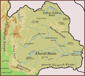
The Phu Phan mountains (Thai: ทิวเขาภูพาน, RTGS: Thio Khao Phu Phan, pronounced [tʰīw kʰǎw pʰūː pʰāːn]) are a range of hills dividing the Khorat Plateau of the Isan region of Thailand into two basins: the northern Sakhon Nakhon Basin, and the southern Khorat Basin.[1]
| Phu Phan Mountains | |
|---|---|
| ทิวเขาภูพาน | |
 Phu Phan Mountains, view from Wat Tham Kham | |
| Highest point | |
| Peak | Phu Lang Ka |
| Elevation | 624 m (2,047 ft) |
| Coordinates | 16°46′22″N 104°21′45″E |
| Dimensions | |
| Length | 180 km (110 mi) NW/SE |
| Width | 50 km (31 mi) NE/SW |
| Geography | |
 Map of Isan showing the Phu Phan Range
| |
| Country | Thailand |
| Region | Nong Bua Lamphu Udon Thani Sakon Nakhon Nakhon Phanom Kalasin Roi Et Maha Sarakham Mukdahan |
| Geology | |
| Age of rock | Early Cretaceous |
| Type of rock | Sandstone and siltstone |
The silhouette of the Phu Phan Mountains appears in the provincial seal of Kalasin since they form the northern boundary of the province.[2]
The Phu Phan mountains are among the places in Thailand more severely affected by the Illegal logging of Phayung (Siamese Rosewood) trees. Although officially a protected tree, the cutting and trading of the endangered rosewood trees has been going unabated in Thailand's mountainous forested zones, even in the protected areas. In Thailand and in China this wood is highly valued in the furniture industry.[3][4]
Etymology
The name of the range is derived from the characteristic tabletop shape of its peaks, for phan is a kind of traditional tray on a pedestal.
Phu is the word for mountain in the Isan/Lao language (as opposed to khao in central and southern Thai and doi in northern Thai).
Geography
The Phu Phan Mountains rise above the plateau and are not prominent. They straddle most of the provinces of northern and eastern Isan, including Khon Kaen, Nong Bua Lamphu, Udon Thani, Sakon Nakhon, Nakhon Phanom, Kalasin, Roi Et, Maha Sarakham, and Mukdahan Province.
The highest elevation of the Phu Phan Range is the 641 m high summit known as Phu Lang Ka. It is in Nakhon Phanom Province.[5] Other important peaks are 624 m high Phu Mai Hia in Mukdahan Province[6] and the 563 m high summit known as Phu Langka Nuea in Nakhon Phanom Province.
The hills are mostly deforested, although patches covered with mixed deciduous forest remain in zones spread across the range.[7]
Phu Phan Royal Palace is in the area, as is the Nam Un dam.[8] Other local sights are Lake Nong Han near Sakon Nakhon and the Khmer-style chedi ruins of Phu Phek, dating from 1050.
Protected areas
The area of the Phu Phan mountains includes national parks and other protected areas:[9][10]
- Phu Phan National Park
- Phu Wiang National Park
- Than Ngam Forest Park
- Kosam Phi Forest Park
- Nam Phong National Park
- Phu Faek Forest Park
- Phu Kao–Phu Phan Kham National Park
- Phu Pha Lek National Park
- Huai Huat National Park (Phu Pha Yon)
- Phu Phra Bat Buabok Forest Park
See also
- Khok Kruat Formation
References
- Schuler, Ulrich. "NE-Thailand (Isan)". Geosciences. Retrieved 23 July 2017.
- Seals of The Provinces of Thailand
- Fredrickson, Terry (2011-09-19). "Forest robbery". Bangkok Post. Retrieved 10 November 2015.
- Waewkraihong, Jakkrit (6 Feb 2013). "Cambodians caught for phayung smuggling". Bangkok Post. Retrieved 10 November 2015.
- "PHU LANGKA NATIONAL PARK". Tourism Authority of Thailand (TAT). Retrieved 23 July 2017.
- "Phu Mai Hia". getamap.net. Retrieved 23 July 2017.
- Phu Kao - Phu Phan Kham National Park Archived 2012-04-26 at the Wayback Machine
- Nam Un Dam Archived 2012-04-26 at the Wayback Machine
- National Parks Archived 2008-12-04 at the Wayback Machine
- "Phu Phan National Park". Trek Thailand. Retrieved 23 July 2017.
External links
| Wikimedia Commons has media related to Phu Phan Mountains. |
На других языках
[de] Phu-Phan-Höhenzug
Der Phu Phan-Höhenzug (Thai .mw-parser-output .Thai{font-size:115%}เทือกเขาภูพาน, [.mw-parser-output .IPA a{text-decoration:none}tʰʉ̂ak-kʰǎo pʰuː-pʰaːn], engl.: Phu Phan Range) ist ein Mittelgebirge, das die Khorat-Hochebene im Isaan (Nordost-Thailand) in zwei Becken teilt: das nördliche Sakhon Nakhon-Becken und das südliche Khorat-Becken.- [en] Phu Phan Mountains
[es] Montañas de Phu Phan
Las Montañas de Phu Phan (en tailandés: เทือกเขา ภู พาน) son una serie de montañas en la región de Isan de Tailandia, que dividen la meseta de Khorat en dos cuencas hidrográficas: la del norte, Sakon Nakhon, y la del sur, Khorat. Las montañas se distribuyen por las provincias de Nongbua Lamphu, Khon Kaen, Udon Thani, Sakon Nakhon, Nakhon Phanom, Kalasin y Mukdahan.[it] Monti Phu Phan
I monti Phu Phan (in thailandese: ทิวเขาภูพาน?, RTGS: Thio Khao Phu Phan, pronuncia IPA: tʰīw kʰǎw pʰūː pʰāːn) sono una catena montuosa situata sull'altopiano di Korat, nella regione dell'Isan della Thailandia.Другой контент может иметь иную лицензию. Перед использованием материалов сайта WikiSort.org внимательно изучите правила лицензирования конкретных элементов наполнения сайта.
WikiSort.org - проект по пересортировке и дополнению контента Википедии