 Looking out over Burma from Thailand, into the heart of the range
![Wat Phra That Doi Wao [th] and the Daen Lao Range, Thai highlands](//upload.wikimedia.org/wikipedia/commons/thumb/0/01/Wat_Phra_Dhatu_Doi_Wao_%E0%B8%A7%E0%B8%B1%E0%B8%94%E0%B8%9E%E0%B8%A3%E0%B8%B0%E0%B8%98%E0%B8%B2%E0%B8%95%E0%B8%B8%E0%B8%94%E0%B8%AD%E0%B8%A2%E0%B9%80%E0%B8%A7%E0%B8%B2_%28October_2021%29_-_img_07.jpg/195px-Wat_Phra_Dhatu_Doi_Wao_%E0%B8%A7%E0%B8%B1%E0%B8%94%E0%B8%9E%E0%B8%A3%E0%B8%B0%E0%B8%98%E0%B8%B2%E0%B8%95%E0%B8%B8%E0%B8%94%E0%B8%AD%E0%B8%A2%E0%B9%80%E0%B8%A7%E0%B8%B2_%28October_2021%29_-_img_07.jpg) Wat Phra That Doi Wao and the Daen Lao Range, Thai highlands
Wat Phra That Doi Wao and the Daen Lao Range, Thai highlands The eastern end of the town of Santikhiri at Doi Mae Salong
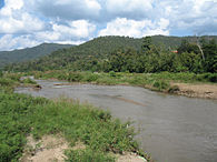 The range above the Pai River in Pai District. This river has its source in the SW of the range
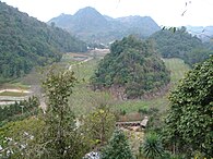 Ang Khang Royal Agricultural Station
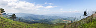
 View from Rte 1340 in Chai Prakan District
geo.wikisort.org - Mountains
The Daen Lao Range (Thai: ทิวเขาแดนลาว,[1] pronounced [tʰīw kʰǎw dɛ̄ːn lāːw]; Burmese: Loi La) is a mountain range of the Shan Hills in eastern Burma and northern Thailand. Most of the range is in Shan State, with its northern limit close to the border with China, and runs southwards across the Thai border, at the northern end of Thailand.
| Daen Lao Range | |
|---|---|
| ทิวเขาแดนลาว / Loi La | |
 Doi Nang Non, the "Mountain of the Sleeping Lady" | |
| Highest point | |
| Peak | Loi Pangnao |
| Elevation | 2,563 m (8,409 ft) |
| Coordinates | 28°18′N 100°20′E |
| Dimensions | |
| Length | 355 km (221 mi) NE/SW |
| Width | 50 km (31 mi) NW/SE |
| Geography | |
 Location of the Daen Lao Range
| |
| Countries | Burma and Thailand |
| Parent range | Shan Hills |
| Geology | |
| Type of rock | granite and limestone |

Geologically in the Daen Lao Range, as in the other southern subranges of the Shan Hills, layers of alluvium are superimposed on hard rock.[2]
Geography
The range extends east of the Salween until almost reaching the Golden Triangle area, separating the Salween watershed from the Mekong watershed. At its southern end the Thanon Thong Chai Range (เทือกเขาถนนธงชัย) subrange stretches further southwards into Thailand between the Sai River in the east and the Pai River in the west; the latter separating the Daen Lao from the Thanon Thong Chai Range.[1] Some geographers include the Thanon Thong Chai Range subrange as part of the Daen Lao Range.[3] The Khun Tan Range also extends southwards from the Daen Lao Range, parallel to the Thanon Thong Chai mountains, but it differs geologically and structurally from the latter.
The western end of the range is not clearly defined. Elevations range between 400–2,500 m.[4] The highest point is 2,563 m Loi Pangnao in Burma, with a prominence of 1,596 m, one of the ultra prominent peaks of Southeast Asia.[5] On the Thai side the highest point is 2,285 m Doi Pha Hom Pok. Doi Chiang Dao (2,175 m), Doi Puk Phakka (1,794 m), Doi Nang Non, a karstic formation in Chiang Rai Province, Doi Tung, Doi Ang Khang[6] and Doi Wao, where Wat Phra That Doi Wao is located, as well as the mountains surrounding the village of Santikhiri (Doi Mae Salong) are also part of this range.[7]
History
Historically the area has been sparsely populated. Only some hill tribes such as the Wa, Akha, Yao, Lahu, and the Lisu people lived in scattered small villages across the range.[8]
Many Shan people believe King Naresuan was cremated in the Daen Lao Range, in the southern part of Shan State, and his ashes interred in a stupa in Mongton.[9]
Until the 1990s one of the main crops at elevations above 1,000 m was opium. On the side of the range controlled by the Thai government, construction of roads reaching remote areas and increasingly efficient policing ensured a measure of success of the opium replacement programs in recent years.[10]
Owing to the unrest in Burma, the National Democratic Alliance Army (NDAA) and other groups sought refuge and a base for their insurgency in these mountains. Fighting and the ensuing persecution by the Tatmadaw[11] have caused part of the original population to flee. Some refugee camps have been established for cross-border refugees on the Thai side of the range. Some Kayah and Karen communities, like the "long-necked Karen", are regularly visited by organized tourist groups.[12]
The Ang Khang Royal Agricultural Station is in the mountains of the range. It was founded in 1969 by the King of Thailand and is notable for its temperate climate that allows the cultivation of flowers and fruits characteristic of cooler climates.[13]
In March 2011 there was a magnitude 5 earthquake in the Burmese side of the range with the epicenter north of Chiang Rai town. There were over 70 deaths and more than hundred wounded.[14]
Protected areas

Burma
- Loimwe National Park
- Pasa Wildlife Reserve
Thailand
- Lam Nam Kok National Park
- Chiang Dao Wildlife Sanctuary
- Doi Pha Hom Pok National Park
- Huai Nam Dang National Park
- Pha Daeng National Park
- Tham Pla–Namtok Pha Suea National Park
Features

![Wat Phra That Doi Wao [th] and the Daen Lao Range, Thai highlands](http://upload.wikimedia.org/wikipedia/commons/0/01/Wat_Phra_Dhatu_Doi_Wao_%E0%B8%A7%E0%B8%B1%E0%B8%94%E0%B8%9E%E0%B8%A3%E0%B8%B0%E0%B8%98%E0%B8%B2%E0%B8%95%E0%B8%B8%E0%B8%94%E0%B8%AD%E0%B8%A2%E0%B9%80%E0%B8%A7%E0%B8%B2_%28October_2021%29_-_img_07.jpg)


See also
- Doi Nang Non, the "Sleeping Lady"
- Western Forest Complex
- Thai highlands
- List of Ultras of Southeast Asia
- Doi Pha Hom Pok National Park
- Tham Pla–Namtok Pha Suea National Park
References
- Northern Thailand Archived 2012-01-28 at the Wayback Machine
- Geology of Thailand - Ministry of Natural Resources and Environment, Bangkok
- The Physical Geography of Southeast Asia, Avijit Gupta, Oxford University Press, 2005. ISBN 978-0-19-924802-5
- "Fang Valley". Archived from the original on 2010-09-18. Retrieved 2011-12-28.
- "Loi Pangnao (mountain) - Region: Shan State, Myanmar". Archived from the original on 2012-04-23. Retrieved 2011-12-29.
- "Doi Ang Khang Mountain - Royal Ang Khang Research Station". Archived from the original on 2008-10-06. Retrieved 2012-01-09.
- Tourism Chiang Rai
- "Hilltribes". Archived from the original on 2011-09-17. Retrieved 2011-12-28.
- The Nation, Warrior king remains a very modern mystery Archived 2011-06-17 at the Wayback Machine, 30 Apr 2006
- Opium Reduction and Highland Development: Thailand Case Study Archived April 26, 2012, at the Wayback Machine
- Mongla base shelled by Burma Army artillery Archived 2011-10-24 at the Wayback Machine
- "The Politics of Ethnic Tourism in Northern Thailand" (PDF). Archived from the original (PDF) on 2012-05-16. Retrieved 2011-12-28.
- "Royal Agricultural Station Angkhang". Archived from the original on 2016-12-01. Retrieved 2014-12-06.
- Myanmar: Erdbeben der Stärke 5 – über 70 Tote
External links
Wikimedia Commons has media related to Daen Lao Range.
 Doi Ang Khang travel guide from Wikivoyage
- TAT: Tham Pla – Pha Suea National Park
- TAT: Pha Hom Pok National Park
- Peakbagger - Shan-Western Thailand
- Google Books, The Physical Geography of Southeast Asia
На других языках
- [en] Daen Lao Range
[es] Cordillera Daen Lao
La cordillera Daen Lao (tailandés: ทิวเขาแดนลาว, [1]birmano: Loi La) es una cordillera de las montañas Shan en el este de Birmania y el norte de Tailandia. La mayor parte de la cordillera se encuentra en el estado de Shan, con su límite norte cerca de la frontera con China, y se extiende hacia el sur a través de la frontera tailandesa, en el extremo norte de Tailandia.[it] Daen Lao
La catena Daen Lao (in thailandese: แดนลาว?, trascrizione IPA: dɛ̄ːn lāːw; in birmano: Loi La) è una catena montuosa che fa parte dell'altopiano Shan nella Birmania orientale e della Thailandia del Nord. La maggior parte della catena è situata nello Stato Shan birmano e verso nord è vicina al confine cinese. Si sviluppa lungo l'asse nord-est sud-ovest e la sua parte meridionale fa da confine tra la Birmania e l'estremo nord-ovest della Thailandia.[1] Come altre catene della parte sud dell'altopiano Shan, si è formata con strati di sedimenti alluvionali depositati su pietra dura.[2][ru] Дэн-Лао
Дэн-Лао — горная цепь в Мьянме и Таиланде. Входит в Шанское нагорье. Высшая точка — гора Лои Пангнао (высота 2440 м, находится на территории Мьянмы и является ультра-пиком).Текст в блоке "Читать" взят с сайта "Википедия" и доступен по лицензии Creative Commons Attribution-ShareAlike; в отдельных случаях могут действовать дополнительные условия.
Другой контент может иметь иную лицензию. Перед использованием материалов сайта WikiSort.org внимательно изучите правила лицензирования конкретных элементов наполнения сайта.
Другой контент может иметь иную лицензию. Перед использованием материалов сайта WikiSort.org внимательно изучите правила лицензирования конкретных элементов наполнения сайта.
2019-2026
WikiSort.org - проект по пересортировке и дополнению контента Википедии
WikiSort.org - проект по пересортировке и дополнению контента Википедии