geo.wikisort.org - Mountains
Dong Phaya Yen or Dong Phya Yen[2] (Thai: ทิวเขาดงพญาเย็น, pronounced [dōŋ pʰājāː jēn], lit. "jungle of the cold lord") is a mountain range in Phetchabun, Chaiyaphum, Lopburi, Saraburi, and Nakhon Ratchasima Provinces, Thailand.
| Dong Phaya Yen Mountains | |
|---|---|
 The Dong Phaya Yen Mountains rising east of Pa Sak Cholasit Dam | |
| Highest point | |
| Peak | Phu Khing |
| Elevation | 1,167 m (3,829 ft) |
| Dimensions | |
| Length | 170 km (110 mi) NW/SE |
| Width | 40 km (25 mi) NE/SW |
| Geography | |
 Mountain ranges in northeastern Thailand
| |
| Country | Thailand |
| Provinces | Phetchabun, Chaiyaphum, Lopburi, Saraburi and Nakhon Ratchasima |
| Range coordinates | 14°20′N 102°03′E |
| Borders on | Phetchabun Mountains and Sankamphaeng Range |
| Geology | |
| Type of rock | Sandstone and limestone[1] |
As the Dong Phaya Yen is less compact and lower in height than the mountain ranges to the north and to the south, the first roads and railroads connecting the region of Isan with the capital Bangkok were built across these mountains. Before the construction of the railroad at the beginning of the 20th century, communication between these two parts of Thailand was difficult. The survey for the building of the Northeastern Line of the State Railway of Thailand began in 1887.
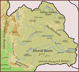
Geography
The Dong Phaya Yen Mountains consist mainly of a range of scattered medium-height hills stretching southwards of the Phetchabun Mountains in an arch until reaching the northern side of the Sankamphaeng Range. The mountain chain has a length of about 170 km and reaches a maximum elevation of 1,167 m at Phu Khing at the northern end. Other peaks are 900 m high Khao Phang Yai, 767 m high Khao Kheuan Lan, 782 m high Khao Cham Dot, 718 m high Khao Chalong Tong, 745 m high Khao Chan Luang, 722 m high Khao Lom, 722 m high Khao Sawong, 721 m high Khao Wong Chan Daeng, 689 m high Khao Phrik, 695 m high Khao Somphot, 657 m high Khao Kradon, 676 m high Khao Inthaya, 683 m high Khao Mot Ngam, 655 m high Khao Plai Khlong Kum, and 575 m high Khao Sadao.[3]
The northern limit of the Phetchabun massif is not clearly defined, roughly beginning south of the 16th parallel north where the ranges forming the Phetchabun system become a group of scattered mountains of lesser height, rarely surpassing 800 m, extending southwards. The eastern mountain chain of the Phetchabun Range is mentioned as the "Phang Hoei Range" in some geographical works,[4] a name that encompasses the whole northern section of the Dong Phaya Yen mountain system, for Khao Phang Hoei is a 1,008 m high summit west of Chaiyaphum town, beyond the southern end of the Phetchabun Range proper in the northern half of the Dong Phaya Yen.
The Dong Phaya Yen range divides the Chao Phraya river valley of central Thailand and the Khorat Plateau of the northeast. The mountains are drained to the east by several tributaries to the Chi and the Mun and to the west by tributaries of the Pa Sak River.
History
This whole mountainous region was covered by thick forest and was formerly known as Dong Phaya Fai or "jungle of the fire lord". There were no roads, hence it was not possible to use a cart. Travel across the forest had to be on foot or using palanquins. The whole area was reputed to be unhealthy and travelers who dared to pass through the woods exposed themselves to malaria and other illnesses. By the mid-19th century, when the clearing of the area began, Vice King (Uparaja) Pinklao changed the name of the forest from Dong Phaya Fai to Dong Phaya Yen to imply that "the wild forest had been tamed".
By 1887 the Siamese government decided to build a railway line from Bangkok to Korat through Ayutthaya and commissioned British Railway contractors to make a survey. The first section of what is now the Northeastern Line, the railway line to Korat across the mountains opened in 1900.[5] Much of the original forest cover of the mountains was destroyed since the beginning of 20th century. Following the completion of the line settlements were built in the area and trees were cut and land converted to agricultural use.
Until quite recently only the railroad from Bangkok to Nakhon Ratchasima and one highway crossed the system. Deforestation increased as the building of more roads connecting central Thailand and Isan began in earnest. Thailand Route 2, also known as "Mittraphap Road", the main road crossing the range between Saraburi and Nakhon Ratchasima, was built in 1950.
Protected areas
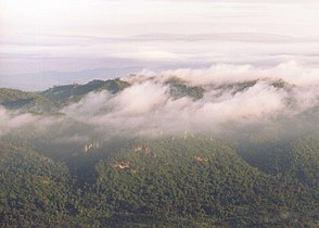
These mountains, together with the Sankamphaeng Range at their southern limit, form the Dong Phayayen-Khao Yai Forest Complex, which includes several national parks. This area was inscribed on the UNESCO World Heritage List in 2005. Altogether 6,155 km2 are protected in the complex. In mid-2016 UNESCO briefly considered placing the Dong Phayayen-Khao Yai Forest on a list of endangered World Heritage sites because Thailand had not done enough to stop illegal logging of phayung (Siamese rosewood) trees.[6][7]
Other protected areas in the Dong Phaya Yen mountains are:
- Pa Hin Ngam National Park
- Sai Thong National Park
- Phu Khiao Wildlife Sanctuary
- Tat Ton National Park
- Nam Phong National Park
- Phu Lan Ka National Park,[8]
- Sap Langka Wildlife Sanctuary
- Khao Somphot Non-hunting Area.[9]
Gallery
 The Luak ridge in morning fog with the Sonthi valley in front
 Rock formations at Pa Hin Ngam National Park
 Siam Tulip at Pa Hin Ngam National park
 Khao Kok Tako and the Pa Sak Cholasit Dam


See also
References
- The Caves of Lopburi - Caves & Caving in Thailand
- Land Use in Northeastern Thailand
- Map of Bangkok and 22 nearby provinces, PN Map
- Britannica Khorat Plateau
- A History of Thai Railways
- Jitcharoenkul, Prangthong (6 July 2016). "Govt to defend forest ranking". Bangkok Post. Retrieved 6 July 2016.
- "Unesco forest deemed not endangered, despite threats". Bangkok Post. 16 July 2016. Retrieved 16 July 2016.
- Phu Lan Ka National Park
- "Sap Langka Wildlife Sanctuary in Lopburi Thailand". Archived from the original on 2012-02-10. Retrieved 2012-02-23.
External links
| Wikimedia Commons has media related to Dong Phaya Yen Mountains. |
- New Liphistius species (Araneae, Mesothelae) from western and eastern Thailand doi:10.1111/j.1463-6409.1996.tb00155.x
- The Northeast
- Royal State Railways of Siam - History
На других языках
[de] Dong Phaya Yen
Dong Phaya Yen (thailändisch .mw-parser-output .Thai{font-size:115%}ป่าดงพญาเย็น, wörtl. „Dschungel des Herrn der Kälte“) ist eine Bergkette in Zentralthailand. Die Berge des Dong Phaya Yen stellen die südöstliche Verlängerung des Phetchabun-Gebirges dar und trennen das Tal des Chao-Phraya-Stromes von der Khorat-Hochebene in der Nordostregion des Landes (Isan). Sie ziehen sich über eine Länge von etwa 230 Kilometern hin und werden nach Süden von der Sankamphaeng-Bergkette (ทิวเขาสันกำแพง) und nach Osten von den Dângrêk Bergen fortgeführt.- [en] Dong Phaya Yen Mountains
[es] Montañas Dong Phaya Yen
Dong Phaya Yen o Dong Phya Yen [1] ( en tailandés, ทิวเขาดงพญาเย็น, lit. "selva del señor del frío") es una cadena montañosa en las provincias de Phetchabun, Chaiyaphum, Lopburi, Saraburi y Nakhon Ratchasima, Tailandia .[fr] Montagnes de Dong Phaya Yen
Les montagnes de Dong Phaya Yen (en thaï : ดงพญาเย็น, littéralement « Jungle du maître de la glace »), sont une chaîne de montagnes des provinces de Chaiyaphum, Lopburi, Saraburi et Nakhon Ratchasima au centre de la Thaïlande. C'est une extension du sud-ouest des monts Phetchabun, qui sépare le bassin de la Chao Phraya et le plateau de Khorat. Longue de 170 km, la chaîne est continuée au sud par les monts de Sankamphaeng.[it] Dong Phayayen
Dong Phayayen ((TH) ดงพญาเย็น, Giungla del Signore di Ghiaccio) è una delle catene montuose della Thailandia che segnano il confine tra la parte centrale e il Nord-est del Paese. È un'estensione verso sud dei monti Phetchabun, e separa la valle del fiume Chao Phraya dall'altopiano di Korat, nel nord-est del paese. Ha una lunghezza di circa 170 chilometri sull'asse nord-sud, e prosegue verso sud-est con i monti Sankamphaeng.[ru] Донгфаяйен
Донгфаяйен[1] (тайск. ป่าดงพญาเย็น — «джунгли властелина холода») — горная система в центральном Таиланде. Представляют собой продолжение хребта Пхетчабун и разделяют долины Чаупхрайи от плато Корат. Длина гор — 230 километров, на юг они продолжаются как горы Санкамбенг, и далее на восток — Дангрек. На севере массив расположен в бассейне реки Мун, на юге — Меконга. высота массива от 100 до 1350 метров, высшая точка, гора Кхао-Ром имеет высоту 1351 метр.Другой контент может иметь иную лицензию. Перед использованием материалов сайта WikiSort.org внимательно изучите правила лицензирования конкретных элементов наполнения сайта.
WikiSort.org - проект по пересортировке и дополнению контента Википедии