geo.wikisort.org - River
The Mun River (Thai: แม่น้ำมูล, RTGS: Maenam Mun, pronounced [mɛ̂ː.náːm mūːn]), sometimes spelled Moon River, is a tributary of the Mekong River. It carries approximately 26 cubic kilometres (6.2 cu mi) of water per year.
| Mun River | |
|---|---|
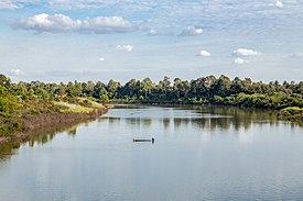
 The Mun River in Rasi Salai Dam during dry season, Rasi Salai District, Sisaket Province | |
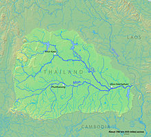
 Map of the Mun River drainage basin | |
| Native name | แม่น้ำมูล (Thai) |
| Location | |
| Country | Thailand |
| Physical characteristics | |
| Source | |
| • location | Nakhon Ratchasima |
| • elevation | 530 m (1,740 ft) |
| Mouth | Mekong River |
• location | Amphoe Khong Chiam, Ubon Ratchathani province |
• coordinates | 15°19′14″N 105°30′29″E |
• elevation | 97 m (318 ft) |
| Length | 900 km (560 mi) |
| Basin size | 119,180 km2 (46,020 sq mi) |
| Discharge | |
| • location | Mekong River, Ubon Ratchathani |
| • average | 725 m3/s (25,600 cu ft/s) |
| • maximum | 10,015 m3/s (353,700 cu ft/s) |
| Basin features | |
| Tributaries | |
| • left | Chi River |
| • right | Lam Dom Noi |
| Longest source length: Chi River: 1047 km ⟶ Mun River: 115 km ⟶ Mekong River: Total: 1,162 km | |
Geography

The river begins in the Khao Yai National Park area of the Sankamphaeng Range, near Nakhon Ratchasima in northeast Thailand. It flows east through the Khorat Plateau in southern Isan (Nakhon Ratchasima, Buriram, Surin, and Sisaket Provinces) for 750 kilometres (466 mi), until it joins the Mekong at Khong Chiam in Ubon Ratchathani. The Mun River's main tributary is the Chi River, which joins it in the Kanthararom District of Sisaket Province.
History
Thanks to the Andy Williams hit song, the Mun River was called "Moon River" by US Air Force personnel stationed at Ubon Ratchathani airbase during the Vietnam War. The spelling is still fairly common.[1]
The controversial Pak Mun Dam, which is charged with causing environmental damage,[2] is near the river's confluence with the Mekong.
Tributaries
References
- Ubon RTAFB - U.S. Air Force[not specific enough to verify]
- "Rivers of the World - the Mun River in Thailand", Radio Netherlands Archives, November 1, 2002
External links
![]() Media related to Mun River at Wikimedia Commons
Media related to Mun River at Wikimedia Commons
На других языках
[de] Mae Nam Mun
Der Mae Nam Mun (Thai: .mw-parser-output .Thai{font-size:115%}แม่น้ำมูล, Aussprache: .mw-parser-output .IPA a{text-decoration:none}[mɛ̂ː náːm muːn]), oder nur Mun, ist ein Fluss in der Nordostregion von Thailand, dem so genannten Isan, und der größte Zufluss für den Mekong mit durchschnittlich 725 m³/s. Sein Einzugsgebiet erstreckt sich über etwa 69.700 km² und liegt in den Provinzen Nakhon Ratchasima, Buri Ram, Roi Et, Surin, Si Sa Ket und Ubon Ratchathani. Hier finden sich zahlreiche Tier- und Pflanzenarten: mehr als 50 Vogelarten, mehr als 100 Fischarten und 7 Pflanzenarten.[1]- [en] Mun River
[it] Mun (fiume)
Il fiume Mun (in lingua thai: แม่น้ำมูล; trascrizione RTGS: Maenam Mun, IPA: /mɛː naːm muːn/) è un affluente di destra del fiume Mekong e attraversa la parte meridionale della Thailandia del Nordest. Bagna la periferia orientale di Nakhon Ratchasima e quella meridionale di Ubon Ratchathani, due delle maggiori città della regione. È a tratti navigabile e le sue acque, particolarmente ricche di pesce, sono impiegate anche per l'irrigazione.[1][ru] Мун (река)
Мун, Наммун[1] (тайск. แม่น้ำมูล) — река в Таиланде, один из притоков Меконга.Другой контент может иметь иную лицензию. Перед использованием материалов сайта WikiSort.org внимательно изучите правила лицензирования конкретных элементов наполнения сайта.
WikiSort.org - проект по пересортировке и дополнению контента Википедии