geo.wikisort.org - River
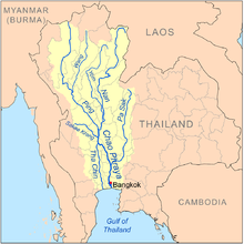
The Pa Sak River (Thai: แม่น้ำป่าสัก, RTGS: Maenam Pa Sak, IPA: [mɛ̂ːnáːm pàː sàk], Pronunciation) is a river in central Thailand. The river originates in the Phetchabun Mountains, Dan Sai District, Loei Province, and passes through Phetchabun Province as the backbone of the province. It then passes through the eastern part of Lopburi Province and Saraburi Province, until it joins the Lopburi River northeast of Ayutthaya Island, before it runs into the Chao Phraya River southeast of Ayutthaya near Phet Fortress. It has a length of 513 km (319 mi) and drains a watershed of 16,291 km2 (6,290 sq mi). The annual discharge is 2.4 km3 (0.58 cu mi).
This article needs additional citations for verification. (January 2021) |
| Pa Sak River (แม่น้ำป่าสัก) | |
|---|---|
 The Pa Sak River flowing east of Ayuttaya's old city | |
| Location | |
| Country | Thailand |
| Physical characteristics | |
| Source | |
| • location | Phetchabun Mountains |
| Mouth | |
• location | Chao Phraya River at Ayutthaya Island |
| Length | 513 km (319 mi) |
| Basin size | 16,291 km2 (6,290 sq mi) |
| Discharge | |
| • average | 2.4 km3 (0.58 cu mi)/yr |
The valley of the Pa Sak through the Phetchabun mountains is a dominant feature of Phetchabun Province. Water levels vary seasonally. To address drought problems in the lower Pa Sak valley, in 1994 the construction of the Pa Sak Cholasit Dam (เขื่อนป่าสักชลสิทธิ์) in Lopburi Province was built. The 4,860-meter (15,940 ft) wide and 36.5-meter (120 ft) high dam retains 0.785 km3 (0.188 cu mi) of water. The dam also supplies about 6.7 MW of electricity.
Tributaries
Tributaries of the Pa Sak include the Lopburi River, Khlong Muak Lek, Huai Nam Phung, Huai Pa Daeng, Khlong Lam Kong, Lam Sonthi, Khlong Wang Chomphu, Khlong Huai Na, Huai Nam Chun, Huai Nam Duk, Huai Khon Kaen, Huai Yai, Khlong Saduang Yai, Khlong Ban Bong, Khlong Tarang, and Lam Phaya Klang.
Pa Sak Basin
The Pa Sak drains an area of 16,291 square kilometres (6,290 sq mi).[1] The Pa Sak Basin is part of the Chao Phraya watershed.
References
- "Basins of Thailand". Retrieved 2008-03-29.[dead link]
External links
На других языках
[de] Mae Nam Pa Sak
Der Mae Nam Pa Sak (Thai: .mw-parser-output .Thai{font-size:115%}แม่น้ำป่าสัก; oder nur Pa Sak, auch Pasak geschrieben) ist ein Fluss im nördlichen Zentralthailand. Er ist ein Nebenfluss des Mae Nam Chao Phraya (Chao-Phraya-Fluss).- [en] Pa Sak River
[es] Río Pa Sak
El río Pa Sak (en tailandés: แม่น้ำ ป่า สัก) es un río en el centro de Tailandia. Nace en el Amphoe de Dan Sai, provincia de Loei, pasa a través de la provincia de Phetchabun como la columna vertebral de la misma. A continuación atraviesa la parte oriental de la provincia de Lopburi y la de Saraburi, hasta que se une al río Lopburi en el noreste de la isla de Ayutthaya, antes de que se encuentren con el Chao Phraya en el sureste. Tiene una longitud de 513 km y drena una cuenca de 16.291 km², transportando 2,4 km³ de agua al año.[it] Pa Sak
Il Pa Sak (in thailandese: แม่น้ำป่าสัก?, traslitterato: Mènam Pasak, letteralmente: foresta di teck[2]) è un affluente di sinistra del fiume Chao Phraya, in Thailandia. Scorre per 513km e sfocia nel Chao Phraya alla periferia di Ayutthaya.[ru] Пасак (река)
Паса́к[1][2] (тайск. แม่น้ำป่าสัก[3]) — река в Таиланде, левый приток Чаупхрая[2].Другой контент может иметь иную лицензию. Перед использованием материалов сайта WikiSort.org внимательно изучите правила лицензирования конкретных элементов наполнения сайта.
WikiSort.org - проект по пересортировке и дополнению контента Википедии