geo.wikisort.org - River
The Papar River (Malay: Sungai Papar) is a river in West Coast Division, northwestern Sabah of Malaysia. It has a total length of 60 km (37 mi) from its headwaters in the mountains of northwest Sabah to its outlet at the South China Sea, northwest of Papar town. Its source is originated from the mountains in the interior Papar, Penampang and Tuaran Districts, which part of the Crocker Range system.[3] These includes the area of Babagon, Bonobukan, Buayan, Central Papar, Gramatoi, Himpangno, Kaiduan, Kalangan, Kawari, Kogopon, Lingan, Mandalipau, Marahang, Padawan, Terian, Tiku and Ulu Papar.[1]
| Papar River | |
|---|---|
 View of the river. | |
| Native name | Sungai Papar (Malay) |
| Location | |
| Country | |
| State | |
| Division | West Coast Division |
| Precise location | Northwestern Borneo |
| Physical characteristics | |
| Source | |
| • location | From mountains in Papar, Penampang and Tuaran Districts |
| Mouth | |
• location | At Papar District into South China Sea |
• coordinates | 5°45′08.6″N 115°54′29.9″E |
• elevation | Sea level |
| Length | 60 km (37 mi)[1] |
| Basin size | 805 km2 (311 sq mi)[1][2] |
| Basin features | |
| River system | Crocker Range[1][3] |
History

Through the era of the thalassocratic Bruneian Sultanate, the latter appointed Bruneian Malay nobility as the Sultan's representative in the interior and major rivers which includes the Papar River.[4] Before the arrival of the North Borneo Chartered Company in the 19th century, the fertile valley around the river provide a sizeable farming community among the local indigenous.[5] Through a survey conducted during the voyage of HMS Samarang (1822) under Edward Belcher along the northwestern coast of Borneo between 1843–1846, the British found the river mouth is located not far from Dinawan Island.[6] The river become the transportation route for many Bruneian Malay and Kadazan villages situated along the river banks before bitumen roads and railway as a modern transportation networks being introduced by the British following their arrival.[5] The small town of Papar owes its existence to the river after which it was named.[5]

A first bridge for crossing the river was built in 1901 under the administration of the British together with other iron bridges in Kimanis and Membakut.[7] However, it was swept by strong floods into the river where it was replaced with a new iron bridge but also damaged by another floods in 1903.[8] A ferry service was temporarily made while the bridge undergoing repair. In 1904, another strong floods damaging the currently repaired bridge with most of its structure been swept away. A temporary bridge constructed in November 1908 also being swept away by floods.[9] Finally in December 1908, a new bridge was constructed but again damaged by floods in 1913.[10] In 1915, the railway service finally make its way to the Papar town with the opening of a railway bridge.

During the World War II, the railway bridge was however destroyed by Allied bombings to prevent it being used by the Japanese with the site also becoming one of the area where the Imperial Japanese Army surrendering to the Australian Imperial Force.[11][12] After the end of the war, the locals need to use small boats to transport people and goods on the other side of the river without the bridge.[5] A new bridge was later constructed although many rumours began to spread around at the time before the bridge construction that to ensure a successful construction of its structure, human heads must be buried at the foundation of the bridge with many locals believed that head hunters would be sent out to look for victims at night that causing everyone to be vigilant.[5]
Since the existent of the railway bridge, another bridge for vehicle was located beside the rail bridge. Since the 2010s, there have been persistent calls to refurbish the bridge since its present condition is unable to afford large traffic which causing daily traffic congestion among Papar residents and people from other places.[13] Another bridge called the Salleh Sulong Bridge which will be replaced by a newer bridge as part of the Pan Borneo Highway project is located in Old Papar Road at 5°41′38″N 115°59′15″E. The bridge is supported by newer concrete bridge which has been opened in 2018.[14]
Conservation efforts
Much of the river is covered by mangrove palm and swamps and that providing natural coastal protection and habitat for several bird species. Since the 2000s, the coasts of the river was affected by sand mining activities with 11 identified locations.[15] Beginning in the 2010s, the Sabah government through the Lands and Surveys Department (LSD) began to increase operation against illegal sand mining in Papar as well on Tuaran River.[16]
Features
The river is among the largest in terms of water discharge other than Kinabatangan and Padas rivers.[17] It is important as the source of freshwater fish and providing water for agriculture activities of the villagers as well commercial farms along the river and for Papar town respectively.[18]
 Vehicle bridge beside the oldest railway bridge.
 Fishermen unloading supplies from their boat in the river.
 Signboard of the river name on the Salleh Sulong Bridge (replaced with new structure, estimated to be completed in 2020).
 The river seen from the Salleh Sulong Bridge.
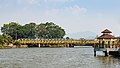 The railway bridge (in yellow) as seen today beside another bridge for vehicle.


See also
References
- "Papar Profile" (PDF). Department of Irrigation and Drainage, Malaysia. 2011. p. 13/38. Archived from the original (PDF) on 24 May 2019. Retrieved 6 July 2019.
- "National Register of River Basins [List of River Basin Management Units (RBMU) – Sabah]" (PDF). Department of Irrigation and Drainage, Malaysia. 2003. p. 34. Retrieved 6 July 2019.
- "Crocker Range [Data Zone MY020]". BirdLife International. 2003. Retrieved 6 July 2019.
{{cite journal}}: Cite journal requires|journal=(help) - Dayang Junaidah Awang Jambol (2018). "Hubungan Tradisi Brunei dengan Borneo Utara: Tinjauan Terhadap Faktor Kemerosotan Pentadbiran Kesultanan Brunei pada Abad Ke-19" [The Relationship Tradition of Brunei and North Borneo: A Review of the Depreciation Factor of the Brunei Sultanate in the 19th Century] (PDF). Jurnal Borneo Arkhailogia (Heritage, Archaeology and History) (in Malay). 3 (2): 109 – via Universiti Malaysia Sabah.
- Chung Mui Kong (4 August 2013). Little Snapshots. BookBaby. p. 206–217. ISBN 978-0-9922955-1-6.
- Edward Belcher (30 June 2011). Narrative of the Voyage of HMS Samarang, During the Years 1843-46: Employed Surveying the Islands of the Eastern Archipelago. Cambridge University Press. p. 144. ISBN 978-1-108-02923-0.
- British North Borneo Herald 1901.
- British North Borneo Herald 1903.
- British North Borneo Herald 1908.
- British North Borneo Herald 1913.
- Civil Engineering and Public Works Review. Lomax, Erskine & Company. 1952.
- "Australian invasion of Borneo in pictures". Asian Railways. Retrieved 7 July 2019.
- "Historic Buang Sayang bridge needs a facelift". Daily Express. 22 May 2015. Archived from the original on 7 July 2019. Retrieved 7 July 2019.
- "Jambatan pertama projek lebuh raya Pan Borneo Sabah dibuka" [The first bridge of the Pan Borneo Sabah highway project was opened]. Bernama (in Malay). Astro Awani. 16 November 2018. Archived from the original on 7 July 2019. Retrieved 7 July 2019.
- "Environmental Impact Assessment (EIA) Guidelines for River Sand and Stone Mining" (PDF). State Environmental Conservation Department (ECD). 2000. p. 9 [9/60]. Archived from the original (PDF) on 8 July 2019. Retrieved 8 July 2019 – via Government of Sabah.
- "Machinery seized over illegal sand mining". The Borneo Post. 21 May 2016. Archived from the original on 8 July 2019. Retrieved 8 July 2019.
- "Sabah Biodiversity Conservation Strategy" (PDF). Government of Sabah, Universiti Malaysia Sabah and Japan International Cooperation Agency. p. A2-13 [37/202]. Archived from the original (PDF) on 7 July 2019. Retrieved 7 July 2019 – via Government of Sabah.
- "Integrated Shoreline Management Plan for Negeri Sabah [Final Report]" (PDF). Department of Irrigation and Drainage, Malaysia. 2013. p. 7-1 [58/66]. Archived from the original (PDF) on 7 July 2019. Retrieved 8 July 2019 – via Government of Sabah.
- British North Borneo Herald (1901). British North Borneo Herald. British North Borneo.
- British North Borneo Herald (1903). British North Borneo Herald. British North Borneo.
- British North Borneo Herald (1908). British North Borneo Herald. British North Borneo.
- British North Borneo Herald (1913). British North Borneo Herald. British North Borneo.
Further reading
- "Kompendium (Data dan Maklumat Asas JPS)" [Compendium (DID Basic Data and Information)] (PDF) (in Malay). Department of Irrigation and Drainage, Malaysia. 2018: 26. Archived from the original (PDF) on 24 May 2019. Retrieved 6 July 2019.
{{cite journal}}: Cite journal requires|journal=(help)
External links
 Media related to Papar River at Wikimedia Commons
Другой контент может иметь иную лицензию. Перед использованием материалов сайта WikiSort.org внимательно изучите правила лицензирования конкретных элементов наполнения сайта.
WikiSort.org - проект по пересортировке и дополнению контента Википедии