geo.wikisort.org - River
The Padas River (Malay: Sungai Padas) is a river in Interior Division, southwestern Sabah of Malaysia. It has a total length of 120 km (75 mi) from its headwaters in the mountains of northwest Sabah to its outlet at the South China Sea, southwest of Beaufort town. Its source is originated from the mountains in the interior Beaufort, Keningau and Tenom Districts, which part of the Crocker Range system.[4]
| Padas River | |
|---|---|
 View of the river. | |
| Native name | Sungai Padas (Malay) |
| Location | |
| Country | |
| State | |
| Division | Interior Division |
| Precise location | Northwestern Borneo |
| Physical characteristics | |
| Source | |
| • location | From mountains in Beaufort, Keningau and Tenom Districts |
| Mouth | |
• location | At Beaufort District into South China Sea |
• coordinates | 5°10′50.4″N 115°33′36.7″E |
• elevation | Sea level |
| Length | 120 km (75 mi)[1] |
| Basin size | 9,180 km2 (3,544 sq mi)[2] |
| Basin features | |
| River system | Crocker Range[3][4] |
Features
The river is important to provide water supply to Labuan and both districts of Beaufort and Tenom including as the main source of hydroelectric power to entire west coast of Sabah.[3] The river is among the destination for water rafting activities in Sabah aside from Liwagu and Kiulu River.[5][6]
 Rocks in the river.
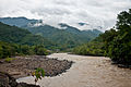 The river view from Padas Valley.
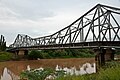 Vehicle bridge passing the river in Beaufort.
 Water rafting activities in the river whitewater.


See also
Further reading
- "Kompendium (Data dan Maklumat Asas JPS)" [Compendium (DID Basic Data and Information)] (PDF) (in Malay). Department of Irrigation and Drainage, Malaysia. 2018: 26. Archived from the original (PDF) on 24 May 2019. Retrieved 16 July 2019.
{{cite journal}}: Cite journal requires|journal=(help)
References
- "Japan Study on Power Demands in Sabah" (PDF). p. 12/107 [2-2]. Archived from the original (PDF) on 16 July 2019. Retrieved 16 July 2019 – via Japan International Cooperation Agency.
- "National Register of River Basins [List of River Basin Management Units (RBMU) – Sabah]" (PDF). Department of Irrigation and Drainage, Malaysia. 2003. p. 34. Retrieved 16 July 2019.
- "SBCP - Identification of Potential Protected Areas Ulu Padas - (Final Report) » Background on Biodiversity Significance" (PDF). p. 6/63. Archived from the original (PDF) on 9 April 2016. Retrieved 16 July 2019 – via Ministry of Culture, Environment and Tourism, Government of Sabah.
- "Crocker Range [Data Zone MY020]". BirdLife International. 2003. Retrieved 17 July 2019.
{{cite journal}}: Cite journal requires|journal=(help) - "Padas Rafting". Sabah Education Department. Archived from the original on 17 July 2019. Retrieved 17 July 2019.
- Hafiz Ithnin (3 April 2018). "'Jump! Jump!', 'Boom! Boom!' [METROTV]" (in Malay). Harian Metro. Retrieved 17 July 2019.
External links
 Media related to Padas River at Wikimedia Commons
На других языках
[de] Sungai Padas
Der Padas (mal. Sungai Padas) oder Padas River ist ein Fluss im malaysischen Bundesstaat Sabah auf Borneo. Er entspringt im südwestlichen Sabah, im Grenzgebiet zu Indonesien und Sarawak und verläuft aus dem Hochland bis zur Mündung bei Weston in die Padas-Bucht, die wiederum zum Südchinesischen Meer gehört. Im Mündungsgebiet mäandriert der Fluss stark. Der Padas mit seinen Quell- und Nebenflüssen entwässert ein Gebiet von 7720 km².[1]- [en] Padas River
Текст в блоке "Читать" взят с сайта "Википедия" и доступен по лицензии Creative Commons Attribution-ShareAlike; в отдельных случаях могут действовать дополнительные условия.
Другой контент может иметь иную лицензию. Перед использованием материалов сайта WikiSort.org внимательно изучите правила лицензирования конкретных элементов наполнения сайта.
Другой контент может иметь иную лицензию. Перед использованием материалов сайта WikiSort.org внимательно изучите правила лицензирования конкретных элементов наполнения сайта.
2019-2026
WikiSort.org - проект по пересортировке и дополнению контента Википедии
WikiSort.org - проект по пересортировке и дополнению контента Википедии