geo.wikisort.org - River
The Tuaran River (Malay: Sungai Tuaran) is a river in West Coast Division, northwestern Sabah of Malaysia. It has a total length of 80 km (50 mi) from its headwaters in the mountains of northwest Sabah to its outlet at the South China Sea, northwest of Tuaran town.
| Tuaran River | |
|---|---|
 View of the river. | |
| Native name | Sungai Tuaran (Malay) |
| Location | |
| Country | |
| State | |
| Division | West Coast Division |
| Precise location | Northwestern Borneo |
| Physical characteristics | |
| Source | |
| • location | From mountains in Tuaran District |
| Mouth | |
• location | At Tuaran District into South China Sea |
• coordinates | 6°13′19.3″N 116°11′10.0″E |
• elevation | Sea level |
| Length | 80 km (50 mi) |
| Basin size | 988 km2 (381 sq mi)[1][2] |
| Basin features | |
| River system | Crocker Range[1] |
History
The small town of Tuaran owes its existence to the river after which it was named.[3] The river is also part of the route where British colonial administrator Hugh Low began his journey for the first recorded ascention of North Borneo's highest point of Mount Kinabalu, having depart from Labuan in 1851.[4][5][6]
Conservation efforts
Much of the river is covered by mangrove palm and swamps that providing natural coastal protection and habitat for several bird species. It is home to saltwater crocodiles (Crocodylus porosus) and notable for many crocodile incidents.[7] Since the 2000s, the coasts of the river was affected by sand mining activities with 14 identified locations.[8] Beginning in the 2010s, the Sabah government through the Lands and Surveys Department (LSD) began to increase operation against illegal sand mining in Tuaran as well on Papar River.[9]
Features
The river is the freshwater fish source for the villagers and the source of water for their agriculture activities.
 The river seen from afar.
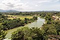 The river view from Ling San Pagoda.


See also
References
- Jayawati Montoi; Siti Rahayu Mohd. Hashim; Sanudin Tahir (2017). "A Study on Tuaran River Channel Planform and the Effect of Sand Extraction on River Bed Sediments" (PDF). Transactions on Science and Technology. 4 (4): 443 [2/7]. ISSN 2289-8786. Archived from the original (PDF) on 9 July 2019. Retrieved 8 July 2019.
- "National Register of River Basins [List of River Basin Management Units (RBMU) – Sabah]" (PDF). Department of Irrigation and Drainage, Malaysia. 2003. p. 34. Retrieved 9 July 2019.
- "Sejarah/Asal Usul Daerah Tuaran" [History/Origin of Tuaran District] (in Malay). Tuaran District Council. Archived from the original on 11 July 2019. Retrieved 11 July 2019.
- Royal Geographical Society (Great Britain) (1888). Proceedings of the Royal Geographical Society and Monthly Record of Geography. Edward Stanford. p. 144.
- K. M. Wong; Anthea Phillipps (1 January 1996). Kinabalu, Summit of Borneo. Sabah Society. p. 41. ISBN 978-967-99947-4-2.
- Shui Hiung Chin; Ravi Mandalam; Christopher Chin (2004). The Hugh Low trail: the quest for the historical trail to the summit of Kinabalu. Sabah Society. p. 9. ISBN 978-967-99947-8-0.
- Fanny Lai; Bjorn Olesen (16 August 2016). Visual Celebration of Borneo's Wildlife. Tuttle Publishing. p. 113. ISBN 978-1-4629-1907-9.
- "Environmental Impact Assessment (EIA) Guidelines for River Sand and Stone Mining" (PDF). State Environmental Conservation Department (ECD). 2000. p. 9 [9/60]. Archived from the original (PDF) on 8 July 2019. Retrieved 12 July 2019 – via Government of Sabah.
- "Machinery seized over illegal sand mining". The Borneo Post. 21 May 2016. Archived from the original on 8 July 2019. Retrieved 12 July 2019.
Further reading
- "Kompendium (Data dan Maklumat Asas JPS)" [Compendium (DID Basic Data and Information)] (PDF) (in Malay). Department of Irrigation and Drainage, Malaysia. 2018: 26. Archived from the original (PDF) on 24 May 2019. Retrieved 9 July 2019.
{{cite journal}}: Cite journal requires|journal=(help)
External links
 Media related to Tuaran River at Wikimedia Commons
Другой контент может иметь иную лицензию. Перед использованием материалов сайта WikiSort.org внимательно изучите правила лицензирования конкретных элементов наполнения сайта.
WikiSort.org - проект по пересортировке и дополнению контента Википедии