geo.wikisort.org - Island
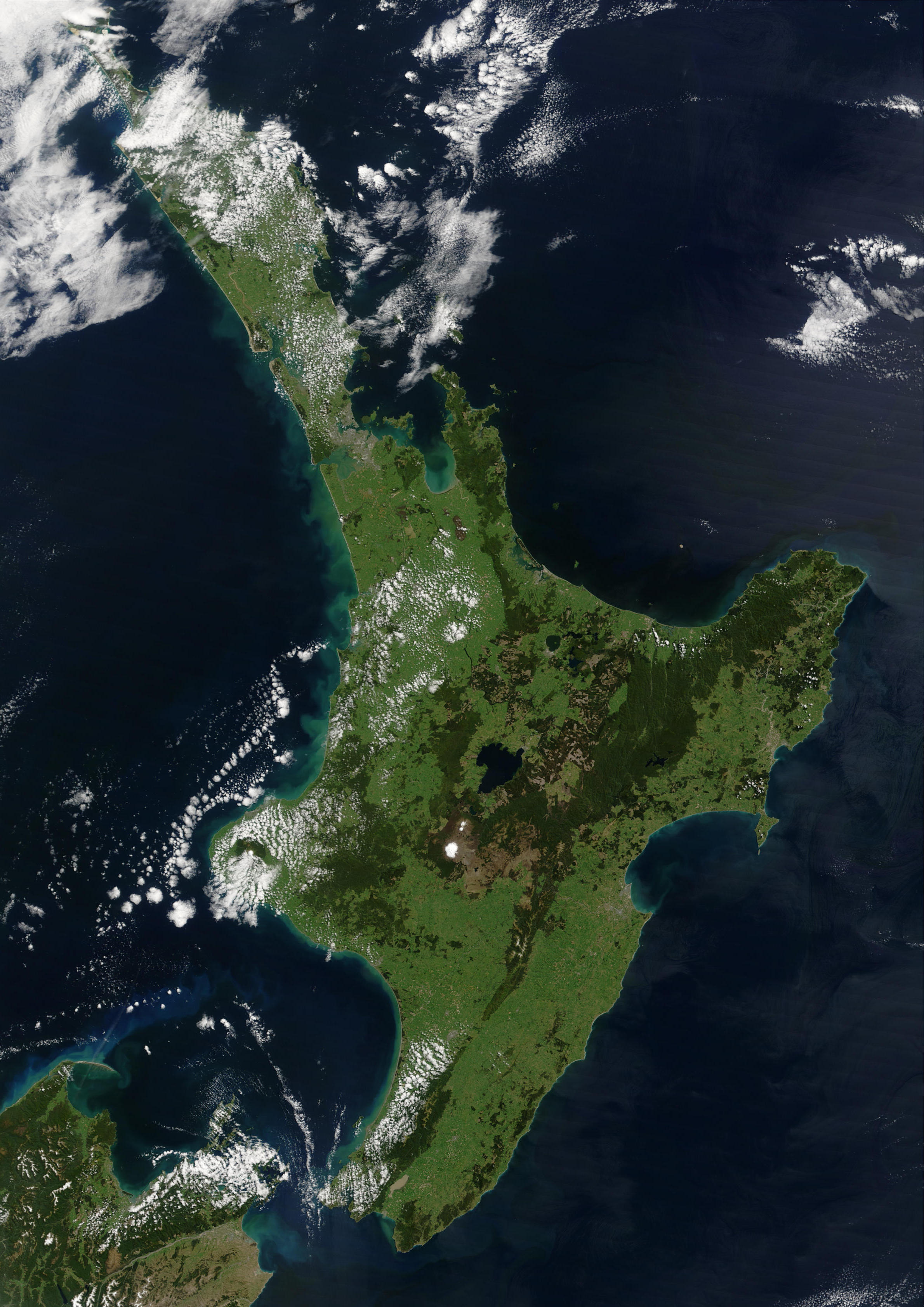
The North Island, also officially named Te Ika-a-Māui,[1] is one of the two main islands of New Zealand, separated from the larger but much less populous South Island by the Cook Strait. The island's area is 113,729 square kilometres (43,911 sq mi),[2] making it the world's 14th-largest island. It has a population of 3,922,000 (June 2022),[3] accounting for approximately 77% of the total residents of New Zealand.[4]
 | |
 North Island | |
| Geography | |
| Location | Oceania |
| Coordinates | 38°24′S 175°43′E |
| Archipelago | New Zealand |
| Area | 113,729 km2 (43,911 sq mi) |
| Area rank | 14th |
| Highest elevation | 2,797 m (9177 ft) |
| Highest point | Mount Ruapehu |
| Administration | |
New Zealand | |
| ISO 3166-2:NZ | NZ-N |
| Regions | 9 |
| Territorial authorities | 43 |
| Largest settlement | Auckland (pop. 1,440,300) |
| Demographics | |
| Population | 3,922,000 (June 2022) |
| Pop. density | 34.5/km2 (89.4/sq mi) |
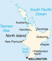
Twelve main urban areas (half of them officially cities) are in the North Island. From north to south, they are Whangārei, Auckland, Hamilton, Tauranga, Rotorua, Gisborne, New Plymouth, Napier, Hastings, Whanganui, Palmerston North, and New Zealand's capital city Wellington, which is located at the south-west tip of the island.
Naming and usage
Although the island has been known as the North Island for many years,[5] in 2009 the New Zealand Geographic Board found that, along with the South Island, the North Island had no official name.[6] After a public consultation, the board officially named the island North Island or Te Ika-a-Māui in October 2013.[7]
In prose, the two main islands of New Zealand are called the North Island and the South Island, with the definite article.[8] It is also normal to use the preposition in rather than on, for example "Hamilton is in the North Island", "my mother lives in the North Island".[9] Maps, headings, tables, and adjectival expressions use North Island without "the".
Māori mythology
According to Māori mythology, the North and South Islands of New Zealand arose through the actions of the demigod Māui. Māui and his brothers were fishing from their canoe (the South Island) when he caught a great fish and pulled it right up from the sea. While he was not looking his brothers fought over the fish and chopped it up. This great fish became the North Island and thus a Māori name for the North Island is Te Ika-a-Māui ("The Fish of Māui").[10] The mountains and valleys are believed to have been formed as a result of Māui's brothers' hacking at the fish.
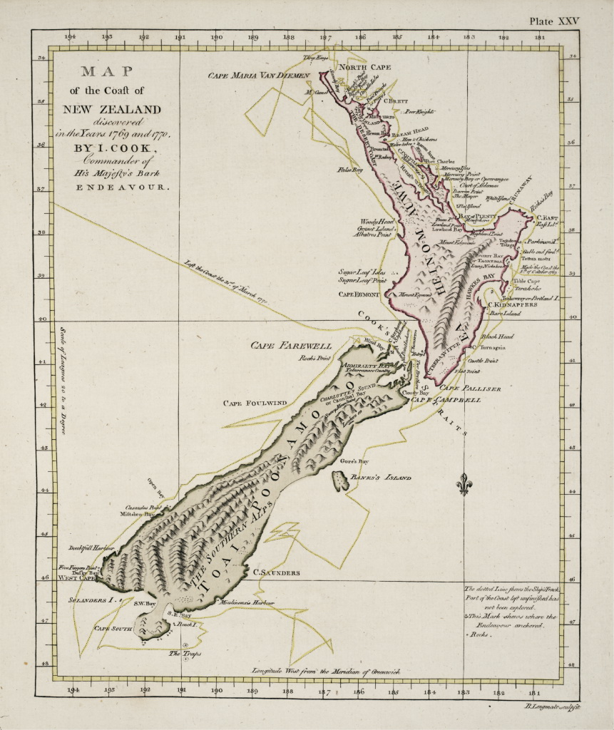
During Captain James Cook's voyage between 1769 and 1770, Tahitian navigator Tupaia accompanied the circumnavigation of New Zealand. The maps described the North Island as "Ea Heinom Auwe" and "Aeheinomowe", which recognises the "Fish of Māui" element. Despite this, revisionist historians and Ngai Tahu[11] argue that, until the early 20th Century, Aotearoa was an alternative Māori name for the North Island. In present usage, Aotearoa is a collective Māori name for New Zealand as a whole.[12]
Geography
During the Last Glacial Period when sea levels were over 100 metres lower than present day levels, the North and South islands were connected by a vast coastal plain which formed at the South Taranaki Bight.[13] During this period, most of the North Island was covered in thorn scrubland and forest, while the modern-day Northland Peninsula was a subtropical rainforest.[14] Sea levels began to rise 7,000 years ago, eventually separating the islands and linking the Cook Strait to the Tasman Sea.[13]
Bays and coastal features
- Bay of Islands
- Bay of Plenty
- Hauraki Gulf
- Firth of Thames
- Hawke Bay
- Ninety Mile Beach
- North Taranaki Bight
- South Taranaki Bight
Lakes and rivers
Capes and peninsulas
Forests and national parks

- Egmont National Park
- Tongariro National Park
- Waipoua Kauri Forest
- Whanganui National Park
- and many forest parks of New Zealand
Volcanology
- Auckland Volcanic Field
- Mount Ruapehu
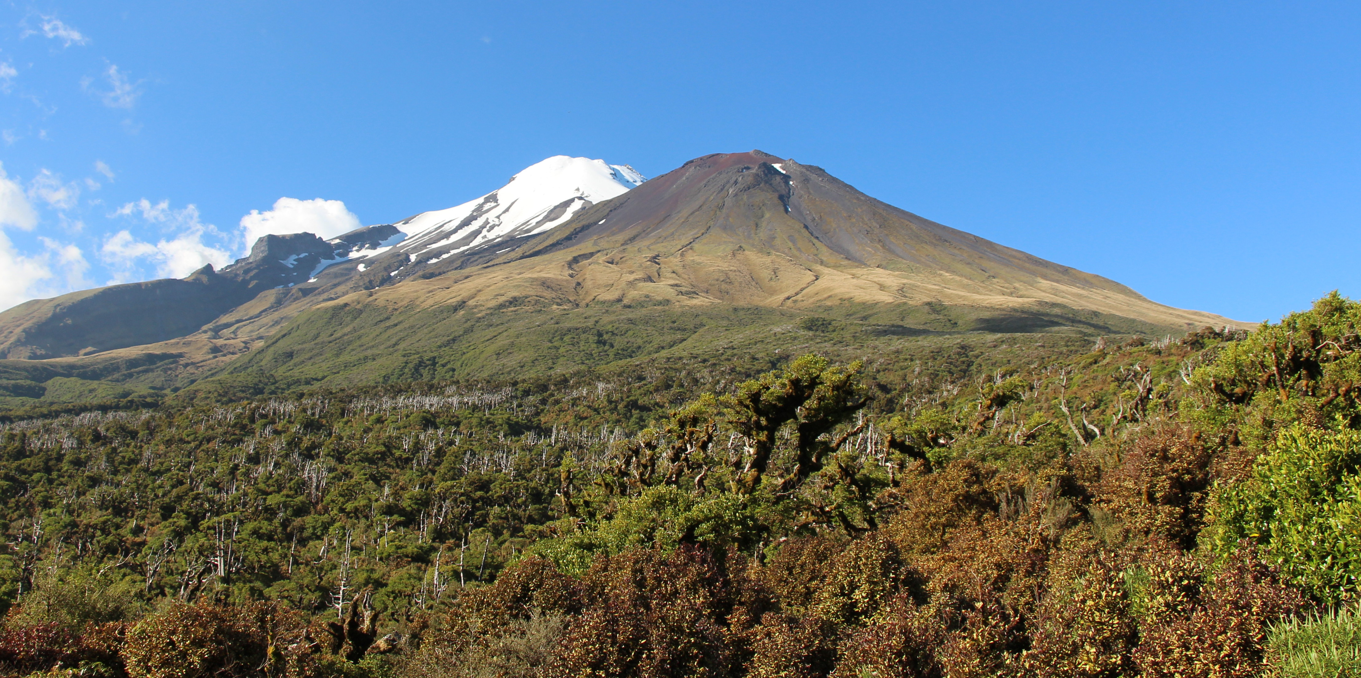
- Mount Taranaki (Taranaki Maunga)
- Mount Tarawera
- Whakaari / White Island
- North Island Volcanic Plateau
Other
- Waitomo Caves
- Taumatawhakatangihangakoauauotamateaturipukakapikimaungahoronukupokaiwhenuakitanatahu
Demographics
The North Island has an estimated population of 3,922,000 as of June 2022.[3]
Ever since the conclusion of the Otago Goldrush in the 1860s, New Zealand's European population growth has experienced a steady 'Northern drift' as population centres in the North Island have grown faster than those of New Zealand's South Island. This population trend has continued into the twenty-first century, but at a much slower rate. While the North Island population continues to grows faster than the South Island, this is solely due to the North Island having higher natural increase (i.e. births minus deaths) and international migration; since the late 1980s, the internal migration flow has been from the North Island to the South Island.[15] In the year to June 2020, the North Island gained 21,950 people from natural increase and 62,710 people from international migration, while losing 3,570 people from internal migration.[16]
Culture and identity
At the 2018 New Zealand census, 65.7% of North Islanders identified as of European ethnicity, 18.5% as Māori, 17.0% as Asian, 9.7% as Pacific Islanders, 1.6% as Middle Eastern/Latin American/African, and 1.2% as another ethnicity (mainly 'New Zealander'). Totals add to more than 100% since people may identify with multiple ethnicities.[17]
The proportion of North Islanders born overseas is 29.3%. The most common foreign countries of birth are England (15.4% of overseas-born residents), Mainland China (11.3%), India (10.1%), South Africa (5.9%), Australia (5.5%) and Samoa (5.3%).[18]
Cities and towns
The North Island has a larger population than the South Island, with the country's largest city, Auckland, and the capital, Wellington, accounting for nearly half of it.
There are 30 urban areas in the North Island with a population of 10,000 or more:
| Name | Population (June 2022)[3] |
% of island |
|---|---|---|
| Auckland | 1,440,300 | 36.7% |
| Wellington | 212,000 | 5.4% |
| Hamilton | 179,900 | 4.6% |
| Tauranga | 158,300 | 4.0% |
| Lower Hutt | 111,500 | 2.8% |
| Palmerston North | 81,200 | 2.1% |
| Napier | 66,800 | 1.7% |
| Porirua | 60,200 | 1.5% |
| Hibiscus Coast | 60,000 | 1.5% |
| New Plymouth | 58,500 | 1.5% |
| Rotorua | 57,900 | 1.5% |
| Whangārei | 54,900 | 1.4% |
| Hastings | 50,400 | 1.3% |
| Upper Hutt | 44,800 | 1.1% |
| Whanganui | 42,600 | 1.1% |
| Gisborne | 37,700 | 1.0% |
| Paraparaumu | 30,400 | 0.8% |
| Pukekohe | 27,000 | 0.7% |
| Taupō | 26,100 | 0.7% |
| Masterton | 22,400 | 0.6% |
| Cambridge | 21,600 | 0.6% |
| Levin | 19,050 | 0.5% |
| Feilding | 17,800 | 0.5% |
| Whakatāne | 16,700 | 0.4% |
| Havelock North | 15,100 | 0.4% |
| Tokoroa | 14,500 | 0.4% |
| Waikanae | 13,700 | 0.3% |
| Te Awamutu | 13,550 | 0.3% |
| Hāwera | 10,400 | 0.3% |
| Te Puke | 10,250 | 0.3% |
Economy
The sub-national GDP of the North Island was estimated at US$102.863 billion in 2003, 79% of New Zealand's national GDP.[19]
Governance
Regions

Nine local government regions cover the North Island and its adjacent islands and territorial waters.
- Northland
- Auckland
- Waikato
- Bay of Plenty
- Gisborne
- Taranaki
- Manawatū-Whanganui
- Hawke's Bay Region
- Wellington Region
Healthcare
Healthcare in the North Island is provided by fifteen District Health Boards (DHBs). Organised around geographical areas of varying population sizes, they are not coterminous with the Local Government Regions.
| District Health Board | District | Population |
|---|---|---|
| Northland District Health Board (Te Poari Hauora a Rohe o te Tai Tokerau) | Whangarei District, Far North District, Kaipara District | 159,160 |
| Waitematā District Health Board (Te Wai Awhina) | Auckland Region | 525,000 |
| Auckland District Health Board (Te Toka Tumai) | 468,000 | |
| Counties Manukau District Health Board (A Community Partnership) | 490,610 | |
| Waikato District Health Board (Waikato DHB) | Hamilton City, Hauraki District, Matamata-Piako District, Ōtorohanga District, part of Ruapehu District, South Waikato, Thames-Coromandel District, Waikato District, Waipa District, Waitomo District | 372,865 |
| Bay of Plenty District Health Board (Hauora a Toi) | Tauranga City, Western Bay of Plenty District, Whakatāne District, Kawerau District, Ōpōtiki District | 214,170 |
| Lakes District Health Board (Lakes DHB) | Rotorua Lakes, Taupō District | 102,000 |
| Tairāwhiti District Health Board (Te Mana Hauora o te Tairawhiti) | Gisborne District | 44,499 |
| Hawke's Bay District Health Board (Whakawateatia) | Napier City, Hastings District, Wairoa District, Central Hawke's Bay District, Chatham Islands | 155,000 |
| Taranaki District Health Board (Taranaki DHB) | New Plymouth District, Stratford District, South Taranaki District | 104,280 |
| Whanganui District Health Board (Whanganui DHB) | Whanganui District, Rangitikei District, part of Ruapehu District | 62,210 |
| Mid Central District Health Board (Te Pae Hauora o Ruahine o Tararua) | Palmerston North City, Horowhenua District, Manawatu District, Tararua District, part of Kapiti Coast District | 158,838 |
| Wairarapa District Health Board (Te Poari Hauora a Rohe o Wairarapa) | South Wairarapa District, Carterton District, Masterton District | 38,200 |
| Hutt Valley District Health Board (Healthy People) | Lower Hutt City, Upper Hutt City | 145,000 |
| Capital and Coast District Health Board (Upoko ki te Uru Hauora) | Wellington City, Porirua City, part of Kapiti Coast District | 270,000 |
See also
References
- Staff Reporter (10 October 2013). "Two official options for NZ island names". The New Zealand Herald. Retrieved 20 December 2018.
- "Quick Facts – Land and Environment : Geography – Physical Features". Statistics New Zealand. 2000. Archived from the original on 8 April 2013. Retrieved 13 August 2012.
- "Subnational population estimates (RC, SA2), by age and sex, at 30 June 1996-2022 (2022 boundaries)". Statistics New Zealand. Retrieved 25 October 2022. (regional councils); "Subnational population estimates (TA, SA2), by age and sex, at 30 June 1996-2022 (2022 boundaries)". Statistics New Zealand. Retrieved 25 October 2022. (territorial authorities); "Subnational population estimates (urban rural), by age and sex, at 30 June 1996-2022 (2022 boundaries)". Statistics New Zealand. Retrieved 25 October 2022. (urban areas)
- "77% of NZers live in North Island". RNZ. 26 October 2017. Retrieved 19 November 2021.
- On some 19th-century maps, the North Island is named New Ulster, which was also a province of New Zealand that included the North Island.
- "The New Zealand Geographic Board Considers North and South Island Names". Land Information New Zealand. 21 April 2009. Archived from the original on 14 February 2013. Retrieved 28 November 2012.
- "Two official options for NZ island names". The New Zealand Herald. 10 October 2013. Retrieved 10 October 2013.
- Williamson, Maurice (11 October 2013). "Names of NZ's two main islands formalised". Beehive.govt.nz. New Zealand Government. Retrieved 10 April 2020.
- Guardian and Observer style guide: N ("New Zealand"), The Guardian. Retrieved 15 April 2019
- "1000 Māori place names". New Zealand Ministry for Culture and Heritage. 6 August 2019.
- "Ngāi Tahu leader: Let's not rush name change". RNZ. 2 October 2021. Retrieved 26 September 2022.
- McLintock, Alexander Hare; James Oakley Wilson, D. S. C.; Taonga, New Zealand Ministry for Culture and Heritage Te Manatu. "AOTEAROA". An encyclopaedia of New Zealand, edited by A. H. McLintock, 1966. Retrieved 19 November 2021.
- "Estuary origins". National Institute of Water and Atmospheric Research. Retrieved 3 November 2021.
- Ray, N.; Adams, J.M. (2001). "A GIS-based Vegetation Map of the World at the Last Glacial Maximum (25,000–15,000 BP)". Internet Archaeology. 11 (11). doi:10.11141/ia.11.2.
- "New Zealand's population is drifting north". 26 January 2015. Archived from the original on 26 January 2015. Retrieved 22 February 2021.
- "Subnational population component changes and median age (RC, TA), at 30 June 2018-20 (2020 boundaries)". nzdotstat.stats.govt.nz. Retrieved 18 February 2021.
- "Ethnic group (detailed total response - level 3) by age and sex, for the census usually resident population count, 2006, 2013, and 2018 Censuses (RC, TA, SA2, DHB)". nzdotstat.stats.govt.nz. Retrieved 3 March 2020.
- "Birthplace (detailed), for the census usually resident population count, 2006, 2013, and 2018 Censuses (RC, TA, SA2, DHB)". nzdotstat.stats.govt.nz. Retrieved 18 February 2021.
- "Regional Gross Domestic Product". Statistics New Zealand. 2007. Archived from the original on 20 May 2010. Retrieved 18 February 2010.
External links
 Media related to North Island, New Zealand at Wikimedia Commons
 North Island travel guide from Wikivoyage
Regions of New Zealand | ||
|---|---|---|
| North Island | ||
| South Island |
| |
* Governed by a unitary authority rather than a regional council | ||
| 100,000 km2 (39,000 sq mi) and greater |
| |
|---|---|---|
| 20,000–99,999 km2 (7,722–38,610 sq mi) |
| |
Authority control | |
|---|---|
| General | |
| National libraries | |
| Other |
|
На других языках
[de] Nordinsel (Neuseeland)
Die neuseeländische Nordinsel (englisch North Island, Māori Te Ika-a-Māui ) wird durch die 35 km breite Cookstraße von der Südinsel getrennt. Die Nordinsel bildet den Siedlungsschwerpunkt des Landes, auf ihr liegen die größte Stadt Auckland (1.320.700 Einwohner) und die Hauptstadt Wellington (448.956 Einwohner). Die Fläche beträgt 113.729 km².[1] Im Inselinneren gibt es mehrere aktive Vulkane und Geysire. Höchster Vulkan ist der Ruapehu mit einer Höhe von 2797 m.- [en] North Island
[es] Isla Norte
La isla Norte (North Island en inglés, o Te Ika ā Maui, 'El Pez de Maui', en maorí)[1] es una de las dos islas principales de Nueva Zelanda, separada de la isla Sur por el estrecho de Cook. El área de la isla es de 113.729 km², lo que representa cerca del 42 % de la superficie total del país.[fr] Île du Nord
L'île du Nord (en anglais : North Island et en maori de Nouvelle-Zélande : Te Ika-a-Maui ce qui signifie « Le poisson de Maui »[1]) est une des deux principales îles de la Nouvelle-Zélande, l'autre étant l'île du Sud dont elle est séparée par le détroit de Cook. Plusieurs villes importantes sont situées sur cette île, notamment Auckland, la ville la plus peuplée du pays, et Wellington, la capitale. Environ 76 % de la population de la Nouvelle-Zélande, soit 3 148 400 habitants, réside sur l'île du Nord. On la connait également sous le nom d'île Fumante.[it] Isola del Nord
L'Isola del Nord (North Island in inglese, Te Ika-a-Māui in māori) è una delle due isole principali che costituiscono la Nuova Zelanda[1]. Con una superficie di 113 729 km²[2] essa è la quattordicesima isola più grande del mondo.[ru] Северный (остров, Новая Зеландия)
Северный остров (англ. North Island, маори Te Ika-a-Māui[1], в 1840-х годах также Новый Ольстер) — один из двух главных островов Новой Зеландии. Отделён проливом Кука от большего, но менее населённого Южного острова. Население составляет 3 760 900 человек (июнь 2019 года)[2]. Около 76 % населения Новой Зеландии проживает на Северном острове.Другой контент может иметь иную лицензию. Перед использованием материалов сайта WikiSort.org внимательно изучите правила лицензирования конкретных элементов наполнения сайта.
WikiSort.org - проект по пересортировке и дополнению контента Википедии