geo.wikisort.org - Island
Kyushu (九州, Kyūshū, pronounced [kʲɯꜜːɕɯː] (![]() listen), lit. "Nine Provinces") is the third-largest island of Japan's five main islands and the most southerly of the four largest islands (i.e. excluding Okinawa).[3][4] In the past, it has been known as Kyūkoku (九国, "Nine Countries"), Chinzei (鎮西, "West of the Pacified Area") and Tsukushi-no-shima (筑紫島, "Island of Tsukushi"). The historical regional name Saikaidō (西海道, lit. West Sea Circuit) referred to Kyushu and its surrounding islands. Kyushu has a land area of 36,782 square kilometres (14,202 sq mi) and a population of 14,311,224 in 2018.[5]
listen), lit. "Nine Provinces") is the third-largest island of Japan's five main islands and the most southerly of the four largest islands (i.e. excluding Okinawa).[3][4] In the past, it has been known as Kyūkoku (九国, "Nine Countries"), Chinzei (鎮西, "West of the Pacified Area") and Tsukushi-no-shima (筑紫島, "Island of Tsukushi"). The historical regional name Saikaidō (西海道, lit. West Sea Circuit) referred to Kyushu and its surrounding islands. Kyushu has a land area of 36,782 square kilometres (14,202 sq mi) and a population of 14,311,224 in 2018.[5]
Native name: 九州 | |
|---|---|
 October 2009 NASA satellite image of Kyushu | |
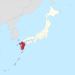 Kyushu region of Japan and the current prefectures on the island of Kyushu | |
| Geography | |
| Location | East Asia |
| Coordinates | 33°N 131°E |
| Archipelago | Japanese Archipelago |
| Area | 36,782.37[1] km2 (14,201.75 sq mi) |
| Area rank | 37th |
| Coastline | 12,221 km (7593.8 mi) |
| Highest elevation | 1,791 m (5876 ft) |
| Highest point | Mount Kujū[2] |
| Administration | |
| Prefectures | |
| Largest settlement | Fukuoka |
| Demographics | |
| Population | 12,650,847 (as of June 2022) |
| Pop. density | 307.13/km2 (795.46/sq mi) |
| Ethnic groups | Japanese, Ryukyuan |
| Additional information | |
| Time zone |
|
In the 8th-century Taihō Code reforms, Dazaifu was established as a special administrative term for the region.[6]
Geography


The island is mountainous, and Japan's most active volcano, Mount Aso at 1,591 metres (5,220 ft), is on Kyushu. There are many other signs of tectonic activity, including numerous areas of hot springs. The most famous of these are in Beppu, on the east shore, and around Mt. Aso in central Kyushu. The island is separated from Honshu by the Kanmon Straits. Being the nearest island to the Asian continent,[7] historically it is the gateway to Japan.[8]
The total area is 36,782.37 km2 (14,201.75 sq mi) which makes it the 37th largest island in the world.[1] It's slightly larger than Taiwan island 35,808 km2 (13,826 sq mi).[5] The highest elevation is 1791 meters (5876 feet) on Mount Kujū.[9]
The name Kyūshū comes from the nine ancient provinces of Saikaidō situated on the island: Chikuzen, Chikugo, Hizen, Higo, Buzen, Bungo, Hyūga, Osumi, and Satsuma.[10]
Today's Kyushu Region (九州地方, Kyūshū-chihō) is a politically defined region that consists of the seven prefectures on the island of Kyushu (which also includes the former Tsushima and Iki as part of Nagasaki), plus Okinawa Prefecture to the south:
- Northern Kyushu
- Southern Kyushu
- Okinawa
Population
Kyushu has 10.3 percent of the population of Japan.[11] Most of Kyushu's population is concentrated along the northwest, in the cities of Fukuoka and Kitakyushu, with population corridors stretching southwest into Sasebo and Nagasaki and south into Kumamoto and Kagoshima. Except for Oita and Miyazaki, the eastern seaboard shows a general decline in population.
Politically, Kyushu is described as a stronghold of the Liberal Democratic Party.[12]
Per Japanese census data,[13][14] the Kyushu region's population with Ryukyu Islands (Okinawa and Kagoshima Prefectures) has experienced a large population decline since around 2000. However, the population decline is mild mainly due to relatively high birth rate of Ryukyuans both within the Ryukyuan lands (Okinawa and Kagoshima) and throughout the Kyushu region. In addition, the other prefectures in Kyushu also have exceptionally high TFRs compared to the rest of Japan.[15][16] The Ryukyuans are an indigenous minority group in Japan.
Including Ryukyu Islands
|
Excluding Ryukyu Islands
| ||||||||||||||||||||||||||||||||||||||||||||||||||||||||||||||||||||||||||||||||||||
Designated cities
- Fukuoka (population: 1,588,924)
- Kitakyushu (population: 940,978)
- Kumamoto (population: 738,907)
Core cities
- Kagoshima
- Ōita
- Nagasaki
- Miyazaki
- Naha
- Kurume
- Sasebo
- Saga
Environment and agriculture


Parts of Kyushu have a subtropical climate, particularly Miyazaki prefecture and Kagoshima prefecture. Major agricultural products are rice, tea, tobacco, sweet potatoes, and soy; also, silk is widely produced.
Besides the volcanic area of the south, there are significant mud hot springs in the northern part of the island, around Beppu. The springs are the site of occurrence of certain extremophile microorganisms, which are capable of surviving in extremely hot environments.[17]
Economy
Kyushu is noted for various types of porcelain, including Arita, Imari, Satsuma, and Karatsu. Heavy industry is concentrated in the north around Fukuoka, Kitakyushu, Nagasaki, and Oita and includes chemicals, automobiles, semiconductors, metal processing, shipbuilding, etc.[18]
In 2010, the graduate employment rate in the region was the lowest nationwide, at 88.9%.[19]
Education
Major universities and colleges in Kyushu:
- National universities
- Kyushu University – One of seven former "Imperial Universities"
- Kyushu Institute of Technology
- Saga University
- Nagasaki University
- Kumamoto University
- Fukuoka University of Education
- Oita University
- Miyazaki University
- Kagoshima University
- National Institute of Fitness and Sports in Kanoya
- University of the Ryukyus
- Universities run by local governments
- University of Kitakyushu
- Kyushu Dental College
- Fukuoka Women's University
- Fukuoka Prefectural University
- Nagasaki Prefectural University
- Oita University of Nursing and Health Sciences
- Prefectural University of Kumamoto
- Miyazaki Municipal University
- Miyazaki Prefectural Nursing University
- Okinawa Prefectural University of Arts
- Major private universities
- Fukuoka University – University with the largest number of students in Kyushu
- Kumamoto Gakuen University
- Ritsumeikan Asia Pacific University
- Seinan Gakuin University
- Kyushu Sangyo University – Baseball team won the Japanese National Championship in 2005
- University of Occupational and Environmental Health
- Kurume University
Transportation
Kyushu is linked to the larger island of Honshu by the Kanmon Railway Tunnel,[20] which carries the non-Shinkansen trains of the Kyushu Railway Company, and the newer Shin-Kanmon Tunnel carrying the San'yō Shinkansen. Railways on the island are operated by the Kyushu Railway Company and West Japan Railway Company, as well as a variety of smaller companies such as Amagi Railway[21] and Nishitetsu Railway.[22] Kyushu Shinkansen trains also operate between major cities on the island,[23] such as Fukuoka and Kagoshima,[24] with an additional route under construction between Fukuoka and Nagasaki expected to be in operation from 2023.[25] Kyushu is also known for its scenic train services, such as the Limited Express Yufuin no Mori and Limited Express Kawasemi Yamasemi.[23]
The Kanmon Bridge and Kanmon Roadway Tunnel also connect the island with Honshu, allowing for vehicular transport between the two.[26] The Kyushu Expressway spans the length of the island, linking the Higashikyushu Expressway and Ibusuki Skyline, connecting major cities such as Fukuoka and Kumamoto along the way.[citation needed] There are also many quiet country roads, including popular tourist routes such as the Nichinan coast road and the Aso Panorama Line in Kumamoto Prefecture. Bus services are available and cover 2,400 routes within Kyushu's cities, connecting many other destinations.[23]
Several passenger and car ferry services connect both northern and southern Kyushu with main port cities on the main island of Honshu (Kobe, Osaka, Tokyo) and Shikoku.[27]
See also
- Azumi people, an ancient group of people who inhabited parts of Northern Kyūshū
- Geography of Japan
- Group Kyushu
- Hoenn, a fictional region in the Pokémon franchise which is based on Kyushu
- Japanese archipelago
- Kanmonkyo Bridge, that connects Kyūshū with Honshū
- Kyushu National Museum
- Kyushu dialects, Hichiku dialect, Hōnichi dialect, and Kagoshima dialect
- List of regions in Japan
- Northern Kyushu, Southern Kyushu
- United States Fleet Activities Sasebo
- Western Army (Japan)
References
- "平成28年全国都道府県市区町村別面積調 島面積" (PDF). 国土地理院. 2016-10-01. Retrieved 2017-02-27.
- "Kujū-san, Japan". Peakbagger.com.
- "離島とは(島の基礎知識) (what is a remote island?)". MLIT (Ministry of Land, Infrastructure, Transport and Tourism) (in Japanese). Ministry of Land, Infrastructure, Transport and Tourism. 22 August 2015. Archived from the original (website) on 2007-11-13. Retrieved 9 August 2019.
MILT classification 6,852 islands(main islands: 5 islands, remote islands: 6,847 islands)
- Nussbaum, Louis-Frédéric. (2005). "Kyūshū" in Japan Encyclopedia, p. 588, p. 588, at Google Books
- "Discover the Geography of the 4 Main Islands of Japan". ThoughtCo. Retrieved 2018-09-26.
- Nussbaum, "Dazaifu" in p. 150, p. 150, at Google Books; Dazaifu
- Nussbaum, Louis-Frédéric and Käthe Roth (2005). Japan Encyclopedia. Cambridge, Mass.: Harvard University Press. ISBN 978-0-674-01753-5. OCLC 58053128.
- Cobbing, Andrew (2009). Kyushu, gateway to Japan : a concise history. Global Oriental. p. 157. ISBN 9789004213128. OCLC 754792858.
- "Japan Ultra-Prominences". Peaklist.org. Retrieved 2015-01-01.
- Cobbing, Andrew (2009). Kyushu, Gateway to Japan: A Concise History. Global Oriental. p. 3. ISBN 9789004213128. OCLC 754792858.
- Boquet, Yves (2017). The Philippine Archipelago. Springer. p. 16. ISBN 9783319519265.
- "Japanese voters want a plan to handle a declining population". The Economist. 5 October 2017.
- "Fukuoka (Japan): Prefecture, Major Cities & Towns - Population Statistics, Maps, Charts, Weather and Web Information". www.citypopulation.de.
- "Japan Prefectures Population from 1920 and Area". www.demographia.com.
- 「都市と地方における子育て環境の違いから得られた知見」
- "令和2年(2020)人口動態統計月報年計(概数)の概況" (PDF).
- C. Michael Hogan. 2010. Extremophile. eds. E. Monosson and C. Cleveland. Encyclopedia of Earth. National Council for Science and the Environment, Washington DC
- "JAPAN PRODUCTS: Business Directory of Japanese Companies". Retrieved 2020-05-28.
- "Grads landing jobs near all-time low". The Japan Times. May 22, 2010. Retrieved 22 October 2010.
- "Kanmon Tunnel | Description, History, Construction, & Facts". Encyclopedia Britannica. Retrieved 2021-10-20.
- "Railways in Kyushu". www.sinfin.net. Retrieved 2021-10-20.
- "Railways in Northern Kyushu". www.japaneserailwaysociety.com. Retrieved 2021-10-20.
- "Getting Around | Kyushu Tourism Promotion Organization". www.visit-kyushu.com. Retrieved 2021-10-20.
- "Kyushu Shinkansen". Japan Visitor. Retrieved 2021-10-20.
{{cite web}}: CS1 maint: url-status (link) - "Fukuoka to Nagasaki: How to go from Fukuoka to Nagasaki? | Japan-Rail-Pass". Japan Rail Pass | Japan Rail Pass. 2020-07-10. Retrieved 2022-04-21.
- MATCHA. "Walk From Honshu To Kyushu! 4 Ways To Cross Between The Two Islands". MATCHA - JAPAN TRAVEL WEB MAGAZINE. Retrieved 2021-10-20.
- "Domestic Ferries".
External links
 The dictionary definition of Kyushu at Wiktionary
 Media related to Kyushu (category) at Wikimedia Commons
 Kyushu travel guide from Wikivoyage
Regions and administrative divisions of Japan | |||||||||||||||||
|---|---|---|---|---|---|---|---|---|---|---|---|---|---|---|---|---|---|
| |||||||||||||||||
| Regions |  | ||||||||||||||||
| 47 Prefectures |
| ||||||||||||||||
| |||||||||||||||||
| 100,000 km2 (39,000 sq mi) and greater |
| |
|---|---|---|
| 20,000–99,999 km2 (7,722–38,610 sq mi) |
| |
На других языках
[de] Kyūshū
Kyūshū (jap. 九州, anhören?/i, deutsch „neun Provinzen“) ist mit einer Fläche von 36.782,35 km²[1] und 13 Mio. Einwohnern die drittgrößte und zweitbevölkerungsreichste Hauptinsel Japans. (Stand 1. Dez. 2014)- [en] Kyushu
[es] Kyūshū
Kyūshū[1] (九州, Kyūshū?) es la tercera isla más grande de Japón, ubicada al sur del archipiélago. Es considerada la cuna de la civilización japonesa. La isla ha tenido distintos nombres a través de su historia, entre estos figuran: Kyukoku (九国), Chinzei (鎮西), y Tsukushi-shima (筑紫島). La antigua región de Saikaido comprendía Kyushu y las islas adyacentes.[fr] Kyūshū
Kyūshū (九州?) ou Kiou-Siou, /kʲɯꜜːɕɯ/ .mw-parser-output .prononciation>a{background:url("//upload.wikimedia.org/wikipedia/commons/thumb/8/8a/Loudspeaker.svg/11px-Loudspeaker.svg.png")center left no-repeat;padding-left:15px;font-size:smaller}Écouter, est la plus méridionale des quatre îles principales du Japon, la troisième par sa taille. Elle est considérée comme le lieu de naissance de la civilisation japonaise.[it] Kyūshū
Kyūshū (九州? letteralmente "nove province") è una delle otto regioni del Giappone, situata direttamente a sud-ovest dell'isola principale dell'arcipelago nipponico, Honshū, e, ad ovest, dell'isola di Shikoku. È la terza, in ordine di grandezza, tra le quattro maggiori isole che compongono l'arcipelago giapponese. Sulla costa sud-occidentale dell'isola è situata la città di Nagasaki, capitale dell'omonima prefettura. È considerato il luogo di nascita della civiltà giapponese.mw-parser-output .chiarimento{background:#ffeaea;color:#444444}.mw-parser-output .chiarimento-apice{color:red}[senza fonte]. Nell'antichità era anche conosciuto sotto il nome di Kyūkoku (九国?), Chinzei (鎮西?) e Tsukushi-no-shima (筑紫島?). L'isola, durante l'arcaico ordinamento amministrativo statale nipponico del Gokishichidō (五畿七道, Cinque Provincie e Sette Circuiti), costituiva assieme ai limitrofi micro-arcipelago di Tsushima ed isola di Iki (oggi tutte parti della prefettura di Nagasaki) uno dei sette circuiti (dō) del Paese, il Saikaidō (西海道, Circuito del Mare Occidentale)[2][3].[ru] Кюсю
Кю́сю[1][2] (яп. 九州 Кю:сю:, букв. «девять провинций»), также Кюсю́[3] — третий по величине остров Японского архипелага. Площадь: 35640 км². Население 12,0 млн чел. (2010); плотность населения — 295,6 чел./км². Протяжённость с севера на юг: 320 км. Максимальная ширина острова: 220 км.Другой контент может иметь иную лицензию. Перед использованием материалов сайта WikiSort.org внимательно изучите правила лицензирования конкретных элементов наполнения сайта.
WikiSort.org - проект по пересортировке и дополнению контента Википедии