geo.wikisort.org - Island
Bananal Island (Portuguese: Ilha do Bananal, IPA: [banaˈnaw]) is a large river island formed from the bisection of the Araguaia River, in southwestern Tocantins, Brazil. The island is formed by a fork in a very flat section of the Araguaia River. Bananal Island is the second largest river island in the world and the largest without an ocean coastline, at 350 kilometres (220 mi) long and 55 kilometres (34 mi) wide.[2] Its total area is 19,162.25 square kilometres (7,398.59 sq mi).[3] The rivers within the island flow parallel to the Araguaia, and the Jaburu do Bananal is the longest river within a river.
This article may be expanded with text translated from the corresponding article in Portuguese. (March 2021) Click [show] for important translation instructions.
|
Native name: Ilha do Bananal | |
|---|---|
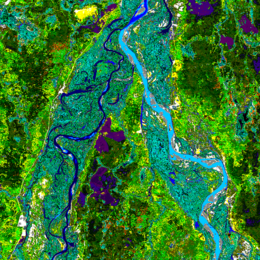 Landsat image of the northern end of Bananal Island (the Rio das Mortes-Cristalino peninsula) on the Araguaia River | |
 Bananal Location in Brazil | |
| Geography | |
| Location | Tocantins, Brazil |
| Coordinates | 11°20′S 50°41′W |
| Area | 19,162.25 km2 (7,398.59 sq mi) |
| Area rank | 49th |
| Administration | |
Brazil | |
| State | Tocantins |
Ramsar Wetland | |
| Official name | Ilha do Bananal |
| Designated | 4 October 1993 |
| Reference no. | 624[1] |
Environmental and cultural protection
Bananal Island is a nature and culture preserve. In accordance with Article 28 of the Statute of Indian Law (Artigo 28 do Estatuto do Indío-lei) No. 6001 laid out on 19 December 1973, an area of 5,577.26 square kilometres (2,153.39 sq mi) is preserved as Araguaia National Park and further 13,584.99 square kilometres (5,245.19 sq mi) as cultural preserve for indigenous peoples. The northern third of the island, which is designated as a national park, is a popular destination for ecotourism. The southern two-thirds are indigenous territories.
Inhabitants
Although Brazilians of non-native descent lived on the island in the past, today only indigenous people populate the island.
At least four tribes live on Bananal Island: the Javaés, Karajá, Ava-Canoeiro, and Tuxá. There are sixteen aldeias or villages on the island: Barra do Rio, Barreira Branca, Boa Esperança, Boto Velho, Cachoeirinha, Fontoura, JK, Kanoanã, Kaxiwe, Macaúba, Santa Isabel, São João, Txoude, Txuiri, Wari-Wari, Watau.
There are no bridges to the island from the states of Tocantins to the east nor from Mato Grosso to the west. For the greater majority of the year, the only transport to the island is by boat. However, for a few weeks during the dry season (June - August) the river is low enough that the island can be reached by car. The villages have roads wide enough for cars and tractors even though the main forms of transport are by horse, bicycle, and foot.
Image gallery
 Ceramic statuette - MHNT

Municipalities
From north to south, the island forms the western portions of the municipalities of Pium, Lagoa da Confusão, and Formoso do Araguaia, in southwestern Tocantins.
References
- "Ilha do Bananal". Ramsar Sites Information Service. Retrieved 25 April 2018.
- Island Superlatives
- "Bananal Island". Encyclopædia Britannica. Encyclopædia Britannica Inc. 2015. Retrieved 28 July 2015.
| 100,000 km2 (39,000 sq mi) and greater |
| |
|---|---|---|
| 20,000–99,999 km2 (7,722–38,610 sq mi) |
| |
Authority control | |
|---|---|
| General |
|
| National libraries | |
На других языках
[de] Ilha do Bananal
Die Ilha do Bananal (deutsch: Insel der Bananenplantage) ist eine Flussinsel zwischen dem Rio Araguaia und seinem östlichen Nebenstrom Rio Javaés im brasilianischen Bundesstaat Tocantins an der Grenze zum Bundesstaat Mato Grosso. Sie ist rund 350 Kilometer lang, bis 55 Kilometer breit und hat eine Fläche von 19.162 km².- [en] Bananal Island
[es] Isla del Bananal
La isla del Bananal o isla Bookash (en portugués, Ilha do Bananal o Bookash) es la mayor isla fluvial del mundo, con cerca de veinte mil km² de extensión.[fr] Île de Bananal
L'île de Bananal (Ilha do Bananal en portugais) se trouve au Brésil, dans l'État du Tocantins au milieu de deux très larges bras du rio Araguaia. Elle est la plus grande île fluviale au monde avec une superficie de 19 162 km2 (environ deux fois celle du Liban ou de la Jamaïque) mesurant 350 kilomètres de longueur pour 55 kilomètres de largeur. De janvier à mars, elle est partiellement recouverte par la crue hivernale du rio Araguaia.[it] Isola Bananal
L'isola Bananal (in portoghese Ilha do Bananal) è un'isola fluviale, situata nello Stato brasiliano di Tocantins e formata dalla biforcazione del fiume Araguaia nei fiumi Araguaia e Javaés in una piana molto bassa. Vasta 19.162,25 km², con una lunghezza di 350 km ed una larghezza di 55 km, si tratta dell'isola fluviale più grande del mondo.[ru] Бананал (остров)
Банана́л (порт. Ilha do Bananal) — речной остров, расположенный в среднем течении реки Арагуая.Другой контент может иметь иную лицензию. Перед использованием материалов сайта WikiSort.org внимательно изучите правила лицензирования конкретных элементов наполнения сайта.
WikiSort.org - проект по пересортировке и дополнению контента Википедии