geo.wikisort.org - Island
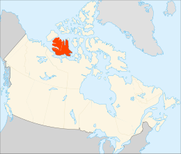
Victoria Island (Inuinnaqtun: Kitlineq)[6][7] is a large island in the Arctic Archipelago that straddles the boundary between Nunavut and the Northwest Territories of Canada. It is the eighth-largest island in the world, and at 217,291 km2 (83,897 sq mi)1 in area, it is Canada's second-largest island. It is nearly double the size of Newfoundland (111,390 km2 [43,010 sq mi]), and is slightly larger than the island of Great Britain (209,331 km2 [80,823 sq mi]) but smaller than Honshu (225,800 km2 [87,200 sq mi]). The western third of the island lies in the Inuvik Region of the Northwest Territories; the remainder is part of Nunavut's Kitikmeot Region.
Native name: Kitlineq | |
|---|---|
 | |
 | |
| Geography | |
| Location | Northern Canada |
| Coordinates | 70°25′N 107°45′W[1] |
| Archipelago | Arctic Archipelago |
| Area | 217,291 km2 (83,897 sq mi)[3] |
| Area rank | 8th |
| Length | 700 km (430 mi) |
| Width | 564–623 km (350–387 mi) |
| Highest elevation | 655 m (2149 ft) |
| Highest point | Unnamed |
| Administration | |
Canada | |
| Territories | Northwest Territories Nunavut |
| Largest settlement | Cambridge Bay, Nunavut (pop. 1,760[4]) |
| Demographics | |
| Population | 2,168[4][5] (2021) |
| Ethnic groups | Inuit |
The island is named after Queen Victoria, the Canadian sovereign from 1867 to 1901 (though she first became Queen in 1837). The features bearing the name "Prince Albert" are named after her consort, Albert.
History

In 1826 John Richardson saw the southwest coast and called it "Wollaston Land".[8] In 1839 Peter Warren Dease and Thomas Simpson followed its southeast coast and called it "Victoria Land".[9] A map published by John Barrow in 1846 shows a complete blank from these two lands north to "Banks Land" which is the north coast of Banks Island.[10] In 1851 John Rae charted its entire south coast and connected the two "lands".[11] In 1850 and 1851 Robert McClure circumnavigated most of Banks Island, thereby separating it from the rest of Victoria Land. His men also charted the northwest and west coasts of Victoria Island.[12] One of Roald Amundsen's men, Godfred Hansen, charted its east coast as far as Cape Nansen in 1905,[13] and in 1916 and 1917 Storker T. Storkerson, of Vilhjalmur Stefansson's Canadian Arctic Expedition, charted its northeast coast, sighting the Storkerson Peninsula.[14]
In 2008 Clark Carter and Chris Bray became the first recorded people to walk across Victoria Island. Their first attempt at the 1,000 km (620 mi) trek in 2005 failed, so they returned and completed the remaining 660 km (410 mi) in 2008.[15][16]
Geography
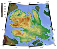

Viscount Melville Soundmap1 lies to the north, and the M'Clintock Channelmap2 and Victoria Straitmap3 lie eastward. On the west are Amundsen Gulfmap4 and Banks Island,map5 which is separated from Victoria by a long sound called the Prince of Wales Strait.map6 To the south (from west to east) lie the Dolphin and Union Strait,map7 Austin Bay,map8 Coronation Gulfmap9 and the Dease Strait.map10
The southern waterways, and sometimes the Prince of Wales Strait, form part of the disputed Northwest Passage which the Government of Canada claims are Canadian Internal Waters, while other nations state they are either territorial waters or international waters.[17]
Victoria Island is an island of peninsulas, having a heavily indented coastline with many inlets. In the east, pointing northwards, is the Storkerson Peninsula,map11 which ends with the Goldsmith Channel,map12 the body of water separating Victoria from Stefansson Island.map13 The Storkerson Peninsula is separated from the island's north-central areas by Hadley Bay,map14 a major inlet. Another, broad peninsula is found in the north, Prince Albert Peninsula.map15 This ends at the Prince of Wales Strait. In the south, and pointing westwards, is the Wollaston Peninsula,map16 separated from the island's central areas by Prince Albert Sound.
The highest point of Victoria Island is 655 m (2,149 ft) in the Shaler Mountainsmap17 in the north-central region. Located in the southeast, just north of Cambridge Bay, is Tahiryuaq (formerly Ferguson Lake)map18. With an area of 562 km2 (217 sq mi), it is the largest lake on the island.[18]
It was said by Andrew Hund in his book, Antarctica and the Arctic Circle: A Geographic Encyclopedia of the Earth's Polar Regions, that the island resembles a stylized maple leaf, the predominant symbol of Canada.[19]
Climate
Victoria Island has a polar climate, with no month having an average temperature of 10 °C (50 °F) or higher, and is listed as ET on the Köppen climate classification. Summers are typically cool and rainy, with pleasant days and chilly nights. Winters are cold, dark, and long, with October being the snowiest month. Snowfall and frosts are possible all year round. Rainfall is usually limited to the summer months, when the temperature shortly rises above freezing for a few months before dipping back down for another 9 months of winter. Springs are typically sunny but still very chilly. Autumns are short and crisp, with more frequent cloud cover starting to appear during August and with September being almost constantly cloudy.
At Cambridge Bay, the sun is continuously below the horizon, polar night, from approximately 30 November to 11 January and above the horizon, midnight sun, 19 May to 22 July.[20]
| Climate data for Cambridge Bay (Cambridge Bay Airport) WMO ID: 71925; coordinates 69°06′29″N 105°08′18″W; elevation: 31.1 m (102 ft); 1981–2010 normals | |||||||||||||
|---|---|---|---|---|---|---|---|---|---|---|---|---|---|
| Month | Jan | Feb | Mar | Apr | May | Jun | Jul | Aug | Sep | Oct | Nov | Dec | Year |
| Record high humidex | −5.0 | −9.7 | −4.1 | 3.9 | 10.5 | 25.3 | 30.8 | 28.6 | 16.3 | 5.8 | −1.4 | −3.5 | 30.8 |
| Record high °C (°F) | −4.9 (23.2) |
−9.4 (15.1) |
−4.0 (24.8) |
6.1 (43.0) |
11.5 (52.7) |
23.3 (73.9) |
28.9 (84.0) |
26.1 (79.0) |
16.4 (61.5) |
6.9 (44.4) |
0.0 (32.0) |
−3.4 (25.9) |
28.9 (84.0) |
| Average high °C (°F) | −28.5 (−19.3) |
−28.9 (−20.0) |
−25.3 (−13.5) |
−16.3 (2.7) |
−5.6 (21.9) |
5.8 (42.4) |
12.8 (55.0) |
9.8 (49.6) |
2.5 (36.5) |
−7.3 (18.9) |
−18.8 (−1.8) |
−24.9 (−12.8) |
−10.4 (13.3) |
| Daily mean °C (°F) | −32.0 (−25.6) |
−32.5 (−26.5) |
−29.3 (−20.7) |
−20.8 (−5.4) |
−9.3 (15.3) |
2.7 (36.9) |
8.9 (48.0) |
6.8 (44.2) |
0.3 (32.5) |
−10.4 (13.3) |
−22.3 (−8.1) |
−28.3 (−18.9) |
−13.9 (7.0) |
| Average low °C (°F) | −35.4 (−31.7) |
−36.1 (−33.0) |
−33.2 (−27.8) |
−25.3 (−13.5) |
−13.0 (8.6) |
−0.3 (31.5) |
4.9 (40.8) |
3.8 (38.8) |
−1.9 (28.6) |
−13.5 (7.7) |
−25.7 (−14.3) |
−31.8 (−25.2) |
−17.3 (0.9) |
| Record low °C (°F) | −52.8 (−63.0) |
−50.6 (−59.1) |
−48.3 (−54.9) |
−42.8 (−45.0) |
−35.0 (−31.0) |
−17.8 (0.0) |
−1.7 (28.9) |
−8.9 (16.0) |
−17.2 (1.0) |
−33.0 (−27.4) |
−43.9 (−47.0) |
−49.4 (−56.9) |
−52.8 (−63.0) |
| Record low wind chill | −73.4 | −72.6 | −69.8 | −60.1 | −43.2 | −29.2 | −7.9 | −13.1 | −28.6 | −49.4 | −60.7 | −66.3 | −73.4 |
| Average precipitation mm (inches) | 5.8 (0.23) |
4.9 (0.19) |
7.1 (0.28) |
5.7 (0.22) |
7.0 (0.28) |
13.6 (0.54) |
24.1 (0.95) |
25.7 (1.01) |
19.1 (0.75) |
14.7 (0.58) |
8.0 (0.31) |
6.1 (0.24) |
141.7 (5.58) |
| Average rainfall mm (inches) | 0.0 (0.0) |
0.0 (0.0) |
0.0 (0.0) |
0.0 (0.0) |
1.0 (0.04) |
10.0 (0.39) |
23.9 (0.94) |
23.9 (0.94) |
12.7 (0.50) |
0.6 (0.02) |
0.0 (0.0) |
0.0 (0.0) |
72.1 (2.84) |
| Average snowfall cm (inches) | 6.7 (2.6) |
5.9 (2.3) |
8.4 (3.3) |
6.9 (2.7) |
7.2 (2.8) |
3.8 (1.5) |
0.1 (0.0) |
1.8 (0.7) |
6.8 (2.7) |
15.9 (6.3) |
9.8 (3.9) |
6.8 (2.7) |
80.2 (31.6) |
| Average precipitation days (≥ 0.2 mm) | 7.3 | 6.8 | 9.2 | 6.8 | 7.1 | 8.0 | 10.7 | 13.1 | 11.9 | 12.1 | 9.0 | 7.9 | 109.8 |
| Average rainy days (≥ 0.2 mm) | 0.0 | 0.0 | 0.0 | 0.0 | 0.9 | 5.9 | 10.7 | 12.5 | 7.1 | 0.6 | 0.0 | 0.0 | 37.8 |
| Average snowy days (≥ 0.2 cm) | 7.4 | 6.9 | 9.8 | 7.1 | 7.3 | 3.4 | 0.1 | 1.2 | 6.3 | 12.5 | 9.5 | 8.3 | 79.8 |
| Average relative humidity (%) | 65.3 | 66.4 | 70.5 | 76.2 | 83.8 | 77.2 | 68.2 | 73.6 | 82.3 | 86.2 | 76.5 | 70.0 | 74.7 |
| Mean monthly sunshine hours | 7.3 | 73.7 | 169.6 | 275.9 | 245.1 | 291.6 | 333.8 | 186.6 | 71.7 | 56.8 | 17.6 | 0.0 | 1,729.7 |
| Percent possible sunshine | 11.7 | 35.4 | 47.1 | 57.7 | 36.6 | 40.5 | 45.9 | 33.6 | 17.8 | 20.0 | 13.5 | 0.0 | 30.0 |
| Source: Environment and Climate Change Canada Canadian Climate Normals 1981–2010[21] | |||||||||||||
| Climate data for Ulukhaktok (Ulukhaktok/Holman Airport) Climate ID: 2502501; coordinates 70°45′46″N 117°48′22″W; elevation: 36.0 m (118.1 ft); 1981–2010 normals | |||||||||||||
|---|---|---|---|---|---|---|---|---|---|---|---|---|---|
| Month | Jan | Feb | Mar | Apr | May | Jun | Jul | Aug | Sep | Oct | Nov | Dec | Year |
| Record high humidex | −7.2 | −9.4 | −7.6 | 6.9 | 10.6 | 23.0 | 27.9 | 24.5 | 17.1 | 5.1 | 0.1 | −3.2 | 27.9 |
| Record high °C (°F) | −4.0 (24.8) |
−6.5 (20.3) |
−5.0 (23.0) |
4.5 (40.1) |
11.5 (52.7) |
22.5 (72.5) |
29.0 (84.2) |
23.5 (74.3) |
15.8 (60.4) |
5.9 (42.6) |
1.1 (34.0) |
−3.0 (26.6) |
29.0 (84.2) |
| Average high °C (°F) | −24.3 (−11.7) |
−24.9 (−12.8) |
−21.4 (−6.5) |
−12.6 (9.3) |
−3.2 (26.2) |
7.8 (46.0) |
12.8 (55.0) |
9.3 (48.7) |
3.1 (37.6) |
−6.2 (20.8) |
−16.5 (2.3) |
−21.6 (−6.9) |
−8.1 (17.4) |
| Daily mean °C (°F) | −28.0 (−18.4) |
−28.8 (−19.8) |
−25.6 (−14.1) |
−17.0 (1.4) |
−6.6 (20.1) |
4.6 (40.3) |
9.0 (48.2) |
6.4 (43.5) |
0.9 (33.6) |
−8.9 (16.0) |
−19.8 (−3.6) |
−25.2 (−13.4) |
−11.6 (11.1) |
| Average low °C (°F) | −31.8 (−25.2) |
−32.6 (−26.7) |
−29.8 (−21.6) |
−21.4 (−6.5) |
−10.0 (14.0) |
1.4 (34.5) |
5.2 (41.4) |
3.4 (38.1) |
−1.3 (29.7) |
−11.4 (11.5) |
−23.1 (−9.6) |
−28.6 (−19.5) |
−15.0 (5.0) |
| Record low °C (°F) | −47.5 (−53.5) |
−49.0 (−56.2) |
−45.0 (−49.0) |
−42.1 (−43.8) |
−26.5 (−15.7) |
−12.5 (9.5) |
−3.5 (25.7) |
−5.5 (22.1) |
−15.5 (4.1) |
−36.8 (−34.2) |
−37.5 (−35.5) |
−42.8 (−45.0) |
−49.0 (−56.2) |
| Record low wind chill | −59.8 | −59.2 | −61.9 | −45.6 | −31.0 | −18.3 | −6.8 | −11.1 | −21.9 | −44.7 | −51.3 | −51.2 | −61.9 |
| Average precipitation mm (inches) | 8.4 (0.33) |
7.5 (0.30) |
7.3 (0.29) |
5.3 (0.21) |
7.4 (0.29) |
8.0 (0.31) |
22.4 (0.88) |
32.2 (1.27) |
19.8 (0.78) |
17.1 (0.67) |
11.5 (0.45) |
8.5 (0.33) |
155.3 (6.11) |
| Average rainfall mm (inches) | 0.0 (0.0) |
0.0 (0.0) |
0.0 (0.0) |
0.0 (0.0) |
1.1 (0.04) |
6.9 (0.27) |
22.2 (0.87) |
30.2 (1.19) |
13.2 (0.52) |
0.6 (0.02) |
0.0 (0.0) |
0.0 (0.0) |
74.2 (2.92) |
| Average snowfall cm (inches) | 8.5 (3.3) |
7.5 (3.0) |
7.5 (3.0) |
5.3 (2.1) |
6.4 (2.5) |
1.2 (0.5) |
0.2 (0.1) |
2.0 (0.8) |
6.6 (2.6) |
16.9 (6.7) |
12.3 (4.8) |
8.9 (3.5) |
83.3 (32.8) |
| Average precipitation days (≥ 0.2 mm) | 5.3 | 5.2 | 4.9 | 3.9 | 4.8 | 4.7 | 7.8 | 11.0 | 9.3 | 9.5 | 7.3 | 5.3 | 78.9 |
| Average rainy days (≥ 0.2 mm) | 0.0 | 0.0 | 0.0 | 0.0 | 0.6 | 3.9 | 7.8 | 10.5 | 6.3 | 0.4 | 0.0 | 0.0 | 29.4 |
| Average snowy days (≥ 0.2 cm) | 5.3 | 5.2 | 5.0 | 3.9 | 4.4 | 1.0 | 0.2 | 0.8 | 3.5 | 9.4 | 7.4 | 5.4 | 51.5 |
| Source: Environment and Climate Change Canada[22] | |||||||||||||
Biology
The Dolphin-Union caribou herd locally known as Island Caribou[23][24] are a migratory population of barren-ground caribou, Rangifer tarandus groenlandicus, that occupy Victoria Island in Canada's High Arctic and the nearby mainland. They are endemic to Canada. They migrate across the Dolphin and Union Strait from their summer grazing on Victoria Island to their winter grazing area on the Nunavut-NWT mainland.[23][25] It is unusual for North American caribou to seasonally cross sea ice and the only other caribou to do so are the Peary caribou, which are smaller in size and population, and also occur on Victoria Island.[26]
Victoria Island contains the world's largest island within an island within an island.[27]
Demographics
In the 2021 Canadian census the population of the island was 2,168; 1,760[4] in Nunavut and 408[5] in the Northwest Territories. Of the two settlements on the island the larger is Cambridge Bay,map19 which lies on the south-east coast and is in Nunavut. Ulukhaktokmap20 is on the west coast and is in the Northwest Territories. Trading posts, such as Fort Collinsonmap21 on the northwest coast, have long been abandoned.[28]
List of places by population
| Name | Population |
|---|---|
| Cambridge Bay | 1,760[4] |
| Ulukhaktok | 408[5] |
Notes
- ^1 The United Nations Environment Programme says that Victoria Island has an area of 220,548 km2 (85,154 sq mi).[29] However, the Atlas of Canada indicates the island is 217,291 km2 (83,897 sq mi).[3]
Maps
- ^map1 Viscount Melville Sound - 74°15′N 105°00′W[30]
- ^map2 M'Clintock Channel - 72°00′N 102°00′W[31]
- ^map3 Victoria Strait - 69°31′N 100°30′W[32]
- ^map4 Amundsen Gulf - 71°00′01″N 124°00′10″W[33]
- ^map5 Banks Island - 72°45′02″N 121°30′10″W[34]
- ^map6 Prince of Wales Strait - 72°21′14″N 118°46′57″W[35]
- ^map7 Dolphin and Union Strait - 69°05′10″N 116°02′30″W[36]
- ^map8 Austin Bay - 68°33′N 113°10′W[37]
- ^map9 Coronation Gulf - 68°08′N 112°00′W[38]
- ^map10 Dease Strait - 68°50′N 107°30′W[39]
- ^map11 Storkerson Peninsula - 72°30′N 106°30′W[40]
- ^map12 Goldsmith Channel - 73°10′N 106°05′W[41]
- ^map13 Stefansson Island - 73°20′N 105°45′W[42]
- ^map14 Hadley Bay - 72°31′N 108°12′W[43]
- ^map15 Prince Albert Peninsula - 72°30′02″N 117°00′09″W[44]
- ^map16 Wollaston Peninsula - 69°41′05″N 115°10′30″W[45]
- ^map17 Shaler Mountains - 71°55′02″N 111°30′07″W[46]
- ^map18 Tahiryuaq - 69°25′16″N 105°16′03″W[47]
- ^map19 Cambridge Bay - 69°06′50″N 105°03′10″W[48]
- ^map20 Ulukhaktok - 70°44′12″N 117°46′19″W[49]
- ^map21 Fort Collinson - 71°37′02″N 117°52′09″W[50]
See also
- Parker's Notch
- Tunnunik impact crater
References
- "Victoria Island (Canada)". Geographical Names Data Base. Natural Resources Canada.
- "Victoria Island (Canada)". Geographical Names Data Base. Natural Resources Canada.
- "Atlas of Canada". Atlas.nrcan.gc.ca. 2009-08-12. Archived from the original on 2013-01-22. Retrieved 2010-08-30.
- "Population and dwelling counts: Canada, provinces and territories, and census subdivisions (municipalities), Nunavut". Statistics Canada. February 9, 2022. Retrieved February 19, 2022.
- "Population and dwelling counts: Canada, provinces and territories, and census subdivisions (municipalities), Northwest Territories". Statistics Canada. February 9, 2022. Retrieved February 18, 2022.
- "Society-COPPER-ESKIMO". ukc.ac.uk. Archived from the original on 2008-05-14. Retrieved 2008-11-01.
- Swann, Brian (2005). Wearing the Morning Star: Native American Song-Poems. Lincoln, Nebraska: University of Nebraska Press. p. 133. ISBN 0-8032-9340-2.
- Franklin, John (1828). Narrative of a second expedition to the shores of the Polar sea in the years 1825, 1826 and 1827, by John Franklin,... including an account of the progress of a detachment to the Eastward, by John Richardson. London: J. Murray.
John Franklin 1826.
- Simpson, Thomas (1843). Narrative of the discoveries on the north coast of America: effected by the officers of the Hudson's Bay Company during the years 1836-39. London: R. Bentley.
Thomas Simpson 1843.
- Derek Hayes,"Historical Atlas of the Arctic", map 136
- McGoogan, Kenneth (2003). Fatal passage: the true story of John Rae, the Arctic hero time forgot. New York: Carroll & Graf Publishers.
- McClure, Robert (1856). Osborn, Sherard (ed.). The Discovery of the North-West Passage. London: Longman, Brown, Green, Longmans, & Roberts.
- Amundsen, Roald and Godfred Hansen (1908). Roald Amundsen's "The North West Passage"; being the record of a voyage of exploration of the ship "Gjøa" 1903-1907. London: A Constable and Co. ISBN 9781548724412.
- Stefansson, Vilhjalmur (1922). The Friendly Arctic: The Story of Five Years in Polar Regions. New York: Macmillan.
- "Clark Carter's Arctic Circle Adventures to appear on the big screen". if.com. IF. Retrieved 22 August 2019.
- Aussie adventurers to try again with Victoria Island trek
- Beeler, Carolyn (4 September 2017). "Who controls the Northwest Passage? It's up for debate". PRI. Retrieved 1 October 2018.
- Ferguson Lake at the Atlas of Canada
- Hund, Andrew (2014). Antarctica and the Arctic Circle: A Geographic Encyclopedia of the Earth's Polar Regions. Santa Barbara, CA: ABC-CLIO. p. 725. ISBN 9781610693936.
- Sunrise/Sunset/Sun Angle Calculator Archived 6 November 2008 at the Wayback Machine at the National Research Council (Canada)
- "Cambridge Bay A *". Canadian Climate Normals 1981–2010. Environment and Climate Change Canada. Climate ID: 2400600. Retrieved 2014-04-30.
- "Ulukhaktok A". Canadian Climate Normals 1981-2010 Station Data. Environment and Climate Change Canada. Climate ID: 2502501. Retrieved 22 March 2021.
- GNWT, Species at Risk in the Northwest Territories 2012 (PDF), Government of Northwest Territories, Department of Environment and Natural Resources, ISBN 978-0-7708-0196-0, archived from the original (PDF) on 24 September 2015, retrieved 31 October 2014
- "COSEWIC Assessment and Update Status Report on the Peary Caribou Rangifer tarandus pearyi and Barren-ground Caribou Rangifer tarandus groenlandicus Dolphin and Union population in Canada" (PDF), COSEWIC, May 2004, ISBN 0-662-37375-8, retrieved 1 November 2014
- Poole, Kim G.; Patterson, Brent R.; Dumond, Mathieu (December 2010), "Sea Ice and Migration of the Dolphin and Union Caribou Herd in the Canadian Arctic: An Uncertain Future" (PDF), Arctic, 63 (4): 414–428, doi:10.14430/arctic3331, retrieved 31 October 2014
- NWT Species at Risk Peary Caribou
- Wolchover, Natalie (January 24, 2012). "World's Largest Island-in-a-lake-on-an-island-in-a-lake-on-an-island Seen on Google Earth". LiveScience. Retrieved September 15, 2013.
- Hudson's Bay Company. Fort Collinson
- Victoria Island at the UNEP
- "Viscount Melville Sound". Geographical Names Data Base. Natural Resources Canada.
- "M'Clintock Channel". Geographical Names Data Base. Natural Resources Canada.
- "Victoria Strait". Geographical Names Data Base. Natural Resources Canada.
- "Amundsen Gulf". Geographical Names Data Base. Natural Resources Canada.
- "Banks Island". Geographical Names Data Base. Natural Resources Canada.
- "Prince of Wales Strait". Geographical Names Data Base. Natural Resources Canada.
- "Dolphin and Union Strait". Geographical Names Data Base. Natural Resources Canada.
- "Austin Bay". Geographical Names Data Base. Natural Resources Canada.
- "Coronation Gulf". Geographical Names Data Base. Natural Resources Canada.
- "Dease Strait". Geographical Names Data Base. Natural Resources Canada.
- "Storkerson Peninsula". Geographical Names Data Base. Natural Resources Canada.
- "Goldsmith Channel". Geographical Names Data Base. Natural Resources Canada.
- "Stefansson Island". Geographical Names Data Base. Natural Resources Canada.
- "Hadley Bay". Geographical Names Data Base. Natural Resources Canada.
- "Prince Albert Peninsula". Geographical Names Data Base. Natural Resources Canada.
- "Wollaston Peninsula". Geographical Names Data Base. Natural Resources Canada.
- "Shaler Mountains". Geographical Names Data Base. Natural Resources Canada.
- "Tahiryuaq". Geographical Names Data Base. Natural Resources Canada.
- "Cambridge Bay". Geographical Names Data Base. Natural Resources Canada.
- "Ulukhaktok". Geographical Names Data Base. Natural Resources Canada.
- "Fort Collinson". Geographical Names Data Base. Natural Resources Canada.
Further reading
- Geological Survey of Canada, J. G. Fyles, D. A. Hodgson, and J. Bednarski. Quaternary Geology of Wynniatt Bay, Victoria Island, Northwest Territories. Open file (Geological Survey of Canada), 2718. 1988.
- Geological Survey of Canada, R. H. Rainbird, A. N. LeCheminant, and I. Lawyer. Geology, Duke of York Inlier, Victoria Island, Northwest Territories. Open file (Geological Survey of Canada), 3304. 1997.
- Geological Survey of Canada, D. A. Hodgson, and J. Bednarski. Preliminary Suficial Materials of Kagloryuak River (77F) and Burns Lake (77G), Victoria Island, Northwest Territories. Open file (Geological Survey of Canada), 2883. 1994.
- Gyselman, E. C., and L. K. Gould. Data on Amphidromous and Freshwater Fish from Central Victoria Island and Freshwater Systems Draining into Melville Sound and Elu Inlet, N.W.T., Canada. Winnipeg: Dept. of Fisheries and Oceans, 1992.
- Jakimchuk, R. D., and D. R. Carruthers. Caribou and Muskoxen on Victoria Island, N.W.T. Sidney, B.C.: R.D. Jakimchuk Management Associates Ltd, 1980.
- McGhee, Robert. An Archaeological Survey of Western Victoria Island, N.W.T., Canada. Ottawa, Ont: National Museums of Canada, 1971.
- Parmelee, David Freeland, H. A. Stephens, and Richard H. Schmidt. The Birds of Southeastern Victoria Island and Adjacent Small Islands. Ottawa: [Queen's Printer], 1967.
- Peterson, E. B., R. D. Kabzems, and V. M. Levson. Terrain and Vegetation Along the Victoria Island Portion of a Polar Gas Combined Pipeline System. Sidney, B.C.: Western Ecological Services, 1981.
- Rainbird, Robert H. Stratigraphy, Sedimentology and Tectonic Setting of the Upper Shaler Group, Victoria Island, Northwest Territories. Ottawa: National Library of Canada = Bibliothèque nationale du Canada, 1991. ISBN 0-315-66301-4
- Washburn, A. L. Reconnaissance Geology of Portions of Victoria Island and Adjacent Regions, Arctic Canada. [New York]: Geological Society of America, 1947.
External links
| 100,000 km2 (39,000 sq mi) and greater |
| |
|---|---|---|
| 20,000–99,999 km2 (7,722–38,610 sq mi) |
| |
Authority control | |
|---|---|
| General |
|
| National libraries | |
На других языках
[de] Victoria-Insel
Die Victoria-Insel (englisch Victoria Island, Inuktitut Kiilliniq[1]) ist die zweitgrößte Insel Kanadas und die achtgrößte Insel der Welt (nach anderen Zählungen die neunt- oder zehntgrößte). Sie liegt im Nordpolarmeer im Kanadisch-Arktischen Archipel und hat eine Größe von 217.291 km².[2] Der westliche Teil der Insel gehört politisch zur Inuvik Region der Nordwest-Territorien, der östliche Teil, und somit etwa zwei Drittel der Fläche, zur Region Kitikmeot des Territoriums Nunavut.- [en] Victoria Island
[es] Isla Victoria (Canadá)
La isla Victoria (Inuinnaqtun: Kitlineq) [1][2] es una gran isla en el archipiélago ártico canadiense que se extiende a ambos lados del límite entre Nunavut y los Territorios del Noroeste de Canadá. Es la octava isla más grande del mundo, y con 217.291 km² de superficie, es la segunda isla más grande de Canadá. Tiene casi el doble del tamaño de Terranova (111.390 km²) y es un poco más grande que la isla de Gran Bretaña (209.331 km²) pero más pequeña que Honshu (225,800 km²). El tercio occidental de la isla se encuentra en la región de Inuvik de los Territorios del Noroeste; el resto forma parte de la región de Kitikmeot de Nunavut.[fr] Île Victoria
L’île Victoria (en anglais : Victoria Island) est une île du Canada située dans le passage du Nord-Ouest, au-delà du cercle polaire arctique, à cheval entre le Nunavut et les Territoires du Nord-Ouest (tiers ouest de l'île). Avec 217 291 kilomètres carrés[1], est la deuxième plus grande île du Canada et la neuvième du monde, juste avant la Grande-Bretagne.[it] Isola Victoria (Canada)
L'isola Victoria è una delle isole artiche canadesi. Con i suoi 217.291 km² è l'ottava isola maggiore del mondo e la seconda del Canada: è circa il doppio della grandezza di Terranova. La terza parte a ovest dell'isola appartiene ai Territori del Nord-Ovest, Regione di Inuvik, mentre la parte restante è della Regione di Kitikmeot, nel territorio di Nunavut. A est dell'isola c'è lo stretto di Victoria; i Territori del Nord-Ovest continuano sulla terraferma verso sud, attraverso lo stretto di Pease. Ad ovest dell'isola si trovano il golfo di Amundsen e l'isola di Banks, che è separata da Victoria da un canale chiamato stretto del Principe di Galles.[ru] Виктория (остров, Канада)
Викто́рия[1] (англ. Victoria Island) — остров в составе Канадского Арктического архипелага. Второй по площади остров Канады и девятый в мире. Административно разделён между территорией Нунавут и Северо-Западными территориями.Другой контент может иметь иную лицензию. Перед использованием материалов сайта WikiSort.org внимательно изучите правила лицензирования конкретных элементов наполнения сайта.
WikiSort.org - проект по пересортировке и дополнению контента Википедии