geo.wikisort.org - Island
Tasmania (/tæzˈmeɪniə/; Palawa kani: lutruwita[14]) is an island state of Australia.[15] It is located 240 kilometres (150 miles) to the south of the Australian mainland, separated from it by the Bass Strait. The archipelago contains the southernmost point of the Australian federation. The state encompasses the main island of Tasmania, the 26th-largest island in the world, and the surrounding 1000 islands.[16] It is Australia's least populated state, with 569,825 residents as of December 2021[update]. The state capital and largest city is Hobart, with around 40 percent of the population living in the Greater Hobart area.[17]
Tasmania | ||||
|---|---|---|---|---|
State | ||||
 Flag  Coat of arms | ||||
Nickname(s):
| ||||
| Motto: Ubertas et Fidelitas (Latin) (English: Fertility and Faithfulness) | ||||
 Location of Tasmania in Australia Coordinates: 42°S 147°E | ||||
| Country | Australia | |||
| Before federation | Colony of Tasmania | |||
| Federation | 1 January 1901 | |||
| Named for | Abel Tasman | |||
| Capital and largest city | Hobart 42°52′50″S 147°19′30″E | |||
| Administration | 29 local government areas | |||
| Demonym(s) | ||||
| Government | ||||
• Monarch | Charles III | |||
• Governor | Barbara Baker | |||
• Premier | Jeremy Rockliff (Liberal) | |||
| Legislature | Parliament of Tasmania | |||
• Upper house | Legislative Council | |||
• Lower house | House of Assembly | |||
| Judiciary | Supreme Court of Tasmania | |||
| Parliament of Australia | ||||
• Senate | 12 senators (of 76) | |||
• House of Representatives | 5 seats (of 151) | |||
| Area | ||||
• Total | 90,758 km2 (35,042 sq mi) (7th) | |||
• Land | 68,401 km2 (26,410 sq mi) | |||
• Water | 22,357 km2 (8,632 sq mi) | |||
| Highest elevation | 1,617 m (5,305 ft) | |||
| Population | ||||
• December 2021 estimate | ||||
• Density | 8.3/km2 (21.5/sq mi) (4th) | |||
| GSP | 2020 estimate | |||
• Total | ||||
• Per capita | ||||
| Gini (2016) | 44.8[6] medium · 3rd | |||
| HDI (2019) | very high · 8th | |||
| Time zone | UTC+10:00 (AEST) | |||
• Summer (DST) | UTC+11:00 (AEDT) | |||
| Postal abbreviation | TAS | |||
| ISO 3166 code | AU-TAS | |||
| Symbols | ||||
| Mammal | Tasmanian devil (Sarcophilus harrisii)[8] | |||
| Bird | Yellow wattlebird (unofficial) (Anthochaera paradoxa)[9] | |||
| Flower | Tasmanian blue gum (Eucalyptus globulus)[10] | |||
| Plant | Leatherwood (unofficial) (Eucryphia lucida)[11] | |||
| Mineral | Crocoite (PbCrO4)[12] | |||
| Colour | Bottle Green (PMS 342), Yellow (PMS 114), & Maroon (PMS 194)[13] | |||
| Website | tas | |||
Tasmania's main island was inhabited by Aboriginal peoples for up to 40,000 years before British colonization.[18] It is thought that Aboriginal Tasmanians became separated from the mainland Aboriginal groups about 11,700 years ago, after rising sea levels formed Bass Strait.[19] The island was permanently settled by Europeans in 1803 as a penal settlement of the British Empire to prevent claims to the land by the First French Empire during the Napoleonic Wars.[20] The Aboriginal population is estimated to have been between 3,000 and 7,000 at the time of British settlement, but was almost wiped out within 30 years during a period of conflicts with settlers known as the "Black War" and the spread of infectious diseases. The conflict, which peaked between 1825 and 1831 and led to more than three years of martial law, cost the lives of almost 1,100 Aboriginal people and settlers.
Under British rule the island was initially part of the Colony of New South Wales but became a separate colony under the name Van Diemen's Land (named after Anthony van Diemen) in 1825.[21] Approximately 80,000 convicts were sent to Van Diemen's Land before this practice, known as transportation, ceased in 1853.[22] In 1855 the present Constitution of Tasmania was enacted, and the following year the colony formally changed its name to Tasmania. In 1901 it became a state of Australia through the process of the federation of Australia.
Today, Tasmania has the second smallest economy of the Australian states and territories, which is significantly formed of tourism, agriculture and aquaculture, education and healthcare.[23] Tasmania is a significant agricultural exporter, as well as a significant destination for eco-tourism. About 42 percent of its land area, including national parks and World Heritage Sites (21%) is protected in some form of reserve.[24] The first environmental political party in the world was founded in Tasmania.[25]
Toponymy
Tasmania is named after Dutch explorer Abel Tasman, who made the first reported European sighting of the island on 24 November 1642. Tasman named the island Anthony van Diemen's Land after his sponsor Anthony van Diemen, the Governor of the Dutch East Indies. The name was later shortened to Van Diemen's Land by the British. It was officially renamed Tasmania in honour of its first European discoverer on 1 January 1856.[26]
Tasmania was sometimes referred to as "Dervon", as mentioned in the Jerilderie Letter written by the notorious Australian bushranger Ned Kelly in 1879. The colloquial expression for the state is "Tassie". Tasmania is also colloquially shortened to "Tas", mainly when used in business names and website addresses. TAS is also the Australia Post abbreviation for the state.
In the reconstructed Palawa kani language, the main island of Tasmania is called lutruwita,[27] a name originally derived from the Bruny Island Tasmanian language. George Augustus Robinson recorded it as Loe.trou.witter and also as Trow.wer.nar, probably from one or more of the eastern or Northeastern Tasmanian languages. However, he also recorded it as a name for Cape Barren Island. In the 20th century, some writers used it as an Aboriginal name for Tasmania, spelled "Trowenna" or "Trowunna". It is now believed that the name is more properly applied to Cape Barren Island,[27] which has had an official dual name of "Truwana" since 2014.[28]
A number of Palawa kani names, based on historical records of aboriginal names, have been accepted by the Tasmanian government. A dozen of these (below) are 'dual-use' (bilingual) names, and another two are unbounded areas with only Palawa names.[29]
- Bilingual names
- kanamaluka / Tamar River
- kunanyi / Mount Wellington
- laraturunawn / Sundown Point
- nungu / West Point
- pinmatik / Rocky Cape
- takayna / The Tarkine
- taypalaka / Green Point
- titima / Trefoil Island
- truwana / Cape Barren Island
- wukalina / Mount William
- yingina / Great Lake
- Palawa names
- larapuna: an unbounded area centered on the Bay of Fires
- Narawntapu National Park (formerly Asbestos Range National Park)
- putalina: an unbounded area centered on Oyster Cove (including the community of Oyster Cove)
There are also a number of archaeological sites with Palawa names. Some of these names have been contentious, with names being proposed without consultation with the aboriginal community, or without having a connection to the place in question.[30]
As well as a diverse First Nations geography, where remnants are preserved in rough form by European documentation, Tasmania is known as a place for unorthodox place-names.[31] These names often come about from lost definitions, where descriptive names have lost their old meanings and have taken on new modern interpretations (e.g. 'Bobs Knobs'). Other names have retained their original meaning, and are often quaint or endearing descriptions (e.g. 'Paradise').
History
Physical history
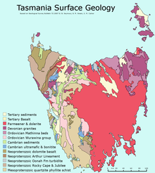
The island was adjoined to the mainland of Australia until the end of the last glacial period about 11,700 years ago.[19] Much of the island is composed of Jurassic dolerite intrusions (the upwelling of magma) through other rock types, sometimes forming large columnar joints. Tasmania has the world's largest areas of dolerite, with many distinctive mountains and cliffs formed from this rock type. The central plateau and the southeast portions of the island are mostly dolerites. Mount Wellington above Hobart is a good example, showing distinct columns known as the Organ Pipes.
In the southern midlands as far south as Hobart, the dolerite is underlaid by sandstone and similar sedimentary stones. In the southwest, Precambrian quartzites were formed from very ancient sea sediments and form strikingly sharp ridges and ranges, such as Federation Peak or Frenchmans Cap.
In the northeast and east, continental granites can be seen, such as at Freycinet, similar to coastal granites on mainland Australia. In the northwest and west, mineral-rich volcanic rock can be seen at Mount Read near Rosebery, or at Mount Lyell near Queenstown. Also present in the south and northwest is limestone with caves.
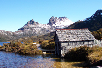
The quartzite and dolerite areas in the higher mountains show evidence of glaciation, and much of Australia's glaciated landscape is found on the Central Plateau and the Southwest. Cradle Mountain, another dolerite peak, for example, was a nunatak. The combination of these different rock types contributes to scenery which is distinct from any other region of the world.[citation needed] In the far southwest corner of the state, the geology is almost wholly quartzite, which gives the mountains the false impression of having snow-capped peaks year round.
Aboriginal people

Evidence indicates the presence of Aboriginal people in Tasmania about 42,000 years ago. Rising sea levels cut Tasmania off from mainland Australia about 10,000 years ago and by the time of European contact, the Aboriginal people in Tasmania had nine major nations or ethnic groups.[32] At the time of the British occupation and colonisation in 1803, the indigenous population was estimated at between 3,000 and 10,000.
Historian Lyndall Ryan's analysis of population studies led her to conclude that there were about 7,000 spread throughout the island's nine nations;[33] Nicholas Clements, citing research by N.J.B. Plomley and Rhys Jones, settled on a figure of 3,000 to 4,000.[34] They engaged in fire-stick farming, hunted game including kangaroo and wallabies, caught seals, mutton-birds, shellfish and fish and lived as nine separate "nations" on the island, which they knew as "Trouwunna".
European arrival and governance

The first reported sighting of Tasmania by a European was on 24 November 1642 by Dutch explorer Abel Tasman, who landed at today's Blackman Bay. More than a century later, in 1772, a French expedition led by Marc-Joseph Marion du Fresne landed at (nearby but different) Blackmans Bay, and the following year Tobias Furneaux became the first Englishman to land in Tasmania when he arrived at Adventure Bay, which he named after his ship HMS Adventure. Captain James Cook also landed at Adventure Bay in 1777. Matthew Flinders and George Bass sailed through Bass Strait in 1798–1799, determining for the first time that Tasmania was an island.[35]
Sealers and whalers based themselves on Tasmania's islands from 1798,[36] and in August 1803 New South Wales Governor Philip King sent Lieutenant John Bowen to establish a small military outpost on the eastern shore of the Derwent River in order to forestall any claims to the island by French explorers who had been exploring the southern Australian coastline. Bowen, who led a party of 49, including 21 male and three female convicts, named the camp Risdon.[35][37]
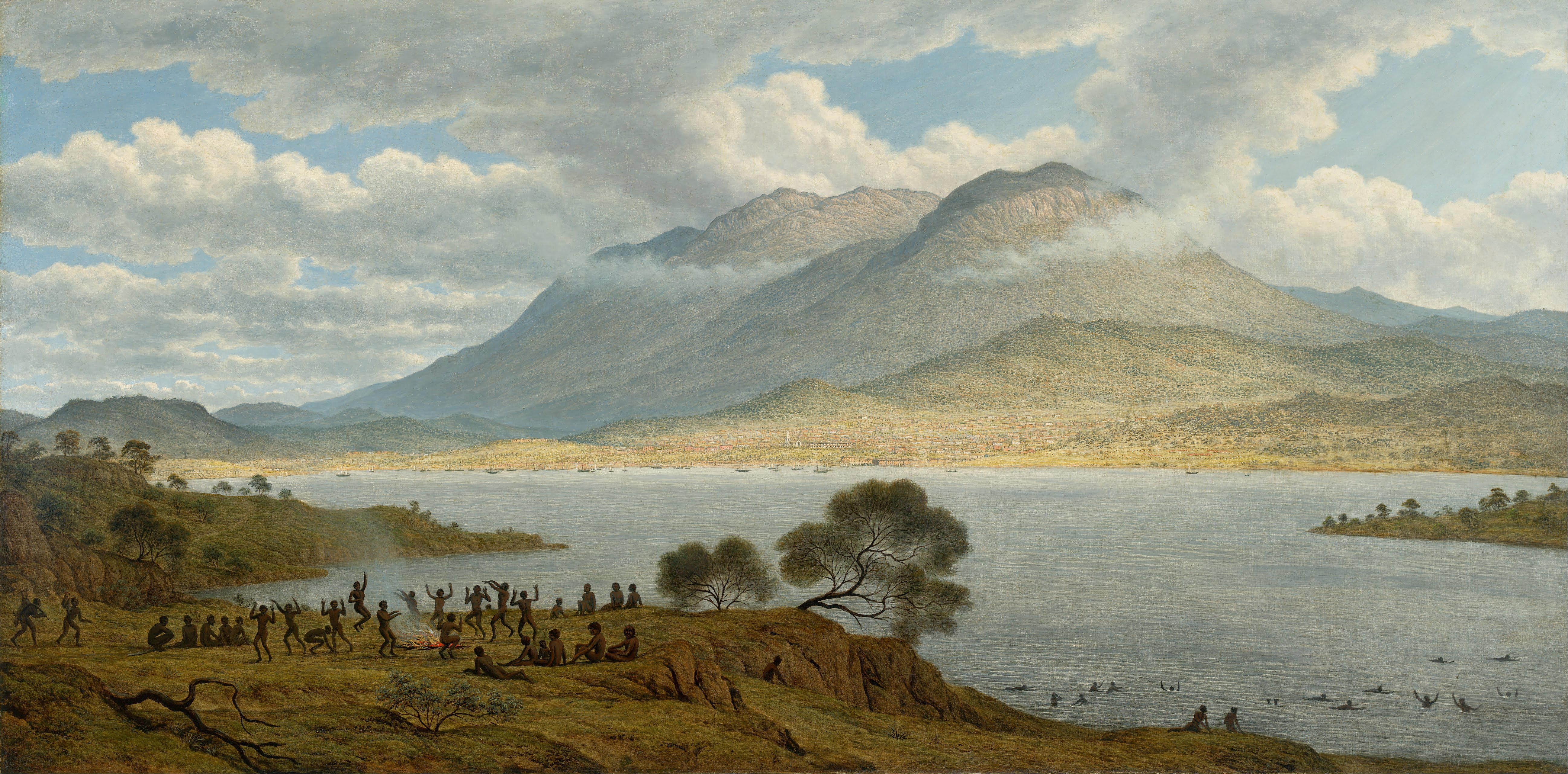
Several months later a second settlement was established by Captain David Collins, with 308 convicts, 5 kilometres (3.1 miles) to the south in Sullivans Cove on the western side of the Derwent, where fresh water was more plentiful. The latter settlement became known as Hobart Town or Hobarton, later shortened to Hobart, after the British Colonial Secretary of the time, Lord Hobart. The settlement at Risdon was later abandoned. Left on their own without further supplies, the Sullivans Cove settlement suffered severe food shortages and by 1806 its inhabitants were starving, with many resorting to scraping seaweed off rocks and scavenging washed-up whale blubber from the shore to survive.[35]
A smaller colony was established at Port Dalrymple on the Tamar River in the island's north in October 1804 and several other convict-based settlements were established, including the particularly harsh penal colonies at Port Arthur in the southeast and Macquarie Harbour on the West Coast. Tasmania was eventually sent 75,000 convicts—four out of every ten people transported to Australia.[35] By 1819 the Aboriginal and British population reached parity with about 5000 of each, although among the colonists men outnumbered women four-to-one.[38] Free settlers began arriving in large numbers from 1820, lured by the promise of land grants and free convict labour. Settlement in the island's northwest corner was monopolised by the Van Diemen's Land Company, which sent its first surveyors to the district in 1826. By 1830 one-third of Australia's non-Indigenous population lived in Van Diemen's Land and the island accounted for about half of all land under cultivation and exports.[39]
Black War

Tensions between Tasmania's Aboriginal and white inhabitants rose, partly driven by increasing competition for kangaroo and other game.[40][41][42] Explorer and naval officer John Oxley in 1810 noted the "many atrocious cruelties" inflicted on Aboriginal people by convict bushrangers in the north, which in turn led to black attacks on solitary white hunters.[43] Hostilities increased further with the arrival of 600 colonists from Norfolk Island between 1807 and 1813. They established farms along the River Derwent and east and west of Launceston, occupying ten percent of Van Diemen's Land. By 1824 the colonial population had swelled to 12,600, while the island's sheep population had reached 200,000. The rapid colonisation transformed traditional kangaroo hunting grounds into farms with grazing livestock as well as fences, hedges and stone walls, while police and military patrols were increased to control the convict farm labourers.[44]
Violence began to spiral rapidly from the mid-1820s in what became described as the "Black War".[45] Aboriginal inhabitants were driven to desperation by hunger - that included a desire for agricultural produce, as well as feeling anger at the prevalence of abductions of women and girls. New settlers motivated by fear carried out self-defence operations as well as attacks as a means of suppressing the native threat - or even in some cases, exacting revenge.[46] Van Diemen's Land had an enormous gender imbalance, with male colonists outnumbering females six to one in 1822—and 16 to one among the convict population. Historian Nicholas Clements has suggested the "voracious appetite" for native women was the most important trigger for the explosion of violence from the late 1820s.[47]
From 1825 to 1828 the number of native attacks more than doubled each year, raising panic among settlers. Over the summer of 1826–1827 clans from the Big River, Oyster Bay and North Midlands nations speared stock-keepers on farms and made it clear that they wanted the settlers and their sheep and cattle to move from their kangaroo hunting grounds. Settlers responded vigorously, resulting in many mass-killings. In November 1826 Governor Sir George Arthur issued a government notice declaring that colonists were free to kill Aboriginal people when they attacked settlers or their property and in the following eight months more than 200 Aboriginal people were killed in the Settled Districts in reprisal for the deaths of 15 colonists. After another eight months the death toll had risen to 43 colonists and probably 350 Aboriginal people.[48] In April 1828, Arthur issued a Proclamation of Demarcation forbidding Aboriginal people to enter the settled districts without a passport issued by the government.[49][50] Arthur declared martial law in the colony in November that year, and this remained in force for over three years, the longest period of martial law in Australian history.[51][52]
In November 1830 Arthur organised the so-called "Black Line", ordering every able-bodied male colonist to assemble at one of seven designated places in the Settled Districts to join a massive drive to sweep Aboriginal people out of the region and on to the Tasman Peninsula. The campaign failed and was abandoned seven weeks later, but by then Tasmania's Aboriginal population had fallen to about 300.[53]
Removal of Aboriginal people
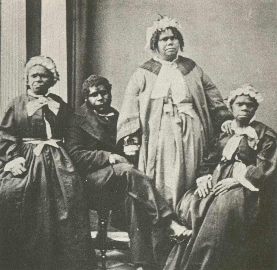
After hostilities between settlers and Aboriginal peoples ceased in 1832, almost all of the remnants of the Indigenous population were persuaded or forced by government agent George Augustus Robinson to move to Flinders Island. Many quickly succumbed to infectious diseases to which they had no immunity, reducing the population further.[54][55] Of those removed from Tasmania, the last to die was Truganini, in 1876.
The near-destruction of Tasmania's Aboriginal population has been described as an act of genocide by historians including Robert Hughes, James Boyce, Lyndall Ryan and Tom Lawson.[35][56][57] However, other historians including Henry Reynolds, Richard Broome and Nicholas Clements do not agree with the genocide thesis, arguing that the colonial authorities did not intend to destroy the Aboriginal population in whole or in part.[58][59] Boyce has claimed that the April 1828 "Proclamation Separating the Aborigines from the White Inhabitants" sanctioned force against Aboriginal people "for no other reason than that they were Aboriginal".[60] However, as Reynolds, Broome and Clements point out, there was open warfare at the time.[58][59] Boyce described the decision to remove all Tasmanian Aboriginal people after 1832—by which time they had given up their fight against white colonists—as an extreme policy position. He concluded: "The colonial government from 1832 to 1838 ethnically cleansed the western half of Van Diemen's Land."[60] Nevertheless, Clements and Flood note that there was another wave of violence in north-west Tasmania in 1841, involving attacks on settlers' huts by a band of Aboriginal Tasmanians who had not been removed from the island.[61][62]
Proclamation as a colony (1825) and change of name (1856)

Van Diemen's Land—which thus far had existed as a territory within the colony of New South Wales—was proclaimed a separate colony, with its own judicial establishment and Legislative Council, on 3 December 1825. Transportation to the island ceased in 1853 and the colony was renamed Tasmania in 1856, partly to differentiate the burgeoning society of free settlers from the island's convict past.[63]
The Legislative Council of Van Diemen's Land drafted a new constitution which gained Royal Assent in 1855. The Privy Council also approved the colony changing its name from "Van Diemen's Land" to "Tasmania", and in 1856 the newly elected bicameral parliament sat for the first time, establishing Tasmania as a self-governing colony of the British Empire.[64]
The colony suffered from economic fluctuations, but for the most part was prosperous, experiencing steady growth. With few external threats and strong trade links with the Empire, Tasmania enjoyed many fruitful periods in the late 19th century, becoming a world-centre of shipbuilding. It raised a local defence force that eventually played a significant role in the Second Boer War in South Africa, and Tasmanian soldiers in that conflict won the first two Victoria Crosses awarded to Australians.
Federation
In 1901 the Colony of Tasmania united with the five other Australian colonies to form the Commonwealth of Australia. Tasmanians voted in favour of federation with the largest majority of all the Australian colonies.
20th and 21st century
Tasmania was the first place in the southern hemisphere to have electric lights, starting with Launceston in 1885 and Zeehan in 1900. The state economy was riding mining prosperity until World War I. In 1901, the state population was 172,475.[65] The 1910 foundation of what would become Hydro Tasmania began to shape urban patterns, as well as future major damming programs.[66] Hydro's influence culminated in the 1970s when the state government announced plans to flood environmentally significant Lake Pedder. As a result of the eventual flooding of Lake Pedder, the world's first green party was established; the United Tasmania Group.[67] National and international attention surrounded the campaign against the Franklin Dam in the early 1980s.
In 1943, Enid Lyons was elected the first female member of the Australian House of Representatives, winning the seat of Darwin.
After the end of World War II, the state saw major urbanisation, and the growth of towns like Ulverstone.[66] It gained a reputation as "Sanitorium of the South" and a health-focused tourist boom began to grow. The MS Princess of Tasmania began her maiden voyage in 1959, the first car ferry to Tasmania.[66] As part of the boom, Tasmania allowed the opening of the first casino in Australia in 1968[66] Queen Elizabeth II visited the state in 1954, and the 50s and 60s were charactered by the opening of major public services, including the Tasmanian Housing Department and Metro Tasmania public bus services. A jail was opened at Risdon in 1960, and the State Library of Tasmania the same year. The University of Tasmania also moved to its present location in 1963.
The state was badly affected by the 1967 Tasmanian fires, killing 62 people and destroying over 652,000 acres in five hours. In 1975 the Tasman Bridge collapsed when the bridge was struck by the bulk ore carrier Lake Illawarra. It was the only bridge in Hobart, and made crossing the Derwent River by road at the city impossible. The nearest bridge was approximately 20 kilometres (12 mi) to the north, at Bridgewater.
Throughout the 1980s, strong environmental concerns saw the building of the Australian Antarctic Division headquarters, and the proclamation of the Tasmanian Wilderness World Heritage Area. The Franklin Dam was blocked by the federal government in 1983, and CSIRO opened its marine studies center in Hobart. Pope John Paul II would hold mass at Elwick Racecourse in 1986.
The 1990s were characterised by the fight for LGBT rights in Tasmania, culminating in the intervention of the United Nations Human Rights Committee in 1997 and the decriminalization of homosexuality that year. Christine Milne became the first female leader of a Tasmanian political party in 1993, and major council amalgamations reduce the number of councils from 46 to 29.
On 28 April 1996, in the Port Arthur massacre, lone gunman Martin Bryant shot and killed 35 people (including tourists and residents) and injured 21 others. The use of firearms was immediately reviewed, and new gun ownership laws were adopted nationwide, with Tasmania's law one of the strictest in Australia.
In 2000, Queen Elizabeth II once again visited the state. Gunns rose to prominence as a major forestry company during this decade, only to collapse in 2013. In 2004, Premier Jim Bacon died in office from lung cancer. In January 2011 philanthropist David Walsh opened the Museum of Old and New Art (MONA) in Hobart to international acclaim. Within 12 months, MONA became Tasmania's top tourism attraction.[68]

The COVID-19 pandemic in Tasmania resulted in at least 230 cases and 13 deaths as of September 2021[update].[69] In 2020, after the outbreak of the coronavirus pandemic (SARS-CoV-2) and its spread to Australia, the Tasmanian government issued a public health emergency on 17 March,[70] the following month receiving the state's most significant outbreak from the North-West which required assistance from the Federal government. In late 2021, Tasmania was leading the nationwide vaccination response.[71]
Geography
This article or section may need to be cleaned up or summarized because it has been split from/to Geography of Tasmania. |

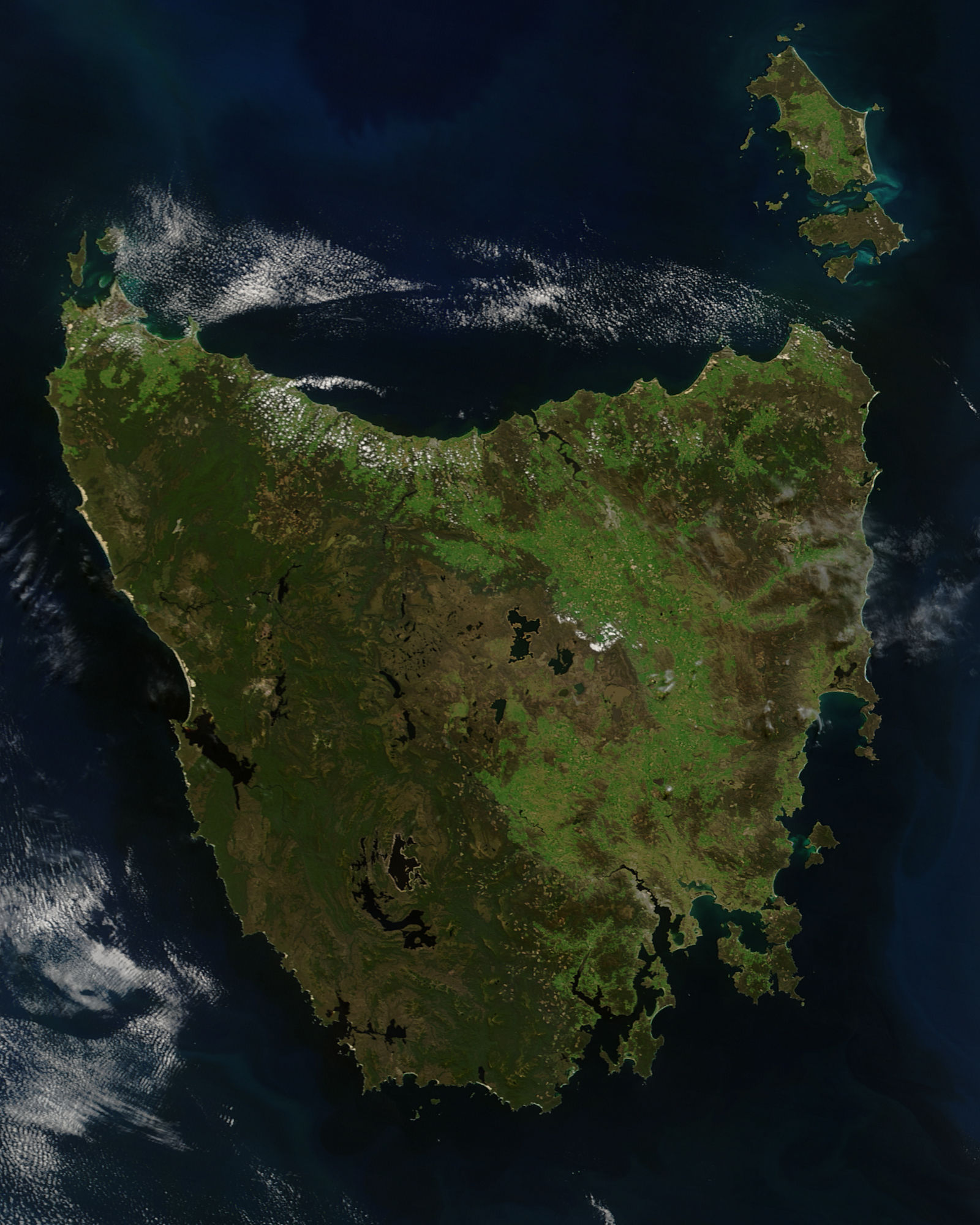
Tasmania, the largest island of Australia, has a landmass of 68,401 km2 (26,410 sq mi) and is located directly in the pathway of the notorious "Roaring Forties" wind that encircles the globe. To its north, it is separated from mainland Australia by Bass Strait. Tasmania is the only Australian state that is not located on the Australian mainland. About 2,500 kilometres (1,300 nautical miles) south of Tasmania island lies the George V Coast of Antarctica. Depending on which borders of the oceans are used, the island can be said to be either surrounded by the Southern Ocean, or to have the Pacific on its east and the Indian to its west. Still other definitions of the ocean boundaries would have Tasmania with the Great Australian Bight to the west, and the Tasman Sea to the east. The southernmost point on mainland Tasmania is approximately 43°38′37″S 146°49′38″E at South East Cape, and the northernmost point on mainland Tasmania is approximately 40°38′26″S 144°43′33″E in Woolnorth / Temdudheker near Cape Grim / Kennaook. Tasmania lies at similar latitudes to Te Waipounamu / South Island of New Zealand, and parts of Patagonia in South America, and relative to the Northern Hemisphere, it lies at similar latitudes to Hokkaido in Japan, Northeast China (Manchuria), the north Mediterranean in Europe, and the Canada-United States border.

The most mountainous region is the Central Highlands area, which covers most of the central western parts of the state. The Midlands located in the central east, is fairly flat, and is predominantly used for agriculture, although farming activity is scattered throughout the state. Tasmania's tallest mountain is Mount Ossa at 1,617 m (5,305 ft).[72] Much of Tasmania is still densely forested, with the Southwest National Park and neighbouring areas holding some of the last temperate rain forests in the Southern Hemisphere. The Tarkine, containing Savage River National Park located in the island's far north west, is the largest temperate rainforest area in Australia covering about 3,800 square kilometres (1,500 sq mi).[73] With its rugged topography, Tasmania has a great number of rivers. Several of Tasmania's largest rivers have been dammed at some point to provide hydroelectricity. Many rivers begin in the Central Highlands and flow out to the coast. Tasmania's major population centres are mainly situated around estuaries (some of which are named rivers).
Tasmania is in the shape of a downward-facing triangle, likened to a shield, heart, or face. It consists of the main island as well as at least a thousand neighbouring islands within the state's jurisdiction. The largest of these are Flinders Island in the Furneaux Group of Bass Strait, King Island in the west of Bass Strait, Cape Barren Island south of Flinders Island, Bruny Island separated from Tasmania by the D'Entrecasteaux Channel, Macquarie Island 1,500 km from Tasmania, and Maria Island off the east coast. Tasmania features a number of separated and continuous mountain ranges. The majority of the state is defined by a significant dolerite exposure, though the western half of the state is older and more rugged, featuring buttongrass plains, temperate rainforests, and quartzite ranges, notably Federation Peak and Frenchmans Cap. The presence of these mountain ranges is a primary factor in the rain shadow effect, where the western half receives the majority of rainfall, which also influences the types of vegetation that can grow. The Central Highlands feature a large plateau which forms a number of ranges and escarpments on its north side, tapering off along the south, and radiating into the highest mountain ranges in the west. At the north-west of this, another plateau radiates into a system of hills where takayna / Tarkine is located.
The Interim Biogeographic Regionalisation for Australia (IBRA) divides Tasmania into 9 bioregions:[74] Ben Lomond, Furneaux, King, Central Highlands, Northern Midlands, Northern Slopes, Southern Ranges, South East, and West.


Environment
Tasmania's environment consistes of many different biomes or communities across its different regions. It is the most forested state in Australia, and preserves the country's largest areas of temperate rainforest. A distinctive type of moorland found across the west, and particularly south-west of Tasmania, are buttongrass plains, which are speculated to have been expanded by Tasmanian Aboriginal burning practices.[75] Tasmania also features a diverse alpine garden environment, such as cushion plant. Highland areas receive consistent snowfall above ~1,000 metres every year, and due to cold air from Antarctica, this level often reaches 800 m, and more occasionally 600 or 400 metres. Every five or so years, snow can form at sea level.[76] This environment gives rise to the cypress forests of the Central Plateau and mountainous highlands. In particular, the Walls of Jerusalem with large areas of rare pencil pine, and its closest relative King Billy pine. On the West Coast Range and partially on Mount Field, Australia's only winter-deciduous plant, deciduous beech is found, which forms a carpet or krummholz, or very rarely a 4-metre tree.[77]
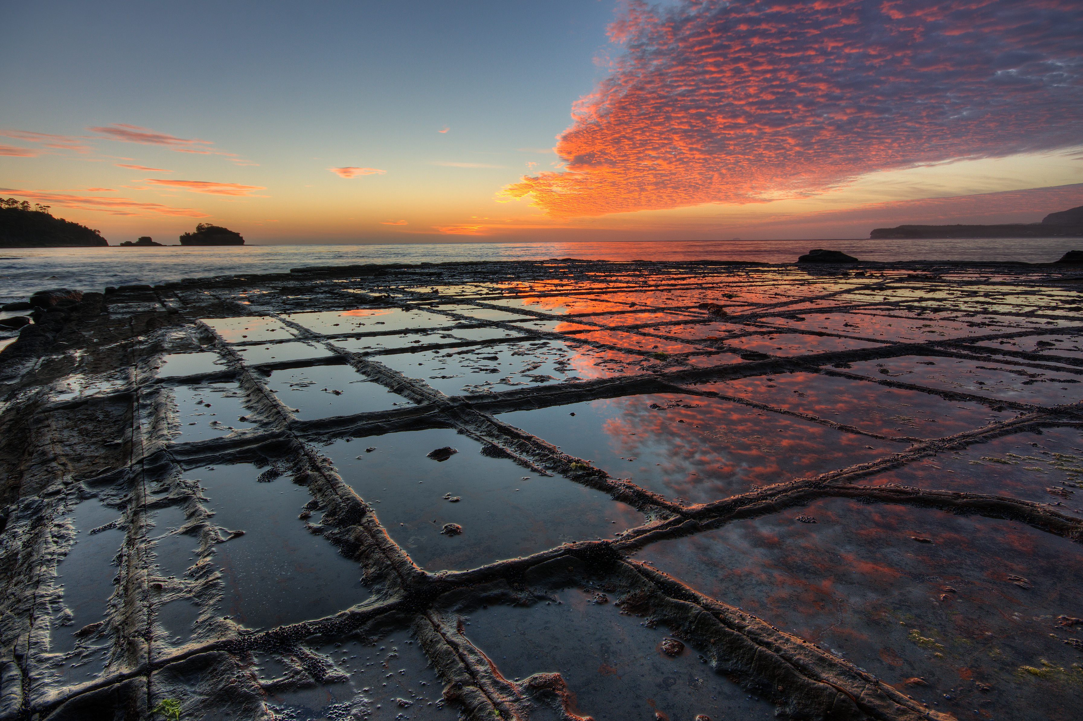
Tasmania features a high concentration of waterfalls. These can be found in small creeks, alpine streams, rapid rivers, or off precipitous plunges. Some of the tallest waterfalls are found on mountain massifs, sometimes at a 200-metre cascade. The most famous and most visited waterfall in Tasmania is Russell Falls in Mount Field due to its proximity to Hobart and stepped falls at a total height of 58 metres.[78] Tasmania also has a large number of beaches, the longest of which is Ocean Beach on the West Coast at about 40 kilometres.[79] Wineglass Bay in Freycinet on the east coast is a well-known landmark of the state.
The Tasmanian temperate rainforests cover a few different types. These are also considered distinct from the more common wet sclerophyll forests, though these eucalypt forests often form with rainforest understorey and ferns (such as tree-ferns) are usually never absent. Rainforest found in deep gullies are usually difficult to traverse due to dense understorey growth, such as from horizontal (Anodopetalum biglandulosum). Higher-elevation forests (~500 to 800 m) have smaller ground vegetation and are thus easier to walk in. The most common rainforests usually have a 50-metre[80] canopy and are varied by environmental factors. Emergent growth usually comes from eucalyptus, which can tower another 50 metres higher (usually less), providing the most common choice of nesting for giant wedge-tailed eagles.
The human environment ranges from urban or industrial development, to farming or grazing land. The most cultivated area is the Midlands, where it has suitable soil but is also the driest part of the state.
Insularity
Tasmania's insularity was possibly detected by Captain Abel Tasman when he charted Tasmania's coast in 1642. On 5 December, Tasman was following the east coast northward to see how far it went. When the land veered to the north-west at Eddystone Point,[81] he tried to keep in with it but his ships were suddenly hit by the Roaring Forties howling through Bass Strait.[82] Tasman was on a mission to find the Southern Continent, not more islands, so he abruptly turned away to the east and continued his continent-hunting.[83]
The next European to enter the strait was Captain James Cook on HMS Endeavour in April 1770. However, after sailing for two hours westward into the strait against the wind, he turned back east and noted in his journal that he was "doubtful whether they [i.e. Van Diemen's Land and New Holland] are one land or no".[84]
The strait was named after George Bass, after he and Matthew Flinders passed through it while circumnavigating Van Diemen's Land in the Norfolk in 1798–99. At Flinders' recommendation, the Governor of New South Wales, John Hunter, in 1800 named the stretch of water between the mainland and Van Diemen's Land "Bass's Straits".[85] Later it became known as Bass Strait.
The existence of the strait had been suggested in 1797 by the master of Sydney Cove when he reached Sydney after deliberately grounding his foundering ship and being stranded on Preservation Island (at the eastern end of the strait). He reported that the strong south westerly swell and the tides and currents suggested that the island was in a channel linking the Pacific and southern Indian Ocean. Governor Hunter thus wrote to Joseph Banks in August 1797 that it seemed certain a strait existed.[86]
Climate

Tasmania has a relatively cool temperate climate compared to the rest of Australia, spared from the hot summers of the mainland and experiencing four distinct seasons.[87] Summer is from December to February when the average maximum sea temperature is 21 °C (70 °F) and inland areas around Launceston reach 24 °C (75 °F). Other inland areas are much cooler, with Liawenee, located on the Central Plateau, one of the coldest places in Australia, ranging between 4 °C (39 °F) and 17 °C (63 °F) in February. Autumn is from March to May, with mostly settled weather, as summer patterns gradually take on the shape of winter patterns.[88] The winter months are from June to August, and are generally the wettest and coldest months in the state, with most high lying areas receiving considerable snowfall. Winter maximums are 12 °C (54 °F) on average along coastal areas and 3 °C (37 °F) on the central plateau, as a result of a series of cold fronts from the Southern Ocean. Inland areas receive regular freezes throughout the winter months. Spring is from September to November, and is an unsettled season of transition, where winter weather patterns begin to take the shape of summer patterns, although snowfall is still common up until October. Spring is generally the windiest time of the year with afternoon sea breezes starting to take effect on the coast.
| City/town | Mean min. temp °C | Mean max. temp °C | No. clear days | Rainfall (mm) |
|---|---|---|---|---|
| Hobart | 8.3 | 16.9 | 41 | 616[89] |
| Launceston | 7.0 | 18.3 | 50 | 666[90] |
| Devonport | 8.0 | 16.8 | 61 | 778[91] |
| Strahan | 7.9 | 16.5 | 41 | 1,458[92] |
| Climate data for Hobart (Battery Point) | |||||||||||||
|---|---|---|---|---|---|---|---|---|---|---|---|---|---|
| Month | Jan | Feb | Mar | Apr | May | Jun | Jul | Aug | Sep | Oct | Nov | Dec | Year |
| Record high °C (°F) | 41.8 (107.2) |
40.1 (104.2) |
39.1 (102.4) |
31.0 (87.8) |
25.7 (78.3) |
20.6 (69.1) |
22.1 (71.8) |
24.5 (76.1) |
31.0 (87.8) |
34.6 (94.3) |
36.8 (98.2) |
40.6 (105.1) |
41.8 (107.2) |
| Average high °C (°F) | 22.7 (72.9) |
22.2 (72.0) |
20.7 (69.3) |
17.9 (64.2) |
15.3 (59.5) |
12.7 (54.9) |
12.6 (54.7) |
13.7 (56.7) |
15.7 (60.3) |
17.6 (63.7) |
19.1 (66.4) |
21.0 (69.8) |
17.6 (63.7) |
| Average low °C (°F) | 13.0 (55.4) |
12.8 (55.0) |
11.6 (52.9) |
9.4 (48.9) |
7.6 (45.7) |
5.5 (41.9) |
5.2 (41.4) |
5.6 (42.1) |
6.9 (44.4) |
8.3 (46.9) |
10.0 (50.0) |
11.6 (52.9) |
9.0 (48.2) |
| Record low °C (°F) | 3.3 (37.9) |
3.4 (38.1) |
1.8 (35.2) |
0.7 (33.3) |
−1.6 (29.1) |
−2.8 (27.0) |
−2.8 (27.0) |
−1.8 (28.8) |
−0.8 (30.6) |
0.0 (32.0) |
0.3 (32.5) |
3.3 (37.9) |
−2.8 (27.0) |
| Average rainfall mm (inches) | 43.7 (1.72) |
37.8 (1.49) |
37.0 (1.46) |
42.6 (1.68) |
39.2 (1.54) |
46.0 (1.81) |
44.5 (1.75) |
63.0 (2.48) |
55.6 (2.19) |
52.8 (2.08) |
50.7 (2.00) |
53.0 (2.09) |
565.9 (22.28) |
| Average rainy days (≥ 0.2 mm) | 9.5 | 9.1 | 11.3 | 11.1 | 12.0 | 12.4 | 14.1 | 15.3 | 15.7 | 15.0 | 13.5 | 11.7 | 150.7 |
| Average afternoon relative humidity (%) | 51 | 52 | 52 | 56 | 58 | 64 | 61 | 56 | 53 | 51 | 53 | 49 | 55 |
| Mean monthly sunshine hours | 257.3 | 226.0 | 210.8 | 177.0 | 148.8 | 132.0 | 151.9 | 179.8 | 195.0 | 232.5 | 234.0 | 248.0 | 2,393.1 |
| Percent possible sunshine | 59 | 62 | 57 | 59 | 53 | 49 | 53 | 58 | 59 | 58 | 56 | 53 | 56 |
| Source 1: Bureau of Meteorology (1991–2020 averages;[93] extremes 1882–present)[94][95][96] | |||||||||||||
| Source 2: Bureau of Meteorology, Hobart Airport (sunshine hours)[97] | |||||||||||||
| Climate data for Launceston (Ti Tree Bend) | |||||||||||||
|---|---|---|---|---|---|---|---|---|---|---|---|---|---|
| Month | Jan | Feb | Mar | Apr | May | Jun | Jul | Aug | Sep | Oct | Nov | Dec | Year |
| Record high °C (°F) | 39.0 (102.2) |
34.4 (93.9) |
33.0 (91.4) |
27.7 (81.9) |
22.0 (71.6) |
18.4 (65.1) |
18.4 (65.1) |
20.3 (68.5) |
24.8 (76.6) |
28.7 (83.7) |
30.7 (87.3) |
33.8 (92.8) |
39.0 (102.2) |
| Average high °C (°F) | 24.8 (76.6) |
24.6 (76.3) |
22.7 (72.9) |
18.9 (66.0) |
15.8 (60.4) |
13.3 (55.9) |
12.8 (55.0) |
13.8 (56.8) |
15.7 (60.3) |
18.2 (64.8) |
20.5 (68.9) |
22.7 (72.9) |
18.7 (65.7) |
| Average low °C (°F) | 12.6 (54.7) |
12.5 (54.5) |
10.3 (50.5) |
7.5 (45.5) |
5.0 (41.0) |
2.9 (37.2) |
2.5 (36.5) |
3.5 (38.3) |
5.2 (41.4) |
7.0 (44.6) |
9.1 (48.4) |
10.9 (51.6) |
7.4 (45.3) |
| Record low °C (°F) | 2.5 (36.5) |
3.4 (38.1) |
0.5 (32.9) |
−1.5 (29.3) |
−3 (27) |
−4.9 (23.2) |
−5.2 (22.6) |
−3.6 (25.5) |
−3.4 (25.9) |
−1.4 (29.5) |
−2.0 (28.4) |
2.0 (35.6) |
−5.2 (22.6) |
| Average rainfall mm (inches) | 51.5 (2.03) |
35.2 (1.39) |
38.8 (1.53) |
51.0 (2.01) |
63.1 (2.48) |
66.9 (2.63) |
78.3 (3.08) |
83.8 (3.30) |
65.5 (2.58) |
48.0 (1.89) |
52.9 (2.08) |
45.8 (1.80) |
680.8 (26.80) |
| Average rainy days (≥ 1 mm) | 4.8 | 4.6 | 4.4 | 6.5 | 7.6 | 8.3 | 9.7 | 10.9 | 10.0 | 7.5 | 7.0 | 5.8 | 87.1 |
| Average afternoon relative humidity (%) | 48 | 49 | 48 | 56 | 63 | 69 | 69 | 63 | 59 | 54 | 52 | 49 | 57 |
| Mean monthly sunshine hours | 285.2 | 256.9 | 241.8 | 198.0 | 155.0 | 135.0 | 142.6 | 170.5 | 201.0 | 254.2 | 267.0 | 282.1 | 2,589.3 |
| Source 1: Bureau of Meteorology (1991–2020 averages;[98] extremes 1980–present)[99] | |||||||||||||
| Source 2: Bureau of Meteorology, Launceston Airport (1981–2004 sunshine hours)[100] | |||||||||||||
Soils

Despite the presence of some Quaternary glaciation, Tasmania's soils are not more fertile than those of mainland Australia, largely because most are severely leached and the areas with driest climates (least leaching) were unaffected by glaciation or alluvia derived therefrom. Most soils on the Bass Strait Islands, the east coast and western Tasmania are very infertile spodosols or psamments, with some even less fertile "lateritic podzolic soils" in the latter region. Most of these lands are thus not used for agriculture, but there is much productive forestry in Tasmania—which remains one of the state's major industries.
On the north coast, apart from some relatively fertile alluvial soils used for fruit-growing, there are also deep red, easily workable soils known as "krasnozems" ("red land"). These soils are highly acidic and fix phosphate very effectively, but their extremely favourable physical properties make them extensively used for dairying, beef cattle and fodder crops.
The Midlands and the Lower Derwent present a different story from the rest of the state. Owing to a relatively dry climate and alkaline (mostly dolerite) parent material, these soils are relatively unleached and contain lime in the deeper subsoil. They are mostly classified as "prairie soils" or "brown earths" and bear some resemblance to the chernozems of Russia and North America, although they are much lower in available phosphorus and somewhat acidic in the surface levels. Their higher nutrient levels, however, allow them to support productive pasture, and large numbers of sheep are grazed in these regions. Some grain crops are also grown in the driest areas. In the alluvial areas of southeastern Tasmania, rich alluvial soils permit apples to be grown.
Tasmania became known as the "Apple Isle" because for many years it was one of the world's major apple producers. Apples are still grown in large numbers, particularly in southern Tasmania.[101]
Ecology


Geographically and biological isolated, Tasmania is known for its unique endemic flora and fauna.
Flora
Tasmania has extremely diverse vegetation, from the heavily grazed grassland of the dry Midlands to the tall evergreen eucalypt forest, alpine heathlands and large areas of cool temperate rainforests and moorlands in the rest of the state. Many species are unique to Tasmania and some are related to species in South America and New Zealand through ancestors which grew on the supercontinent of Gondwana, 50 million years ago. Nothofagus gunnii, commonly known as Australian beech, is Australia's only temperate native deciduous tree and is found exclusively in Tasmania.[102]
Distinctive species of plant in Tasmania include:
- Eucalyptus regnans (mountain ash) – the tallest flowering plant and hardwood in the world, reaching 100 m (328 ft).[103]
- Nothofagus cunninghamii (myrtle beech) – the most abundant temperate rainforest canopy species found in Tasmania.
- Nothofagus gunnii (deciduous beech) – Australia's only winter-deciduous tree.
- Atherosperma moschatum (blackheart sassafras) – a co-dominant rainforest tree with a nutmeg aroma.
- Lagarostrobos franklinii (Huon pine) – one of the oldest-lived tree species, and a self-preserving timber.
- Phyllocladus aspleniifolius (celery-top pine) – a celery-leaved conifer found in rainforests.
- Athrotaxis (Tasmanian cedar/redwood) – a genus comprising three extant species related to sequoia found in Tasmania.[104]
- Eucryphia lucida (leatherwood) – a prominent floral symbol of Tasmania and a unique monofloral honey species.[105]
Bush tucker
Tasmania also has a number of native edibles, known as bush tucker in Australia. These plants were foraged by the Tasmanian Aboriginals and also used for other purposes, such as construction. Unusual trees such as cider gum (Eucalyptus gunnii) had their manna used to make a syrup or an alcohol (cider). Other trees such as wattles (acacias) like blackwood (Acacia melanoxylon) and mimosa (Acacia dealbata) could have their seeds eaten or crushed into a powder. There are also many berries such as snowberry (Gaultheria hispida), fruits such as heartberry (Aristotelia peduncularis), and vegetables such as river mint (Mentha australis), though no crops like maize that are used for large production.[106]
Fauna
Tasmania has a large percentage of endemism whilst featuring many types of animals found on mainland Australia. Many of these species, such as the platypus are larger than their mainland relatives.[107] The island of Tasmania was home to the thylacine, a marsupial which resembled a fossa or some say a wild dog. Known colloquially as the Tasmanian tiger for the distinctive striping across its back, it became extinct in mainland Australia much earlier because of competition by the dingo, introduced in prehistoric times. Owing to persecution by farmers, government-funded bounty hunters and, in the final years, collectors for overseas museums, it appears to have been exterminated in Tasmania. The Tasmanian devil became the largest carnivorous marsupial in the world following the extinction of the thylacine in 1936, and is now found in the wild only in Tasmania. Tasmania was one of the last regions of Australia to be introduced to domesticated dogs. Dogs were brought from Britain in 1803 for hunting kangaroos and emus. This introduction completely transformed Aboriginal society, as it helped them to successfully compete with European hunters, and was more important than the introduction of guns for the Aboriginal people.[108]
Tasmania is a hotspot for giant habitat trees and the large animal species that occupy them, notably the endangered Tasmanian wedge-tailed eagle (Aquila audax fleayi), the Tasmanian masked owl (Tyto novaehollandiae castanops), the Tasmanian giant freshwater crayfish (Astacopsis gouldi), the yellow wattlebird (Anthochaera paradoxa), the green rosella (Platycercus caledonicus) and others. Tasmania is also home to the world's only three migratory parrots, the critically endangered Orange-bellied parrot (Neophema chrysogaster), the Blue-winged parrot (Neophema chrysostoma), and the fastest parrot in the world, the swift parrot (Lathamus discolor).[109] Tasmania has 12 endemic species of bird in total.[110]
Mycology
Tasmania is a hotspot for fungal diversity. The importance of fungi in Tasmania's ecology is often overlooked, but nonetheless they play a vital role in the natural vegetation cycle.[111]
Conservation
Like the rest of Australia, Tasmania suffers from an endangered species problem. In particular, many important Tasmanian subspecies and world-significant species of animal are classified as at risk in some way. A famous example is the Tasmanian devil, which is endangered due to devil facial tumour disease. Some species have already gone extinct, primarily due to human interference, such as in the case of the thylacine or the Tasmanian emu.[112][113] In Tasmania, there are about 90 endangered, vulnerable, or threatened vertebrate species classified by the state or Commonwealth governments.[114] Because of a reliance on roads and private vehicle transport, and a high concentration of animal populations divided by this development, Tasmania has the worst (per kilometre) roadkill rate in the world, with 32 animals killed per hour and at least 300,000 per year.[115]
Protected areas of Tasmania cover 21% of the island's land area in the form of national parks.[116] The Tasmanian Wilderness World Heritage Area (TWWHA) was inscribed by UNESCO in 1982, where it is globally significant because "most UNESCO World Heritage sites meet only one or two of the ten criteria for that status. The Tasmanian Wilderness World Heritage Area (TWWHA) meets 7 out of 10 criteria. Only one other place on earth—China’s Mount Taishan—meets that many criteria".[117] Controversy surrounds the decision in 2014 by the Abbott federal Liberal government to request the area's delisting and opening for resource exploration (before it was rejected by the UN Committee at Doha),[118] and the current mining and deforestation in the state's Tarkine region, the largest single temperate rainforest in Australia.[119][120]
Demography

Tasmania's population is more homogeneous than that of other states of Australia, with many of Irish and British descent.[121] Approximately 65% of its residents are descendants of an estimated 10,000 "founding families" from the mid-19th century.
Until 2012, Tasmania was the only state in Australia with an above-replacement total fertility rate; Tasmanian women had an average of 2.24 children each.[122] By 2012 the birth rate had slipped to 2.1 children per woman, bringing the state to the replacement threshold, but it continues to have the second-highest birth rate of any state or territory (behind the Northern Territory).[123]
Major population centres include Hobart, Launceston, Devonport, Burnie, and Ulverstone. Kingston is often defined as a separate city but is generally regarded as part of the Greater Hobart Area.[124]
| Cities and towns by population[125] | ||||||
|---|---|---|---|---|---|---|
| # | Settlement | Population | Metro population |
| ||
| 1 | Hobart[126] | 178,009 | 252,669 | |||
| 2 | Launceston | 68,813 | 110,472 | |||
| 3 | Devonport-Latrobe | 30,297 | ||||
| 4 | Burnie-Somerset | 19,385 | ||||
| 5 | Ulverstone | 14,490 | ||||
| 6 | Sorell-Dodges Ferry | 14,400 | ||||
| 7 | Kingston | 10,409 | ||||
| 8 | George Town | 7,117 | ||||
| 9 | Wynyard | 5,990 | ||||
| 10 | New Norfolk | 5,834 | ||||
| 11 | Smithton | 3,881 | ||||
| 12 | Penguin | 3,849 | ||||


| Name | Population |
|---|---|
| Greater Hobart | 226,884[17] |
| Launceston | 86,404[127] |
| Devonport | 30,044[127] |
| Burnie | 26,978[127] |
| Ulverstone | 14,424[127] |
Ancestry and immigration
| Birthplace[N 1] | Population |
|---|---|
| Australia | 411,490 |
| England | 18,776 |
| New Zealand | 4,997 |
| Mainland China | 3,036 |
| Scotland | 2,283 |
| Netherlands | 2,193 |
| Germany | 2,108 |
| India | 1,980 |
| United States | 1,630 |
| Philippines | 1,616 |
| South Africa | 1,524 |
| Malaysia | 1,409 |
At the 2016 census, the most commonly nominated ancestries were:[N 2][128][129]
19.3% of the population was born overseas at the 2016 census. The five largest groups of overseas-born were from England (3.7%), New Zealand (1%), Mainland China (0.6%), Scotland (0.4%) and the Netherlands (0.4%).[128][129]
4.6% of the population, or 23,572 people, identified as Indigenous Australians (Aboriginal Australians and Torres Strait Islanders) in 2016.[N 5][128][129]
Language
At the 2021 census, 86.1% of inhabitants spoke only English at home, with the next most common languages being Mandarin (1.5%), Nepali (1.3%), Punjabi (0.5%) and Spanish (0.3%).[131]
Religion
According to the 2021 Census, 50.0% of the Tasmanian population identified as having no religious affiliation. Christianity is followed by 38.4% of the population.[131] About 4.5% of people in Tasmania follows non-Christian religion mainly Hinduism (1.7%), Buddhism (1.0%) and Islam (0.9%). [131]
At the 2016 census, the most commonly nominated religions were Anglicanism (20.4%) and Catholicism (15.6%), while 37.8% of the population cited no religion.[128][129]
Government

The form of the government of Tasmania is prescribed in its constitution, which dates from 1856, although it has been amended many times since then. Since 1901, Tasmania has been a state of the Commonwealth of Australia, and the Australian Constitution regulates its relationship with the Commonwealth and prescribes which powers each level of government is allowed.
Tasmania is represented in the Senate by 12 senators, on an equal basis with all other states. In the House of Representatives, Tasmania is entitled to five seats, which is the minimum allocation for a state guaranteed by the Constitution—the number of House of Representatives seats for each state is otherwise decided on the basis of their relative populations, and Tasmania has never qualified for five seats on that basis alone. Tasmania's House of Assembly use a system of multi-seat proportional representation known as Hare-Clark.
Elections
At the 2002 state election, the Labor Party won 14 of the 25 House seats. The people decreased their vote for the Liberal Party; representation in the Parliament fell to seven seats. The Greens won four seats, with over 18% of the popular vote, the highest proportion of any Green party in any parliament in the world at that time.
| Composition of the Parliament of Tasmania | ||
|---|---|---|
| Political Party |
House of Assembly |
Legislative Council |
| ALP | 9 | 4 |
| Liberal | 13 | 4 |
| Greens | 2 | 0 |
| Independent | 1 | 6 |
| Source: Tasmanian Electoral Commission | ||
On 23 February 2004 the Premier Jim Bacon announced his retirement, after being diagnosed with lung cancer. In his last months he opened a vigorous anti-smoking campaign which included many restrictions on where individuals could smoke, such as pubs. He died four months later. Bacon was succeeded by Paul Lennon, who, after leading the state for two years, went on to win the 2006 state election in his own right. Lennon resigned in 2008 and was succeeded by David Bartlett, who formed a coalition government with the Greens after the 2010 state election resulted in a hung parliament. Bartlett resigned as Premier in January 2011 and was replaced by Lara Giddings, who became Tasmania's first female Premier. In March 2014 Will Hodgman's Liberal Party won government, ending sixteen years of Labor governance, and ending an eight-year period for Hodgman himself as Leader of the Opposition.[132] Hodgman then won a second term of government in the 2018 state election, but resigned mid-term in January 2020 and was replaced by Peter Gutwein.[133]
In May 2021, the Tasmanian state election was held after being called early by the incumbent Liberal Party, resulting in their return to government and establishment of a one-seat majority. It was also the first time that the Liberal Party had been elected three-times in a row.[134]
In April 2022, former deputy premier Jeremy Rockliff became Premier after Gutwein announced his retirement from politics.[135]
Politics
Tasmania has a number of undeveloped regions. Proposals for local economic development have been faced with requirements for environmental sensitivity, or opposition. In particular, proposals for hydroelectric power generation were debated in the late 20th century. In the 1970s, opposition to the construction of the Lake Pedder reservoir impoundment led to the formation of the world's first Green party, the United Tasmania Group.[136]
In the early 1980s the state debated the proposed Franklin River Dam. The anti-dam sentiment was shared by many Australians outside Tasmania and proved a factor in the election of the Hawke Labor government in 1983, which halted construction of the dam. Since the 1980s the environmental focus has shifted to old growth logging and mining in the Tarkine region, which have both proved divisive. The Tasmania Together process recommended an end to clear felling in high conservation old growth forests by January 2003, but was unsuccessful.
In 1996, the House of Assembly consisted of 35 seats with 7 seats per each of the five electorates. By the 1998 election, the number of seats had been reduced down to 25, or 5 per each electorate. This resulted in the reduction of the Greens' number of seats from 4 to 1, and increased the proportion of seats held by both the Labor and Liberal parties.[137] This was despite growth in population (five-fold since responsible government) and an increase in the voting percentage required for a majority government. There was also no public consultation, and inquiries at the time had recommended the opposite. The House of Assembly Select Committee in 2020 recommended in its report that the number should be increased again from 25 to 35, arguing that such a small representation would undermine democracy and limit the capabilities of the government. In 2010, the major party leadership had even endorsed reinstating the 35 seat number, but Liberal and Labor support was withdrawn the following year, with only the Greens keeping their commitment.[138]


Local government
Tasmania has 29 local government areas. Local councils are responsible for functions delegated by the Tasmanian parliament, such as urban planning, road infrastructure and waste management. Council revenue comes mostly from property taxes and government grants.
As with the House of Assembly, Tasmania's local government elections use a system of multi-seat proportional representation known as Hare–Clark. Local government elections take place every four years and are conducted by the Tasmanian Electoral Commission by full postal ballot. The next local government elections will be held during September and October 2022.[139]
Economy


Traditionally, Tasmania's main industries have been mining (including copper, zinc, tin, and iron), agriculture, forestry, and tourism. Tasmania is on Australia's electrical grid and in the 1940s and 1950s, a hydro-industrialisation initiative was embodied in the state by Hydro Tasmania. These all have had varying fortunes over the last century and more, involved in ebbs and flows of population moving in and away dependent upon the specific requirements of the dominant industries of the time.[140] The state also has a large number of food exporting sectors, including but not limited to seafood (such as salmon, abalone and crayfish).
In the 1960s and 1970s there was a decline in traditional crops such as apples and pears,[141] with other crops and industries eventually rising in their place. During the 15 years until 2010, new agricultural products such as wine, saffron, pyrethrum and cherries have been fostered by the Tasmanian Institute of Agricultural Research.
Favourable economic conditions throughout Australia, cheaper air fares, and two new Spirit of Tasmania ferries have all contributed to what is now a rising tourism industry.
About 1.7% of the Tasmanian population are employed by local government.[142] Other major employers include Nyrstar, Norske Skog, Grange Resources, Rio Tinto,[143] the Roman Catholic Archdiocese of Hobart, and Federal Group. Small business is a large part of the community life, including Incat, Moorilla Estate and Tassal. In the late 1990s, a number of national companies based their call centres in the state after obtaining cheap access to broad-band fibre optic connections.[144][140]
34% of Tasmanians are reliant on welfare payments as their primary source of income.[145] This number is in part due to the large number of older residents and retirees in Tasmania receiving Age Pensions. Due to its natural environment and clean air, Tasmania is a common retirement selection for Australians.[146]
| Industry | AU$ (billions) | % |
|---|---|---|
| Construction | 7.989 | 13.7 |
| Manufacturing | 7.421 | 12.7 |
| Health care & social assistance | 6.303 | 10.8 |
| Agriculture | 5.115 | 8.7 |
| Public administration & safety | 3.572 | 6.1 |
| Transport, postal, & warehousing | 3.269 | 5.6 |
| Financial & insurance services | 3.030 | 5.2 |
| Education & training | 2.794 | 4.8 |
| Electricity, gas, water, & waste services | 2.637 | 4.5 |
| Retail trade | 2.552 | 4.4 |
| Information media & telecommunications | 2.246 | 3.8 |
| Professional, scientific, & technical services | 2.033 | 3.5 |
| Mining | 1.875 | 3.2 |
| Wholesale trade | 1.687 | 2.9 |
| Accommodation & food services | 1.586 | 2.7 |
| Other services | 1.360 | 2.3 |
| Rental, hiring, & real estate services | 1.117 | 1.9 |
| Administrative & support services | 1.045 | 1.8 |
| Arts & recreation services | 0.893 | 1.5 |
| Total industries | $58.523 | 100% |
| Industry | Number | % |
|---|---|---|
| Health care & social assistance | 36,631 | 14.6 |
| Retail trade | 26,290 | 10.5 |
| Education & training | 23,272 | 9.3 |
| Construction | 20,688 | 8.3 |
| Public administration & safety | 20,137 | 8.0 |
| Manufacturing | 18,897 | 7.5 |
| Accommodation & food services | 18,554 | 7.4 |
| Agriculture | 15,021 | 6.0 |
| Professional, scientific, & technical services | 14,097 | 5.6 |
| Transport, postal, & warehousing | 10,691 | 4.3 |
| Other services | 8,739 | 3.5 |
| Administrative & support services | 6,535 | 2.6 |
| Wholesale trade | 6,185 | 2.5 |
| Arts & recreation services | 5,992 | 2.4 |
| Financial & insurance services | 5,248 | 2.1 |
| Electricity, gas, water, & waste services | 4,321 | 1.7 |
| Information media & telecommunications | 3,552 | 1.4 |
| Rental, hiring, & real estate services | 2,990 | 1.2 |
| Mining | 2,780 | 1.1 |
| Total industries | 250,621 | 100% |
Science and technology
The modern scientific sector in Tasmania benefits from around $500 million in annual investment.[149] Tasmania has a long history of scientific and technological innovation.[150] The first scientific-style observations were conducted by the First Nation Tasmanians, primarily through the watching and mythologising of the night sky. In a story explaining the phases of the moon and sun, it shows that it "is one of the rare accounts that explicitly acknowledges that the light of the Moon is a reflection of the Sun's light".[151]
The French D'Entrecasteaux Expedition of 1792–93 had anchored twice during its search of the missing La Pérouse in the Baie de la Recherche (Recherche Bay) in far-south Tasmania. During their stay, the crew took botanical, astronomical, and geomagnetic observations which were the first of their kind performed on Australian soil. As well as this, they engaged in amicable relations with the locals and environment, gifting the area a "French garden", in which "the relatively extensive, well-documented (both pictorially and written) encounters [...] between [them] provided a very early opportunity for meetings and mutual observation".[152]
The longest-running branch of the Royal Society outside of the United Kingdom is the Royal Society of Tasmania which was summoned in 1843. The Tasmanian Society of Natural History had been formed previously in 1838 before its merger with the Royal Society in 1849. It had been served by early botanists working in Tasmania such as Ronald Gunn and his correspondences.[153][154]
Although Tamworth in New South Wales is often credited[155] as being the first place in Australia with electric street lighting in 1888, Waratah in North West Tasmania was actually the first place to do so in Australia in 1886, although at a smaller scale.[156]
Culture
Literature

Notable titles by Tasmanian authors include The Museum of Modern Love[157][158] by Heather Rose, The Narrow Road to the Deep North by Richard Flanagan, The Alphabet of Light and Dark by Danielle Wood, The Roving Party by Rohan Wilson and The Year of Living Dangerously by Christopher Koch, The Rain Queen[159] by Katherine Scholes, Bridget Crack[160] by Rachel Leary, and The Blue Day Book by Bradley Trevor Greive. A small part of Helen Garner's Monkey Grip is set in Hobart as the main characters take a sojourn there. Children's books include They Found a Cave by Nan Chauncy, The Museum of Thieves by Lian Tanner, Finding Serendipity, A Week Without Tuesday and Blueberry Pancakes Forever[161] by Angelica Banks, Tiger Tale by Marion and Steve Isham. Tasmania is home to the eminent literary magazine that was formed in 1979, Island magazine, and the biennial Tasmanian Writers and Readers Festival, now renamed the Hobart Writers Festival.
Tasmanian Gothic is a literary genre which expresses the island state's "peculiar 'otherness' in relation to the mainland, as a remote, mysterious and self-enclosed place."[162] Marcus Clarke's novel For the Term of his Natural Life, written in the 1870s and set in convict era Tasmania, is a seminal example. This distinctive Gothic is not just restricted to literature, but can be represented through all the arts, such as in painting, music, or architecture.
Visual arts
The biennial Tasmanian Living Artists' Week is a ten-day statewide festival for Tasmania's visual artists. The fourth festival in 2007 involved more than 1000 artists. Tasmania is home to two winners of the prestigious Archibald Prize—Jack Carington Smith in 1963 for a portrait of Professor James McAuley, and Geoffrey Dyer in 2003 for his portrait of Richard Flanagan. Photographers Olegas Truchanas and Peter Dombrovskis are known for works that became iconic in the Lake Pedder and Franklin Dam conservation movements. English-born painter John Glover (1767–1849) is known for his paintings of Tasmanian landscapes, and is the namesake for the annual Glover Prize, which is awarded to the best landscape painting of Tasmania. The Museum of Old and New Art (MONA) opened in January 2011 at the Moorilla Estate in Berriedale,[163] and is the largest privately owned museum complex in Australia.[164]

Music and performing arts
Tasmania has a varied musical scene, ranging from the Tasmanian Symphony Orchestra whose home is the Federation Concert Hall, to a substantial number of small bands, orchestras, string quintets, saxophone ensembles and individual artists who perform at a variety of venues around the state. Tasmania is also home to a vibrant community of composers including Constantine Koukias, Maria Grenfell and Don Kay. Tasmania is also home to one of Australia's leading new music institutions, IHOS Music Theatre and Opera and gospel choirs, the Southern Gospel Choir. Prominent Australian metal bands Psycroptic and Striborg hail from Tasmania.[165] Noir-rock band The Paradise Motel and 1980s power-pop band The Innocents[166] are also citizens. The first season of the television series The Mole was filmed and based mainly in Tasmania, with the final elimination taking place in Port Arthur jail.[citation needed]
The Tasmanian Aboriginals were known to have sung oral traditions, as Fanny Cochrane Smith (the last fluent speaker of any Tasmanian language) had done so in recordings from 1899 to 1903.[167][168] Tasmania has been home to some early and prominent Australian composers. In piano, Kitty Parker from Longford was described by world-famous Australian composer Percy Grainger as his most gifted student.[169] Peter Sculthorpe was originally from Launceston and became well known in Australia for his works which were influenced by his Tasmanian origins, and he is, by coincidence, distantly related to Fanny Cochrane Smith.[170] In 1996, Sculthorpe composed the piece Port Arthur: In Memoriam for chamber orchestra, which was first performed by the Tasmanian Symphony Orchestra.[171] Charles Sandys Packer was an early Tasmanian example of the tradition of Australian classical music, transported for the crime of embezzlement in 1839, and at a similar time Francis Hartwell Henslowe had spent time as a public servant in Tasmania. Amy Sherwin, known as the Tasmanian Nightingale was a successful soprano,[172] and Eileen Joyce, who came from remote Zeehan, became a world-renowned pianist at the time of her peak.[173]
Cinema
Films set in Tasmania include Young Einstein, The Tale of Ruby Rose, The Hunter, The Last Confession of Alexander Pearce, Arctic Blast, Manganinnie (with music composed by Peter Sculthorpe), Van Diemen's Land, Lion, and The Nightingale. Common within Australian cinema, the Tasmanian landscape is a focal point in most of their feature film productions. The Last Confession of Alexander Pearce and Van Diemen's Land are both set during an episode of Tasmania's convict history. Tasmanian film production goes as far back as the silent era, with the epic For The Term of His Natural Life in 1927 being the most expensive feature film made on Australian shores. The Kettering Incident, filmed in and around Kettering, Tasmania, won the 2016 AACTA Award for Best Telefeature or Mini Series. The documentary series Walking with Dinosaurs was partly filmed in Tasmania due to its terrain.
The Tasmanian Film Corporation, which financed Manganinnie, was the successor to the Tasmanian Government Department of Film Production, but disappeared after privatisation. Its role is now filled by the Australian Broadcasting Corporation, Screen Tasmania, and private ventures such as Blue Rocket Productions.
Media
Tasmania has five broadcast television stations which produce local content including ABC Tasmania, Seven Tasmania – an affiliate of the Seven Network, WIN Television Tasmania – an affiliate of the Nine Network, 10 Tasmania – an affiliate of Network 10 (joint owned by WIN and Southern Cross), and SBS.
Sport

Sport is an important pastime in Tasmania, and the state has produced several famous sportsmen and women and also hosted several major sporting events. The Tasmanian Tigers cricket team represents the state successfully (for example the Sheffield Shield in 2007, 2011 and 2013) and plays its home games at the Bellerive Oval in Hobart; which is also the home ground for the Hobart Hurricanes in the Big Bash League. In addition, Bellerive Oval regularly hosts international cricket matches. Famous Tasmanian cricketers include David Boon, former Australian captains Ricky Ponting and Tim Paine.
Australian rules football is also popularly followed, with frequent discussion of a proposed Tasmanian team in the Australian Football League (AFL). Several AFL games have been played at Aurora Stadium, Launceston, including the Hawthorn Football Club and as of 2012[update], at the Bellerive Oval with the North Melbourne Football Club playing 3 home games there. The stadium was the site of an infamous match between St Kilda and Fremantle which was controversially drawn after the umpires failed to hear the final siren. Local leagues include the North West Football League and Tasmanian State League.
Rugby League Football is also played in the area, with the highest level of football played is in the Tasmanian Rugby League competition. The most successful team is the Hobart Tigers, who have won the title three times.
Rugby Union is also played in Tasmania and is governed by the Tasmanian Rugby Union. Ten clubs take part in the statewide Tasmanian Rugby Competition.
Association Football (soccer) is played throughout the state, including a proposed Tasmanian A-League Club and an existing statewide league called the NPL Tasmania.
Tasmania hosts the professional Moorilla International tennis tournament as part of the lead up to the Australian Open and is played at the Hobart International Tennis Centre, Hobart.
The Sydney to Hobart Yacht Race is an annual event starting in Sydney, NSW, on Boxing Day and finishing in Hobart, Tasmania. It is widely considered to be one of the most difficult yacht races in the world.[174]
While some of the other sports played and barracked for have grown in popularity, others have declined. For example, in basketball Tasmania has not been represented in the National Basketball League since the demise of the Hobart Devils in 1996. A new National Basketball League team based in both Launceston and Hobart is due to enter the league in the 2021–22 season.[175] Potential names include the Brewers, Tigers and Devils.[176]
Cuisine
Tasmanian Aboriginals had a diverse diet, including native currants, pigface, and native plums, and a wide range of birds and kangaroos. Seafood has always been a significant part of the Tasmanian diet, including its wide range of shellfish, which are still commercially farmed[177] such as crayfish, orange roughy, salmon[177] and oysters.[177] Seal meat also formed a significant part of the Aboriginal diet.[178]
Tasmania's non-Aboriginal cuisine has a unique history to mainland Australia. It has developed through many subsequent waves of immigration. Tasmanian traditional foods include scallop pies – a pie filled with scallops in curry – and curry powder, which was popularised by Keen's Curry in the 19th century[179] Tasmania also produces and consumes wasabi, saffron, truffles and leatherwood honey[180]

Tasmania now has a wide range of restaurants, in part due to the arrival of immigrants and changing cultural patterns. Scattered across Tasmania are many vineyards,[177] and Tasmanian beer brands such as Boags and Cascade are known and sold in Mainland Australia. King Island off the northwestern coast of Tasmania has a reputation for boutique cheeses[177] and dairy products.
The Central Cookery Book was written in 1930 by A. C. Irvine and is still popular in Australia and even internationally.[181][182] Tasmanian cuisine is often unique, and has won many awards. One example is the Hartshorn Distillery, which has won prizes in the World Vodka Awards for three years in a row since 2017.[183]
Events
To foster tourism, the state government encourages or supports several annual events in and around the island. The best known of these is the Sydney to Hobart Yacht Race, starting on Boxing Day in Sydney and usually arriving at Constitution Dock in Hobart around three to four days later, during the Taste of Tasmania, an annual food and wine festival. Other events include the road rally Targa Tasmania which attracts rally drivers from around the world and is staged all over the state, over five days. Rural or regional events include Agfest, a three-day agricultural show held at Carrick (just west of Launceston) in early May and NASA supported TastroFest – Tasmania's Astronomy Festival, held early August in Ulverstone (North West Tasmania). The Royal Hobart Show and Royal Launceston Show are both held in October annually.
Music events held in Tasmania include the Falls Festival at Marion Bay (a Victorian event now held in both Victoria and Tasmania on New Year's Eve), the Festival of Voices, a national celebration of song held each year in Hobart attracting international and national teachers and choirs in the heart of Winter, MS Fest is a charity music event held in Launceston, to raise money for those with multiple sclerosis. The Cygnet Folk Festival is one Australia's most iconic folk music festivals and is held in Cygnet in the Huon Valley every year in January,[184] the Tasmanian Lute Festival is an early music event held in different locations in Tasmania every two years. Recent additions to the state arts events calendar include the 10 Days on the Island arts festival, MONA FOMA, run by David Walsh and curated by Brian Ritchie and Dark Mofo also run by David Walsh and curated by Leigh Carmichael.
The Unconformity is a three-day festival held every two years in Queenstown on the West Coast.[185][186] Each February in Evandale a penny-farthing championships are held.[187]
Perception within Australia
Tasmania is perceived within Australia and internationally as an island with pristine wildlife, water and air. It is known for its ecotourism for these reasons, and is considered an idyllic location for Australians considering a "tree-" or "sea-change", or are seeking retirement because of Tasmania's temperate environment and friendly locals.[188] In other parts of the world, Tasmania is considered as the opposite side of the planet to most places, and supposedly home to mythically exotic animals, such as the Tasmanian Devil as popularised by Warner Brothers.
Stereotypes
Tasmania has a reputation within Australia that is often at odds with the reality of the state, or may have only been true during colonial times and has only persevered on the Australian mainland as a myth. Because of these stereotypes, Tasmania is often referred to as the primary "butt" of Australian jokes.[189] In more recent times, references to insults against Tasmania are more sarcastic and jovial, but angst against the island still exists. The most commonly cited sarcastic comment is on the supposedly 'two-headed' Tasmanians, which originated due to some colonists developing goitres from the low amount of iodine in the island's soil.[190] But as Tasmania receives higher volumes of inter-state tourists, the perceptions are in the process of changing, due to a higher awareness of the state's unique beauty,[191] and an acknowledgement of the similarities and 'mateship' that hold Australia together.
The most prominent example of negative stereotype is of inbreeding due to the relatively small size of Tasmania compared to the rest of Australia (though Tasmania is nearly as large as Ireland in area, and more populous than Iceland). This is untrue of course, and if it had once been the case, it would have existed in the rest of colonial Australia as well, though Tasmania's penal establishments were some of the harshest in the entire colony and home to infamous bushrangers. This is a part of the also-receding global stereotype that all Australians are or were derived from criminals, even as most convicts were transported for petty crimes. During this period of European settlement, Tasmania was the second centre of power (and a significant port of the British Empire) on the continent after New South Wales, before being surpassed in the latter half of the 19th-century by Victoria and regions sustained by mining booms following the cessation of transportation in 1853.[192] A mentality developed in certain corners of Australia, and led to a general dislike of Tasmania amongst these people, even if the opinion-holder had never properly visited. It can rise to such an extent as to argue for the secession of Tasmania from the rest of Australia, in an effort to 'recover' Australia's reputation from Tasmania.[193]
Transport
Air
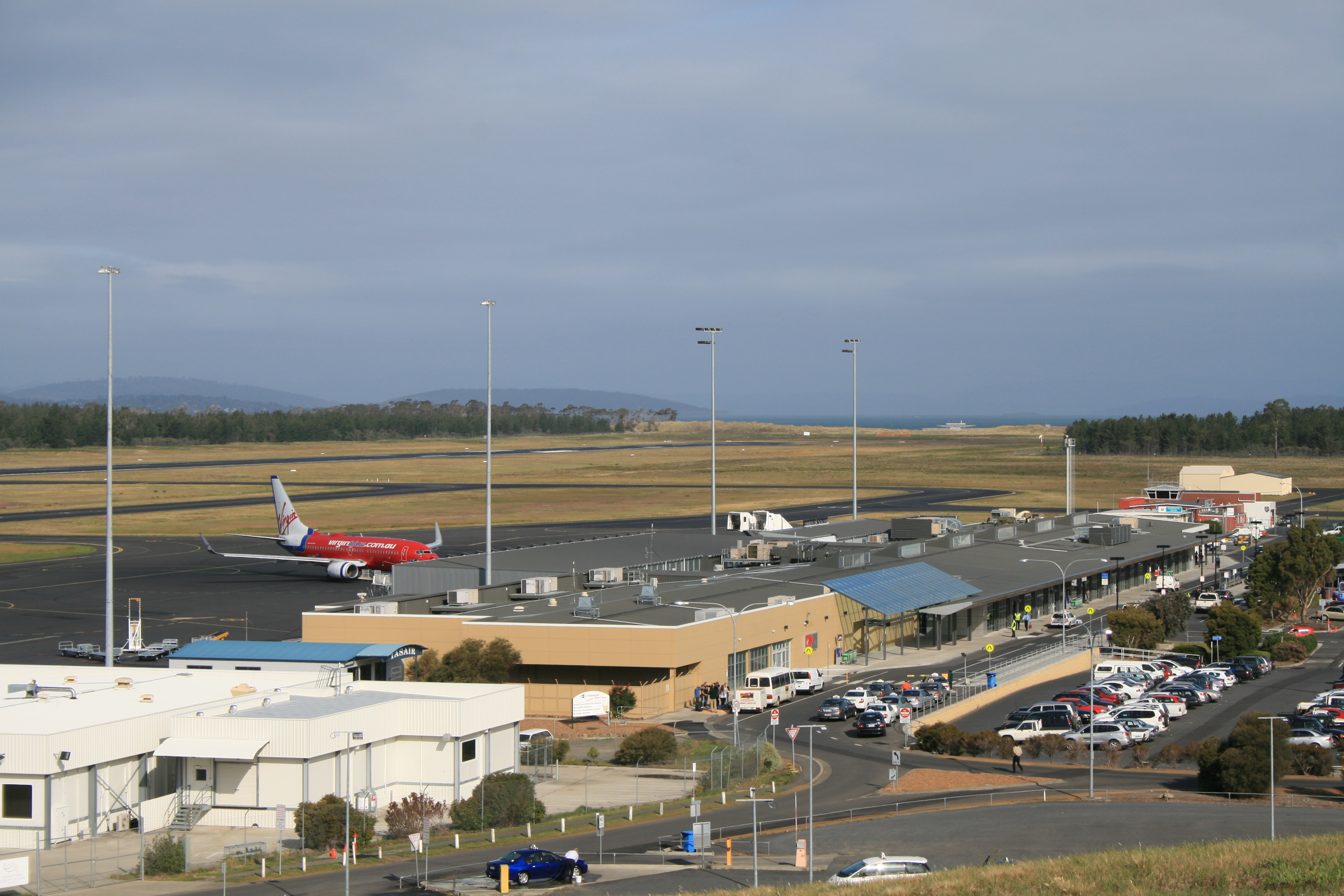
Tasmania's main air carriers are Jetstar and Virgin Australia; Qantas, QantasLink and Rex Airlines. These airlines fly direct routes to Brisbane, Gold Coast, Melbourne and Sydney. Major airports include Hobart Airport and Launceston Airport; the smaller airports, Burnie (Wynyard) and King Island, serviced by Rex Airlines; and Devonport, serviced by QantasLink; have services to Melbourne. Intra-Tasmanian air services are offered by Airlines of Tasmania. Until 2001 Ansett Australia operated majorly out of Tasmania to 12 destinations nationwide. Tourism-related air travel is also represented in Tasmania, such as in the Par Avion route between Cambridge Aerodrome near Hobart to Melaleuca in Southwest National Park.
Antarctica base
Tasmania – Hobart in particular – serves as Australia's chief sea link to Antarctica, with the Australian Antarctic Division located in Kingston. Hobart is also the home port of the French ship l'Astrolabe, which makes regular supply runs to the French Southern Territories near and in Antarctica.
Road

Within the state, the primary form of transport is by road. Since the 1980s, many of the state's highways have undergone regular upgrades. These include the Hobart Southern Outlet, Launceston Southern Outlet, Bass Highway reconstruction, and the Huon Highway. Public transport is provided by Metro Tasmania bus services, regular taxis and Hobart only[194] UBER ride-share services within urban areas, with Redline Coaches, Tassielink Transit and Callows Coaches providing bus service between population centres.

Rail
Rail transport in Tasmania consists of narrow-gauge lines to all four major population centres and to mining and forestry operations on the west coast and in the northwest. Services are operated by TasRail. Regular passenger train services in the state ceased in 1977; the only scheduled trains are for freight, but there are tourist trains in specific areas, for example the West Coast Wilderness Railway. There is an ongoing proposal to reinstate commuter trains to Hobart. This idea however lacks political motivation.
Shipping

The port of Hobart is the second deepest natural port in the world, second to only Rio de Janeiro in Brazil.[citation needed] There is a substantial amount of commercial and recreational shipping within the harbour, and the port hosts approximately 120 cruise ships during the warmer half of the year, and there are occasional visits from military vessels.[195]
Burnie and Devonport on the northwest coast host ports and several other coastal towns host either small fishing ports or substantial marinas. The domestic sea route between Tasmania and the mainland is serviced by Bass Strait passenger/vehicle ferries operated by the Tasmanian government-owned TT-Line. The state is also home to Incat, a manufacturer of very high-speed aluminium catamarans that regularly broke records when they were first launched. The state government tried using them on the Bass Strait run but eventually decided to discontinue the run because of concerns over viability and the suitability of the vessels for the extreme weather conditions sometimes experienced in the strait.[citation needed]
Gallery
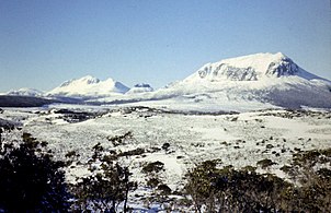
 Hobart from kunanyi / Mount Wellington

 92-metre-high Eucalyptus regnans
 Temperate rainforest
 Lake Pedder and Mount Anne from Western Arthurs
 Cradle Mountain from the shore of Dove Lake
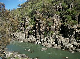 Cataract Gorge, Launceston
 Sub-Antarctic Garden, Royal Tasmanian Botanical Gardens, Hobart


See also
- Index of Australia-related articles
- List of amphibians of Tasmania
- List of schools in Tasmania
- Omission of Tasmania from maps of Australia
- Outline of Australia
- Regions of Tasmania
Notes
- In accordance with the Australian Bureau of Statistics source, England, Scotland, Mainland China and the Special Administrative Regions of Hong Kong and Macau are listed separately
- As a percentage of 475,884 persons who nominated their ancestry at the 2016 census.
- The Australian Bureau of Statistics has stated that most who nominate "Australian" as their ancestry are part of the Anglo-Celtic group.[130]
- Of any ancestry. Includes those identifying as Aboriginal Australians or Torres Strait Islanders. Indigenous identification is separate to the ancestry question on the Australian Census and persons identifying as Aboriginal or Torres Strait Islander may identify any ancestry.
- Of any ancestry. Includes those identifying as Aboriginal Australians or Torres Strait Islanders. Indigenous identification is separate to the ancestry question on the Australian Census and persons identifying as Aboriginal or Torres Strait Islander may identify any ancestry.
References
- "Tasmanian Aboriginal Centre – Official Aboriginal and Dual Names of places". Tacinc.com.au. 28 July 2022. Retrieved 2 August 2022.
- "Taswegian". Lexico OED. Archived from the original on 3 September 2021. Retrieved 3 September 2021.
- "Vandemonian". Lexico OED. Archived from the original on 20 January 2021. Retrieved 5 September 2021.
- "National, state and territory population – December 2021". Australian Bureau of Statistics. 28 June 2022. Archived from the original on 18 September 2021. Retrieved 28 June 2022.
- "5220.0 – Australian National Accounts: State Accounts, 2019–20". Australian Bureau of Statistics. 20 November 2020. Retrieved 20 January 2021.
- "6524.0.55.002 – Estimates of Personal Income for Small Areas, 2011–2016". Australian Bureau of Statistics. Australian Government. 19 June 2018. Retrieved 5 September 2021.
- "Sub-national HDI". Global Data Lab. Retrieved 3 September 2021.
- "Proclamation of Tasmanian Devil as Tasmania's Animal Emblem" (PDF). www.parliament.tas.gov.au. 25 May 2015. Retrieved 2 June 2015.
- "Tasmanian State Emblems". parliament.tas.gov.au. Parliament of Tasmania. Retrieved 1 June 2015.
- "Proclamation of Tasmanian floral emblem". Tasmanian Government Gazette. www.parliament.tas.gov.au. 27 November 1962. Retrieved 23 January 2013.
- Gray, Alan M. "Eucryphia lucida – Leatherwood". Australian Native Plants Society. Retrieved 5 September 2021.
- "Proclamation of Tasmanian mineral emblem". Tasmanian Government Gazette. www.parliament.tas.gov.au. 4 December 2000. Retrieved 23 January 2013.
- "Sporting colours". Department of Premier and Cabinet. Tasmanian Government. Retrieved 5 September 2021.
- "Tasmanian Aboriginal Centre – Official Aboriginal and Dual Names of places". tacinc.com.au. Retrieved 26 May 2022.
- "Tasmania". Oxford Advanced Learner's Dictionary. Retrieved 7 May 2021.
- "Islands". Geoscience Australia. 15 May 2014. Retrieved 14 May 2021.
- "3218.0 – Regional Population Growth, Australia, 2016–17: Main Features". Australian Bureau of Statistics. 24 April 2018. Retrieved 13 October 2018. Estimated resident population, 30 June 2017.
- "Aboriginal Life Pre-Invasion". www.utas.edu.au. Retrieved 3 September 2018.
- "Separation of Tasmania". Canberra: National Museum Australia. Retrieved 22 July 2020.
- Frank Bolt, The Founding of Hobart 1803–1804, ISBN 0-9757166-0-3
- "Van Diemens Land". Encyclopædia Britannica. Retrieved 3 September 2018.
- "Convicts and the British colonies in Australia". Commonwealth of Australia. Archived from the original on 1 January 2016. Retrieved 31 December 2015.
- "Estimated full time employment | Tasmania | economy.id". economy.id.com.au. State Growth Tasmania.
- "Complete National Parks and Reserves Listings". Parks and Wildlife Service. 29 January 2014. Retrieved 7 May 2021.
- Howes, Michael. "United Tasmania Group (UTG)". Encyclopædia Britannica. Retrieved 21 January 2015.
- Newman, Terry (2005). "Appendix 2: Select chronology of renaming". Becoming Tasmania – Companion Web Site. Parliament of Tasmania. Archived from the original on 22 April 2011. Retrieved 26 August 2011.
- "Tasmanian Aboriginal place names". Tasmanian Aboriginal Centre. Retrieved 30 November 2019.
- "Aboriginal and Dual Names of places in lutruwita (Tasmania)". Tasmanian Aboriginal Centre. Retrieved 30 November 2019.
- "Tasmanian Aboriginal Centre – Official Aboriginal and Dual Names of places". tacinc.com.au.
- "archaeology". 15 November 2010. Archived from the original on 15 November 2010.
- "QUIRKY PLACE NAMES OF TASMANIA". Discover Tasmania. Retrieved 31 August 2021.
- Ryan, Lyndall (2012), Tasmanian Aborigines, Sydney: Allen & Unwin, pp. 3–6, ISBN 978-1-74237-068-2
- Ryan, Lyndall (2012), Tasmanian Aborigines, Sydney: Allen & Unwin, pp. 4, 43, ISBN 978-1-74237-068-2
- Clements, Nicholas (2013), Frontier Conflict in Van Diemen's Land (PhD thesis) (PDF), University of Tasmania, pp. 324, 325
- Hughes, Robert (1987), The Fatal Shore, London: Pan, pp. 120–125, ISBN 978-0-330-29892-6
- Boyce, James (2010), Van Diemen's Land, Melbourne: Black Inc, p. 15, ISBN 978-1-86395-491-4
- Boyce, James (2010), Van Diemen's Land, Melbourne: Black Inc, p. 21, ISBN 978-1-86395-491-4
- Ryan, Lyndall (2012), Tasmanian Aborigines, Sydney: Allen & Unwin, pp. 54–57, 71, ISBN 978-1-74237-068-2
- Boyce, James (2010), Van Diemen's Land, Melbourne: Black Inc, pp. 140, 145, 202, ISBN 978-1-86395-491-4
- The Fate Of The Aboriginal Inhabitants (Sydney Morning Herald, 21 Feb 1867, p.8)
- Clements, Nicholas (24 April 2014). "Tasmania's Black War: a tragic case of lest we remember?". Honorary Research Associate, University of Tasmania. The Conversation. Retrieved 27 October 2016.
- The Editors of Encyclopædia Britannica. "Black War – Australian History". The Editors of Encyclopædia Britannica. Chatswood, NSW 2067, Australia: Encyclopædia Britannica. Retrieved 27 October 2016.
{{cite encyclopedia}}:|author=has generic name (help)CS1 maint: location (link) - Clements, Nicholas (2014), The Black War, Brisbane: University of Queensland Press, p. 36, ISBN 978-0-70225-006-4
- Ryan, Lyndall (2012), Tasmanian Aborigines, Sydney: Allen & Unwin, pp. 58, 62, 66, 74–75, ISBN 978-1-74237-068-2
- The Black War (The Cornwall Chronicle, Launceston: 8 Sep, 1860, p.3)
- The Black Natives (Hobart Town Gazette, 11 Nov 1926, p.2)
- Clements, Nicholas (2014), The Black War, Brisbane: University of Queensland Press, pp. 20, 49, ISBN 978-0-70225-006-4
- Ryan, Lyndall (2012), Tasmanian Aborigines, Sydney: Allen & Unwin, pp. 93–100, ISBN 978-1-74237-068-2
- Dr Khadija von Zinnenburg Carroll (28 April 2014). Art in the Time of Colony. Ashgate Publishing, Ltd. pp. 92–. ISBN 978-1-4094-5596-7.
- Sharon Morgan (11 December 2003). Land Settlement in Early Tasmania: Creating an Antipodean England. Cambridge University Press. pp. 151–. ISBN 978-0-521-52296-0.
- Ryan, Lyndall (2012), Tasmanian Aborigines, Sydney: Allen & Unwin, pp. 101–105, 123, ISBN 978-1-74237-068-2
- Clements, Nicholas (2014), The Black War, Brisbane: University of Queensland Press, pp. 95–101, ISBN 978-0-70225-006-4
- Reynolds, Henry (2013). The Forgotten War. UNSW Australia. p. 63. ISBN 9781742233925.
- Ryan, Lyndall (2012), Tasmanian Aborigines, Sydney: Allen & Unwin, pp. 1199–216, ISBN 978-1-74237-068-2
- Clements, Nicholas (2013), Frontier Conflict in Van Diemen's Land (PhD thesis) (PDF), University of Tasmania, pp. 329–331
- Boyce, James (2010), Van Diemen's Land, Melbourne: Black Inc, p. 296, ISBN 978-1-86395-491-4
- Ryan, Lyndall (2012), Tasmanian Aborigines, Sydney: Allen & Unwin, pp. xix, 215, ISBN 978-1-74237-068-2
- Broome, Richard (2019). Aboriginal Australians (Fifth ed.). Crows Nest: Allen and Unwin. p. 44. ISBN 9781760528218.
- Clements, Nicholas (2013). pp. 110–12
- Boyce, James (2010), Van Diemen's Land, Melbourne: Black Inc, pp. 264, 296, ISBN 978-1-86395-491-4
- Clements, Nicholas (2013). pp. 264–65
- Flood, Josephine (2019). The Original Australians, the story of the Aboriginal people. Crows Nest: Allen and Unwin. p. 107. ISBN 9781760527075.
- Boyce, James (2010), Van Diemen's Land, Melbourne: Black Inc, pp. 1, 158, ISBN 978-1-86395-491-4
- Museum of Australian Democracy. "Constitution Act 1855 (Tas)". Documenting Democracy. Retrieved 25 July 2021.
- Moyle, Helen (February 2020). Australia's fertility transition : a study of 19th-century Tasmania. Canberra: ANU Press. p. 49. ISBN 9781760463366. JSTOR j.ctvxrpxqd. Retrieved 27 July 2020.
- Turnbull, Paul. "Urbanisation – Cultural Artefact – Companion to Tasmanian History". www.utas.edu.au. Retrieved 27 July 2020.
- "Green Politics". www.utas.edu.au. Retrieved 7 June 2021.
- "MONA takes top billing Trips – The Mercury – The Voice of Tasmania". 1 May 2012. Archived from the original on 1 May 2012. Retrieved 10 January 2022.
- Ting, Inga; Scott, Nathanael; Workman, Michael; Hutcheon, Stephen (6 September 2021). "Charting the COVID-19 spread in Australia". ABC News.
- "Public Health Emergency for Tasmania declared". TAS Department of Health. Retrieved 1 September 2021.
- "Australia's COVID-19 vaccine rollout". AUS Department of Health. 12 April 2021. Retrieved 1 September 2021.
- Ridge, Justin. "Mt. Ossa, Tasmania". The Interactive Tour of Tasmania. Retrieved 26 August 2011.
- "The Tarkine". Retrieved 1 June 2021.
- "Australia's bioregions (IBRA)". Department of Sustainability, Environment, Water, Population and Communities. Commonwealth of Australia. 2012. Retrieved 1 September 2021.
- "Mystery still surrounds origin of iconic button grass plains". University of Tasmania. Retrieved 5 September 2021.
- Jones, M. C. (2003). "Climatology of cold outbreaks with snow over Tasmania". Australian Meteorology Magazine. 3 (52): 157–169. CiteSeerX 10.1.1.223.253. Retrieved 4 September 2021.
- "BUREAU OF BIODIVERSITY AWARENESSFEATURE ARTICLEISSUE ONEMAGAZINE The Last Deciduous Tree in Tasmania". Tasmanian Geographic. August 2013. Retrieved 4 September 2021.
- "Russell Falls". Waterfalls of Tasmania. Retrieved 4 September 2021.
- "Ocean Beach". West Coast Tasmania. Retrieved 4 September 2021.
- "Nothofagus cunninghamii – Hook.&Oerst". Plants For a Future (PFAF). Retrieved 4 September 2021.
- Schilder, Günter (1976). Australia unveiled : the share of the Dutch navigators in the discovery of Australia. Amsterdam: Theatrum Orbis Terrarum Ltd. p. 170. ISBN 978-9022199978.
- Valentyn, Francois (1724–1726). Oud en nieuw Oost-Indien. Dordrecht: J. van Braam. p. vol.3, p.47. ISBN 9789051942347.
- Cameron-Ash, M. (2018). Lying for the Admiralty. Sydney: Rosenberg. p. 105. ISBN 9780648043966.
- Cook, James (19 April 1770). "Cook's Journal: Daily Entries". National Library of Australia, South Seas Collection. Retrieved 18 October 2020.
- Flinders, Matthew (1814). A Voyage to Terra Australis.
- Blainey, Geoffrey (1966). Tyranny of Distance: How Distance Shaped Australia's History. Melbourne: Sun Books. pp. 73–74.
- Discover Tasmania. "Climate and weather". Writer for Discover Tasmania. Tasmania, Australia: Discover Tasmania. Retrieved 27 October 2016.
- "Climate of Launceston". Australian BOM. Archived from the original on 22 February 2009. Retrieved 1 January 2009.
- "Hobart Climate Statistics". Australian Government Bureau of Meteorology. Retrieved 1 January 2009.
- "Launceston Climate Statistics". Australian Government Bureau of Meteorology. Retrieved 14 May 2021.
- "Devonport Climate Statistics". Australian Government Bureau of Meteorology. Retrieved 14 May 2021.
- "Strahan Climate Statistics". Australian Government Bureau of Meteorology. Retrieved 1 January 2009.
- "Climate Statistics: Hobart (Ellerslie Road 1991–2020 normals)". Bureau of Meteorology. Retrieved 30 June 2017.
- "Climate statistics: Hobart (Ellerslie Road)". Bureau of Meteorology. Retrieved 30 June 2017.
- "Highest Temperature – 094029". Bureau of Meteorology. Retrieved 22 November 2017.
- "Lowest Temperature – 094029". Bureau of Meteorology. Retrieved 22 November 2017.
- "Climate statistics: Hobart Airport". Bureau of Meteorology. Retrieved 21 October 2017.
- "Climate Statistics for Launceston". Bureau of Meteorology. Retrieved 28 October 2017.
- "Climate Statistics for Launceston". Australian Government. Bureau of Meteorology. Retrieved 5 November 2016.
- "Climate Statistics for Launceston". Australian Government. Bureau of Meteorology. Retrieved 5 November 2016.
- "Apple Industry". Retrieved 14 May 2021.
- "Why don't we have more native deciduous trees in Australia?". ABC News. 6 March 2016. Retrieved 10 January 2022.
- "Tall tree Centurion passes 100-metre mark, creating milestone for Tasmanian wilderness". Australian Broadcasting Corporation. 11 December 2018. Retrieved 31 August 2021.
- "Athrotaxis". Trees and Shrubs Online. Retrieved 31 August 2021.
- "Leatherwood Honey". Slow Food Foundation. Retrieved 31 August 2021.
- "Edible Plants of Tasmania" (PDF). National Landcare Programme, NRM North. Australian Government. Retrieved 4 September 2021.
- "Platypus in Tasmania". DPIPWE. Retrieved 2 September 2021.
- Boyce, James, 'The social and Environmental impact of the introduction of the dog to Tasmania' in Environmental History Vol. 11, No. 1 (Jan. 2006), pp. 102–129
- "Saving the Swift Parrot". Australian National University. Retrieved 31 August 2021.
- "Birds". DPIPWE. Tasmanian Government. Retrieved 2 September 2021.
- "Fungi – overlooked beauties". Gardens for Wildlife, DPIPWE. Retrieved 31 August 2021.
- "Fact check: Does Australia have one of the 'highest loss of species anywhere in the world'? (CORRECT)". ABC News. 19 August 2015. Retrieved 4 September 2021.
- "Extinct Tasmanian Species". Our Tasmania. Retrieved 4 September 2021.
- "Threatened Species List – Vertebrate Animals". DPIPWE. Tasmanian Government. Retrieved 4 September 2021.
- "Welcome to Tasmania, the roadkill capital of the world". Australian Broadcasting Corporation. 14 December 2015. Retrieved 4 September 2021.
- "1362.6 – Regional Statistics, Tasmania, 2007". Australian Bureau of Statistics. 6 February 2006. Retrieved 4 September 2021.
- "Tasmanian Wilderness World Heritage Area (TWWHA)". Tasmania Parks & Wildlife Service. Retrieved 4 September 2021.
- "UNESCO rejects Coalition's bid to delist Tasmanian World Heritage forest". Australian Broadcasting Corporation. 24 June 2014. Retrieved 4 September 2021.
- "The Tarkine National Heritage assessment". Department of Agriculture. Australian Governmennt. Retrieved 4 September 2021.
- Loynes, Kate. "The Tarkine: more than just a forest?". Parliament of Australia. Retrieved 4 September 2021.
- "Tasmania | History, Capital, Map, Climate, & Facts | Britannica". www.britannica.com. Retrieved 10 January 2022.
- "Australia had baby boom in 2007: ABS". The Age. Australia. Retrieved 2 April 2010.
- "Birth-rate slump in Tasmania linked with tough economic times for families". The Mercury. 4 November 2013. Archived from the original on 31 March 2014. Retrieved 31 March 2014.
- "Kingston, TAS". Aussie Towns. Retrieved 28 May 2019.
- "Largest cities by population in Tasmania". Bonzle. Retrieved 6 September 2021.
- "Hobart Population 2021". Population Australia. Retrieved 6 September 2021.
- "3218.0 – Regional Population Growth, Australia, 2016–17: Population Estimates by Significant Urban Area, 2007 to 2017". Australian Bureau of Statistics. Australian Bureau of Statistics. 24 April 2018. Retrieved 12 October 2018. Estimated resident population, 30 June 2017.
- "2016 Census Community Profiles: Tasmania". quickstats.censusdata.abs.gov.au.
- "Census 2016". Retrieved 26 June 2020.
- Statistics, c=AU; o=Commonwealth of Australia; ou=Australian Bureau of (January 1995). "Feature Article – Ethnic and Cultural Diversity in Australia (Feature Article)". www.abs.gov.au.
- "Snapshot of Tasmania". Archived from the original on 16 July 2022. Retrieved 16 July 2022.
- "Tasmanian Liberals secure 15 seats as election count ends". Australian Broadcasting Corporation. 27 March 2014. Retrieved 1 May 2014.
- "Gutwein premier, Rockliff deputy, after Tasmanian Liberal rivals quit contest". ABC News. 20 January 2020. Retrieved 20 January 2020.
- "Tasmania Election 2021". Australian Broadcasting Corporation. Retrieved 1 September 2021.
- Press, Australian Associated (8 April 2022). "Jeremy Rockliff becomes Tasmania's 47th premier after being elected as state Liberal leader". the Guardian. Retrieved 26 September 2022.
- Davies, Lynn (2006). "Lake Pedder". Centre for Tasmanian Historical Studies. Retrieved 6 March 2010.
- Baker, Emily (25 February 2020). "Tasmanian Lower House should be increased by 10 members, report recommends". ABC News. Retrieved 1 September 2021.
- "HOUSE OF ASSEMBLY SELECT COMMITTEE ON THE HOUSE OF ASSEMBLY RESTORATION BILL Final Report" (PDF). Parliament of Tasmania. Retrieved 1 September 2021.
- "Local Government Elections Tasmania". www.tec.tas.gov.au. Retrieved 29 April 2022.
- Inc, IBP (16 December 2016). Australia Business and Investment Opportunities Yearbook Volume 8 Tasmania Mining and Minerals. Lulu.com. ISBN 978-1-4387-8388-8.
- "Industry Info page". Fruit Growers Tasmania. Archived from the original on 21 August 2011. Retrieved 26 August 2011.
- Eslaka, Saul (August 2011). Local Government and Southern Tasmanian Economy.
- "Major employers campaign to boost their public profile". The Mercury. 22 November 2013. Archived from the original on 10 April 2015. Retrieved 4 April 2015.
- Hingst, Raymond D. (2004). "Call centres, recent history – where have they come from and how did they get here?". Proceedings of the 2nd National Call Centre Research Conference. Melbourne, Australia: Monash University, Institute for Regional Studies.
- Denholm, Matthew (9 April 2011). "Clean, green and leaning on the mainland". The Australian. Sydney, Australia. Retrieved 26 August 2011.
- Hanrahan, Danielle. "11 best places to retire in Australia". oversixty.com.
- "Tasmania Output". economy.id. Retrieved 1 September 2021.
- "Tasmania Employment by industry (Total)". economy.id. Retrieved 1 September 2021.
- "Science research". Department of State Growth. Tasmanian Government. Retrieved 2 September 2021.
- "Tasmanian Creativity". University of Tasmania. Retrieved 2 September 2021.
- Gantevoort, Michelle; Hamacher, Duane W.; Lischick, Savannah (December 2016). "Reconstructing the Star Knowledge of Aboriginal Tasmanians" (PDF). Journal of Astronomical History and Heritage. 19 (3): 327–347. arXiv:1610.02785. Bibcode:2016JAHH...19..327G. Retrieved 2 September 2021.
- "National Heritage Places – Recherche Bay (North East Peninsula) Area". Department of Agriculture, Water and Environment. Australian Governmennt. Retrieved 2 September 2021.
- "Royal Society of Tasmania (1843 – )". Encyclopedia of Australian Science. Retrieved 2 September 2021.
- "Tasmanian Natural History Society (1838–1849)". Encyclopedia of Australian Science. Retrieved 2 September 2021.
- "How Tamworth beat the big smoke and became the first city of light". Australian Broadcasting Corporation. Retrieved 2 September 2021.
- "Waratah, Tasmania". OurTasmania. Retrieved 2 September 2021.
- "Subscribe to The Australian | Newspaper home delivery, website, iPad, iPhone & Android apps". myaccount.news.com.au.
- "Heather Rose wins the Stella Prize". abc.net.au. 19 April 2017.
- "Katherine Scholes". www.penguin.com.au.
- Leary, Rachel. "Bridget Crack – Rachel Leary – 9781760295479 – Allen & Unwin – Australia". www.allenandunwin.com.
- "Angelica Banks – Allen & Unwin – Australia". www.allenandunwin.com.
- Turner, Ellen (2019). ""The Whole Island is a Jail and We the Warders": States of Exception in Tasmanian Historical Fiction". Commonwealth Essays and Studies. 42 (1). doi:10.4000/ces.1076. S2CID 186592980.
- "MONA puts Tassie on map Tasmania News – The Mercury – The Voice of Tasmania". 14 May 2011. Archived from the original on 14 May 2011. Retrieved 10 January 2022.
- Shock of the old and new, The Sydney Morning Herald, 10 January 2011.
- "Psycroptic: Rise Above". themetalforge.com. Retrieved 6 March 2010.
- "Beathoven and The Innocents – Official Web site". theinnocents.com.au. The Innocents. Retrieved 2 April 2010.
- "Fanny Cochrane Smith's Tasmanian Aboriginal songs and language preserved forever". ABC News. 9 February 2017. Retrieved 5 September 2021.
- Longman, Murray J. (1960). "SONGS OF THE TASMANIAN ABORIGINES AS RECORDED BY MRS. FANNY COCHRANE SMITH" (PDF). Papers and Proceedings of the Royal Society of Tasmania. 94. Retrieved 5 September 2021.
- "Kitty Parker". Australian Composers. Wirripang. Retrieved 5 September 2021.
- "The life, love and legacy of Peter Sculthorpe (1929–2014)". Australian Broadcasting Corporation. Retrieved 5 September 2021.
- "Port Arthur: In Memoriam". Faber Music. Retrieved 5 September 2021.
- Sherwin, Frances Amy Lillian (1855–1935). Australian Dictionary of Biography. Retrieved 5 September 2021.
- Tunley, David. Joyce, Eileen Alannah (1908–1991). Australian Dictionary of Biography (ADB). Retrieved 18 September 2021.
- "Tough legacy of a Sydney classic". BBC News. 29 December 2001. Retrieved 12 August 2016.
- Williams, Claudia (16 July 2020). "NBL launches campaign to name new Tasmanian team". The Advocate. Retrieved 20 September 2021.
- "Your Team is Coming". nbltas.com.au. Retrieved 20 September 2021.
- "Tasmania Tours, Vacation Packages & Travel Experiences". Goway Travel. Retrieved 10 January 2022.
- A traditional Tasmanian Aboriginal Diet. Department of Education, Tasmania. 2018. Retrieved 11 September 2021.
- "Favouring curry a long-time Tasmanian trait". www.abc.net.au. ABC. 23 March 2018. Retrieved 11 September 2021.
- "Top ten Tasmanian food specialities". www.tasmaniatopten.com.
- McLeod, E. A. Irvine, Alice Christina (1879–1940). Australian Dictionary of Biography (ADB). National Centre of Biography, Australian National University. Retrieved 18 September 2021.
- Moran, Jessica (24 May 2020). "Coronavirus restrictions see 1930's Central Cookery Book become a bestseller". Australian Broadcasting Corporation. Retrieved 18 September 2021.
- Baker-Dowdell, Johanna (12 March 2019). "Sheep why vodka wins top Australia award for third year in a row". The Examiner. Retrieved 18 September 2021.
- "Home". Cygnet Folk Festival. Retrieved 5 September 2021.
- "Home". The Unconformity. Retrieved 5 September 2021.
- "The Unconformity". Discover Tasmania. Retrieved 5 September 2021.
- "What is the National Penny Farthing Championship?". Evandale Tasmania. Retrieved 5 September 2021.
- Spears, Fran (15 August 2020). "'From incredible scenery to friendly locals: Tasmania is unlike anywhere else'". startsat60. Retrieved 11 October 2021.
- Hollie, Pamela G. (26 November 1982). "TASMANIANS WEARY OF BEING THE BUTT OF JOKES". The New York Times. Retrieved 13 October 2021.
- Cooper, Erin (13 June 2019). "What is the origin of the joke about Tasmanians having two heads?". Australian Broadcasting Corporation. Retrieved 1 October 2021.
- "Motivations Research – Appeal triggers and motivations for tourism in Tasmania, March 2011" (PDF). Tourism Tasmania. Tasmanian Government. Retrieved 11 October 2021.
- "Cessation of Transportation". Female Convicts Research Centre Inc. Retrieved 11 October 2021.
- Alexander, Alison. "TASMANIA'S REPUTATION". (UTAS) The Companion to Tasmanian History. University of Tasmania. Retrieved 1 October 2021.
- "Drive or Ride with Uber in Hobart | Uber". www.uber.com.
- Rockliff, Jeremy. "TasPorts continues to deliver strong results". Premier of Tasmania. Retrieved 24 December 2019.
Further reading
- Fenton, James (1884). A History of Tasmania From Its Discovery in 1642 to the Present Time (PDF). Launceston, Tasmania: Launceston Examiner.
- Alexander, Alison, ed. (2005). The Companion to Tasmanian History. Hobart, Tasmania: Centre for Tasmanian Historical Studies, University of Tasmania. ISBN 978-1-86295-223-2. OCLC 61888464.
- Robson, L. L. (1983). A History of Tasmania. Vol. 1. Van Diemen's Land from the Earliest Times to 1855. Melbourne: Oxford University Press. ISBN 0-19-554364-5.
- Robson, L. L. (1991). A History of Tasmania. Vol. 2. Colony and State from 1856 to the 1980s. Melbourne: Oxford University Press. ISBN 0-19-553031-4.
- Cameron-Ash, Margaret (2018). Lying for the Admiralty. Captain Cook's first voyage & secret of Port Jackson. Kenthurst, New South Wales: Rosenberg. ISBN 978-0-648-04396-6.
External links
- Tasmania Online—the main State Government website
- Discover Tasmania – official tourism website
 Geographic data related to Tasmania at OpenStreetMap
| General |
| |
|---|---|---|
| Regions |
| |
| Cities | ||
States and territories of Australia | |||||||||
|---|---|---|---|---|---|---|---|---|---|
| States |
|  | |||||||
| Territories |
| ||||||||
(1) Sovereignty recognised only by France, New Zealand, Norway, and the United Kingdom. (2) Co-mandate with New Zealand and the United Kingdom. | |||||||||
Authority control | |
|---|---|
| General | |
| National libraries | |
| Other |
|
На других языках
[de] Tasmanien
Tasmanien (englisch Tasmania, in der rekonstruierten Aborigines-Sprache palawa kani lutruwita[2][3] und im australischen Englisch häufig Tassie; bis Ende 1855[4][5] Van-Diemens-Land) ist eine zum Staat Australien gehörende Insel am östlichen Rand des Indischen Ozeans. Sie ist ungefähr 240 km südlich der australischen Kontinentalmasse vorgelagert. Tasmanien heißt auch der australische Bundesstaat, der über die Hauptinsel Tasmanien hinaus noch mehrere kleine, meist unbewohnte Inselgruppen in der Region umfasst. Seine Hauptstadt und größte Stadt ist Hobart, die zweitgrößte Stadt Launceston.- [en] Tasmania
[ru] Тасмания
Тасма́ния (англ. Tasmania, палава-кани lutruwita) — австралийский штат, который расположен на одноимённом острове в 240 км к югу от материка Австралии, отделённом от континента проливом Басса. Администрация также распространяется на ближайшие острова (Кинг, Флиндерс и др.) и отдалённый остров Маккуори. Население — 534 457 человек[2] (2020 г., оц.). Площадь — 68 401 км². Столица и крупнейший город — Хобарт[4]. Другие крупные города — Лонсестон, Девонпорт и Берни.Другой контент может иметь иную лицензию. Перед использованием материалов сайта WikiSort.org внимательно изучите правила лицензирования конкретных элементов наполнения сайта.
WikiSort.org - проект по пересортировке и дополнению контента Википедии