geo.wikisort.org - Mountains
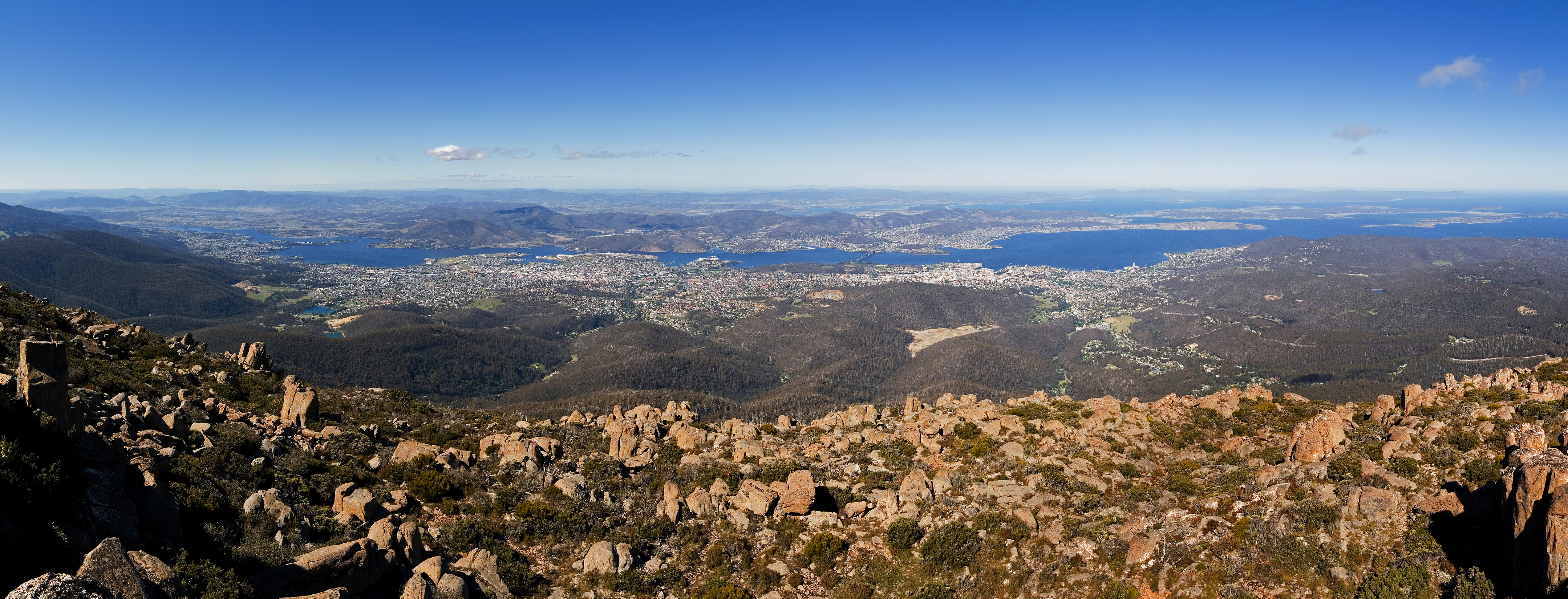
Mount Wellington (officially kunanyi / Mount Wellington (/kuːˈnɑːniː/)[3]) is a mountain in the southeast of Tasmania, Australia. It is the summit of the Wellington Range and is within Wellington Park reserve. Hobart, Tasmania's capital city, is located at the foot of the mountain.
| Mount Wellington | |
|---|---|
| kunanyi / Mount Wellington | |
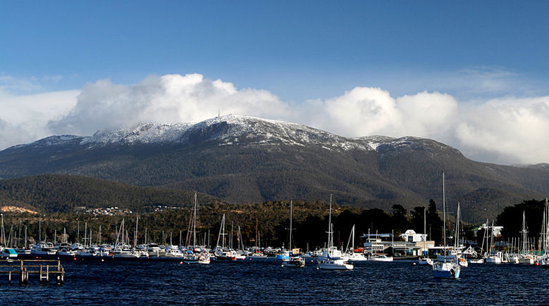 Mount Wellington viewed from Lindisfarne Bay on the Eastern Shore of the River Derwent | |
| Highest point | |
| Elevation | 1,271 m (4,170 ft)[1] |
| Prominence | 693 m (2,274 ft)[1] |
| Isolation | 47.56 km (29.55 mi)[1] |
| Listing | 49th highest mountain of Tasmania |
| Coordinates | 42°53′45.6″S 147°14′14.3″E[2] |
| Geography | |
 Mount Wellington Location in Tasmania | |
| Location | South East Tasmania, Australia |
| Parent range | Wellington |
| Geology | |
| Mountain type | Dolerite |
| Climbing | |
| First ascent |
|
| Easiest route | Hike, road |
The mountain rises to 1,271 metres (4,170 ft) above sea level[1] and is frequently covered by snow, sometimes even in summer, and the lower slopes are thickly forested, but crisscrossed by many walking tracks and a few fire trails.[4] There is also a sealed narrow road to the summit, about 22 kilometres (14 mi) from Hobart central business district. An enclosed lookout near the summit has views of the city below and to the east, the Derwent estuary, and also glimpses of the World Heritage Area nearly 100 kilometres (62 mi) west. From Hobart, the most distinctive feature of Mount Wellington is the cliff of dolerite columns known as the Organ Pipes.
Geology
The low-lying areas and foothills of Mount Wellington were formed by slow geological upsurge when the whole Hobart area was a low-lying cold shallow seabed. The upper reaches of the mountain were formed more violently, as a Sill with a tabular mass of igneous rock that has been intruded laterally between layers of older rock pushing upwards by upsurges of molten rock as the Australian continental shelf tore away from Antarctica, and separated from Gondwana over 40 million years ago. A small volcanic vent was active about 300m south of the Pinnacle during Tertiary times, between 50 and 10 million years ago.[citation needed]
Indigenous history
The aboriginal nations people of the area referred to Mount Wellington as kunanyi (or ungyhaletta), poorawetter (or pooranetere, also pooranetteri).[5]
The indigenous people of Tasmania referred to it as kunanyi.[citation needed] The Palawa, the surviving descendants of the original indigenous Tasmanians, tend to prefer[clarification needed] the latter name. In 2013, the Tasmanian government announced a dual naming policy and "kunanyi / Mount Wellington" was named as one of the inaugural dual named geographic features.[3][6]
European history
The first recorded European in the area Abel Tasman probably did not see the mountain in 1642, as his ship was quite a distance out to sea as he sailed up the South East coast of the island – coming closer in near present-day North and Marion Bays.[7]
No other Europeans visited Tasmania until the late eighteenth century, when several visited southern Tasmania (then referred to as Van Diemens Land) including Frenchman Marion du Fresne (1772), Englishmen Tobias Furneaux (1773), James Cook (1777) and William Bligh (1788 and 1792), and Frenchman Bruni d'Entrecasteaux (1792–93). In 1793 Commodore John Hayes arrived at the Derwent River, naming the mountain Skiddaw, after the mountain in the Lake District, although this name never gained popularity.[citation needed]
In 1798 Matthew Flinders and George Bass circumnavigated the island. Whilst they were resting in the area Flinders named the river the Derwent River (the name John Hayes had given only to the upper part of the river),[8] Flinders referred to the mountain as 'Table Mountain' (the name given to it by Bond and Bligh – young Matthew Flinders was with them in 1791) for its similarity in appearance to Table Mountain in South Africa. Bruni d'Entrecasteaux's men were the first European to sail up the river and chart it. Later Nicholas Baudin led another French expedition in 1802, and whilst sheltering in the Derwent River (which they referred to as 'River du Nord' – the name d'Entrecasteaux had given to it) Baudin also referred to the mountain as 'Montagne du Plateau' (also named by d'Entrecasteaux). However, the British first settled in the Hobart area in 1804, resulting in Flinders' name of 'Table Mountain' becoming more popular. Table Mountain remained its common name until in 1832 it was decided to rename the mountain in honour of the Duke of Wellington who, with Gebhard Leberecht von Blücher finally defeated Napoleon at the Battle of Waterloo in present-day Belgium on 18 June 1815.[citation needed]

In February 1836, Charles Darwin visited Hobart Town and climbed Mount Wellington. In his book The Voyage of the Beagle, Darwin described the mountain thus:
"... In many parts the Eucalypti grew to a great size, and composed a noble forest. In some of the dampest ravines, tree-ferns flourished in an extraordinary manner; I saw one which must have been at least twenty feet high to the base of the fronds, and was in girth exactly six feet. The fronds forming the most elegant parasols, produced a gloomy shade, like that of the first hour of the night. The summit of the mountain is broad and flat, and is composed of huge angular masses of naked greenstone. Its elevation is 3,100 feet [940 m] above the level of the sea. The day was splendidly clear, and we enjoyed a most extensive view; to the north, the country appeared a mass of wooded mountains, of about the same height with that on which we were standing, and with an equally tame outline: to the south the broken land and water, forming many intricate bays, was mapped with clearness before us. ..."
The first weather station was set up on Mount Wellington in 1895 by Clement Lindley Wragge.
Mount Wellington has played host to some notorious characters over time, especially the bushranger 'Rocky' Whelan, who murdered several travelers in the middle of the 19th century. The cave where he lived is known appropriately as 'Rocky Whelan's Cave', and is an easy walk from the Springs.[9]
Development


Throughout the 19th and into the 20th centuries, the mountain was a popular day-resort for residents of Hobart. To that end, many excursion huts were built over the lower slopes of the mountain. However, none of these early huts survive as they were all destroyed during the disastrous bushfires of 1967, though modern huts are open to the public at the Springs, the Pinnacle, the Chalet – a picnic spot about halfway between the Springs and the Pinnacle – and elsewhere.[10] Sadly, many of the more remote huts have suffered from vandalism, and some are virtually derelict.
The road to the summit was constructed in the early 1930s as a relief scheme for the unemployed, an idea initiated by Albert Ogilvie, the premier of Tasmania of the day. While the road is officially known as the Pinnacle Drive, it was, for some time, also widely known among residents of Hobart as 'Ogilvie's Scar' because at the time it was constructed 'the Mountain' was heavily logged and almost bare, and the road was an all-too-obvious scar across the already denuded mountain. Today the trees have grown again, but the 'scar' most people see today is not actually the road but a line of large rocks with no trees 50–100 m above the road, provided as an easement for power lines. The road itself was opened on 23 January 1937, after two years of work, by Governor Sir Ernest Clark.[11]
The road carries tourist traffic during the day, and sections may be closed at any time of the year due to snowfalls or icy conditions. Halfway up this road (at 720 metres) is a picnic area called "The Springs", near the site of a chalet/health spa that was destroyed by bushfire in 1967.
Broadcast Tower
Mount Wellington was selected by many broadcasters as the site of radio and television transmitters as it provides line-of-sight transmission to a large area of Hobart and surrounding districts. A 60m steel lattice tower was constructed in 1960, surpassing the Taroona Shot Tower as the tallest structure in Tasmania. The first television stations to transmit from the mountain were TVT-6 (now WIN Television) and ABT-2 (the ABC) in 1960. Two main transmission towers located at its pinnacle; the concrete and steel BAI Communications tower (sometimes referred to as the NTA tower) and the other owned by WIN Television, of steel construction. The NTA tower broadcasts all of Hobart's high-power FM radio stations, plus the digital TV services for ABC and SBS. It also has a small accommodation area at its base, with a kitchen and workshop area. The WIN tower broadcasts the digital TV services for Southern Cross, WIN Television, and Tasmanian Digital Television. The site also contains a small kitchen area and contains some data links from local Hobart businesses. An amateur radio repeater is also installed on the mountain.
Erected in 1995, the current broadcast tower stands 130m tall. The site is considered one of the most inhospitable broadcasting sites in Australia with large incidence of strong winds which generally derive from the roaring forties that sweep the Southern Ocean from Africa.[12]


Cable car proposals
- See Mount Wellington cable car proposals
An aerial cableway (cable car) has been proposed for the mountain on four occasions.
Climate
The summit of the mountain has a tundra climate (Koppen ET; Trewartha Fi) according to the standard Köppen–Geiger and Trewartha climate classification systems,[13][14] as a maritime polar climate according to the Australian Bureau of Meteorology classification system.[15] Using Otto Nordenskjöld's alternative polar isotherm,[16] it could be considered to have a subpolar oceanic climate (Köppen Cfc) or a maritime sub(ant)arctic climate (Trewartha Eo), though extreme winds—having been recorded at sustained speeds of over 157 kilometres per hour (98 mph), with rare gusts of up to 200 kilometres per hour (120 mph)—prevent tree cover.
Its record low temperature is −9.1 °C (15.6 °F) recorded on 3 September 1993, extreme for Australia and Tasmania though not especially so, lying outside the top 10 readings and top 7 locations for the state[17] with its exposed, maritime aspect; its average yearly record low of around −6.4 °C (20.5 °F)[18] places it within USDA hardiness zone 9a and Australian National Botanic Gardens hardiness zone 2.[19] It is one of a handful of Australian locations to have never recorded a temperature above 30 °C (86 °F), its highest temperature ever being 29.8 °C (85.6 °F) most recently recorded on 31 January 2020, automatically putting it within American Horticultural Society heat zone 1;[20] the average yearly record high is around 26.4 °C (79.5 °F).[21]
The mountain significantly influences Hobart's weather, and intending visitors to the summit are advised to dress warmly against the often icy winds. In the winter it frequently snows and the mountain is often snowcapped. Lighter snowfalls in spring, summer and autumn are also common. A day on the summit can consist of clear sunny skies, then rain, snow, icy winds and clear again. Only in the months of January and February is it expected that fewer than 3 days will record a frost, and its summit is one of the only locations in Australia to routinely experience sub-freezing daily maxima, with more than 1 in 10 days in both July and August expected to be ice days,[22] and experiencing the coldest daily highs in Tasmanian history at −5.0 °C (23.0 °F) on 5 September 1995 and 11 August 2005.[23]
| Climate data for kunanyi / Mount Wellington (1991–2020 normals, 1961–2021 extremes[note 1]) | |||||||||||||
|---|---|---|---|---|---|---|---|---|---|---|---|---|---|
| Month | Jan | Feb | Mar | Apr | May | Jun | Jul | Aug | Sep | Oct | Nov | Dec | Year |
| Record high °C (°F) | 29.8 (85.6) |
29.6 (85.3) |
28.4 (83.1) |
24.7 (76.5) |
15.0 (59.0) |
13.3 (55.9) |
9.8 (49.6) |
13.4 (56.1) |
19.5 (67.1) |
22.8 (73.0) |
26.2 (79.2) |
28.6 (83.5) |
29.8 (85.6) |
| Average high °C (°F) | 13.9 (57.0) |
13.7 (56.7) |
11.5 (52.7) |
8.5 (47.3) |
6.0 (42.8) |
3.9 (39.0) |
2.7 (36.9) |
3.0 (37.4) |
5.0 (41.0) |
7.5 (45.5) |
10.0 (50.0) |
11.6 (52.9) |
8.1 (46.6) |
| Average low °C (°F) | 5.0 (41.0) |
5.2 (41.4) |
4.1 (39.4) |
2.3 (36.1) |
0.9 (33.6) |
−0.5 (31.1) |
−1.4 (29.5) |
−1.7 (28.9) |
−0.9 (30.4) |
0.2 (32.4) |
2.1 (35.8) |
3.1 (37.6) |
1.5 (34.8) |
| Record low °C (°F) | −3.4 (25.9) |
−7.4 (18.7) |
−4.7 (23.5) |
−6.5 (20.3) |
−8.1 (17.4) |
−7.5 (18.5) |
−8.1 (17.4) |
−7.8 (18.0) |
−9.1 (15.6) |
−7.7 (18.1) |
−6.2 (20.8) |
−4.4 (24.1) |
−9.1 (15.6) |
| Average precipitation mm (inches) | 98.5 (3.88) |
78.4 (3.09) |
84.2 (3.31) |
92.9 (3.66) |
74.1 (2.92) |
97.8 (3.85) |
61.7 (2.43) |
83.7 (3.30) |
80.8 (3.18) |
84.4 (3.32) |
93.6 (3.69) |
91.8 (3.61) |
1,021.9 (40.24) |
| Average precipitation days | 17.6 | 16.9 | 19.4 | 19.4 | 20.3 | 18.6 | 20.6 | 18.7 | 19.7 | 20.3 | 18.3 | 19.8 | 229.6 |
| Average relative humidity (%) (at 15:00) | 74 | 75 | 79 | 83 | 87 | 90 | 93 | 89 | 88 | 83 | 80 | 76 | 83 |
| Source: Bureau of Meteorology[22] | |||||||||||||
See also
Notes
- Temperature was recorded from March 1961 to May 1972 excluding November 1970, then from December 1991 on. Precipitation was recorded from March 1961 to May 1972 and June 1990 to May 1992, then sporadically from 1994 on.
References
- "Mount Wellington, Australia". Peakbagger.com. Retrieved 7 June 2015.
- "Mount Wellington (TAS)". Gazetteer of Australia online. Geoscience Australia, Australian Government.
- "Tasmanian dual naming policy announced atop kunanyi". Australian Broadcasting Corporation. 13 March 2013. Retrieved 20 November 2014.
- "Wellington Park – Bush walking". Retrieved 24 October 2013.
- Milligan, Joseph (1858). "On the dialects and languages of the Aboriginal Tribes of Tasmania, and on their manners and customs". Papers of the Royal Society of Tasmania: 432.
- "kunanyi / Mount Wellington". Hobart City Council. Retrieved 9 June 2015.
- "The curious story of the Dutch explorer who found Tasmania, but missed Australia". The Telegraph. 1 February 2019. Retrieved 4 October 2019.
- Flinders, Matthew (1801). Observations on the coasts of Van Diemen's Land, on Bass's Strait and its islands, and on parts of the coasts of New South Wales; intended to accompany the charts of the late discoveries in those countries. John Nichols. p. 5.
- "Mount Wellington – Rocky Whelan's Cave". Retrieved 24 October 2013.
- "Wellington Park – Sightseeing and facilities". Retrieved 24 October 2013.
- "The Pinnacle Road, Mt Wellington". Australian Bureau of Statistics. 22 January 2013. Retrieved 24 October 2013.
- Cooper, Erin (2 March 2019). "'Most hostile environment of any broadcasting site': Why put a transmission tower on kunanyi/Mount Wellington". Australian Broadcasting Corporation. Retrieved 24 October 2013.
- Beck, Hylke E.; Zimmermann, Niklaus E.; McVicar, Tim R.; Vergopolan, Noemi; Berg, Alexis; Wood, Eric F. (30 October 2018). "Present and future Köppen-Geiger climate classification maps at 1-km resolution". Scientific Data. 5: 180214. Bibcode:2018NatSD...580214B. doi:10.1038/sdata.2018.214. ISSN 2052-4463. PMC 6207062. PMID 30375988.
- Belda, M; Holtanová, E; Halenka, T; Kalvová, J (4 February 2014). "Climate classification revisited: from Köppen to Trewartha" (PDF). Climate Research. 59 (1): 1–13. Bibcode:2014ClRes..59....1B. doi:10.3354/cr01204.
- Stern, Harvey; Hoedt, Graham; Ernst, Jeneanne (June 2000). "Objective classification of Australian climates". Australian Meteorological Magazine. 49 (2): 87–96. Retrieved 27 September 2022.
- Nordenskjöld, Otto; Mecking, Ludwig; Antevs, Ernst; Hale, Marion (1928). "Chapter VI: The Delimitation of the Polar Regions, and the Natural Provinces of the Arctic and Antarctic". In Joerg, W. L. G. (ed.). The Geography of the Polar Regions, Consisting of A General Characterization of Polar Nature. Special Publication. Vol. 8. New York City: American Geographical Society. pp. 72–3. Bib_id 28009518. Retrieved 27 September 2022 – via Internet Archive.
- "Official records (Lowest daily mimimum temperatures) for Tasmania". Daily Extremes. Bureau of Meteorology. 27 September 2022. Retrieved 27 September 2022.
- "Lowest Temperature - 094087 - Bureau of Meteorology". Monthly lowest temperature Kunanyi (Mount Wellington Pinnacle). Bureau of Meteorology. 27 September 2022. Product Code: IDCJAC0008. Retrieved 27 September 2022.
- Dawson, Iain (1991). "Plant Hardiness Zones for Australia". Australian National Botanic Gardens. Archived from the original on 10 December 2010. Retrieved 27 September 2022.
- "AHS Plant Heat Zone Map". American Horticultural Society. Archived from the original on 16 May 2017. Retrieved 27 September 2022.
- "Highest Temperature - 094087 - Bureau of Meteorology". Monthly highest temperature Kunanyi (Mount Wellington Pinnacle). Bureau of Meteorology. 27 September 2022. Product Code: IDCJAC0005. Retrieved 27 September 2022.
- "Kunanyi (Mount Wellington Pinnacle)". Climate statistics for Australian locations. Bureau of Meteorology. 22 September 2022. Retrieved 27 September 2022.
- "Official records (Lowest daily maximum temperatures) for Tasmania". Daily Extremes. Bureau of Meteorology. 27 September 2022. Retrieved 27 September 2022.
Further reading
- 208 Network. (1994) Mt. Wellington – Mountain Park resource management plan and master plan for the Corporation of the City of Hobart : final draft for public comment : Hobart : 208 Network. "The 208 Network is John Hepper, Jerry de Gryse, with assistance from Chris Sharples, Fred and Diana Duncan, Robert Taylor, Hilary du Cros, Lindy Scripps, Greg Hodge".
- Curtis, Winifred M. (Winifred Mary) (n.d.) Forests and flowers of Mount Wellington, Tasmania illustrated by D. Colbron Pearse. [Hobart]: Tasmanian Museum and Art Gallery.
- de Quincey, Elizabeth and Cannon, John (2005) The Companion to Tasmanian History p. 245 – entry "Mount Wellington"
- Hosier, Phoebe (26 April 2020). "'Something's happened up there': Why Aboriginal Tasmanians shun Hobart's mountain top". ABC News.
- Barnes, Angus (1992), 'Mount Wellington and the sense of place', Honours thesis, University of Tasmania. https://eprints.utas.edu.au/31711/
External links
| Buildings and structures: |
|
|---|---|
| Institutions: |
|
| Entertainment: |
|
| Galleries and museums: |
|
| Sports: |
|
| Transport: |
|
| Nature and parks: |
|
| Precincts: |
|
| Beaches and islands: | |
Southern region of Tasmania, Australia | |||||
|---|---|---|---|---|---|
| Settlements |
| ||||
| Governance |
| ||||
| Mountains | |||||
| Protected areas, parks and reserves |
| ||||
| Rivers | |||||
| Harbours, bays, inlets and estuaries |
| ||||
| Coastal features |
| ||||
| Transport |
| ||||
| Landmarks |
| ||||
| Islands | |||||
| Books and newspapers |
| ||||
| Flora, fauna, and fishlife |
| ||||
| Bioregions | |||||
| Indigenous heritage |
| ||||
| Other |
| ||||
| |||||
Authority control | |
|---|---|
| General | |
| National libraries | |
На других языках
[de] Mount Wellington (Tasmanien)
Der Mount Wellington ist der Hausberg von Hobart, der Hauptstadt Tasmaniens.- [en] Mount Wellington (Tasmania)
[fr] Kunanyi/Mont Wellington
Le Kunanyi/mont Wellington (1 271 m), nom officiel depuis 2013, est un sommet de Tasmanie en Australie surplombant la ville de Hobart. Il est très souvent appelé tout simplement « la montagne » (the Mountain en anglais) par les habitants d'Hobart.[it] Monte Wellington
Il monte Wellington è una montagna della Tasmania, in Australia, alle pendici della quale si trova la città di Hobart.[ru] Веллингтон (гора, Тасмания)
Гора́ Ве́ллингтон (англ. Mount Wellington, палава-кани kunanyi) находится на юго-востоке острова (и одноимённого штата Австралии) Тасмания, рядом со столицей штата городом Хобарт. Её высота — 1271 м над уровнем моря[1] (на некоторых картах указано 1270 м[2][3]). Нижние склоны горы покрыты густым лесом, через который проложены многочисленные тропы. Верхняя часть горы часто покрыта снегом, иногда даже летом. К вершине горы проложена узкая асфальтированная дорога — общая длина пути от центра Хобарта до вершины горы Веллингтон составляет 22 км.Другой контент может иметь иную лицензию. Перед использованием материалов сайта WikiSort.org внимательно изучите правила лицензирования конкретных элементов наполнения сайта.
WikiSort.org - проект по пересортировке и дополнению контента Википедии