geo.wikisort.org - Island
Bruny Island (Nuenonne: Lunawanna-alonnah[2]) is a 362-square-kilometre (140 sq mi) island located off the south-eastern coast of Tasmania, Australia. The island is separated from the Tasmanian mainland by the D'Entrecasteaux Channel, and its east coast lies within the Tasman Sea. Storm Bay is located to the island's northeast. Both the island and the channel are named after French explorer, Antoine Bruni d'Entrecasteaux. Its traditional Aboriginal name is lunawanna-allonah, which survives as the name of two island settlements, Alonnah and Lunawanna.
Native name: Lunawanna Allonah | |
|---|---|
 | |
 Location of the Bruny Island in Tasmania | |
| Etymology | Bruni d'Entrecasteaux |
| Geography | |
| Location | Tasman Sea |
| Coordinates | 43°22′S 147°17′E |
| Total islands | 2 |
| Area | 362 km2 (140 sq mi)[1] |
| Highest elevation | 571 m (1873 ft) |
| Highest point | Mount Mangana |
| Administration | |
Australia | |
| State | Tasmania |
| LGA | Kingborough Council |
| Demographics | |
| Population | 600 |
| Pop. density | 1.6/km2 (4.1/sq mi) |
| Additional information | |
| Official website | www |
Geography
Geologically, Bruny Island is actually two land masses—North Bruny and South Bruny—that are joined by a long, narrow, sandy isthmus, often referred to as "The Neck". The island has a total length of approximately 50 kilometres (30 miles). The holiday village of Dennes Point is located in North Bruny, while South Bruny is the site of the towns of Alonnah, Adventure Bay and Lunawanna.

Outside its settlements, the island is covered in grazing fields and large tracts of dry eucalyptus forest. Inland forests continue to be logged, but other large sections—mostly along the southeastern coast—are preserved as the South Bruny National Park. While the seaward side of the island features two long beaches—Adventure Bay and Cloudy Bay—it is for the most part extremely rugged, with cliffs of dolerite that are over 200 metres (660 ft) AHD . Bruny's channel side is far more sheltered and a favourite fishing and recreational boating area for local and interstate visitors. Adventure Bay is located on the eastern side of the isthmus, while Isthmus Bay is located on the western side.[3]
Access to the island is by vehicular ferry, funded by the State Government. Since 1954, four vessels have operated the Bruny Island Ferry service between the island and Kettering on the mainland. The service is currently plied by the Mirambeena, which is unusual for using a Voith-Schneider propulsion system rather than a conventional propeller.
The d'Entrecastaux Channel region, sheltered by Bruny Island, is increasingly subject to foreshore erosion, some areas have begun sandbagging to reduce the effects.[4]
History
Bruny Island was originally inhabited by Aboriginal Tasmanians until European arrival, and there is still a large community of people who identify as Aboriginal. Abel Tasman tried to land in the vicinity of Adventure Bay in November 1642.
In 1773 Tobias Furneaux was the first recorded European to land on the island at Adventure Bay (named after his ship); four years later on 26 January 1777 James Cook's two ships, the Resolution and Discovery stayed in the bay area for two days. Cook carved his initials in a tree that was destroyed in a 1905 bushfire and is now commemorated by a plaque. In 1788 and again in 1792 (with Matthew Flinders) William Bligh stayed in the Adventure Bay area.
The island itself however is named after the French explorer Bruni d'Entrecasteaux who explored the Channel region and discovered it to be an island in 1792.[5] It was known as Bruni Island until 1918, when the spelling was changed to Bruny.
Whaling was conducted off the coast of Bruny Island in the first half of the 19th century. The British whaler Alexander was reported to be whaling in Adventure Bay in 1804.[6] In 1805, the British whalers Richard and Mary, Ocean and the Sydney whaler King George were reported there in the winter months. The American whaler Topaz was there in 1807. Colonial entrepreneurs also operated shore-based whaling stations there. Bethune and Kelly had a station operating in Adventure Bay by August 1826.[7] Kelly and Lucas had another at Bull Bay. Young and Walford had one at Trumpeter Bay. Alexander Imlay applied for the site as a whaling station at Cloudy Bay in 1837, and Brown and Rogers did the same in 1842.[8] These stations had all ceased operating by 1850, although whaling vessels sometimes anchored offshore in the second half of the century.[9]
Even though "Cooktown"[citation needed] was marked on maps as early as the 1840s, the island was not officially opened up to European settlement until the late 1800s when the timber industry took off. South Bruny was opened up by numerous tramways and haulages, some horse-drawn and some using modified locomotives. The longest and best preserved tramway runs from Adventure Bay to the far southeast corner of the island. Almost all settlements on South Bruny were originally opened as timber ports owned by the different timber companies operating on the island. Lunawanna (former Daniels Bay), Alonnah (former Mills Reef) and Adventure Bay were some of the largest ports operating on the island. At Daniels Bay, the settlement was separated from the timber jetty as the tramway was forced to trace along the south side of the bay to reach deep water as most of the bay was too shallow to bring boats in. Most settlements of South Bruny now serve as shack towns or holiday locations.
Since the 1920s the island has become known as a holiday location with surfing beaches, National Parks and historical sites. In more recent history the Bruny Island was the site of a land transfer by the state government to local Aboriginal people.[10]
Environment
Bruny Island is classified by BirdLife International as an Important Bird Area because it supports the world's largest population of the endangered forty-spotted pardalote, up to a third of the world population of the swift parrot, all 12 of Tasmania's endemic bird species, and up to 240,000 breeding pairs of the short-tailed shearwater (or Tasmanian muttonbird).[11] In March 2021 awareness was raised about the feral cat population. This has been steadily growing over the last decade. The local residents have opened an inquiry into the sudden large number of feral cats. With concerns of this spike in numbers having adverse affects on the environment and wildlife. This inquiry, Taskforce Tom, has discovered some of the feral population are the size of large dogs. Initial findings strongly suggest the feral cats migrated from the Eastern Shore of Tasmania. Namely the Howrah/Tranmere region. On the issue of feral cats, an alternative view taken by some wildlife ecologists[12] is that cats are a naturalized alien species in much of Australia, and that the best current approach to conservation of their prey species is, in general, ensuring adequate intact habitats. An exception can be small islands where eradication techniques allow, especially because such islands are often important refuges but this is unfortunately impractical at present on an island the size of Bruny. Control methodologies are under active investigation and can be expected to improve.
Tourism
A key contributor to Bruny Island's economy is its growing tourism industry. Being home to the South Bruny National Park, tourism on the island centres on the showcase of its natural assets.[13][14]
The Cape Bruny Lighthouse, first lit in 1838, is an iconic Australian lighthouse. It was the third lighthouse built in Tasmania, and the fourth in all of Australia,[15] and was the longest continuously manned lighthouse in the country until it was automated in 1993.[16] It was removed from service in 1996, and became part of the South Bruny National Park in 2000. Guided tours of the structure are available.[15]
In 2010/11, overall visitors to Bruny Island increased 4% to 74,600.[17] The island is primarily a day-trip destination with only 21,800 visitors staying on the island overnight.[18] There are a growing number of tourism businesses on the island including a cheese factory, oyster farm, vineyard, smokehouse, lighthouse, museum, art gallery, two eco-cruises along with various accommodation properties and cafes.[19]
Accommodation
Bruny Island offers a variety of accommodation. Visitors can opt to book an airbnb or stay at holiday homes and luxurious retreats. There is also a caravan park in Adventure Bay. The island also offer camping in South Bruny National Park and The Neck. Apollo Bay on Bruny Island also offer private camping through HipCampers. One such available site is "Quoll Hideaway - Bruny Bush and Beach" which sits on land inhabited by the famous eastern quoll (Dasyurus viverrinus) which is thought to be extinct on the Australian mainland.[20]
Localities
Bruny Island is divided into eleven bounded localities. The two largest by area are North Bruny and South Bruny which consist of national park, state forest and some grazing areas and do not have postcodes.
On North Bruny there are five populated coastal enclaves: Apollo Bay, Barnes Bay, Dennes Point, Great Bay and Killora. On South Bruny there are four: Adventure Bay, Alonnah, Lunawanna and Simpsons Bay.
Gallery
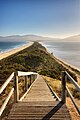 "The Neck" connects the two halves of Bruny Island and is an important breeding site for short-tailed shearwater and fairy penguins
 Black-faced cormorants (Phalacrocorax fuscescens), Bruny Island, Tasmania
 Rock formation off the coast of Bruny Island


See also
References
- "Bruny Island". Britannica Online. Retrieved 17 August 2008.
- Gibbons, Ray (2016), "Introduction", The Political and Economic Uses of Tasmanian Genocide - the targeted destruction of the Palawa, vol. 1
- "Tasmanian Nomenclature: The Place-Names of the State: A Record of Origins and Dates". The Mercury. 16 September 1911. p. 10. Retrieved 23 August 2021.
- Flora Fox, Flora Fox, News and Information about Southern Tasmania Archived 17 July 2011 at the Wayback Machine 2011
- Giblin, R. W. (1928). The early history of Tasmania.
- Nicholson, Ian Hawkins (1983). Shipping Arrivals and Departures, Tasmania, 1803-1833 (First ed.). Canberra: Roebuck. p. 14. ISBN 0909434220.
- Evans, Kathryn (1993). Site Histories. Shore-based whaling in Tasmania historical research project. Vol. 2. Hobart: Tasmanian Parks and Wildlife Service. pp. 11–12. OCLC 224493764.
- Evans 1993, p. 17
- Evans 1993, p. 12
- Elder, Bruce (13 February 1999). "Rock of Ages". The Sydney Morning Herald.
- "IBA: Bruny Island". Birdata. Birds Australia. Archived from the original on 6 July 2011. Retrieved 6 June 2011.
- "Inquiry into the problem of feral and domestic cats in Australia" (PDF). The Australian Mammal Society. 21 July 2020. Retrieved 23 August 2021.
- "Statistics - Tasmania,2002". Australian Bureau of Statistics. Retrieved 10 August 2008.
- "Tas Country Hour Feature Stories". ABC Rural Online. Retrieved 10 August 2008.
- "Cape Bruny Lighthouse". Parks & Wildlife Tasmania. Retrieved 30 October 2019.
- "Cape Bruny Lighthouse History". Cape Bruny Lighthouse Tours. Retrieved 30 October 2019.
- "Places Visited, Tasmanian Tourism Visitor Survey June 2011". Tourism Tasmania. Archived from the original on 25 April 2012. Retrieved 12 November 2011.
- "Places Stayed Overnight, Tasmanian Tourism Visitor Survey June 2011". Tourism Tasmania. Archived from the original on 25 April 2012. Retrieved 12 November 2011.
- Kelly, Chris (31 October 2020). "What To Do on Bruny Island: The Day Trip". Hunter and Bligh. Retrieved 3 December 2020.
- Department of Tourism, Parks Heritage and the Arts., Tasmanian Government. "Wildlife - Quolls" (PDF). brunyisland.net.au. Archived (PDF) from the original on 17 February 2022.
External links
- Bruny Island at Curlie has links to Bruny Island businesses and information.
 Bruny Island travel guide from Wikivoyage
| Buildings and structures: |
|
|---|---|
| Institutions: |
|
| Entertainment: |
|
| Galleries and museums: |
|
| Sports: |
|
| Transport: |
|
| Nature and parks: |
|
| Precincts: |
|
| Beaches and islands: | |
Southern region of Tasmania, Australia | |||||
|---|---|---|---|---|---|
| City Other settlements |
| ||||
| Governance |
| ||||
| Mountains | |||||
| Protected areas, parks and reserves |
| ||||
| Rivers | |||||
| Harbours, bays, inlets and estuaries |
| ||||
| Coastal features |
| ||||
| Transport |
| ||||
| Landmarks |
| ||||
| Islands | |||||
| Books and newspapers |
| ||||
| Flora, fauna, and fishlife |
| ||||
| Bioregions | |||||
| Indigenous heritage |
| ||||
| Other |
| ||||
| |||||
На других языках
[de] Bruny Island
Bruny Island ist eine Insel, die südöstlich von Tasmanien, Australien, liegt und von der Hauptinsel durch den D’Entrecasteaux-Kanal getrennt wird. Sowohl der Kanal als auch die Insel sind nach dem französischen Entdecker Joseph Bruny d’Entrecasteaux benannt. 1918 wurde die Schreibweise „Bruni“ in „Bruny“ geändert.- [en] Bruny Island
[fr] Île Bruny
L'île Bruny, en anglais Bruny Island, en tasmanien Lunawanna Allonah[1] est une île d'Australie, située sur la côte sud-est de la Tasmanie et séparée de cette dernière par le canal d'Entrecasteaux. Tous deux portent le nom de l'explorateur français Antoine Bruny d'Entrecasteaux. Les Aborigènes l'appelaient Alonnah Lunawanna, nom qui subsiste en deux localités, Alonnaz et Lunawanna sur la moitié sud.[it] Bruny Island
Bruny Island è un'isola situata lungo la costa sud-orientale della Tasmania, dalla quale è separata dal canale di D'Entrecasteaux. Sia l'isola che il canale prendono il nome dall'esploratore francese Antoine Bruni d'Entrecasteaux. L'isola era nota agli aborigeni della Tasmania col nome di Alonnah-Lunawanna, ed infatti i due insediamenti presenti su di essa si chiamano, rispettivamente, Alonnah e Lunawanna.[ru] Бруни (остров)
Бруни (англ. Bruny Island) — остров в Тасмановом море у юго-восточного побережья острова Тасмания, от которого отделён проливом Д'Антркасто. Находится южнее реки Деруэнт[1]. Назван в честь французского исследователя Жозефа Антуана де Брюни Д'Антркасто.Другой контент может иметь иную лицензию. Перед использованием материалов сайта WikiSort.org внимательно изучите правила лицензирования конкретных элементов наполнения сайта.
WikiSort.org - проект по пересортировке и дополнению контента Википедии