geo.wikisort.org - Island
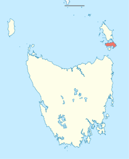
Cape Barren Island, officially truwana / Cape Barren Island,[6] is a 478-square-kilometre (185 sq mi) island in the Bass Strait, off the north east coast of Tasmania, Australia. It is the second largest island of the Furneaux Group; Flinders Island lies to the north, with the smaller Clarke Island to the south. The highest point on the island is Mount Munro at 715 metres (2,346 ft).[4] Mount Munro is probably named after James Munro (c. 1779-1845), a former convict and then sealer, who lived from the 1820s for more than 20 years with several women on nearby Preservation Island.
Native name: truwana | |
|---|---|
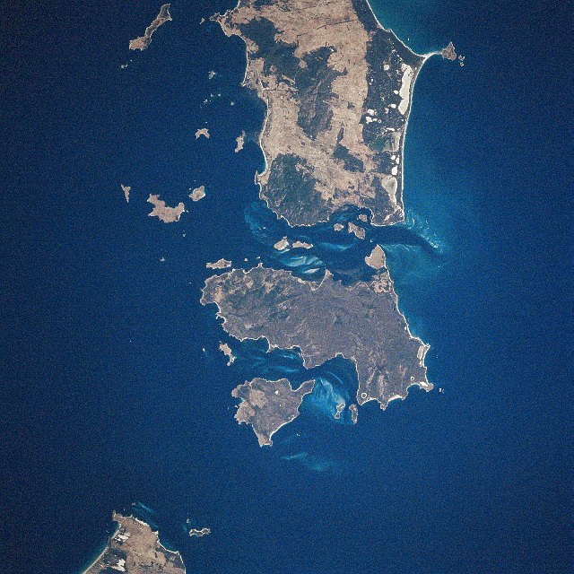 Cape Barren Island (center) from space, January 1997 | |
 Cape Barren Island (Tasmania) | |
| Geography | |
| Location | Bass Strait |
| Coordinates | 40.402°S 147.991°E[1] |
| Area | 478.4 km2 (184.7 sq mi)[3] |
| Highest elevation | 715 m (2346 ft)[4] |
| Highest point | Mount Munro |
| Administration | |
Australia | |
| State | Tasmania |
| LGA | Municipality of Flinders Island |
| Largest settlement | The Corner (pop. 60) |
| Demographics | |
| Population | 66 (2016) |
| Pop. density | 0.14/km2 (0.36/sq mi) |
Ramsar Wetland | |
| Official name | Cape Barren Island,east coast lagoons |
| Designated | 16 November 1982 |
| Reference no. | 256[5] |
The south-eastern point of the island was named Cape Barren by Tobias Furneaux in HMS Adventure in March 1773.[7]
The island was gazetted as a locality of the Flinders Council in 1968. The population of the island numbered 66 in 2016,[8] most of them in the settlement Cape Barren Island, also called The Corner, on the northwest coast.[9]
Australia's only native goose, the Cape Barren goose, was first documented by European explorers on this island.[citation needed]
History
Sealing is known to have taken place here from 1798 when the 80-ton brig Nautilus (Captain Charles Bishop) arrived from Sydney to commence commercial sealing in Bass Strait.[10] They began operations in Kent’s Bay and took nearly 9000 seal skins that first season. Other vessels followed from Sydney and the United States. Competition between the sealing gangs led to a violent clash between American and British sealers in 1803.[11]
Today the residents of Cape Barren Island consist of an Aboriginal community of approximately 70 people. Most of the residents are descended from a community of mixed descent (European and Aboriginal people) who had originally settled on several smaller nearby islands but relocated to Cape Barren Island in the late 1870s.[12] The Colonial Government of Tasmania established a formal reserve in 1881 and commenced providing basic social services to the community. By 1908 the population had grown to 250 people.

More active government intervention began in 1912 with the passage of the Cape Barren Act.[13] The stated purpose of this act was to encourage the community to become self-sufficient through both incentives and disincentives. Government visits throughout the 1920s and 1930s reported poor health and education and proposals were made to remove children from their parents, ostensibly for their own benefit. Under threat of losing their children many families relocated to mainland Tasmania. By 1944 the population had fallen to 106.[12] From the 1950s the government did indeed remove children from their parents. This forced removal of children was part of a wider policy implemented in many parts of Australia and over a number of decades that resulted in the phenomenon known as the 'stolen generations'. From the 1970s a series of changed government policies were implemented that provided increasingly greater recognition of the personal and social rights of individuals.[14]
On 10 May 2005, the government released Crown lands on both Cape Barren and Clarke Island to be overseen by the local Aboriginal association.[15] This marked the first official handover of Crown land to an Aboriginal community in Tasmania.
East coast lagoons Ramsar site
On 16 November 1982, the east coast lagoons were recognised as being wetlands of international importance by being designated Ramsar site no.256. The site comprises a 4,370-hectare (10,800-acre) complex of shallow, saline lagoons among stretches of coastal dunes and beaches. It supports various plants of special botanical interest, including nationally rare species, as well as many waterbirds.[16]
Access
Airlines of Tasmania operates a twice-weekly scheduled air service from Launceston. Various charter flight operators offer charter flights from either Tasmania, Australia or Victoria, Australia.
From Flinders Island, Cape Barren island is only a short boat trip away. Cape Barren, with the other islands in the Furneaux Group, are a popular destination for sea kayakers who attempt the crossing of Bass Strait from the Australian mainland at Wilsons Promontory, Victoria to the Tasmanian mainland.
See also
References
- "Cape Barren Island, Tasmania (Islands & Reefs)". Gazetteer of Australia online. Geoscience Australia, Australian Government. Retrieved 29 December 2009.
- "Cape Barren Island, Tasmania (Islands & Reefs)". Gazetteer of Australia online. Geoscience Australia, Australian Government. Retrieved 29 December 2009.
- "UN System-Wide Earthwatch Web Site Island Directory Tables Islands by Altitude". web page. United Nations Environment Programme (UNEP). 18 February 1998. Retrieved 4 June 2011.
- "Island Directory Tables: Islands by Altitude". UN System-Wide Earthwatch Web Site. United Nations Environment Programme (UNEP). 18 February 1998. Retrieved 4 June 2011.
- "Cape Barren Island,east coast lagoons". Ramsar Sites Information Service. Retrieved 25 April 2018.
- "Survey Co-ordination (21403)" (PDF). Tasmanian Government Gazette. 5 February 2014. p. 155. Retrieved 3 January 2020.
- Sprod, Dan (2005). "Furneaux, Tobias (1735–1781)". Australian Dictionary of Biography. Melbourne University Press. ISSN 1833-7538. Retrieved 5 May 2008 – via National Centre of Biography, Australian National University.
- "2016 Census QuickStats: Cape Barren Island". www.censusdata.abs.gov.au. Retrieved 16 April 2018.
- "National Museum of Australia - Cape Barren Island, TAS". Archived from the original on 28 September 2007. Retrieved 10 June 2009.
- Kostoglou, Parry (1996). Sealing in Tasmania historical research project (First ed.). Hobart: Parks and Wildlife Service. pp. 81–6.
- Kostoglou, p.82-4.
- "The 'Black War'". Retrieved 10 October 2007.
- "THE CAPE BARREN ISLAND RESERVE ACT,1912" (PDF). 1912. Archived from the original (PDF) on 6 October 2007. Retrieved 10 October 2007.
- "The Laws: Tasmania". Archived from the original on 13 September 2007. Retrieved 10 October 2007.
- "ABORIGINAL AFFAIRS - POLICY ADVICE AND COMMUNITY SERVICES". 2005. Archived from the original on 1 September 2007. Retrieved 2007-10-10.
- "The Annotated Ramsar List: Australia". The Ramsar Convention on Wetlands. 4 January 2000. Archived from the original on 19 September 2011. Retrieved 29 March 2010.
| Authority control |
|
|---|
На других языках
[de] Cape Barren Island
Cape Barren Island ist die zweitgrößte Insel der Furneaux-Gruppe am Ostrand der Bass-Straße zwischen der Insel Tasmanien und dem Kontinent Australien. Sie hat eine Fläche von 464 km². Die größte Insel der Gruppe, Flinders Island, liegt nördlich, die drittgrößte Insel Clarke Island südlich. Die Ureinwohner nennen die Insel Truwana.[1] Sie liegt in den Roaring Forties.- [en] Cape Barren Island
[fr] Île du Cap Barren
L'île du Cap Barren, ou Cape Barren Island en anglais, est une île australienne située à la limite orientale du détroit de Bass et qui fait partie de l'archipel Furneaux. Au nord, l'île du Cap Barren est isolée de l'île Flinders par le Franklin Sound, un détroit orienté est-ouest et large de 7,7 km dans sa partie la plus étroite. Une distance de 33 km vers le sud-sud-ouest la sépare des environs de Cape Portland, à l'extrémité nord-est de la Tasmanie. Comme les îles voisines, elle relève de l'État de Tasmanie.[it] Cape Barren Island
Cape Barren Island (nome aborigeno Truwana) è un'isola del gruppo delle Furneaux in Tasmania (Australia). L'isola appartiene alla municipalità di Flinders una delle Local Government Area della Tasmania. La popolazione dell'isola era di 66 persone nel 2016[2]; la maggior parte di loro, una comunità aborigena di discendenza mista, si trova nell'insediamento chiamato anche The Corner, sulla costa nord-occidentale dell'isola.[ru] Кейп-Баррен
Кейп-Баррен (англ. Cape Barren) — остров в архипелаге Фюрно в проливе Басса. Расположен к северо-востоку от побережья острова Тасмания. К северу от острова Кейп-Баррен расположен крупнейший остров архипелага Фюрно — остров Флиндерс. Численность населения в 2006 году составляла 268 человек.Другой контент может иметь иную лицензию. Перед использованием материалов сайта WikiSort.org внимательно изучите правила лицензирования конкретных элементов наполнения сайта.
WikiSort.org - проект по пересортировке и дополнению контента Википедии