geo.wikisort.org - Island
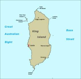
King Island is an island in the Bass Strait, belonging to the Australian state of Tasmania. It is the largest of three islands known as the New Year Group, and the second-largest island in Bass Strait (after Flinders Island). The island's population at the 2016 census was 1,585 people,[2] up from 1,566 in 2011.[3] The local government area of the island is the King Island Council.
 | |
 King Island Location of King Island in Tasmania | |
| Etymology | Philip Gidley King |
|---|---|
| Geography | |
| Location | Roaring Forties, Great Australian Bight and Bass Strait |
| Coordinates | 39°52′21″S 143°59′8″E |
| Archipelago | New Year Group |
| Area | 1,098 km2 (424 sq mi) |
| Area rank | 3rd in Tasmania |
| Highest elevation | 162 m (531 ft)[1] |
| Highest point | Gentle Annie |
| Administration | |
Australia | |
| State | Tasmania |
| LGA | Municipality of King Island |
| Largest settlement | Currie |
| Demographics | |
| Population | 1585 (2016 census)[2] |
| Pop. density | 1.50/km2 (3.88/sq mi) |
| Additional information | |
| Official website | kingisland |
The island forms part of the official land divide between the Great Australian Bight and Bass Strait, off the north-western tip of Tasmania and about halfway to the mainland state of Victoria. The southernmost point is Stokes Point and the northernmost point is Cape Wickham. There are three small islands immediately offshore: New Year Island and Christmas Island situated to the northwest, and a smaller island Councillor Island to the east, opposite Sea Elephant Beach.[4]
King Island was first visited by Europeans in the late 18th century. It was named after Philip Gidley King, Colonial Governor of New South Wales, whose territory at the time included what is now Tasmania. Sealers established temporary settlements on the island in the early 19th century, but it was not until the 1880s that permanent settlements were established. The largest of these is Currie, situated on the island's west coast. Today, the island's economy is largely based on agriculture and tourism. It is also home to the Huxley Hill Wind Farm.
History
King Island was originally part of a land bridge linking Tasmania with the Australian mainland, which was submerged around 12,000 years ago due to rising sea levels. A human skeleton was discovered in a cave on the island in 1989, which was dated to approximately 14,000 years ago.[5] However, previous examinations had revealed no "shell heaps, bones, charcoal or other remains which might indicate Aboriginal occupation", suggesting that the area was passed through by the ancestors of Aboriginal Tasmanians but not permanently inhabited. It was uninhabited at the time of European discovery.[citation needed]
Captain Reed is the first known European to discover King Island in 1799 while hunting seals in the schooner Martha. Matthew Flinders’ first map of "Van Diemen's Land" and "Basses Strait",[6] which was sent to England (before Flinders had left) and was published in June 1800, did not show King Island. However, before Flinders left Sydney for England in 1800, Captain Black had informed Flinders of the existence of the island. Flinders' second map of Van Diemen's Land and Bass's Strait (properly finished en route to England) and published with his Observations[7] in 1801 shows:[8]
"Land of considerable extent has been seen about this situation".
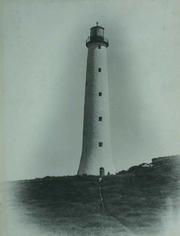
Although the impressive 48-metre (157 ft) granite tower, Australia's tallest lighthouse,[9] was finished and the light first lit on 1 November 1861, the Cape Wickham Lighthouse was only officially opened in November 2011 at a community celebration of the light's 150th anniversary.[10][11]
Captain John Black also visited the island just after Reed and named it King's Island after Governor Philip Gidley King. Captain John Black was sailing in the brig Harbinger, after which the dangerous Harbinger Rocks off the island's north-west coast are named. It was found to abound in both fur seals and Southern elephant seals that were soon exploited to local extinction.
Governor King, knowing that the French navigator Nicolas Baudin was going to head for the island, when he left Port Jackson in 1800, sent the Cumberland from Sydney to formally claim the islands for Britain. The Cumberland arrived just before the French and the British had hastily erected the British Flag in a tree.[12] Baudin still circumnavigated and extensively mapped the Island in 1802, giving French names to some localities which are still in use today like "Phoques Bay" on the north-west coast.
As a result of this incident, British settlements were established at the River Derwent and Port Dalrymple in Tasmania and later Port Phillip.
Sealers continued to harvest the island intermittently until the mid-1820s, after which the only inhabitants were some old sealers and their Australian Aboriginal wives who mostly hunted wallaby for skins. The last of these left the island in 1854 and for many years it was only occasionally visited by hunters and more often castaways from shipwrecks.
The first submarine communications cable across Bass Strait in 1859 went via King Island, starting at Cape Otway, Victoria. It made contact with the Tasmanian mainland at Stanley Head, and then continued on to George Town. However it started failing within a few weeks of completion, and by 1861 it failed completely. A later telephone and telegraph cable across Bass Strait operated via King Island from 1936 until 1963.
In the 1880s the land was opened for grazing. A township developed at Currie and the post office opened on 1 June 1892 (known as King's Island until 1903, King Island until 1917, thereafter Currie).[13] Currie, on the west coast, now has the only post office on the island, but in the past Grassy, in the southeast (1918–35, 1943–91), Naracoopa on the east coast (1920–62), Pearshape to the south (1946–59) and Egg Lagoon in the north (1925–67) replacing Yambacoona (1922–25) all had official post offices. The other localities of King Island are Bungaree, Loorana, Lymwood, Nugara, Pegarah, Reekara, Sea Elephant, Surprise Bay, Wickham and Yarra Creek.[13] All share the postcode 7256.
Shipwrecks
![Wreck of the Cataraqui, Australia's deadliest maritime disaster with 400 victims. 314 recovered bodies lie buried on King Island in five graves.[14]](http://upload.wikimedia.org/wikipedia/commons/9/91/Cataraqui_wreck.jpg)
Situated in the centre of the western entrance to Bass Strait, King Island has been the location of over 60 known shipwrecks, involving the loss of over 2,000 lives. Many King Islanders are descendants of shipwreck survivors.[14] Notable shipwrecks include:
- 1801, large unidentified three-masted full-rigged ship, probably a whaler. No survivors known.
- 1835, Neva, convict ship 327 tons, 225 lives lost.
- 1840, Isabella, full-rigged ship 287 tons, no lives lost.
- 1843, Rebecca, barque 243 tons, five lives lost.
- 1845, Cataraqui, full-rigged ship 802 tons, 400 lives lost.
- 1854, Brahmin, full-rigged ship 616 tons, 17 lives lost.
- 1854, Waterwitch, schooner 134 tons, no lives lost.
- 1855, Whistler, American clipper ship, 942 tons, two lives lost.
- 1855, Maypo, brig 174 tons, two lives lost.
- 1865, Arrow, schooner 166 tons, one life lost.
- 1866, Netherby, full-rigged ship 944 tons, no lives lost.
- 1871, Loch Leven, iron clipper ship 1868 tons, one life lost.
- 1874, British Admiral, iron clipper ship, 79 lives lost.
- 1875, Blencathra, iron barque, 933 tons, no lives lost.
- 1910, Carnarvon Bay, steel full-rigged ship 1932 tons, no lives lost.
- 1920, Southern Cross, timber, three-masted brigantine, 257 tons, at least 9 lives lost.
The island today

Currie
Currie, the largest town and administrative centre, is situated on the west coast of the island.
Grassy
The township of Grassy, on the island's east coast, is approximately 32 km south east of Currie. It was a thriving mining town where scheelite was extracted from an open cut mine until 1974 when two underground mines were brought into production. After the mine closed in 1990, the mine site was rehabilitated, the town sold and the pit was allowed to flood.
In recent years the Grassy population has increased again and consists of local families, sea-changers, a campus of Ballarat Clarendon College and holiday makers. There is a service station, a supermarket and several shops and restaurants. Grassy is also known for the little penguin rookery near the port (safe harbour) and platypus at the Upper Grassy Dam. There are ferries servicing the island with a weekly shipping services between Victoria, Northern Tasmania and Grassy Harbour.[15]
A new $12.3 million wave power demonstration project is planned. Sitting partially submerged on the seabed, the Uniwave 200 will use oscillating water column technology to push air into a chamber fitted with an electricity-generating turbine.[16]
Naracoopa
The village of Naracoopa is situated on the east coast about 20 kilometres (12 mi) from Currie and is known for its beach, jetty (fishing), holiday accommodation and eateries. There is a sheltered BBQ area and public toilets on the foreshore.
Naracoopa was the chief bulk fuels port and depot and is the site of a mineral sands deposit from which rutile, zircon and ilmenite were extracted between 1968 and 1977. The attractions of Naracoopa are the 100 year old Naracoopa Jetty, blow hole and calmer weather.[17]
Economy and culture
The island is noted for its production of cheese, lobsters, bottled rain water, kelp, and beef. The island's beef industry was seriously affected by the closure of the island's only abattoir, owned by Argentinian company JS Swift, in September 2012. It is a safe harbour for passing yachts and the site of the Huxley Hill Wind Farm operated by Hydro Tasmania.
The island has a football competition, The King Island Football Association, with just three teams, Currie, Grassy and North, competes annually in the Stonehaven Cup boat races, the Imperial 20-foot race, Queen's Birthday Weekend Pheasant Season and many other activities.
The island was the proposed location for the development of Australia's largest windfarm. This wind farm split the community into those for and against but eventually proved uneconomic to construct. The proposal was shelved in late 2014.
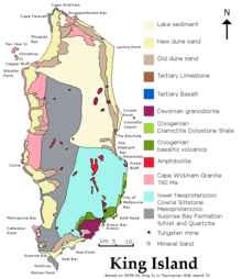
The Dolphin mine, located on the southeast side of the island, is one of the largest tungsten reserves in Australia.[18]
Environment
Birds

The King Island emu was endemic to the island. Although numerous bones have been found, the only existing skin was collected by Nicolas Baudin in 1802, shortly before the species became extinct, probably as a result of hunting by sealers for food.[19]
Some 193 km2 of the island, consisting of the coastline in a strip extending from the low water mark to one kilometre inland of the high-water mark around the entire island, with a broader area encompassing Lavinia State Reserve in the north-east, has been identified by BirdLife International as an Important Bird Area (IBA). The main feature making it an IBA is that it supports the small population of critically endangered orange-bellied parrots (Neophema chrysogaster) on the migration route between their breeding grounds in south-western Tasmania and their wintering grounds in mainland south-eastern Australia.[20] And more recently the King Island Biodiversity Management Plan 2012–2022 identified Lake Flannigan as important in this regard.[21]
The IBA includes the nearby Christmas, New Year and Councillor Islands which support breeding seabirds and waders.[20] The IBA supports significant numbers of hooded plovers, flame robins and fairy terns, over 1% of the world populations of short-tailed shearwaters, pied and sooty oystercatchers, black-faced cormorants and pacific gulls, as well as populations of ten bird species endemic to Tasmania, including seven subspecies endemic to King Island.[22]
Climate
King Island has a borderline Mediterranean (Csb)/oceanic climate (Cfb) with mild summers and wet winters.
| Climate data for King Island | |||||||||||||
|---|---|---|---|---|---|---|---|---|---|---|---|---|---|
| Month | Jan | Feb | Mar | Apr | May | Jun | Jul | Aug | Sep | Oct | Nov | Dec | Year |
| Record high °C (°F) | 37.8 (100.0) |
37.6 (99.7) |
35.0 (95.0) |
30.0 (86.0) |
23.1 (73.6) |
18.6 (65.5) |
18.0 (64.4) |
19.6 (67.3) |
26.5 (79.7) |
29.5 (85.1) |
33.0 (91.4) |
36.0 (96.8) |
37.8 (100.0) |
| Average high °C (°F) | 20.3 (68.5) |
20.6 (69.1) |
19.6 (67.3) |
17.2 (63.0) |
15.1 (59.2) |
13.5 (56.3) |
12.9 (55.2) |
13.2 (55.8) |
14.3 (57.7) |
15.6 (60.1) |
17.0 (62.6) |
18.7 (65.7) |
16.5 (61.7) |
| Average low °C (°F) | 12.5 (54.5) |
13.1 (55.6) |
12.6 (54.7) |
11.2 (52.2) |
9.8 (49.6) |
8.5 (47.3) |
7.8 (46.0) |
7.8 (46.0) |
8.3 (46.9) |
9.0 (48.2) |
9.9 (49.8) |
11.3 (52.3) |
10.2 (50.4) |
| Record low °C (°F) | 6.4 (43.5) |
7.0 (44.6) |
6.1 (43.0) |
2.0 (35.6) |
1.1 (34.0) |
1.0 (33.8) |
−0.5 (31.1) |
−0.5 (31.1) |
1.7 (35.1) |
0.0 (32.0) |
0.6 (33.1) |
4.6 (40.3) |
−0.5 (31.1) |
| Average precipitation mm (inches) | 35.6 (1.40) |
38.8 (1.53) |
48.0 (1.89) |
67.8 (2.67) |
98.0 (3.86) |
102.4 (4.03) |
124.1 (4.89) |
114.7 (4.52) |
84.2 (3.31) |
74.8 (2.94) |
59.8 (2.35) |
52.3 (2.06) |
900.2 (35.44) |
| Average precipitation days | 6.4 | 6.2 | 8.3 | 11.6 | 15.3 | 16.5 | 19.3 | 18.8 | 15.4 | 13.1 | 10.3 | 8.7 | 149.9 |
| Source: Bureau of Meteorology."[23] | |||||||||||||
See also
- Huxley Hill Wind Farm
- King Island Airport
References
- Morgan, H. (1998). King Island Natural Resource Management Review and Strategic Action Plan 1998–2001. KINRMG, Currie.
- Australian Bureau of Statistics (27 June 2017). "King Island (SA2)". 2016 Census QuickStats. Retrieved 21 March 2018.
- Australian Bureau of Statistics (31 October 2012). "King Island (M)". 2011 Census QuickStats. Retrieved 5 July 2016.
- "Placenames Tasmania". Land Tasmania. Department of Primary Industries, Parks, Water and Environment. Retrieved 3 June 2017.
- Robin Sim and Alan Thorne (December 1990). "Pleistocene human remains from King Island, southeastern Australia". Australian Archaeology. 31: 44–51. doi:10.1080/03122417.1990.11681387.
- This map is held at the National Library of Australia, Canberra
- Observations on the coast of Van Diemen's Land, on Bass's Strait and its Islands, and on Parts of the coast of New South Wales-By Matthew Flinders 1801
- common map dated 1798–99 and showing "land seen"
- Ashworth, Susie; Bain, Carolyn; Smitz, Paul. Lonely Planet Australia. Lonely Planet, 2004. ISBN 1-74059-447-9, p. 653
- Foster, Margot (4 November 2011). "Cape Wickham lighthouse turns 150". Australian Broadcasting Corporation. Retrieved 6 November 2011.
- "Governor-General of Australia: Events: Governor-General opens Cape Wickham Lighthouse". Office of the Governor General of the Commonwealth of Australia. Archived from the original on 27 February 2012. Retrieved 6 November 2011.
- The Journal of Post Captain Nicolas Baudin—Libraries Board of South Australia 1974
- Phoenix Auctions History, Post Office List, retrieved 17 February 2021
- Baglin, Douglass; Mullins, Barbara. Islands of Australia. Sydney: Ure Smith Pty Limited, 1972. ISBN 0-7254-0084-6, p. 31
- "King Island Shipping". kingisland.net.au.
- "Full steam ahead for King Island wave power trial - ARENAWIRE". Australian Renewable Energy Agency. Retrieved 12 January 2021.
- "King Island". Archived from the original on 2 February 2009. Retrieved 6 August 2012.
- "Tungsten deposits" (PDF). masangroup.com. 2012. Archived from the original (PDF) on 22 September 2013. Retrieved 5 July 2013.
- BirdLife International. (2011). Species factsheet: Dromaius ater. Downloaded from http://www.birdlife.org on 2011-07-16.
- BirdLife International. (2011). Important Bird Areas factsheet: King Island. Downloaded from http://www.birdlife.org on 2011-07-16.
- "King Island Biodiversity Management Plan: 2012–20" (PDF). Australian Government Department of Environment and Energy: Resource. Tasmanian Government, Department of Primary Industries, Parks, Water and Environment. Retrieved 22 May 2017.
- "IBA: King Island". Birdata. Birds Australia. Archived from the original on 6 July 2011. Retrieved 16 July 2011.
- "Climate statistics for Australian locations". bom.gov.au.
External links
- Municipality of King Island
- Currie climate averages (Australian Bureau of Meteorology)
- Australian Places - King Island
attribution contains material published under Creative Commons Attribution 2.5 Australia licence from https://arena.gov.au/blog/king-island-wave-power/ attribution: Australian Renewable Energy Agency.
Authority control | |
|---|---|
| General | |
| National libraries | |
На других языках
[de] King Island (Tasmanien)
King Island ist eine Insel, die zum australischen Bundesstaat Tasmanien gehört. Sie liegt am westlichen Ende der Bass-Straße (Bass Strait) zwischen Tasmanien und dem australischen Festland. Sie ist mit einer Fläche von 1.098 km² die mit Abstand größte und einzig bewohnte Insel der New-Year-Island-Gruppe. Zusammen mit der Furneaux-Gruppe auf der Ostseite Tasmaniens bilden diese Inseln sichtbare Überbleibsel der ehemaligen Landbrücke zum australischen Festland.- [en] King Island (Tasmania)
[es] Isla King (Australia)
La isla King es una de las islas que conforman el estado de Tasmania, en Australia. Localizada en el extremo occidental del estrecho de Bass, se encuentra aproximadamente a mitad de camino entre Tasmania y Victoria. La isla debe su nombre a Philip Gidley King, quien fuera gobernador de Nueva Gales del Sur en la época en que Tasmania formaba parte del territorio de dicho estado.[fr] Île King (Tasmanie)
L’île King fait partie de la Tasmanie, en Australie. Elle est située dans le détroit de Bass au large de l'extrémité nord-ouest de la principale île de l'État, à mi-distance entre cette île et l'État de Victoria. Elle doit son nom au capitaine Philip Gidley King, gouverneur de la Nouvelle-Galles du Sud à l'époque où la Tasmanie était rattachée à cet État. L'administration de l'île est confiée au King Island Council.[it] King (isola)
L'isola di King è una delle isole che compongono lo Stato della Tasmania, in Australia. È situata nello Stretto di Bass, al largo della punta nord-occidentale della Tasmania, a metà strada tra la Tasmania ed il Victoria. L'isola prende nome dal Governatore Philip G. King (1758-1808) del Nuovo Galles del Sud, il cui territorio all'epoca comprendeva la Tasmania.[ru] Кинг (остров, Тасмания)
Кинг (англ. King Island) — остров в Бассовом проливе недалеко от северо-западной оконечности острова Тасмания, принадлежит Австралии, входит в состав штата Тасмания. Площадь острова 1098 км², население 1723[1] человек (2007), средний возраст 43,1 года.Другой контент может иметь иную лицензию. Перед использованием материалов сайта WikiSort.org внимательно изучите правила лицензирования конкретных элементов наполнения сайта.
WikiSort.org - проект по пересортировке и дополнению контента Википедии