geo.wikisort.org - Island
Round Top Island is an island located close to the south-western coast of Tasmania, Australia. The 6.25-hectare (0.0241 sq mi) island is part of the Maatsuyker Islands Group, and comprises part of the Southwest National Park and the Tasmanian Wilderness World Heritage Site.[1][2]
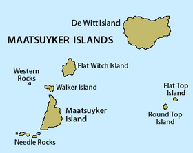 Detailed map of the Maatsuyker Islands Group, showing Round Top Island in the bottom right. | |
| Geography | |
|---|---|
| Location | South West Tasmania |
| Coordinates | 43°38′24″S 146°22′12″E |
| Archipelago | Maatsuyker Islands Group |
| Adjacent bodies of water | Southern Ocean |
| Area | 6.25 ha (15.4 acres)[1] |
| Highest elevation | 165 m (541 ft) |
| Administration | |
Australia | |
| State | Tasmania |
| Region | South West |
| Demographics | |
| Population | Unpopulated |

The island's highest point is 165 metres (541 ft) above sea level.
Fauna
The island is part of the Maatsuyker Island Group Important Bird Area, identified as such by BirdLife International because of its importance as a breeding site for seabirds.[3] Recorded breeding seabird species are the short-tailed shearwater (8900 pairs), fairy prion (9300 pairs), common diving-petrel (8700 pairs), Pacific gull and silver gull. The metallic skink and Tasmanian tree skink are present.[2]
See also
- South East Cape
- South West Cape
- List of islands of Tasmania
References
- "Small Southern Islands Conservation Management Statement 2002" (PDF). Tasmania Parks and Wildlife Service. 2002. Archived from the original (PDF) on 22 August 2006. Retrieved 20 July 2006.
- Brothers, Nigel; Pemberton, David; Pryor, Helen; & Halley, Vanessa. (2001). Tasmania’s Offshore Islands: seabirds and other natural features. Tasmanian Museum and Art Gallery: Hobart. ISBN 0-7246-4816-X
- BirdLife International. (2011). Important Bird Areas factsheet: Maatsuyker Island Group. Downloaded from http://www.birdlife.org on 09/08/2011.
This Tasmania geography article is a stub. You can help Wikipedia by expanding it. |
Другой контент может иметь иную лицензию. Перед использованием материалов сайта WikiSort.org внимательно изучите правила лицензирования конкретных элементов наполнения сайта.
WikiSort.org - проект по пересортировке и дополнению контента Википедии