geo.wikisort.org - Mountains
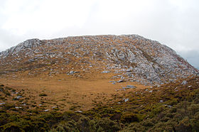
The Frankland Range is a mountain range that is located in the south-west region of Tasmania, Australia. The range forms part of a natural south-western border to the impounded Lake Pedder, formed by the damming of the Serpentine and Huon rivers.
| Frankland Range | |
|---|---|
 The Cupola, one of the peaks in the range. | |
| Highest point | |
| Peak | Frankland Peak |
| Elevation | 1,083 m (3,553 ft)[1] AHD |
| Coordinates | 42°58′48″S 146°08′24″E[2] |
| Geography | |
 Location of the Frankland Range in Tasmania | |
| Country | Australia |
| State | Tasmania |
| Region | South West |
| Range coordinates | 42°59′S 146°09′E |
As part of the South West Wilderness area, it is a less popular site of bushwalking than other, more famous, ranges in Tasmania's South West, and is for much more advanced walkers due to its length, isolation and terrain. Access routes to the range are by boat from the lake, or the roads at Strathgordon or Scotts Peak Dam.[3]
Nearby ranges include the Arthur, Companion, Folded, Tribulation, and the Wilmot ranges.
Notable peaks
| Rank | Name | Height | Location | Notes |
|---|---|---|---|---|
| 1 | Frankland Peak | 1,083 metres (3,553 ft) | 42°58′48″S 146°08′24″E | [1][2] |
| 2 | Secheron Peak | 1,068 metres (3,504 ft) | 42°59′14″S 146°09′21″E | |
| 3 | The Lion | 988 metres (3,241 ft) | 42°56′52″S 146°03′11″E | |
| 4 | Mount Lloyd Jones | 982 metres (3,222 ft) | 42°58′48″S 146°10′14″E | |
| 5 | The Cupola | 970 metres (3,182 ft) | 42°56′16″S 146°03′04″E | [4] |
| 6 | Right Angle Peak | 954 metres (3,130 ft) | 42°59′40″S 146°08′31″E | |
| 7 | Cleft Peak | 946 metres (3,104 ft) | 42°57′45″S 146°05′30″E | |
| 8 | Redtop Peak | 935 metres (3,068 ft) | 42°56′10″S 146°02′20″E | |
| 9 | The Citadel | 929 metres (3,048 ft) | 42°57′20″S 146°04′00″E | |
| 10 | Greycap | 898 metres (2,946 ft) | 42°58′16″S 146°06′25″E | |
| 11 | Murpheys Bluff | 881 metres (2,890 ft) | 42°57′16″S 146°04′48″E | |
| 12 | Terminal Peak | 785 metres (2,575 ft) | 42°58′56″S 146°11′59″E |
See also
References
- Solitary (Map) (1st ed.). 1:25000. Tasmania: Tasmap. 2001.
- "Frankland Peak (TAS)". Gazetteer of Australia online. Geoscience Australia, Australian Government.
- Chapman, John. South West Tasmania (4th ed.). pp. 173–175.
- "The Cupola (TAS)". Gazetteer of Australia online. Geoscience Australia, Australian Government.
External links
- http://tqft.net/wiki/Frankland_Range
- "The Frankland Range: 26–31 January 2013". rockmonkeyadventures. January 2013.
На других языках
[de] Frankland Range
Die Frankland Range ist ein Gebirgszug im Südwesten des australischen Bundesstaates Tasmanien, ein Teil der Great Dividing Range. Sie erstreckt sich entlang des Westufers des Lake Pedder in Nordwest-Südost-Richtung im nördlichen Teil des Southwest-Nationalparks.- [en] Frankland Range
Текст в блоке "Читать" взят с сайта "Википедия" и доступен по лицензии Creative Commons Attribution-ShareAlike; в отдельных случаях могут действовать дополнительные условия.
Другой контент может иметь иную лицензию. Перед использованием материалов сайта WikiSort.org внимательно изучите правила лицензирования конкретных элементов наполнения сайта.
Другой контент может иметь иную лицензию. Перед использованием материалов сайта WikiSort.org внимательно изучите правила лицензирования конкретных элементов наполнения сайта.
2019-2025
WikiSort.org - проект по пересортировке и дополнению контента Википедии
WikiSort.org - проект по пересортировке и дополнению контента Википедии