geo.wikisort.org - Island
The Western Rocks, also known as Black Rocks, are a pair of islets located close to the south-western coast of Tasmania, Australia. The steep, wave-washed 0.29-hectare (0.0011 sq mi) islets are part of the Maatsuyker Islands Group, and comprises part of the Southwest National Park and the Tasmanian Wilderness World Heritage Site.[1][2]
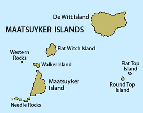 Detailed map of the Maatsuyker Islands Group, showing Western Rocks mid-left. | |
| Geography | |
|---|---|
| Location | South West Tasmania |
| Coordinates | 43°37′48″S 146°15′00″E |
| Archipelago | Maatsuyker Islands Group |
| Adjacent to | Southern Ocean |
| Area | 0.29 ha (0.72 acres)[1] |
| Highest elevation | 165 m (541 ft) |
| Administration | |
Australia | |
| State | Tasmania |
| Region | South West |
| Demographics | |
| Population | Unpopulated |

Fauna
The only recorded breeding seabird species is the fairy prion with up to 20 pairs in a small patch of succulent vegetation.[1][2]
See also
- South East Cape
- South West Cape
- List of islands of Tasmania
References
- "Small Southern Islands Conservation Management Statement 2002" (PDF). Tasmania Parks and Wildlife Service. 2002. Archived from the original (PDF) on 22 August 2006. Retrieved 20 July 2006.
- Brothers, Nigel; Pemberton, David; Pryor, Helen; & Halley, Vanessa. (2001). Tasmania’s Offshore Islands: seabirds and other natural features. Tasmanian Museum and Art Gallery: Hobart. ISBN 0-7246-4816-X
This Tasmania geography article is a stub. You can help Wikipedia by expanding it. |
Текст в блоке "Читать" взят с сайта "Википедия" и доступен по лицензии Creative Commons Attribution-ShareAlike; в отдельных случаях могут действовать дополнительные условия.
Другой контент может иметь иную лицензию. Перед использованием материалов сайта WikiSort.org внимательно изучите правила лицензирования конкретных элементов наполнения сайта.
Другой контент может иметь иную лицензию. Перед использованием материалов сайта WikiSort.org внимательно изучите правила лицензирования конкретных элементов наполнения сайта.
2019-2026
WikiSort.org - проект по пересортировке и дополнению контента Википедии
WikiSort.org - проект по пересортировке и дополнению контента Википедии