geo.wikisort.org - Island
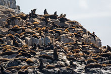
The Tenth Island, sometimes called Barrenjoey, part of the Waterhouse Island Group, is a 900-square-metre (9,700 sq ft) uninhabited granite islet and nature reserve, situated in Bass Strait, lying close to the north-eastern coast of Tasmania, Australia. The islet has no vegetation and much of it is wave-washed in winter storms.[1] The Aboriginal name for the island is recorded as Roobala mangana.[2]
Nickname: Barrenjoey | |
|---|---|
 Tenth Island (Roobala mangana) Location of Tenth Island off the coast of Tasmania | |
| Geography | |
| Location | Bass Strait |
| Coordinates | 40°56′S 146°59′E |
| Archipelago | Waterhouse Island Group |
| Area | 900 m2 (9,700 sq ft) |
| Administration | |
Australia | |
| State | Tasmania |
| Demographics | |
| Population | uninhabited |
Other islands in the Waterhouse Group include Ninth, Maclean, Waterhouse, Little Waterhouse, Baynes, St Helens, Foster, Swan, Little Swan, Cygnet and Paddys islands and Bird Rock and George Rocks islets.[1]
Fauna and marine life

The island is home to a significant breeding colony of Australian fur seals, with up to 400 pups born each year, though many drown in storms. black-faced cormorants also breed on the island and little penguins roost there.[1][3]
In the waters surrounding Tenth Island, Therese Cartwright, aged 35 years and a mother of five children, was killed as a result of a human shark attack fatality on 5 June 1993 when a reportedly 5-metre (16 ft) long great white shark (Carcharodon carcharias) attacked Cartwright while she was scuba diving at the seal colony.[4][5]
See also
References
- Brothers, Nigel; Pemberton, David; Pryor, Helen; & Halley, Vanessa. (2001). Tasmania’s Offshore Islands: seabirds and other natural features. Tasmanian Museum and Art Gallery: Hobart. ISBN 0-7246-4816-X
- Milligan, Joseph (1858). "On the dialects and languages of the Aboriginal Tribes of Tasmania, and on their manners and customs" (PDF). Papers of the Royal Society of Tasmania: 270.
- "Small Bass Strait Island Reserves. Draft Management Plan". Department of Primary Industries,Water and Environment. Tasmanian Government. October 2000. Retrieved 4 February 2012.
- World Shark Attack Database: Fatal Shark Attack, Cartwright Archived 22 January 2009 at the Wayback Machine
- "Tassie's history of sharks". The Mercury. Hobart. 12 January 2009.
На других языках
[de] Tenth Island
Tenth Island (auch Barrenjoey genannt) ist eine kleine Insel und ein Naturschutzgebiet mit einer Fläche von 900 m2. Sie ist Teil der Waterhouse-Island-Gruppe an der Nordostküste Tasmaniens. Die Insel hat keine Vegetation und sie wird zum großen Teil von den Winterstürmen überspült.[1]- [en] Tenth Island
Другой контент может иметь иную лицензию. Перед использованием материалов сайта WikiSort.org внимательно изучите правила лицензирования конкретных элементов наполнения сайта.
WikiSort.org - проект по пересортировке и дополнению контента Википедии