geo.wikisort.org - Island
Boundary Islet, historically known as North East Islet, is a 2-hectare (4.9-acre) islet in the Hogan Island Group of Bass Strait, at a latitude of 39°12′ S, about 56 kilometres (35 mi) east of the southernmost point of mainland Victoria. The islet straddles the maritime border of the Australian states of Victoria and Tasmania, hence the name.[1]
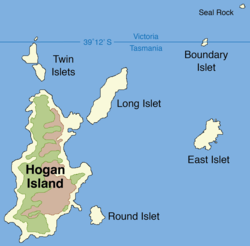 Map of Hogan Group showing Boundary Islet | |
 Boundary Islet Location of the Boundary Islet in Bass Strait | |
| Geography | |
|---|---|
| Location | Bass Strait |
| Coordinates | 39°11′54″S 147°01′18″E |
| Archipelago | Hogan Group |
| Area | 2 ha (4.9 acres) |
| Length | 141 m (463 ft) |
| Administration | |
Australia | |
| States |
|
Tasmania–Victoria land border
Boundary Islet is divided in the east–west direction at the latitude 39°12′ S, with the northern portion belonging to Victoria and the southern portion belonging to Tasmania. This is Tasmania's only land border, and at 85 metres (279 ft) long, it is the shortest land border between any two Australian states or territories.[2]
This situation is accidental, and arose as a result of an error made by Captain John Black, who surveyed the position of the islet in 1801 and determined its latitude to be slightly further north than it truly is. The boundary between Victoria and Tasmania was later set along the latitude of 39°12′ S, which was then thought to be completely south of Boundary Islet and not to traverse any land in Bass Strait.[3][4] This would have made the islet completely within the jurisdiction of Victoria. However, when Boundary Islet's correct latitude was later determined it was found to straddle the border. It is for this reason that what was once known as North East Islet (being situated in the north-east of the Hogan Group) came to be known as Boundary Islet.
See also
References
- "State and Territory Borders: Shortest Border". Geoscience Australia. Commonwealth of Australia. 11 September 2007. Archived from the original on 22 August 2008. Retrieved 18 September 2022.
A little known fact is that there is a land border between Tasmania and Victoria. Straddling the declared parallel line of latitude of 39° 12' S separating the two states is Boundary Islet.
- Jacobs, Frank (24 April 2012). "One Island, Two Countries". The New York Times. Retrieved 18 September 2022.
- Moore, Garry (April 2014). "The boundary between Tasmania and Victoria: Uncertainties and their possible resolution" (PDF). Traverse. The Institute of Surveyors Victoria (294): 5–7. Archived from the original (PDF) on 16 August 2016. Retrieved 10 April 2015.
- Taylor, Greg; Economou, Nicholas (2006). The Constitution of Victoria. Federation Press. pp. 17–. ISBN 978-1-86287-612-5.
Islands and islets of Victoria, Australia | |
|---|---|
| Near East Gippsland | |
| Near Corner Inlet | |
| Near Wilsons Promontory | |
| In Western Port | |
| In Port Phillip | |
| Near Portland Bay | |
| In rivers | |
| |
На других языках
- [en] Boundary Islet
[fr] Îlot Frontière
L'Îlot Frontière (Boundary Island ou Boundary Islet) est une petite île australienne située dans le détroit de Bass.[it] Boundary Islet
Boundary Islet è un piccolo isolotto dello stretto di Bass in Australia diviso tra gli stati di Victoria e Tasmania di cui costituisce anche l'unico confine terrestre (circa 90 metri di confine in comune sull'isolotto). L'isolotto fa parte dell'Hogan Group. Conosciuta in passato come North East Islet, la posizione dell'isola fu esaminata nel 1801 dal capitano britannico John Black, che commise un errore nel collocare l'isoletta più a nord di quello che è. In seguito si scoprì che il confine tra i due stati era a 39 ° 12 'S e passava attraverso l'isolotto[1][2].[ru] Баундари-Айлет
Ба́ундари-А́йлет (англ. Boundary Islet; с англ. — «Пограничный островок»), ранее известный как Норт-Ист-Айлет (англ. North East Islet; с англ. — «Северо-Восточный островок») — необитаемый островок в составе архипелага Хоган-Груп[en]. Через него проходит граница австралийских штатов Тасмания и Виктория[1][2][3].Другой контент может иметь иную лицензию. Перед использованием материалов сайта WikiSort.org внимательно изучите правила лицензирования конкретных элементов наполнения сайта.
WikiSort.org - проект по пересортировке и дополнению контента Википедии