geo.wikisort.org - Island
De Witt Island, also known as Big Witch, is an island located close to the south-western coast of Tasmania, Australia. The 516-hectare (1.99 sq mi) island is the largest of the Maatsuyker Islands Group, and comprises part of the Southwest National Park and the Tasmanian Wilderness World Heritage Site. The island is listed on the Australian Register of the National Estate.[2]
Nickname: Big Witch | |
|---|---|
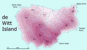 Detailed map of De Witt Island | |
 De Witt Island Location off the southern coast of Tasmania | |
| Etymology | Cornelis Jan Witsen, a Commissioner of the Dutch East India Company[1] |
| Geography | |
| Location | South West Tasmania |
| Coordinates | 43°35′24″S 146°21′00″E |
| Archipelago | Maatsuyker Islands Group |
| Adjacent bodies of water | Southern Ocean |
| Area | 516 ha (1,280 acres)[2]: 18 |
| Width | 3 km (1.9 mi)[3] |
| Highest elevation | 340 m (1120 ft)[3] |
| Administration | |
Australia | |
| State | Tasmania |
| Region | South West |
| Demographics | |
| Population | Unpopulated |
| Additional information | |
| Register of the National Estate | |
Location and features
De Witt Island lies some 6 kilometres (3.7 mi) south of Louisa Bay, on Tasmania's south coast. Abel Tasman discovered it in 1642 and named it Witsen or Wits Eijlanden.[1] The island is broadly triangular in shape, some 3 kilometres (1.9 mi) across, with cliffs ranging from 250 to 300 metres (820 to 980 ft) high to the south on all sides except a part of the central north coast. The highest parts of the island are located very close to the south coast, and enclose a north-facing basin. The island's 340-metre (1,120 ft) summit is located very close to its southernmost point.[3] Although currently uninhabited, it has a long history of human usage, including logging and occasional habitation.[2][4] The island is part of the Maatsuyker Island Group Important Bird Area, identified as such by BirdLife International because of its importance as a breeding site for seabirds.[5]
The island is extensively forested with the principal species being Eucalyptus nitida, swamp gum and messmate. Sheltered areas also have leatherwood and myrtle beech.[2]
Recorded breeding seabird and wader species are the little penguin (500 pairs), short-tailed shearwater (11,000 pairs), fairy prion (50 pairs), silver gull and sooty oystercatcher. Swift parrots have been recorded. Mammals present include the Tasmanian pademelon, long-nosed potoroo and swamp rat. Reptiles recorded are the metallic skink and Tasmanian tree skink.[2][4]
See also

- South East Cape
- South West Cape
- List of islands of Tasmania
References
- Heeres, J. E., ed. (2006). "Abel Janszoon Tasman's Journal of his Discovery of Van Diemen's Land and New Zealand in 1642 with Documents Relating to his Exploration of Australia in 1644...to which are added his Life and Labours, 1898". Project Gutenberg of Australia]. Retrieved 9 July 2006.
- "Small Southern Islands Conservation Management Statement 2002" (PDF). Tasmania Parks and Wildlife Service. 2002. Archived from the original (PDF) on 22 August 2006. Retrieved 20 July 2006.
- Dixon, G.; Houshold, I (1996). "Notes on the geology and geomorphology of De Witt Island, southwest Tasmania". Papers and Proceedings of the Royal Society of Tasmania. 130 (1): 67–74. doi:10.26749/rstpp.130.1.67. ISSN 0080-4703.
- Brothers, Nigel; Pemberton, David; Pryor, Helen; & Halley, Vanessa. (2001). Tasmania’s Offshore Islands: seabirds and other natural features. Tasmanian Museum and Art Gallery: Hobart. ISBN 0-7246-4816-X
- BirdLife International. (2011). Important Bird Areas factsheet: Maatsuyker Island Group. Downloaded from "BirdLife | Partnership for nature and people". Archived from the original on 10 July 2007. Retrieved 2012-12-14. on 09/08/2011.
| Authority control |
|
|---|
This Tasmania geography article is a stub. You can help Wikipedia by expanding it. |
На других языках
[de] De Witt Island
De Witt Island ist die größte Insel der Maatsuyker-Inseln und hat eine Fläche von 517 Hektar. Nahe der Südküste Tasmaniens gelegen gehört sie auch zum Southwest-Nationalpark. Obwohl sie derzeit unbewohnt ist, wurde sie doch lange Zeit genutzt, vor allem zur Holzgewinnung, aber auch als gelegentliche Wohnstätte.- [en] De Witt Island
[it] De Witt Island
De Witt Island fa parte del gruppo delle Maatsuyker Islands, isole site a sud dell'isola di Tasmania (Australia) nell'oceano antartico e appartenenti alla municipalità di Huon Valley, una delle Local government area della Tasmania. Tutto il gruppo di isole appartiene al Southwest National Park[3] che a sua volta fa parte della Tasmanian Wilderness World Heritage Area[4].[ru] Де-Уитт (остров)
Де-Уитт (англ. De Witt Island) — остров у южного побережья острова Тасмания (Австралия), входит в состав штата Тасмания. Площадь острова — 5,16 км²[1]. Иногда употребляется другое название этого острова — Биг-Уитч (англ. Big Witch). Территория острова является частью национального парка Саут-Уэст[1].Другой контент может иметь иную лицензию. Перед использованием материалов сайта WikiSort.org внимательно изучите правила лицензирования конкретных элементов наполнения сайта.
WikiSort.org - проект по пересортировке и дополнению контента Википедии