geo.wikisort.org - Island
The South West Isle, part of the Kent Group, is an unpopulated 19.09-hectare (47.2-acre) granite island, located in the Bass Strait, lying off the north-east coast of Tasmania, between the Furneaux Group and Wilsons Promontory in Victoria, Australia.[1]
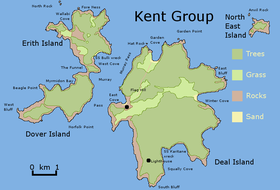
 The South West Isle, as located within the Kent Group. | |
 South West Isle Location of the South West Isle in Bass Strait | |
| Geography | |
|---|---|
| Location | Bass Strait |
| Coordinates | 39°31′12″S 147°07′12″E |
| Archipelago | Kent Group |
| Area | 19.1 ha (47 acres) |
| Highest elevation | 120 m (390 ft) |
| Administration | |
Australia | |
| State | Tasmania |
| Demographics | |
| Population | unpopulated |
The island has a peak elevation of 120 metres (390 ft) and is contained within the Kent Group National Park, Tasmania's northernmost national park, which was gazetted in 2002.
Fauna
Recorded breeding seabird, wader and waterbird species include little penguin, short-tailed shearwater, fairy prion, common diving-petrel, Pacific gull, silver gull, sooty oystercatcher and Cape Barren goose. Reptiles present are the metallic skink, Bougainville's skink and White's skink.[2]
See also
- List of islands of Tasmania
- Protected areas of Tasmania
References
- "South West Isle (TAS)". Gazetteer of Australia online. Geoscience Australia, Australian Government.
- Brothers, Nigel; Pemberton, David; Pryor, Helen; & Halley, Vanessa. (2001). Tasmania’s Offshore Islands: seabirds and other natural features. Tasmanian Museum and Art Gallery: Hobart. ISBN 0-7246-4816-X
External links
- Parks and Wildlife Service (2005). Kent Group National Park (Terrestrial Portion) Management Plan 2005. Department of Tourism, Parks, Heritage and the Arts. Hobart: Tasmanian Government. ISBN 0-9751743-4-7.
Текст в блоке "Читать" взят с сайта "Википедия" и доступен по лицензии Creative Commons Attribution-ShareAlike; в отдельных случаях могут действовать дополнительные условия.
Другой контент может иметь иную лицензию. Перед использованием материалов сайта WikiSort.org внимательно изучите правила лицензирования конкретных элементов наполнения сайта.
Другой контент может иметь иную лицензию. Перед использованием материалов сайта WikiSort.org внимательно изучите правила лицензирования конкретных элементов наполнения сайта.
2019-2025
WikiSort.org - проект по пересортировке и дополнению контента Википедии
WikiSort.org - проект по пересортировке и дополнению контента Википедии