geo.wikisort.org - Island
Flat Top Island is an island located close to the south-western coast of Tasmania, Australia. The 1.58-hectare (0.0061 sq mi) island is part of the Maatsuyker Islands Group, and comprises part of the Southwest National Park and the Tasmanian Wilderness World Heritage Site.[1][2]
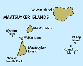 Detailed map of the Maatsuyker Islands Group, showing Flat Top Island on the right | |
| Geography | |
|---|---|
| Location | South West Tasmania |
| Coordinates | 43°37′48″S 146°22′48″E |
| Archipelago | Maatsuyker Islands Group |
| Adjacent bodies of water | Southern Ocean |
| Area | 1.58 ha (3.9 acres)[1]: 21 |
| Administration | |
Australia | |
| State | Tasmania |
| Region | South West |
| Demographics | |
| Population | Unpopulated |

Fauna
The island is part of the Maatsuyker Island Group Important Bird Area, identified as such by BirdLife International because of its importance as a breeding site for seabirds.[3] Recorded breeding seabird species are the short-tailed shearwater (400 pairs), fairy prion (5000 pairs), common diving-petrel (1000 pairs) and Pacific gull. The island is a haul-out site for the Australian fur seal. The Tasmanian tree skink is present.[1][2]
See also
- South East Cape
- South West Cape
- List of islands of Tasmania
References
- "Small Southern Islands Conservation Management Statement 2002" (PDF). Tasmania Parks and Wildlife Service. 2002. Archived from the original (PDF) on 22 August 2006. Retrieved 20 July 2006.
- Brothers, Nigel; Pemberton, David; Pryor, Helen; & Halley, Vanessa. (2001). Tasmania’s Offshore Islands: seabirds and other natural features. Tasmanian Museum and Art Gallery: Hobart. ISBN 0-7246-4816-X
- BirdLife International. (2011). Important Bird Areas factsheet: Maatsuyker Island Group. Downloaded from "BirdLife International - conserving the world's birds". Archived from the original on 10 July 2007. Retrieved 13 April 2013. on 09/08/2011.
This Tasmania geography article is a stub. You can help Wikipedia by expanding it. |
Другой контент может иметь иную лицензию. Перед использованием материалов сайта WikiSort.org внимательно изучите правила лицензирования конкретных элементов наполнения сайта.
WikiSort.org - проект по пересортировке и дополнению контента Википедии