geo.wikisort.org - Island
Matty Island is one of the Canadian arctic islands in the Kitikmeot Region, Nunavut. It is located in Rae Strait, between King William Island and the Boothia Peninsula. Located at 69°29'N 95°40'W it has an area of 477 km2 (184 sq mi).[1]
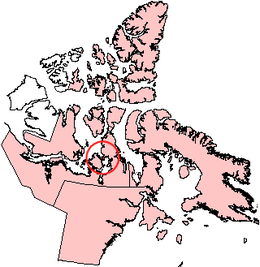 Matty Island, Nunavut. | |
 Matty Island  Matty Island | |
| Geography | |
|---|---|
| Location | Rae Strait |
| Coordinates | 69°29′N 95°40′W |
| Archipelago | Arctic Archipelago |
| Area | 477 km2 (184 sq mi) |
| Administration | |
Canada | |
| Territory | Nunavut |
| Region | Kitikmeot |
| Demographics | |
| Population | Uninhabited |
Other islands in the area include Beverly Islands to the south, and Tennent Islands to the west.
References
- "The Atlas of Canada - Sea Islands". Natural Resources Canada. Archived from the original on 2010-07-02. Retrieved 2011-05-05.
This Kitikmeot Region, Nunavut location article is a stub. You can help Wikipedia by expanding it. |
На других языках
- [en] Matty Island
[fr] Île Matty
L’île Matty (anglais : Matty Island) est une île de l'archipel arctique canadien, plus précisément entre la péninsule Boothia et l'île du Roi-Guillaume dans le territoire canadien du Nunavut. Elle a une superficie de 477 km2.[it] Isola Matty
Matty è un'isola disabitata del Canada situata nell'Arcipelago artico canadese nel territorio del Nunavut. È situata tra l'Isola di Re Guglielmo e la Boothia e possiede una superficie di 477 km². A ovest, lo stretto di Wellington la separa dalle isole Tennent.[ru] Матти (остров)
Матти (англ. Matty Island ) — остров Канадского Арктического архипелага. В настоящее время остров необитаем (2012).Текст в блоке "Читать" взят с сайта "Википедия" и доступен по лицензии Creative Commons Attribution-ShareAlike; в отдельных случаях могут действовать дополнительные условия.
Другой контент может иметь иную лицензию. Перед использованием материалов сайта WikiSort.org внимательно изучите правила лицензирования конкретных элементов наполнения сайта.
Другой контент может иметь иную лицензию. Перед использованием материалов сайта WikiSort.org внимательно изучите правила лицензирования конкретных элементов наполнения сайта.
2019-2026
WikiSort.org - проект по пересортировке и дополнению контента Википедии
WikiSort.org - проект по пересортировке и дополнению контента Википедии