geo.wikisort.org - Mountains
Mount Kujū (九重山, Kujū-san) is the highest mountain in Kyushu Island, Japan. It is one of the 100 Famous Japanese Mountains. The 1,791-metre-high (5,876 ft) mountain lies on the border of Kokonoe and Taketa in Ōita Prefecture on the island of Kyushu. They are part of Aso-Kujū National Park.
This article may be expanded with text translated from the corresponding article in Japanese. (July 2012) Click [show] for important translation instructions.
|
| Mount Kujū | |
|---|---|
| 九重山 | |
 Kujū Mountains | |
| Highest point | |
| Elevation | 1,791 m (5,876 ft)[1] |
| Prominence | 1,791 m (5,876 ft)[1] |
| Listing | Ultra 100 Famous Japanese Mountains |
| Coordinates | 33°04′54″N 131°14′24″E[1] |
| Naming | |
| Language of name | Japanese |
| Geography | |
 Mount Kujū Japan | |
| Location | On the border of Kokonoe and Taketa, Ōita, Japan |
| Parent range | Kujū Mountains |
| Geology | |
| Mountain type | Stratovolcano |
| Last eruption | 1995 to 1996 |

Summary
The Kujū range consists of a dozen or so volcanic bodies gathered in a region of 13km east-west and 10km north-south. The mountains in the range include:
- Kujū Mountains
- Mount Kujū (1,787 m)- The main peak (久住山)
- Mount Nakadake (1,791 m)- The highest peak in Kyushu
- Mount Inahoshi (1,774 m)
- Mount Hōsshō (1,762 m)
- Mount Mimata (1,745 m)
- Taisen Mountains
- Mount Taisen (1,786 m)
- Mount North (Kita) Taisen (1,706 m)
- Mount Heiji (1,642 m)
The Kujū volcanic group is mainly composed of andesite and dacite, which is defined as the volcanic activity above the Miyagi pyroclastic flow deposit which formed about 200,000 years ago. The north and south areas of Mt. Kujū are plateau grasslands whose main industry is dairy farming.
Gallery
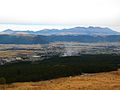 Mount Kujū from Mount Aso
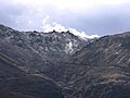 Mount Iō from Chōjabaru
 Mount Hōsshō and Mount Iō from Chōjabaru
 Mount Kujū from Narukogawa Gorge
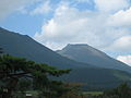 Mount Taisen
 Kujū Flower Gardens and Kujū Mountains
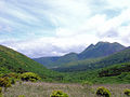 Mount Kujū from Makinoto Pass with Mount Mimata on the right


See also
References
- "Japan Ultra-Prominences". Peaklist.org. Retrieved 2015-01-01.
External links
- Kujusan - Japan Meteorological Agency (in Japanese)
- "Kujusan: National catalogue of the active volcanoes in Japan" (PDF). - Japan Meteorological Agency
- Kuju - Geological Survey of Japan
- "Kujusan". Global Volcanism Program. Smithsonian Institution. Retrieved 2021-06-25.
| Hokkaidō | |||||||||
|---|---|---|---|---|---|---|---|---|---|
| Tōhoku region Jōshinetsu region |
| ||||||||
| Kantō region | |||||||||
| Chūbu region |
| ||||||||
| Western Japan | |||||||||
| |||||||||
Authority control | |
|---|---|
| General |
|
| National libraries | |
This Ōita Prefecture location article is a stub. You can help Wikipedia by expanding it. |
На других языках
- [en] Mount Kujū
[fr] Monts Kujū
Les monts Kujū (九重山, Kujū-san?) sont une des 100 montagnes célèbres du Japon. D'une altitude moyenne de 1 700 m, le massif se situe à la limite de Kokonoe et Taketa dans la préfecture d'Ōita. Ils se trouvent dans le parc national d'Aso-Kujū.Другой контент может иметь иную лицензию. Перед использованием материалов сайта WikiSort.org внимательно изучите правила лицензирования конкретных элементов наполнения сайта.
WikiSort.org - проект по пересортировке и дополнению контента Википедии